Showing 2722 items
matching south side
-
 Kew Historical Society Inc
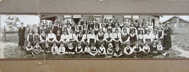
Photograph - Woodbury Ladies’ College, 1919
... .1903. The first school was in a rented building on the south.... The first school was in a rented building on the south side ...Woodbury College is an indirect predecessor of Preshil School in Kew. Woodbury College was founded in Glenferrie Road by a Miss Harcourt, former principal of Sydenham College, Moonee Ponds. Miss Harcourt maintained the school until the goodwill was purchased in 1908 by Miss LJ Macey, who had previously operated Lillsden Ladies' College in Edgevale Road, between c.1891 and c.1903. The first school was in a rented building on the south side of Cotham Road between Atkins and Davis Streets. In 1910, a new school building was built on the corner of Uvadale Grove and Cotham Road [the building is still extant as of 2020]. Woodbury College was operated by Miss LJ and Miss HJ Macey until 1920. In 1921, the school amalgamated with the newly formed St Andrew's College, Mont Victor Road, Kew (Vic) under the leadership of Rev JT Lawton [who had previously been principal of St Andrew's School of the 'Pathfinder' in South Yarra]. Miss Macey was for a period the Headmistress of the amalgamated school. Another teacher at the school was Miss Margaret JR Lyttle, who in 1931, left St Andrew's to form the Preshil School.A rare panoramic photograph of Woodbury College in Kew, Victoria. The photograph is part of a large collection of original manuscripts and ephemera relating to the school.Panoramic photograph of the students and teachers of Woodbury College, Cotham Road (Kew). Students identified in the photograph include: Back Row, 5th from left Betty Paton; 4th from right - Jean Strickey (sic).Annotation to reverse: "Woodbury College (Miss L.J. Massey) established Cotham Rd Kew. Est. at this venue 1908. Later joined by Rev. J.T. Lawton & formed a school in Mount Victor Rd Kew St Andrew’s College in 1921.’ woodbury college, cotham road (kew), education, schools, kew, l.j. massey, j.t. lawton, st andrew's college -
 Melbourne Tram Museum
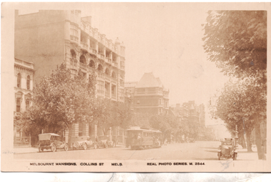
Postcard, Valentine's, "Melbourne Mansions Collins St Melb", 1919c
... . There are several parked cars and horse drawn wagons on the south side.... There are several parked cars and horse drawn wagons on the south side ...Postcard Real photo number M2844, titled "Melbourne Mansions Collins St Melb", by Valentine Sons. Featuring a west bound cable tram set in Collins Street between Exhibition and Russell Streets bound for Spencer Street, The trailer car appears to be No 52 and also has a non-standard destination box fitted on the side. The Melbourne Mansions Building. 91 - 101 Collins Street, was funded by David Syme proprietor of The Age newspaper and built in 1906. It is thought to be the first block of residential flats within the city limits. The building was demolished in 1958 to make way for Consolidated Zinc Building (CRA) completed in 1962. but since demolished. The large building further along Collins Street is the Austral Building completed in 1891. There are several parked cars and horse drawn wagons on the south side of Collins Street and an early Morris Oxford (Bullnose) on the northside. Behind that is one of the early ornate electric street lighting poles of the era. The photo has been taken around 1919 as the fourth floor addition to The Alexandra Club is visible in the photo. Unfortunately this particular copy of the photo has faded over time.Demonstrates a Valentine and Sons Real photograph postcard.Postcard - Real photograph - divided back unused.cable trams, collins st, tramways, tram 52 -
 Bendigo Historical Society Inc.
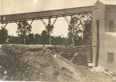
Photograph - MINE SHED WITH TRESTLEWAY IN BACKGROUND
... , shed attached on side. Possibly South New Moon Mine site... MINES Mining equipment South New Moon Mine site Corrugated iron ...Corrugated iron shed, large rectangular opening in front, shed attached on side. Possibly South New Moon Mine site, Eaglehawk, 1940's.gold mines, mining equipment, south new moon mine site -
 Sunshine and District Historical Society Incorporated
Photograph - Three Old Sunshine Factories, Pratt, Charles Daniel, (1892 - 1968), Photographed circa late 1920's to early 1930's
... is still an undivided road and on the south side is a plantation... is still an undivided road and on the south side is a plantation ...These three factories clustered together and close to Albion Station provided manufacturing type of employment for several decades. All the factories have now disappeared and have been replaced by retail or service businesses. Spalding has been replaced by a Bunnings Hardware store, while the main retail outlet on the Nettlefolds site is Harvey Norman. Ironically part of the Phoenix Fireworks site is now occupied by the Metropolitan Fire Brigade, as well as other small businesses including a smash repair business, and a tyre retailer.The photograph provides a historical record of some of the types of manufacturing industries that existed in Sunshine, before retail or service industries began to replace them. Many of the younger generation do not know that fireworks, screws, or some sports items were manufactured in Sunshine not so long ago, and where the factories existed.The image depicted in this photographic copy is believed to be from circa late 1920's to early 1930's, and shows the NETTLEFOLDS, SPALDING, and the PHOENIX FIREWORKS factories. These factories were located in North Sunshine on the north side of Ballarat Road near Albion Station. Nettlefolds and Spalding are on the corner of Ballarat Road and McIntyre Road, with Nettlefolds being on the west side of McIntyre Road and Spalding on the east. Phoenix Fireworks factory is composed of small huts, and is situated on the north side of Phoenix Street at the rear of the Spalding factory. The photograph also shows a row of residential houses on Garnet Street which is on the east side of the Phoenix factory. Ballarat Road is still an undivided road and on the south side is a plantation of trees that once stretched from near Albion Station to Anderson Road. Other roads visible are Suffolk Road and Westmoreland Road.Nettlefolds Screw Worksnettlefolds, spalding, phoenix fireworks, screw works, ballarat road, mcintyre road, phoenix street, garnet street, westmoreland road, suffolk road. -
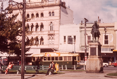
 Ballarat Tramway Museum
Photograph - Digital image Set of 3, Chris Phillips, 30/05/1971 12:00:00 AM
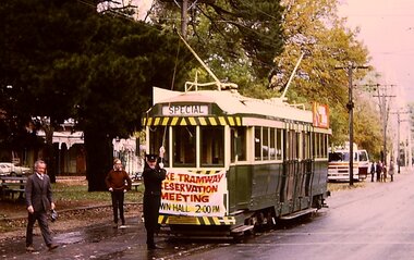
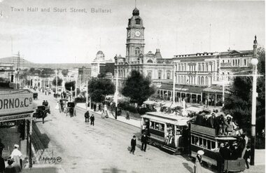
... buildings in the background. .3 - tram at the City stop, south... at the City stop, south side of Sturt St with the Town Hall and Myers ...Yields information about the special tram and the people involved at the time of the formation of the BTPS prior to closure of the SEC operated system.Set of three digital images of tram 36 advertising the Lake Tramway Preservation Meeting at the Town Hall 31/5/1971 by Chris Phillips. .1 - tram at Gardens loop with the motorman L Bird pulling the pole down - similar photo to that of The Age Newspaper, see Reg Item 2487. .2 - tram turning from Sturt St into Lydiard St North with the Post Office and the Mining Exchange buildings in the background. .3 - tram at the City stop, south side of Sturt St with the Town Hall and Myers in the background. Also has the tram stop signs in the photograph. See also Reg Item 1064 for the newspaper clipping, 2487 for a print of The Age photograph. See 7033i4 for notes on the tram and who made the banner - thought to be Tom Clark. Imagebtm7033i2bw - black and white version of the slide use in the Long Gallery imagebtm7033i2co - colour hi res scan.trams, tramways, lake wendouree, charters, museum establishment, btps, sturt st, gardens, lydiard st north -
 Ballarat Tramway Museum
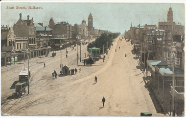
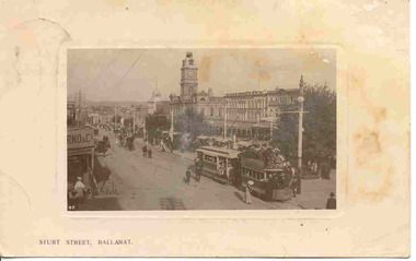
Postcard, WTP, electric tram leaving the Grenville St. terminus
... to the south side of Sturt St. Has buildings on both sides of Sturt... to the south side of Sturt St. Has buildings on both sides of Sturt St ...Yields information about Ballarat and Sturt St c1907 following the information of trams.Printed colour postcard of Ballarat electric tram leaving the Grenville St. terminus, at the bottom end of Sturt St terminus with an early motor bus or taxi in front of the tram crossing to the south side of Sturt St. Has buildings on both sides of Sturt St. in photograph, with some other horse drawn vehicles and many pedestrians. Note, none of the buildings have names shown on them - have been printed out. Photo taken soon after opening, no roof mounted destination boxes. On rear are places for correspondences stamp, address and manufacturers' name in a fancy motif "WTP". Titled "Sturt Street, Ballarat" in the top left-hand corner". 2924.1 - Same postcard from the Wal Jack Album, see images i3 and i4 for front and rear. The rear of the postcard has a message written on it. 2924.2 - colour illustration from a publication.On rear in ink - addressed to Mrs Wolfenden of Prahran Melbourne, with a message from her daughter, dated 8-1-1907, has had stamp removed.trams, tramways, sturt st, postcards, esco, buses, grenville st -
 Ballarat Tramway Museum
Photograph - Black & White Photograph/s, c1906
... buildings along the south side of Sturt St. and part of the verandah... in the photograph. Shows buildings along the south side of Sturt St ...Demonstrates the use of horse trams as trailers after the start of the electric trams in Ballarat and the street scape and tramway loading at the same time.B&W print of an ESCo tram just past the intersection of Doveton St. and Sturt St. travelling east along the north side of Sturt. Steet towing a heavily laden horse tram as a trailer. Photo appears to be taken soon after opening of the electric trams, as the tram does not have any destination box above the driver. Possibly summer 1905/1906. Numerous people in the street, some horse drawn vehicles in the photograph. Shows buildings along the south side of Sturt St. and part of the verandah of the building at the NE corner of Doveton St. On textured photographic paper. For a list and description of the same base image see Archives file - "Notes on ESCo Tram towing a heavily loaded trailer" 2nd copy added 6-8-2016 from a donation of Mike Ryan via Hawthorn Tram Depot.On reverse side - black ink stamp "E.G.Butland" Copy 2 has "TMSV 332 Flinders St, Melbourne 3000" stamped on the rear.tramways, trams, sturt st, trailers, horse tram, town hall, esco -
 Ballarat Tramway Museum
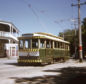
Slide - 27 mm sq slide/s - set of 5, Andrew Howlett, Tram 26 on private tour - View Point line, Mar. 1969
... then reversed a bit before going back into Sturt St onto the South side... before going back into Sturt St onto the South side. One ...Yields information about a special tram service during March 1969 and some unusual moves.Set of four Colour slides, Kodak white cardboard mount, developed March 1969 of a special tram that apparently ran from the depot via View Point, shunted at Ripon St and again at Hospital corner. ..1 - No. 26 running a special in Wendouree Parade, View Point, with the Lake View Hotel. .2 - ditto - and a catering company in the view, as well as a Telephone box. .3 - running from Ripon St into Sturt St. .4 - shunting at Hospital corner - then possibly crossed 34 at Parker St Loop - see 7668. .5 - ditto, but before .4, with the tram rounding the corner from the North side of Sturt St into Drummond St. It would then appear that the tram then reversed a bit before going back into Sturt St onto the South side. One of a series of tour photos - see Reg item 7667, 7668, 7683 and 7701.ballarat, tramways, trams, view point, wendouree parade, ripon st, hospital corner, sturt st, tours, tram 26 -
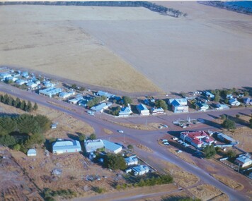
 Bendigo Historical Society Inc.
Photograph - Aerial shots of parts of Bendigo 1934, 1934
... on the south side of the city; the extent of which covers approximately... of the goldfields on the south side of the city; the extent of which covers ...AERIAL SHOTS OF PARTS OF BENDIGO 1934 Catalogue No.10584 This document contains scans of a unique set of aerial photographs that were taken over the City of Bendigo on Friday 12th January 1934, at about midday. The photographs were commissioned by Bendigo Mines Limited during their exploration and mining program designed to revitalize the Bendigo Goldfield. The photographs were given to the Victorian Mines Department sometime in the 1950s. The photographs were taken at a relatively low level of about 4000 feet. This gives a very detailed picture of Bendigo as it was in the 1930s. The photos cover the City Centre and are mainly of the goldfields on the south side of the city; the extent of which covers approximately the four corners of Myers Flat, Maiden Gully, Mandurang and One Tree Hill. Streets, roads and places of interest have been identified as best as possible in December 2023. There are 44 maps, and each references the adjoining maps.Typed Notes with CD The CD is one of two and contains a set of 46 images: The folder named "High_Resolution_800dpi" contains the original digital files that were produced by scanning the photographic prints (About A3 size) at 800 dpi using a high quality, large pformat, roll scanner. These files may be too large for some computers. A second CD contains a direstory called "Low_Resolution_300dep" The images in the folder names "Low_Reolution_300dpr" have a lower resolution (300 dpi) and have been rotated 90 degrees clockwise so that the Northern margin of each image is a the top of the screen. Clive Willman Senior Geologist Geological Survey of Victoriahistory, bendigo, bendigo mines, bendigo maps, bendigo aerial photos -
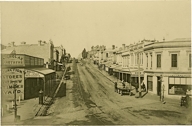 Kew Historical Society Inc
Photograph, J F C Farquhar, High Street, Kew, 1891
... the original alignment of buildings on the south side. These included... includes the original alignment of buildings on the south side ...At the beginning of the 1890s, the Kew businessman and Town Councillor, Henry Kellett, commissioned J.F.C. Farquhar to photograph scenes of Kew. These scenes included panoramas as well as pastoral scenes. The resulting set of twelve photographs was assembled in an album, Kew Where We Live, from which customers could select images for purchase.The preamble to the album describes that the photographs used the ‘argentic bromide’ process, now more commonly known as the gelatine silver process. This form of dry plate photography allowed for the negatives to be kept for weeks before processing, hence its value in landscape photography. The resulting images were considered to be finely grained and everlasting. Evidence of the success of Henry Kellett’s venture can be seen today, in that some of the photographs are held in national collections.It is believed that the Kew Historical Society’s copy of the Kellett album is unique and that the photographs in the book were the first copies taken from the original plates. It is the first and most important series of images produced about Kew. The individual images have proved essential in identifying buildings and places of heritage value in the district.In 1891, High Street was the centre of commercial activity in the Borough of Kew. It was unpaved and edged with deep bluestone gutters, which were designed to channel the significant flow of storm water down the hill to and beyond the Junction. On either side of the entrance to the shopping strip are two cast iron gas lamps that provided the only public street lighting before the Post Office was reached. Most shops, including the Nicholas Brothers’ Junction Store featured cast iron verandas. Further up the hill, Dougherty’s Greyhound Hotel was by this stage a local institution. Apart from the horse-drawn tram, the main form of personal and commercial transport in this period remained the horse, horse and cart, or buggy.The panoramic view predates the widening of High Street in the 20th century, and thus includes the original alignment of buildings on the south side. These included Henry Kellett’s shop.High Street, Kewkew illustrated, kew where we live, photographic books, henry kellett, high street - kew (vic) -
 Kew Historical Society Inc
Photograph, J F C Farquhar, Studley Park Road, 1891
... pickets to surround the newly planted avenue of elms on the south... pickets to surround the newly planted avenue of elms on the south ...At the beginning of the 1890s, the Kew businessman and Town Councillor, Henry Kellett, commissioned J.F.C. Farquhar to photograph scenes of Kew. These scenes included panoramas as well as pastoral scenes. The resulting set of twelve photographs was assembled in an album, Kew Where We Live, from which customers could select images for purchase.The preamble to the album describes that the photographs used the ‘argentic bromide’ process, now more commonly known as the gelatine silver process. This form of dry plate photography allowed for the negatives to be kept for weeks before processing, hence its value in landscape photography. The resulting images were considered to be finely grained and everlasting. Evidence of the success of Henry Kellett’s venture can be seen today, in that some of the photographs are held in national collections.It is believed that the Kew Historical Society’s copy of the Kellett album is unique and that the photographs in the book were the first copies taken from the original plates. It is the first and most important series of images produced about Kew. The individual images have proved essential in identifying buildings and places of heritage value in the district.In this view of Studley Park Road, looking northeast to the Junction, the photographer invites the viewer to participate in a point-of-view that emphasises the elevated, tranquil vantage point of the hill in contrast to the bustling commercial area in the distance. The view emphasises the exclusiveness of Studley Park, with its high fences behind which a number of significant Kew mansions were concealed. Contemporary advertisements for the sale of mansions in Studley Park Road often included fulsome descriptions of their elaborate formal gardens, as well as paddocks for grazing, stabling and dairies. None can be seen here. The use of high, protective wooden pickets to surround the newly planted avenue of elms on the south side of the road appears to be typical of the period. Similar examples can be seen in early photographs of Wellington and Princess Streets.The horse and carriage, selected as a central focus of the view, reinforces the residential, exclusive nature of this part of Kew in the early 1890s. Studley Park Roadkew illustrated, kew where we live, photographic books, henry kellett -
 Kew Historical Society Inc
Plan - Subdivision Plan, J R Mathers & McMillan, Glenarbor Estate, 1934
... with the decision to widen High Street on the South side between Cotham Road... on the South side between Cotham Road and the Junction. Glenarbor ...Pru Sanderson, in her groundbreaking ‘City of Kew Urban Conservation Study : Volume 2 - Development History’ (1988), summarised the periods of urban development and subdivisions of land in Kew. The periods that she identified included 1845-1880, 1880-1893, 1893-1921, 1921-1933, 1933-1943, and Post-War Development. These periods were selected as they represented periods of rapid growth or decline in urban development. An obvious starting point for Sanderson’s groupings involved population growth and the associated economic cycles. These cycles also highlighted urban expansion onto land that was predominantly rural, although in other cases it represented the decline and breakup of large estates. A number of the plans in the Kew Historical Society’s collection can also be found in other collections, such as those of the State Library of Victoria and the Boroondara Library Service. A number are however unique to the collection.The Kew Historical Society collection includes almost 100 subdivision plans pertaining to suburbs of the City of Melbourne. Most of these are of Kew, Kew East or Studley Park, although a smaller number are plans of Camberwell, Deepdene, Balwyn and Hawthorn. It is believed that the majority of the plans were gifted to the Society by persons connected with the real estate firm - J. R. Mathers and McMillan, 136 Cotham Road, Kew. The Plans in the collection are rarely in pristine form, being working plans on which the agent would write notes and record lots sold and the prices of these. The subdivision plans are historically significant examples of the growth of urban Melbourne from the beginning of the 20th Century up until the 1980s. A number of the plans are double-sided and often include a photograph on the reverse. A number of the latter are by noted photographers such as J.E. Barnes.The little-known Glenarbor Estate comprised 23 allotments bordering Wellington and Denmark Streets and Fenton Avenue. The auction of the allotments in the Estate was held in the Kew Recreation Hall. The purported advantages to Kew are identified on the plan, such as the close proximity of the entrance to the Kew Railway Station and access to shops in Denmark Street. Due to its location, the subdivision was pitched at commercial as well as residential purchasers. The Estate was to cause a crisis in the Kew Council as a majority of councillors voted on 29 May to acquire the entire Estate as the location of a new Town Hall. The Estate was said to be valued at £50,000. A later meeting was to rescind the vote, instead opting for the compulsory acquisition of South Esk on the corner of Charles Street and Cotham Road. That acquisition was to be overturned by the State Government. The debate about the purchase of the Glenarbor Estate by Council coincided with the decision to widen High Street on the South side between Cotham Road and the Junction."D"subdivision plans - kew, glenarbor estate, wellington street, denmark street -
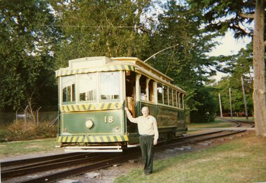 Ballarat Tramway Museum
Photograph - Colour Photograph/s - set of 12, Jenny Puls, 13/03/1996 12:00:00 AM
... the south side .4 - Close up photo showing marks on rail from... the south side .4 - Close up photo showing marks on rail from ...Set of twelve colour photographs of the derailment of Tram No. 18 on the depot fan (2 and 3 road points) on 13 March 1996. Included within the cataloguing sheet are a copy of the report to the traffic manager and the envelope from Frank Puls. Photographs by Jenny Puls, on Kodak paper. The report is a photocopy of the original held by the Traffic Manager. .1 - Frank standing by No. 18 .2 - No. 1 end showing derailed wheel .3 - From the south side .4 - Close up photo showing marks on rail from the wheel. .5 - From the north side .6 - Dave Macartney locating jacks .7 - Looking west towards the depot .8 - From the northside during rerailing .9 - Alan Snowball holding towbar with 661 in the background .10 - 18 and 661 .11 - Being coupled to No. 38 .12 - Being towed back on with Alan Snowball observing. On rear of each photo in stamped in black ink "13 March 1996"accidents, btm, derailments, depot fan, tram 18, tram 661, tram 38 -
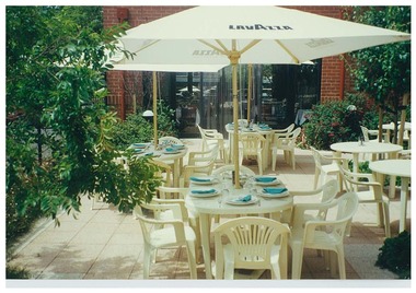 Queen Victoria Women's Centre
Photograph, c. 1998
... Colour photograph. Courtyard on ground floor eastern side.... Courtyard on ground floor eastern side facing south into the cafe ...Colour photograph. Courtyard on ground floor eastern side facing south into the cafe area and Lonsdale street. Outdoor seating area of the Cafe. Taken for the QMag Newsletterphotograph, outdoor furniture, cafe -
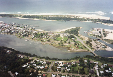 Lakes Entrance Historical Society
Photograph - Lakes Entrance, 1997c
... Colour print of aerial view looking south of western side... south of western side of township. Shows housing on Kalimna Hill ...Colour print of aerial view looking south of western side of township. Shows housing on Kalimna Hill, North Arm, part of Bullock Island, Cunninghame Arm, the outer barrier and east pier of man made entrance. Lakes Entrance Victoriawaterways, township -
 Ballarat Tramway Museum
Photograph - B&W print of donated negative - set of 5, Graham Parry, 1971
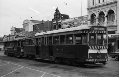
... buildings. .5 - as for .4, but from the south side footpath... the south side footpath with trams 43, 31, 26 and another ...Yields information about the City Loop and tram operations in Sturt St, 1971Set of five black and white prints and associated negatives of trams in Ballarat during 1971 prior to closure of the system by Graham Parry. All images from the scanned negative. .1 - No. 43 and possibly 31 in the City Loop. Has various buildings in the background. .2 - No. 34 at the Sturt and Lydiard Sts tram stop. Has the National Mutual Building in the background, which has a CML (Colonial Mutual Life) sign on it. .3 - No.35 at the north side tram stop. Has a Briquettes roof advert. Tram has the destination of Lydiard St North. .4 - View looking from the top of the hill at the City Loop with 43 and other cars in the loop. Has the Dickens Food Store and Patersons in the view along with other buildings. .5 - as for .4, but from the south side footpath with trams 43, 31, 26 and another in the loop. All have SEC roof adverts.tramways, trams, sturt st, city loop, lydiard st nth, tram 43, tram 31, tram 34, tram 35, tram 26 -
 Ballarat Tramway Museum
Postcard, John Phillips, Sturt St. Ballarat, - horse tram trailer
... in the photograph. Shows buildings along the south side of Sturt St... along the south side of Sturt St. and part of the verandah ...B&W print and scanned images of a coloured postcard lent to the BTM by Mr. Norm DePomeroy, Dec. 1997. Image is an ESCo tram just past the intersection of Doveton St. and Sturt St. travelling east along the north side of Sturt. Steet towing a heavily laden horse tram as a trailer. Photo appears to be taken soon after opening of the electric trams, as the tram does not have any destination box above the driver. Possibly summer 1905/1906. Numerous people in the street, some horse drawn vehicles in the photograph. Shows buildings along the south side of Sturt St. and part of the verandah of the building at the NE corner of Doveton St. 1 copy held at 8/98. For a list and description of the same base image see Archives file - "Notes on ESCo Tram towing a heavily loaded trailer" See Reg item 4275 for other black and white prints of this photograph and 162 for the coloured postcard. See 835i3. In top of image are the words "Town Hall and Sturt Street, Ballarat"trams, tramways, esco, horse trams, postcards, doveton st, sturt st -
 Ballarat Tramway Museum
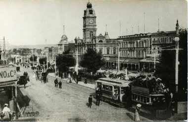
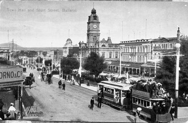
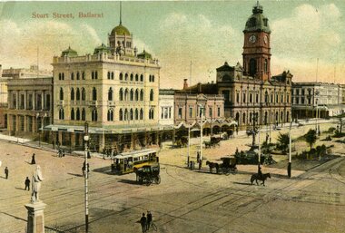
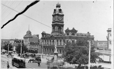
Postcard, JE, "Sturt St Ballarat", 1905
... on the south side of Sturt St., west of Lydiard St in the view. Has..., with buildings on the south side of Sturt St., west of Lydiard St ...Yields information about the appearance of SEC single truck trams during 1938. Has a strong association with Wal Jack.Printed colour postcard of an ESCo tram west bound at the intersection of Sturt and Lydiard St. Ballarat, c1905. Has a number of horse drawn vehicles and pedestrians in the picture. Taken from the Post Office tower looking south west, with buildings on the south side of Sturt St., west of Lydiard St in the view. Has the Robert Burns statue in the bottom left hand corner. Titled "Sturt Street, Ballarat" along the top edge. On rear of postcard are the words "Post Card", on either side of a symbol "JE" within a diamond, a 1d Victorian stamp. Divided back type. Address to Mrs, C. Harkneww 21 Alma St North Sydney NSW, from a person a 46 Grosvenor's St., South Yarra." Message includes words "what do you think of this street, none in Sydney like it" See Reg Item 2231 for the same photo (slightly different position and different cloud effects), but different manufacturer.trams, tramways, esco, sturt st, postcards, lydiard st., tram 18 -
 Ballarat Tramway Museum
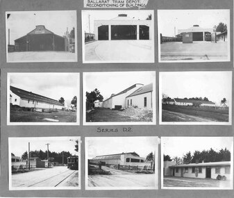
Photograph - Black and White photograph/s - mounted, State Electricity Commission of Victoria (SECV), c1936
... a view taken from the south side of Wendouree Parade... a view taken from the south side of Wendouree Parade. These three ...Demonstrates an aspect and yields information about the reconstruction of the depot during the reconstruction by the SEC of the Ballarat Tramway system.Set of nine black and white prints of the reconditioning of the tramway depot building during 1936 mounted onto a grey light cardboard sheet. Each photo about 65 x 90. Marked as "Series D2" in ink and a label - in on white paper - "Ballarat Tram Depot / Reconditioning of Buildings" at the top of the sheet. Produced by the SEC c1936. See Reg Items 1349 and 1350 for larger prints of these photographs for six of these photographs. The top row of photographs show the depot prior and post to refurbishment and show a view taken from the south side of Wendouree Parade. These three photographs have been scanned at a higher resolution - see 3902i2 - i4. 3902i2 - shows remnants of the triangle connection at the depot? and that the western track may not have been electrified or laid. 390i4 - has trams 30 and 31 out the front of the depot. See In pencil above the photograph of the depot prior to refurbishment - "1934?" trams, tramways, depot, reconstruction, wendouree parade, trackwork, tram 30, tram 31 -
 Ballarat Tramway Museum
Postcard - Folder set, William. F. Scott, Doveton St. and Sturt St, c2000
... in the photograph. Shows buildings along the south side of Sturt St... along the south side of Sturt St. and part of the verandah ...Demonstrates aspects of Ballarat tramway operation with horse tram trailers, - copy of a postcard photograph.B&W print of an ESCo tram just past the intersection of travelling east along the north side of Sturt. Steet towing a heavily laden horse tram as a trailer. Photo appears to be taken soon after opening of the electric trams, as the tram does not have any destination box above the driver. Possibly summer 1905/1906. Numerous people in the street, some horse drawn vehicles in the photograph. Shows buildings along the south side of Sturt St. and part of the verandah of the building at the NE corner of Doveton St. Horse Trailer No. 4 In top of image are the words "Town Hall and Sturt Street, Ballarat" Two copies Larger version than normal, obtained by Bill Scott for publication. For a list and description of the same base image see Archives file - "Notes on ESCo Tram towing a heavily loaded trailer" See Reg Item 4370i1 for a colour postcard.On rear of copy 1, "WFS Collection" in ink and on rear of Copy2 - "William F Scott" address label and "WF Scott collection" in ink.trams, tramways, esco, horse trams, postcards, doveton st, sturt st, tram 8, tram 2 -
 Ballarat Tramway Museum
Slide - 35mm slide/s - set of 13, Noel Simons, 28/04/1971 12:00:00 AM
... along the south side of Sturt St. See also image 1168i1a... along the south side of Sturt St. See also image 1168i1a ...Set of 13 transparencies taken on 28/4/1971 on PAKON mounts. 1168.1 - No. 21 at City terminus - taken from North side of street. Has Boer War statue on right side and National Mutual building in the background. 1168.2 - No. 34 with destination "Sebastopol" in Sturt St., outside Town Hall, with National Mutual building in background. 1168.3 - No. 18 at corner of Sturt and Lydiard Sts with National Mutual building and Craigs Hotel in background. 1168.4 - 18 at intersection of Sturt and Dawson St. 1168.5 - No. 30 at intersection of Armstrong St and Sturt St. with Fletcher Jones building in background. 1168.6 - No. 14 at City Terminus, showing destination of "Victoria St." with Town Hall in the background. 1168.7 - No. 11 bound for Mt Pleasant, opposite Titanic Bandstand in Sturt St. Has a Twin Lakes advertisement on the front dash panel and an unknown roof advertisement. 1168.8 - No. 21 at bottom of Sturt St. approaching the Grenville St. junction, with Dickins Food Store and the Spot Cafe in the background. Tram has destination of "Victoria St". and a roof advertisement for a cigarette? company. 1168.9 - No. 26 and three other trams in City Loop, looking west along Sturt St., just after a heavy hail storm. 1168.10 - No. 21 at the intersection of Sturt St and Dawson St. with Golden City Hotel and the Ritzy Cafe in the background. Can see the Dawson St. crossover track, just after a heavy hail storm. 1168.11 - No. 21 and three other trams at City Loop looking east along the south side of Sturt St. See also image 1168i1a - cleaned up and edited by Peter Waugh April 2024 - used in the April 2024 issue of Fares Please. 1168.12 - No. 14 entering the South side of Sturt St. from Bridge St. with Dickins Store in the background and the Grenville St. shelter alongside the tram. 1168.13 - No. 37 at Sturt and Dawson St., eastbound, showing "Lydiard St. Nth" Has SEC roof advertisement on the side of the tram.1168.1 -"Sturt & Lydiard Sts" 1168.2 - "Town Hall" 1168.3 - "Sturt St & Dawson Sts" 1168.4 - "Sturt and Lydiard Sts" 1168.5 - "Sturt St." 1168.6 - "Sturt and Lydiard Sts" 1168.7 - "Sturt St." 1168.8 - "Bridge St." 1168.9 - "City Loop" 1168.10 -"Dawson & Sturt Sts." 1168.11 - "City Loop" 1168.12 - "Bridge St." All have date stamp of "28 Apr 1971" in purple ink on base. All blue ink unless otherwise noted.tramways, trams, town hall, sturt st., dawson st, armstrong st., grenville st, bridge st., titanic bandstand, tram 11, tram 14, tram 18, tram 21, tram 26, tram 30, tram 34, tram 37 -
 Whitehorse Historical Society Inc.
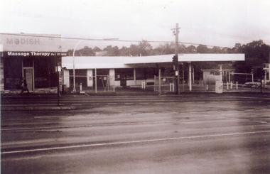
Photograph, Site of new Nunawading ALDI Store, 1/06/2009
... in Springvale Road, Nunawading on the east side and south of the railway... in Springvale Road, Nunawading on the east side and south of the railway ...Black & white photograph of the site of the proposed new Nunawading ALDI store. The site was the former Caltex Service Station in Springvale Road, Nunawading on the east side and south of the railway line.springvale road nunawading, aldi, caltex service station -
 Seaworks Maritime Museum
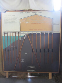
Diagram
... the Yarra river between the 1920s and 1960s. The South Melbourne... along the Yarra river between the 1920s and 1960s. The South ...Cross section of wharves and steel framed sheds built along the Yarra river between the 1920s and 1960s. The South Melbourne side of the Yarra River is reclaimed swamp land. Without a solid foundation for the construction of the wharves and transit sheds, extended piles were sunk into the mud to support the wharf and shed structures. An example of this design may be found at 5 South Wharf which was built in the 1930s. The transit sheds gave shelter for cargo while waiting to be loaded onto a ship or to be collected by truck after being unloaded from a ship. The transit shed became surplus to requirements with the introduction of containers.Wooden diagram of a transit shed featuring a shed sitting atop mud with some water. It shows the splices sitting in the mud to support the shed. "Steel Frames Transit Shed/ 15 South Wharf/ Model of Typical wharf construction/ of 1940- made for the opening of/ the "new" 15 South wharf shed (1944),/ Note the deep piles and elevated/ rear of the shed to allow for the truck/ trays./ This shed feature disappeared/ from port construction with the/ coming of the container era/ reinforced wharf apron/ 3 ton travelling crane/ reinforced concrete shed floor/ concrete road/ water level/ concrete pile cap/ cradled piles/ timber pile splices/ mud/ mild steel pile splices/ 110 ft pile" "On loan from Port of Melbourne Authority" -
 Lake Bolac & District Historical Society
Colour photograph, Lake Bolac township. 1963
... , the large building on the south-east side of the Ballarat road.... Starting centre left, the large building on the south-east side ...Crossroads at Lake Bolac, 1963. Junction of the Ballarat/Hamilton and Ararat/Mortlake roads. Starting centre left, the large building on the south-east side of the Ballarat road is Goodall's garage. Next door is the original Bush Nursing centre, then Dalgety's, the Bakery, the Milkbar and on the corner is the Bank of New South Wales building, Elder's, Green's drapery shop and the Lake Bolac Memorial Hall. On the traffic island in front of the Hall is the War Memorial and across the Woorndoo road is the Hotel (with the maroon roof) with stables behind. Across the road again is the Stanbury's General Store with their large warehouse behind.lake bolac, 1963, goodall, bush nursing, dalgety, elders, green, bank of new south wales, stanbury. -
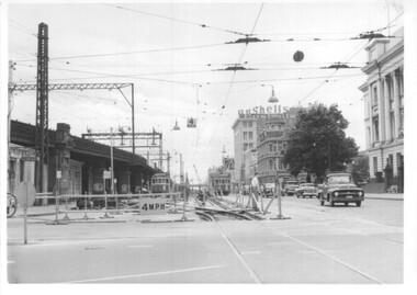 Melbourne Tram Museum
Photograph - Set of 12 - construction of King St overpass in Flinders St, 1959
... prior to the introduction of the temporary tracks on the south... prior to the introduction of the temporary tracks on the south ...Photos show the construction of King St overpass in Flinders St which was part of the project to construct a bridge over the Yarra River and provide a new southern outlet road between the city and eventually St Kilda Junction. The overpass construction was commenced in 1959 with tramway works first commencing. It was demolished in 2005. 1 - looking west at Market St. 2 - looking east from Spencer and Flinders St with the railway viaduct behind. 3 - Tram lines diverted onto the new overpass. Note the hand-powered overhead tower on the left behind the compressor. 4 - Tracks partially diverted. 5 - Looking east at Spencer and Flinders St with a Dunlop tyre truck in the view. 6 - prior to the diversion onto the new bridge. 7 - Looking east near William St. with W2 451 (Route 48, North Balwyn) in the view. 8 - Bridge works near King St. Original tracks still in use. 9 - Looking east prior to the introduction of the temporary tracks on the south side of the new overpass. 10 - SW6 852 and a W2 on new overpass trackwork - old trackwork being demolished. 11 - Cross over at Spencer St in Flinders St, prior to change over. 12 - Looking west at Flinders and Spencer St with SW6 853 turning into Spencer St.Yields information about the construction of the King St overpass in Flinders St during 1959.Set of 12 black and white prints of the construction of the King St overpass in Flinders St.trams, tramways, flinders st, king st overpass, construction, bridges, w2 class, sw6 class, tram 451, tram 853, tram 852 -
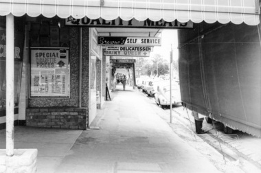 Eltham District Historical Society Inc
Photograph, Shopping centre, Main Road, Eltham, February 1968, Feb 1968
... , looking south along the east side. Includes Browne's Self Service..., looking south along the east side. Includes Browne's Self Service ...Main Road shops from midway between Luck and Pryor Streets, looking south along the east side. Includes Browne's Self Service, Delicatessen, Dairy Queen, Commonwealth Bank, Mac's Meats and Thompson's Chemist.In February 1968 an unknown person took a series of photos from the Eltham Hotel at Pitt Street heading north along Main Road through the shopping centre to just north of Elsa Court covering the length of the section of Main Road which was duplicated shortly thereafter. Shows the condition and environment of the streesscape of Main Road, Eltham immediately prior to the duplication between Pitt Street and Elsa Court through the shopping centre. Also shows a number of shops and businesses that operated at that time.Black and white photographduplication, eltham, main road, shopping centre, thompson's pharmacy, mac's meats, delicatessen, dairy queen, commonwealth bank, browne's self service -
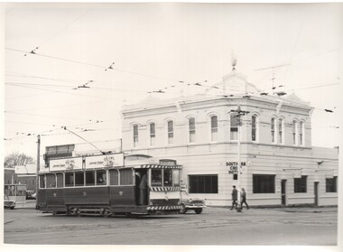 Ballarat Tramway Museum
Photograph - Black & White Photograph/s - set of 5, Charles Craig, 1971
... on the south side. .4 - No. 21 turning into Drummond St south... side. .4 - No. 21 turning into Drummond St south ...Yields information about the intersection of Sturt St and Drummond St and its use by trams in the period before the closure of the SEC system. Shows the Southern Cross Hotel.Set of five Black and White photographs of trams near the intersection of Sturt St and Drummond St South, Hospital Corner. All have the Southern Cross Hotel in the background .1 - No. 31 crosses Drummond St, Gardens via Sturt St West, with two Johnnie Walker Roof adverts. .2 - No. 40 turns from Drummond St South en route to Lydiard St North, while another bogie car waits. Both trams have an electric cooking roof advert. .3 - No. 17 crosses Sturt St with two bogie trams in the view - appears to have been taken before .2. Note the passengers getting off the tram on the south side. .4 - No. 21 turning into Drummond St south, with destination of Sebastopol. Tram has an electric cooking roof advert. .5 - No. 33 crosses Sturt St from Sebastopol while another tram waits at the Sturt St stop. Photo by Charles Craig - during 1971. trams, tramways, sturt st, hospital corner, drummond st sth, tram 31, tram 40, tram 17, tram 21, tram 33 -
 Ballarat Tramway Museum
Postcard, ESCo tram just past the intersection of Doveton St. and Sturt St
... buildings along the south side of Sturt St. and part of the verandah... along the south side of Sturt St. and part of the verandah ...Photographically printed black and white postcard with an impressed image of an ESCo tram just past the intersection of Doveton St. and Sturt St. travelling east along the north side of Sturt. Street towing a heavily laden horse tram as a trailer. Photo appears to be taken soon after opening of the electric trams, as the tram does not have any destination box above the driver. Possibly summer 1905/1906. Numerous people in the street, some horse drawn vehicles in the photograph. Shows buildings along the south side of Sturt St. and part of the verandah of the building at the NE corner of Doveton St. For a list and description of the same base image see Archives file - "Notes on ESCo Tram towing a heavily loaded trailer" On rear is places for correspondences stamp, address. Addressed to Miss E. Freeman, in Dunedin NZ, with a hand written message. Posted in Melbourne on 28/10/1908. Titled "Sturt Street, Ballarat" along bottom edge with "47" in bottom left hand corner of image.. trams, tramways, sturt st, postcards, esco, doveton st -
 Ballarat Tramway Museum
Postcard, Kodak, ESCo crossbench tram No. 19
... on the south side of Sturt. St. Has a number of horse drawn vehicles... building, Snows and other buildings on the south side of Sturt. St ...Printed black and white photographic postcard of Ballarat ESCo crossbench tram No. 19 at the intersection of Armstrong and Sturt St. travelling east along the north side of Sturt Street. Photo appears to be taken in the early days of tram operation - small destination box. Has the Ballarat Town Hall, the National Mutual Life building, Snows and other buildings on the south side of Sturt. St. Has a number of horse drawn vehicles in the image as well. Titled "Sturt Street, Ballarat" in bottom right hand corner". On rear of postcard, printed is the words "Post Card", areas for "Correspondence" and "Address Only" and in stamp area in a square "Kodak Australia" twice. Handwritten on the card is "With Best Wishes for a Happy New Year to all Rostella / W. Lovett". Images .1 - shows postcard, .2 - close up, of No. 19, note Inspector along side tram, the stance of the motorman/driver, and conductor on the rear platform of the tram. Appears to have a destination of "Gardens ?" .3 - rear of postcard Handwritten letter on card.trams, tramways, esco, sturt st, postcards, armstrong st -
 Bendigo Historical Society Inc.
Document - ALBERT RICHARDSON COLLECTION: VICTORIA HILL IRONBARK
... Chum Hill on direct south side of the Calder Highway... as the mining museum. Adjacent to the New Chum Hill on direct south ...Three page document hand written by Albert Richardson, on the history of Victoria Hill, Ironbark. 'one of the richest areas on Bendigo field. In the first six years, £1,200,000 worth of gold was obtained. Almost every claim returned a fortune.' Page three title: Other features on Victoria Hill. 'Adjacent to Central Nell Gwynne area as the mining museum. Adjacent to the New Chum Hill on direct south side of the Calder Highway. This hill reached by a short and excellent access road gives a magnificent view of Bendigo and Golden Square, and a very good view of another tourist attraction, Lansells 'Fortuna' now Survey Regiment's headquarters. This hill is the centre of another rich area. The Lazarus mine 3,360 feet deep with 24 saddle reefs in 2,200 feet. The New Chum United, Lansell's 222with its 120 ft high poppet legs. BCV 8, John Brown Knitwear factory, Esposito's Gold Mines Hotel, Central Nell Gwynne and Manchester tram loops are mentioned.Albert Richardsonbendigo, mining, victoria hill