Showing 1046 items
matching trails
-
 Glen Eira Historical Society
Letter - Rosstown Railway
This file contains four items: 1/A black and white photocopy of a letter dated either 07/08/1889 or 09/08/1889, from Robert Lundon to an unidentified recipient discussing an agreement reached between the author – on behalf of the recipient – and Soon Hang Hi in regard, in regards to the allotment known as Webber’s. The agreement is outlined in the letter in what appears to be Chinese characters, and includes the marks of Robert Lundon and Soon Hang Hi. File note from Joy Wu states that the calligraphy is not Mandarin or traditional Chinese. 2/Three sheets of hand-written working notes with information taken from the Victorian Government Gazette on THE ROSSTOWN AND MURRUMBEENA LAND COMPANY LIMITED, THE ROSSTOWN JUNCTION RAILWAY AND PROSPERITY COMPANY LIOMITED, and THE ROSSTOWN JUNCTION, ELSTERNWICK, AND OAKLEIGH RAILWAY COMPANY LIMITED, covering dates between 1887 and 1894. The notes concern meetings and creditors claims relevant to the companies, with reference numbers for the information source. Date and author of the notes are not recorded. 3/A black and white photocopy of the a partial map of the Rosstown Railway and surrounding area, undated. The map includes the names of landholders in the areas of Brighton, Garden Vale and Elsternwick, as well as other railway lines present in the region. 4/A fold-out map and guide of the Rosstown Rail Trail, including a brief general history of Caulfield as well as a more extensive biography of William Murray Ross and the Rosstown Railway. The map marks and describes significant sites along the trail, including photographs of some of these sites, provided by DF Jowett.documents, correspondence, webber’s, lundon robert, chinese characters, ethnic communities, signatures, text, settlements, taxes, fraser john grieves, lovell r.h., price davies, meetings, communication activities, soon hang hi, commercial events and activities, the rosstown and murrumbeena land company limited, victorian government gazette, bulmer richard, parry john, osment henry, shareholders, creditors claims, the rosstown junction railway and property company limited, finch and best, lawyers, the rosstown junction elsternwick and oakleigh railway company limited, cameron w.c., phillips p.d., garden vale, elsternwick, elsternwick railway station, rosstown, rosstown railway, thomas street, bay street, kooyong road, melbourne and brighton railway, hawthorn road, bambra road, caulfield and frankston railway, booran road, grange road, koornang road, murrumbeena road, north road, north road railway station, east brighton railway station, south road, railway routes, railway lines, railways, land transport, murphy j., caulfield, hamilton t.f., dane p., holloway, webb, ailee john, payne t.b., brodie chas, dane john, o’neil h., mccombie john, mcmillane a., smyth c.d., cooper, ebden, landholders, jeffrey j.d., gill j., balcombe a.e., cooper h., mcnab j., white j., sutherland j., greeves a.f.a., newton m.c., chamley f.b., fowler j., inglis p., grant t., stooke j., swanson g., cochrane c., adams e.b., mccombie thas, keyes robert, brighton cemetery, burials grounds and graveyards, war-ein road, were j.b., holland j., mcmahon c., winter t.l.m., dendy henry, mitchell w., jackson s., were j.e., wickham francis dawe, bryant jane, east brighton railway station, railway stations, maps, allotments, land titles, roads and streets, rosstown rail trail, city of glen eira, tourism, trains, tourism information bureaus, tours, pamphlets, elsternwick railway park, oakleigh junction, princes park, ee gunn reserve, packer park, sites, jowett d.f., weickhardt i.g., return to rosstown: railways land sales and sugar beet ventures in caulfield, land sales, walking trails, ross william murray, transport objects, locomotion, walking, cycling, driving, sports, country mansions, people, caulfield john, builders, construction and demolition workers, occupations, careers, professionals, topography, geology, landforms, horticulture, market gardens, primary industry workers, city of caulfield, mood kee, pennington harold, annual general meetings, caulfield town hall, glen eira city council, carnegie, carnegie station, rosstown station, people by circumstance, migrants, sugar beet, sugar beet mill, sugar beet industry, mills, factories, sea beach lines, bent thomas, parliamentary representatives, neville street, miller street, lemann’s swamp reserve, koornang park, cane sugar industry, breweries, rabbit processing plants, health establishments, hospitals, food production establishments, abattoirs, thieves, social problems, vagrants, theft, squatting, financial economics, debt, finance industry, insurance companies, company managers, bentleigh, ross leila, the grange, leila road, wild cherry road, financial trouble, mortgages, gisborne street, archibald street, riddell parade, victoria railways, glen huntly road, clarence street, college street, gladstone parade, parrell street, aileen avenue, seaview street, drion estate, land subdivisions, dover street, sussex street, landfill, marara road, booran road, woodville avenue, dorothy avenue, ormond park, royal avenue, ormond railway station, oakleigh road, melten avenue, miller street, munro avenue, lord reserve, neerim road, toolambool road, the rosstown hotel, rosanna street, murrumbeena crescent, commercial establishments, the national bank, rosstown road, kangaroo road, poath road, freda street, hughesdale kindergarten, oakleigh council, hughesdale community centre, civic establishments, galbally reserve, plaques, warrigal road, out and about brochures -
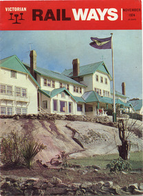 Parks Victoria - Mount Buffalo Chalet
Magazine, "Victorian Railways November 1974"
'Over the years the VR Advertising Division published a number of booklets promoting Mount Buffalo's sports and restorative powers of its scenery in summer and winter...The collection (MBCC) comprises a good range of tourist writing published as promotional booklets, guidebooks, brochures, walking trails, maps and newspaper articles.' (Pg. 119. Historica) This Victorian Railways monthly publication and also the VR Newsletter, published by the Victorian Railways Printing Works in North Melbourne, is one of a number which featured iconic photos of the Chalet of the plateau on its cover, as an identifiable flagship for The Victorian Railways and it's employees from the Railways Refreshment and Services Branch. These publications also have stories regarding upgrades and on long serving staff of the Chalet.Listed in Draft Inventory of Significant Collection Items . Appendix A.3. Promotional material.. (Pg 168. Historica).Railways magazine featuring an image of the chalet on the front cover and an article about the Chalet.Yes -
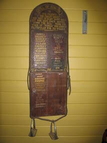 Parks Victoria - Mount Buffalo Chalet
Honour Board
Was located in the stables at Mount Buffalo Chalet. It was used to record the names of horses that were ridden by Chalet guests when they were holidaying at the Chalet. 'Admiring the rugged beauty of the Buffalo Plateau and exploring its scenic attractions ...quickly became part of the Mount Buffalo Chalet tourist experience...The Chalet facilitated the experience by hosting guided tours, including trail rides on horseback...the horses remained at the Chalet for decades, and have been remembered with great affection, as demonstrated by the honour roll for Chalet horses and various commemorative plaques.' (Pg 98. Historica) Many of these horses are still remmbered by former guest of the Chalet. Granite and Punka were legendary and plaques in their honor are mounted on the large granite boulders in the stableyards.Listed in Draft Inventory of Significant Collection items. Appendix A.3, Snow sports equipment and other recreational items. (Pg 166 Historica).Wooden plaque with names painted onto strips of leather fixed to a board. The board is made of two sections of wood and is arched at the top and squared at the base. The piece at the top that appears to be earlier and has gold painted inscriptions with decorative scrolling around the edge. The board has leather strapping around the edge and two stirrups threaded onto leather at the base. The upper section of the board has all the names painted onto leather strips. The lower section of the board has some names painted onto strips but also some names are scratched directly onto the wood.At top of plaque, "ROLL OF HONOUR /TO / OUR FRIENDS - / THE CHALET HORSES, / WHO GAVE US MANY HAPPY HOURS / BUT WHO HAVE SINCE MOVED / "DOWN THE HILL". FROM THE / TIME OF "PUNKA" / WHO SERVED / FAITHFULLY FOR 20 YEARS" Underneat this are the names of the individual horses starting with , "PUNKA....." -
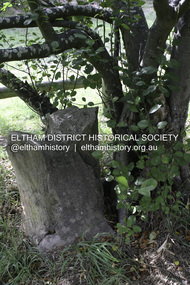 Eltham District Historical Society Inc
Photograph - Digital Photograph, Alan King, Heritage apple tree, 24 January 2008
This old apple tree situated beside the Plenty River Trail at Greensborough has been associated with Melbourne Founder John Batman. The concrete block is inscribed with the date 1841, when the tree was thought to have been planted. Known as Batman's Tree, this apple tree is on the bank of the Plenty River near Leischa Court, Greensborough. It is said that Melbourne Founder John Batman may have planted the tree and later signed his treaty here with the Aboriginal people. It still bears fruit and its recorded on the National Trust's Register of Significant Trees, as the oldest apple tree in Victoria. Published: Nillumbik Now and Then / Marguerite Marshall 2008; photographs Alan King with Marguerite Marshall.; p7This collection of almost 130 photos about places and people within the Shire of Nillumbik, an urban and rural municipality in Melbourne's north, contributes to an understanding of the history of the Shire. Published in 2008 immediately prior to the Black Saturday bushfires of February 7, 2009, it documents sites that were impacted, and in some cases destroyed by the fires. It includes photographs taken especially for the publication, creating a unique time capsule representing the Shire in the early 21st century. It remains the most recent comprehenesive publication devoted to the Shire's history connecting local residents to the past. nillumbik now and then (marshall-king) collection, greensborough, john batman tree, plenty river trail -
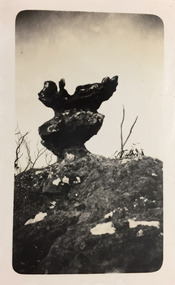 Kew Historical Society Inc
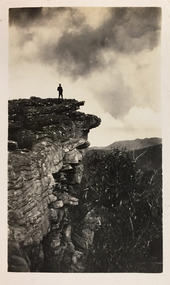
Photograph - Grampians, 1924
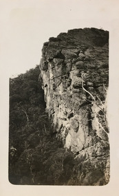
Henry Beater Christian (1886-1962) , was a descendant of one of the earliest settler families in Kew. Employed at the Kew Asylum as a 'public servant', he was a skilled amateur photographer, photographing numerous scenes in Kew and on his travels around Victoria. The majority of his photographs date from 1916 to 1929. His finest photographs are housed in two photograph albums. Digital copy of a photograph from page 12 of the 47-page photograph album containing 261 gelatinous silver images, loaned by Diane Washfold with permission given to digitise and hold a copy in our collection. The first and last pages in the album document the Yarra River at Studley Park and at Kew. The remainder of the album includes photographs of walking and car tours in rural Victoria including 'wilderness' areas in the Grampians, Gippsland and the High Country. Six album pages document a camping trip by Henry Christian to the Grampians in September 1924. The photos include pictures of lookouts, and natural features including rock faces and waterfalls, as well as his camp site. This photo is of a self-standing rock on what is probably the Mt Victory trail. "Mt Victory / Grampians / 9.24"henry beater christian (1886-1962), landscape photography, christian-washfold collection, photograph albums, grampians, mt victory, gariwerd -
 Kew Historical Society Inc
Photograph - Grampians, 1924
Henry Beater Christian (1886-1962) , was a descendant of one of the earliest settler families in Kew. Employed at the Kew Asylum as a 'public servant', he was a skilled amateur photographer, photographing numerous scenes in Kew and on his travels around Victoria. The majority of his photographs date from 1916 to 1929. His finest photographs are housed in two photograph albums. Digital copy of a photograph from page 13 of the 47-page photograph album containing 261 gelatinous silver images, loaned by Diane Washfold with permission given to digitise and hold a copy in our collection. The first and last pages in the album document the Yarra River at Studley Park and at Kew. The remainder of the album includes photographs of walking and car tours in rural Victoria including 'wilderness' areas in the Grampians, Gippsland and the High Country. Six album pages document a camping trip by Henry Christian to the Grampians in September 1924. The photos include pictures of lookouts, and natural features including rock faces and waterfalls, as well as his camp site. This photo is of one of a well-known cliff face on one of the walking trails. Unitled [Grampians]henry beater christian (1886-1962), landscape photography, christian-washfold collection, photograph albums, grampians, mt victory, gariwerd -
 Kew Historical Society Inc
Photograph - Grampians, 1924
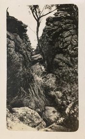
Henry Beater Christian (1886-1962) , was a descendant of one of the earliest settler families in Kew. Employed at the Kew Asylum as a 'public servant', he was a skilled amateur photographer, photographing numerous scenes in Kew and on his travels around Victoria. The majority of his photographs date from 1916 to 1929. His finest photographs are housed in two photograph albums. Digital copy of a photograph from page 13 of the 47-page photograph album containing 261 gelatinous silver images, loaned by Diane Washfold with permission given to digitise and hold a copy in our collection. The first and last pages in the album document the Yarra River at Studley Park and at Kew. The remainder of the album includes photographs of walking and car tours in rural Victoria including 'wilderness' areas in the Grampians, Gippsland and the High Country. Six album pages document a camping trip by Henry Christian to the Grampians in September 1924. The photos include pictures of lookouts, and natural features including rock faces and waterfalls, as well as his camp site. This photo is of one of opposing rock faces on one of the walking trails. Unitled [Grampians]henry beater christian (1886-1962), landscape photography, christian-washfold collection, photograph albums, grampians, gariwerd -
 Bendigo Historical Society Inc.
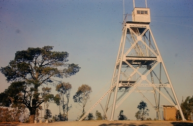
Slide - Peter Ellis Collection, Kaweka Wildflower Reserve, Castlemaine, Lightning Hill Lookout Bendigo, One Tree Hill Lookout Tower Bendigo, Kamarooka Forest Area, c1970-1972
Kaweka Reserve is a a small reserve of approximately 8ha. The land was donated to the Castlemaine City to be a wildflower Reserve. A management committee was formed in 1966. The committee is still managing the park. Vicroads Edition 6: Map 59E2, 628 H4 Location. Turner St, Castlemaine. From the Castlemaine Post Office, drive north (towards Bendigo) and turn right along Turner Street to the park entrance. What to do: walk along some of the tracks through the park follow the nature trail bird watch have a picnic at the picnic tables. RUSH Dam is a basic free camping area sits alongside Rush Dam in the Greater Bendigo National Park, featuring a single picnic table and wood fire barbecue.Peter Ellis Collection: Seventeen slides of Kaweka Wildflower Reserve, Castlemaine, Lightning Hill Lookout Bendigo, One Tree Hill Lookout Tower Bendigo. Also the Rush Dam free camping area at Kamarooka. Also a slide of an unknown group having a meal or day out; perhaps also a working bee. In addition there are two slides of a house - location not specified; and a working bee clearing along a pipeline at Big Hill. Peter was a chemistry lecturer at the Bendigo Institute of technology.history, bendigo, peter ellis collection, whipstick bendigo, bendigo state forests, kaweka wildflower reserve castlemaine, one tree hill lookout bendigo, lightning hill lookout bendigo, kamarooka, rush dam kamarooka, greater bendigo national park -
 Greensborough Historical Society
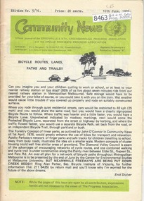
Newsletter, Greenhills and North Greensborough Progress Association, Community News: official journal of the Greenhills and Nth. Greensborough Progress Association and the Apollo Parkways Progress Association.10th June,1976. Edition No. 5/76, 10/06/1976
This edition includes a report on the The Apollo Parkways Progress Association's May1976 meeting, Bicycle routes, lanes, paths and trails, Thoughts from young cyclists, It can happen to you [youth deaths on our roads], Lament for a traffic statistic, Returning to study, I can do it too!!, This and that, Cameo of Les James, How does the working mum cope?, From the O'Donnells, Diminishing community spirit?, School news, Greenhills basketball, Scout and Guide news, Nursing Mothers Association. Supplement to "Community News". No. 6/76. Diamond Valley Shire: South-East Councillors' report, From the Chamber Council, Art and craft survey, Letter to the Editor. A digital copy of this Newsletter is available from Greensborough Historical Society. Newsletter, 24 p., illus.greenhills and north greensborough progress association, greenhills, apollo parkways progress association, apollo parkways -
 The Beechworth Burke Museum
Photograph - Lantern Slide, c1900
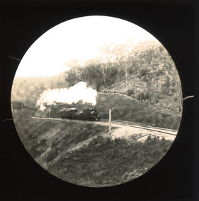
This slide shows a train proceeding along the Beechworth rail trail in approximately 1900. The rail line to Beechworth was the subject of significant lobbying by local officials such as John Orr and G.B. Kerferd in the 1860s, as it was recognised that the poor quality of roads to Melbourne and Albury hindered trade and formed a barrier to the social development of the town. The subsequent positioning of Beechworth on a branch rather than a main line was not considered ideal to achieve these aims, but the Everton-to-Beechworth and Beechworth-to-Yackandandah components of the line cost an average of £7,277 per mile and State Government officials felt the need in the area did not justify the cost of a direct line. The Beechworth Railway Station was officially opened on the 29th of September 1876 and ran services twice daily to Melbourne, transporting nearly 12,000 passengers and around 6,500 tons of cargo in 1900. It closed in 1976 and is today used as a cycling trail used by locals and promoted as a feature of the area to tourists. Lantern slides, sometimes called 'magic lantern' slides, are glass plates on which an image has been secured for the purpose of projection. Glass slides were etched or hand-painted for this purpose from the Eighteenth Century but the process became more popular and accessible to the public with the development of photographic-emulsion slides used with a 'Magic Lantern' device in the mid-Nineteenth Century. Photographic lantern slides comprise a double-negative emulsion layer (forming a positive image) between thin glass plates that are bound together. A number of processes existed to form and bind the emulsion layer to the base plate, including the albumen, wet plate collodion, gelatine dry plate and Woodburytype techniques. Lantern slides and magic lantern technologies are seen as foundational precursors to the development of modern photography and film-making techniques.This glass slide is significant because it provides insight into Beechworth's social amenities and transport infrastructure in the late Nineteenth Century. It is also an example of an early photographic and film-making technology in use in regional Victoria in the time period.Thin translucent sheet of glass with a circular image printed on the front and framed in a black backing. It is held together by metal strips to secure the edges of the slide.burke museum, beechworth, lantern slide, slide, glass slide, plate, burke museum collection, photograph, monochrome, indigo shire, north-east victoria, rail trail, beechworth rail trail, beechworth station, everton, wangaratta, wodonga, albury, rail transport, cargo transport, g.b. kerferd, john orr, murray to mountains rail trail, cycling, biking, railway -
 Federation University Historical Collection
Documents - Reports, Paul Cropper, Myths & Monsters Conference Papers, 10/2001
The Myths and Monsters conference was something of a landmark in Australian mystery animal research. It was the first cryptozoological conference held in Australia, and the first time Australia's leading researchers had been able to present their findings and meet with others working in the same field. 82 page proceedings of the Myths and Monsters Conference printed onto white paper. The following topics were presented: * A brief History of Australian Cryptozoology (Paul Cropper) * Would the Real Orang-Utan Please Stand Up and be Counted? In search of unidentified relic hominoids in Southeast Asia (Helmut Loofs-Wissowa) * Strange Creatures on the Antipodean UFO trail (Bill Chalker) * The Bunyip (Gary Opit) * Sightings of Some Anomolous Sea Creatures (Malcolm Smith) * Investigating Cryptic Hominids (Yowies) in the Blue Mountains of New South Wales (MIchael Hallett & David McBean) * "High Strangeness" in Yowie Reports (Tony Healy) * The Mystery of the Australian Big Cat: A Brief Summary (Peter Chapple) * Quest for the Thylacine (Peter Chapple) [Australian Animal Folklore Collection]Signed on cover "Simon Townsend"australian animal folklore collection, paul cropper, ruby lang, helmut loofs wissowa, bill chalker, gary opit, malcolm smith, michael hallett, david mcbean, tony healy, peter chapple, bunyip, blue montains, yowie, thylacine, big cat, puma, panther, ufo, goolma, woodenbong, narrabeen lakes, cecil mcgann, dorothy middleton, lee kelly, brown bittern, bay monster, simon moir, footprints, blue mountains cryptid, prehistoric bipedal primates, gigantopithecus, meganthropus, homo rudolfensis, homo habilis, homo erectus, homo ergaster, hominid, bigfoot, psychic phenomena, black panther, lake monster, blue labyrinth, australian rare fauna research association, marsupial lion, thylocoleo carnifex, australian big cat, tasmanian devil, sarcophilus harrisi, eric guiler, yellingbo, thylacinus cynocephalus, tantanoola tiger, rilla martin, mundrabilla, predatory animal, mythical, myth, folklore -
 Bendigo Historical Society Inc.
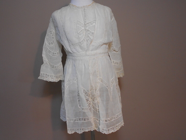
Clothing - CHILD'S CREAM COLOURED WAISTED ORGANZA DRESS
Clothing. Child's cream coloured waisted organza dress. U shaped neckline with 1.5 cm lace trim with eyelet edge. Silk ribbon (1cm) threaded through eyelet lace. Organza fabric and bows. Large bow pattern of on centre front of bodice, on each sleeve and four bows around skirt connected with trailing ribbon pattern. Front bodice has decorative vertical pin tucks.Back bodice has vertical pin stripes and lace strip inserts. Centre back opening (35 cm) fastened with ribbon at neckline and five metal hooks with cotton loops. Two horizontal strips of lace around waistline. Long straight sleeves trimmed with 1.5 cm lace at wrist. Hem is trimmed with 1.5 cm lace. Dress is unlined.costume, children's, child's cream coloured linen petticoat -
 Bendigo Historical Society Inc.
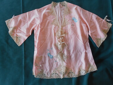
Clothing - FAVALORO COLLECTION: WOMAN'S BED JACKET, 1950's
Clothing. Pink silk woman's bed jacket with set in short sleeves. Sleeves are trimmed with inverted V shape coffee coloured lace edging and a bow of 1cm double sided ribbon of pink and light green. Front opening with V neckline. Neckline edges of front opening and hemline trimmed with inverted V shape coffee coloured lace (7cm deep). Front fastened below neck line with double bow of double sided 1 cm ribbon in pink and light green. Embroidered patterns of blue flowers with pink trailing vines and leaves at the top front LHS below the shoulder and lower front RHS above the hem. Small triangular lace pocket on lower front RHS trimmed with bow of double sided 1cm ribbon.Tag on lower inside seam, ''Made by Grace Bros Ltd. Broadway, Sydney''.costume, female, woman's bed jacket -
 Ballarat Tramway Museum
Magazine, State Electricity Commission of Victoria (SECV), "History of the Ballarat Tramways", Feb. 1939
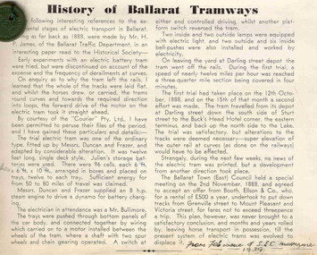
Magazine cutting contained within Reg. Item 2488, page 31, titled "History of the Ballarat Tramways" from the Feb. 1939 issue of the "SEC Magazine". Report on a recent paper by H.P. James to the Historical Society about the experimental battery tram in Ballarat in October 1888. Notes that Duncan and Fraser input into the Julien Battery experiment, Mr. Bullimore the electrician and trails and problems with the track. Also has notes regarding tramways in Ballarat East Township. Accompanying the item are handwritten notes about the tramcar used and its fate. Attached in the top left hand corner of the item, sewn in, is a green ESCo 2d token. (See Reg item 1794 and 1943 for details and other samples) Note Item Not formally Numbered. Image btm2494i2 shows position on page relative to items 2494 to 2504Numerous on page 31 in ink and penciltrams, tramways, battery tram, duncan & fraser, trials, ballarat east, esco -
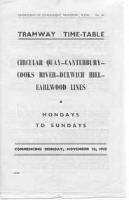 Ballarat Tramway Museum
Ephemera - Timetable, Dept of Government Transport - NSW, Sydney Tramway Timetable - 1953 Sydney, 1953 and 1954
Paper - black and white. Alterations on separate pieces of paper in the book - 5 pages. 120.1 - Tramway timetable for Circular Quay - Canterbury - Cooks Rivers - Dulwich Hill - Earlwood lines, 1953. 120.2 - Altered journey for route, Circular Quay - Cooks River line - 1954 120.3 - Altered journey - Dulwich Hill, Glebe Point, Balmain, Lilyfield and Darling St. wharf - Canterbury lines - 1954. 120.4 - Altered journey (on trail) Circular Quay and Darling St. wharf and Canterbury lines - 1954. 120.5 - Additional and altered journeys - Circular Quay and Darling St. wharf lines - 1954 120.6 - Tram time table for Circular Quay - North Bondi line (via Bellevue Hill) including running times, sections and fares - July 26 1954.sydney, timetables -
 Kew Historical Society Inc
Photograph - Grampians, 1924
Henry Beater Christian (1886-1962) , was a descendant of one of the earliest settler families in Kew. Employed at the Kew Asylum as a 'public servant', he was a skilled amateur photographer, photographing numerous scenes in Kew and on his travels around Victoria. The majority of his photographs date from 1916 to 1929. His finest photographs are housed in two photograph albums. Digital copy of a photograph from page 12 of the 47-page photograph album containing 261 gelatinous silver images, loaned by Diane Washfold with permission given to digitise and hold a copy in our collection. The first and last pages in the album document the Yarra River at Studley Park and at Kew. The remainder of the album includes photographs of walking and car tours in rural Victoria including 'wilderness' areas in the Grampians, Gippsland and the High Country. Six album pages document a camping trip by Henry Christian to the Grampians in September 1924. The photos include pictures of lookouts, and natural features including rock faces and waterfalls, as well as his camp site. This photo is of a man, perhaps Henry Christian, standing on one of the lookouts on what is probably the Mt Victory trail. "Mt Victory / Grampians / 9.24"henry beater christian (1886-1962), landscape photography, christian-washfold collection, photograph albums, grampians, mt victory, gariwerd -
 Melbourne Tram Museum
Slide - Set of 4, John Webster, 14/12/1959 12:00:00 AM
Set of four Colour slides, Kodak, white cardboard, .4 brown cardboard of trams using the Flinders St overpass of King St, 14-12-1959 .1 - SW6 854 at the top of the new bridge. .2 - SW6 854 at the bottom of the new bridge, has destination of Hawthorn route 27, and adverts for Biro pens, Lindeman's sherry, Knights Jewellery and KSP ? .3 - SW6 854 trailing photo with William St, nearing the intersection with William St. with the Yarra Family Hotel and a shop selling Oysters and Crayfish. .4 - Photo showing a W2 and W5? climbing the bridge. Note the overhead has been set up for a junction. In the background are adverts for Penfolds Wines, Bushels, the Flinders St viaduct, Nestles Milk, Girlings, Barrow Bros, Store.Hand writing on rear in ink; .1 - 14-12-59 - KFL2 - Flinders St flyover, Melbourne Vic. .2 - 14-12-59 - KFL2a - Trams coming over the Flinders St flyover, Melbourne Vic. .3 - 14-12-59 - KFL3 - temporary track during building of the Flinders St flyover, Melbourne. .4 - 14-12-59 - KFL3a - Flinders St flyover, Melbourne Vic.trams, tramways, trackwork, flinders st, king st, track construction, bridges, sw6 class, hawthorn, route 27, tram 854 -
 Eltham District Historical Society Inc
Photograph, Heidelberg Artists Trail sign, "Landscape with Sheep" Walter Withers, Wingrove Park, Eltham, c.May 2001
The Heidelberg School Artists Trail was established in about 1999 with about 52 signs across four local governemnt areas including Nillumbik and Banyule. This one acknowledges "Landscape with Sheep" by Walter Withers. The text on the board states: Walter Withers depicts in this work a number of sheep on Mr. Tom Orr’s property. Our view is from the rise above this park, from the Lower Plenty side of the nearby Diamond Creek, looking northwards towards the main Eltham township. The area that is now Wingrove Park, would have been to the right, in the valley below the sheep. The mood of this work is warm and vibrant, with the use of strong blues and pinks, and this stands in marked contrast to the softer, cooler greens used by Walter Withers in his work ‘The Silent Gums’.Roll of 35mm colour negative film, 7 stripsAgfa HDC 200 plus-2eltham, heidelberg artists' trail, wingrove park trail, landscape with sheep, walter withers -
 Stawell Historical Society Inc
Memorabilia - Realia, Semco Embroidery Text Book 3D !st Edition Free Sampler insede, 1930's
Published by Semco Art Needlework Pty.Ltd> Semco Park Cheltenham Road Black Rock S.9. Farrow Falcon Press Pty. Ltd. 226 Lonsdale Place, Melbourne. For Girls learning embroidery- home/schoolSemco Embroidery Text Book. White outline around Black cover. Large red circle with girl siting in front doing embroidery wearing Victorian style short puffed sleeved dress polka dot pattern and pantaloons red stockings and lace up ballerina style shoes1st Edition Semco Embroidery Text Book 3D Free sampler transfer inside. Booklet contains illustrations and instructions for each stich. Pages 2 and 3 have pencil squiggles across the top.: Stem stitch, Snail Trail, Back Stitch, Lazy Daisy Stitch, Thousand Flower Stitch, Buttonhole Stitch, Long and short buttonhole stitch, Chain Stitch Seed Stitch, Arrow stitch, Feather Stitch, Herringbone Stitch, Cross Stitch, French Knots, Lattice Stitch. Illustrations of designs with stiches referred to on previous pages. stawell -
 Eltham District Historical Society Inc
Photograph, Fay Bridge, Remains of apple orchard near the Diamond Creek, Wattle Glen, 11 October 2018
The newly constructed Diamond Creek Trail from Diamond Creek to Wattle Glen completed in February 2021 winds past these apple trees that possibly lined the entrance to the Greenhills property From Jean Verso, Nillumbik Historical Society, 15 April 2021 William Wandless Herbert bought the surrounding 100 acres in 1852. He was a native of Northumberland and the Scottish Borders who arrived in Melbourne in 1847. The house on the top of the mound would have been built not long after he bought the land; the farm was named "Greenhills". He married Elizabeth Wilson, daughter of John Wilson who had been in Diamond Creek since about 1846. Their first child was born in 1854 so there would be some form of dwelling from about that time. They had eight children who all survived to a good age. His will describes the house as part stone and part wood and of four rooms. Nillumbik Historical Society (NHS) believe it was one of the earliest if not the earliest house, in this part of the district. The remains of the stone house foundations are on top of the mound (photos on the VHD page) and the barn walls are on the north and to the east side of the mound. NHS is not sure how much or which part of the surrounding area was covered by the barns but they were large enough to hold dances after the race meetings that were held in the late 1880's on the adjacent creek flats. It would make sense with the lay of the land that they covered some of the ground to the north and east and used for farm storage, packing sheds for their apple and pear orchards and also for supporting the Nillumbik Gold Mine the family worked to the north up the gully. The path that comes down the gully and runs into the trail goes past the mine site which was on the west side of the gully a couple of hundred metres up from the flats. Heritage Victoria link for the site - https://vhd.heritagecouncil.vic.gov.au/places/12203fay bridge collection, 2018-10-11, diamond creek, diamond creek trail, elizabeth wilson, greenhills, wattle glen, william wandless herbert, apple trees -
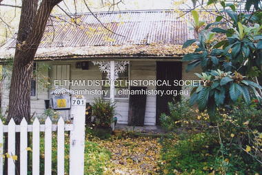 Eltham District Historical Society Inc
Photograph, Fay Bridge, Former Jarrold Cottage and Bootmaker's Shop, 701 Main Road, Eltham, n.d
Situated originally on the corner of the Dalton Street road reserve west of Main Road (now present-day Wingrove Park Trail), the former Jarrold Cottage (White Cloud) was purchased by Lena Skipper following Thekla Jarrold's death in 1943. It was built by William Jarrold in the early 1850s and was here that he married Hannah Coleman in 1856. The Bootmaker's shop was built by Thekla Jarrold in 1930 for use by her friend, John Clark, a local photographer who had boarded with the Jarrold family since about 1910. In 1930 he changed profession to a bootmaker and leather worker. The shop is one of only three remaining early 20th century shops in what was Little Eltham, the others being present-day San Antionio Barber Shop at 820 Main Road and Cafe Zen Den at 736 Main Road.fay bridge collection, bootmaker's shop, eltham, jarrold cottage, main road, shops, white cloud cottage, wingrove park trail -
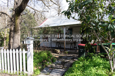 Eltham District Historical Society Inc
Photograph, Peter Pidgeon, White Cloud Cottage, 701 Main Road, Eltham, 2 Aug. 2022
Situated originally on the corner of the Dalton Street road reserve west of Main Road (now present-day Wingrove Park Trail), the former Jarrold Cottage (White Cloud) was purchased by Lena Skipper following Thekla Jarrold's death in 1943. It was built by William Jarrold in the early 1850s and was here that he married Hannah Coleman in 1856. The Bootmaker's shop was built by Thekla Jarrold in 1930 for use by her friend, John Clark, a local photographer who had boarded with the Jarrold family since about 1910. In 1930 he changed profession to a bootmaker and leather worker. The shop is one of only three remaining early 20th century shops in what was Little Eltham, the others being present-day San Antionio Barber Shop at 820 Main Road and Cafe Zen Den at 736 Main Road.Born Digitaleltham, main road, bootmaker's shop, jarrold cottage, white cloud cottage, shops, wingrove park trail -
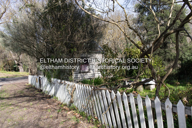 Eltham District Historical Society Inc
Photograph, Peter Pidgeon, Former Bootmaker's shop, 701 Main Road, Eltham, 2 Aug. 2022
Situated originally on the corner of the Dalton Street road reserve west of Main Road (now present-day Wingrove Park Trail), the former Jarrold Cottage (White Cloud) was purchased by Lena Skipper following Thekla Jarrold's death in 1943. It was built by William Jarrold in the early 1850s and was here that he married Hannah Coleman in 1856. The Bootmaker's shop was built by Thekla Jarrold in 1930 for use by her friend, John Clark, a local photographer who had boarded with the Jarrold family since about 1910. In 1930 he changed profession to a bootmaker and leather worker. The shop is one of only three remaining early 20th century shops in what was Little Eltham, the others being present-day San Antionio Barber Shop at 820 Main Road and Cafe Zen Den at 736 Main Road.Born Digitaleltham, main road, bootmaker's shop, jarrold cottage, white cloud cottage, shops, wingrove park trail -
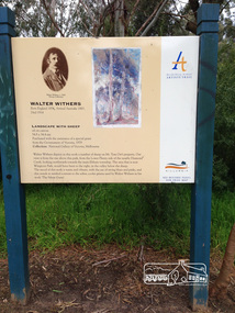
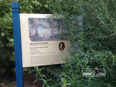 Eltham District Historical Society Inc
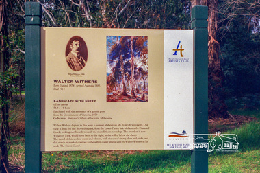
Photograph, Peter Pidgeon, Heidelberg Artists Trail signs are through this area including local artist Walter Withers, 2 Sep 2017
The Heidelberg School Artists Trail was established in about 1999 with about 52 signs across four local governemnt areas including Nillumbik and Banyule. This one located in Wingrove Park Eltham pays tribute to Walter Withers and his painting "The Silent Guns" Transcription of sign: Walter Withers – The Silent Gums, 1909 Walter Withers painted this tranquil pastoral scene in the vicinity this park. Here he has captured the dairy cattle belonging to local Eltham farmer, Mr. Tom Orr, feeding and resting in the shade of the tall Manna gums. Wither’s daughter, Nan recalled how her father, for inspiration, often visited the property of their neighbour, Mr. Tom Orr, and in his later years, Withers painted many landscapes depicting Mr Orr’s sheep and dairy cattle. Heritage Excursion by EDHS Members - An Eltham South Ramble, 2 Sep 2017Born Digitalactivities, eltham district historical society, eltham south, heritage excursion, local history centre, walter withers, heidelberg artists' trail, wingrove park trail, the silent gums -
 Eltham District Historical Society Inc
Photograph, Peter Pidgeon, Landscape with sheep by Walter Withers part of the Heidelberg Artist Trail, 2 Sep 2017
The Heidelberg School Artists Trail was established in about 1999 with about 52 signs across four local governemnt areas including Nillumbik and Banyule. This one acknowledges "Landscape with Sheep" by Walter Withers. The text on the board states: Walter Withers depicts in this work a number of sheep on Mr. Tom Orr’s property. Our view is from the rise above this park, from the Lower Plenty side of the nearby Diamond Creek, looking northwards towards the main Eltham township. The area that is now Wingrove Park, would have been to the right, in the valley below the sheep. The mood of this work is warm and vibrant, with the use of strong blues and pinks, and this stands in marked contrast to the softer, cooler greens used by Walter Withers in his work ‘The Silent Gums’. Heritage Excursion by EDHS members - An Eltham South Ramble, 2 Sep 2017Born Digitalactivities, eltham district historical society, eltham south, heritage excursion, local history centre, eltham, heidelberg artists' trail, walter withers, landscape with sheep, wingrove park trail -
 Ballarat Tramway Museum
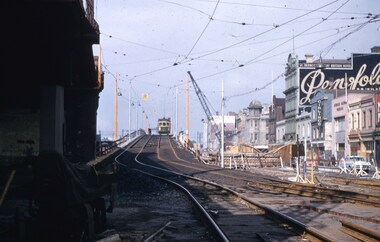
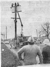
Newspaper, The Courier Ballarat, "Tram change uneventful", 24/08/1971 12:00:00 AM
Newspaper clipping pasted onto a single sheet of paper with two Punch holes on the left hand side with one hole through the photograph within the cutting. Clipping from The Courier, Ballarat, 24/8/1971, about the first stage of Ballarat's changeover from trams to buses passes uneventfully yesterday with only minor difficulties being reported. Quotes Transport Regulation Boards Regional Office, Mr. A. Stott, a few parking problems with cars in bus bays, demand for timetables. Also has a quote from the director of Davis Bus Lines, about minor problems - passengers asking questions. Has a photograph of the SEC linesman dismantling overhead in Victoria St., as a trail. A gang from Melbourne will come to Ballarat early in September to pull down all the lines. Newspaper cutting published on the Tuesday. 2nd copy added 14/11/2002In red ink in upper right hand corner, "24/8/71" On sheet of paper, various pencil markings - with date Dec. 1963. Possibly paper used by Donor at his job with the former machinery makers, Ronaldson and Tippet.trams, tramways, closure, bus changeover, overhead, dismantling -
 Kew Historical Society Inc
Photograph - Grampians, 1924
Henry Beater Christian (1886-1962) , was a descendant of one of the earliest settler families in Kew. Employed at the Kew Asylum as a 'public servant', he was a skilled amateur photographer, photographing numerous scenes in Kew and on his travels around Victoria. The majority of his photographs date from 1916 to 1929. His finest photographs are housed in two photograph albums. Digital copy of a photograph from page 12 of the 47-page photograph album containing 261 gelatinous silver images, loaned by Diane Washfold with permission given to digitise and hold a copy in our collection. The first and last pages in the album document the Yarra River at Studley Park and at Kew. The remainder of the album includes photographs of walking and car tours in rural Victoria including 'wilderness' areas in the Grampians, Gippsland and the High Country. Six album pages document a camping trip by Henry Christian to the Grampians in September 1924. The photos include pictures of lookouts, and natural features including rock faces and waterfalls, as well as his camp site. This photo is of a man, perhaps Henry Christian, holding his camera while standing on one of the lookouts on what is probably the Mt Victory trail. The photo was framed in a circle during the development process. "Mt Victory / Grampians / 9.24"henry beater christian (1886-1962), landscape photography, christian-washfold collection, photograph albums, grampians, mt victory, gariwerd -
 Kew Historical Society Inc
Photograph - High Street, Kew, 1960-65
The borders of the main components of Kew and Kew East have not always conformed to current boundaries. In the past this photograph has been labelled as East Kew, whereas for most of the twentieth century the site has been within Kew's borders. The purpose of the photograph is unrecorded yet it has value in that it shows those businesses who occupied this site in Kew during the early 1960s.This small photograph is significant as it shows the location of and building used by WD Vaughan, former Mayor of Kew who was a successful newspaper proprietor in Melbourne.Small polaroid colour positive of High Street in Kew, probably in the 1960s. From left we can see the brick viaduct covering the tracks of what was once the Outer Circle Railway. Behind this brick wall, Dunnings Timber Yard was situated. At the end of the walls of the viaduct there is an entrance to a walkway [now the Anniversary Trail], which once provided access to Windsor Avenue, and also to the East Kew Station (now demolished and part of the Outer Circle Railway Reserve). On the other side of this walkway is a cream brick building (demolished) occupied at this time by WD Vaughan Pty Ltd, printer and publisher of the Kew Advertiser (newspaper). Stretching behind the brick facade is an extensive building that must have housed the printing works. Beside Vaughan's, there is a large building (demolished) housing at that time an estate agent named AJ Kennedy. This area is now separated by kerbing.High St East Kew / Corner of Harp Rd. / Looking South -
 Eltham District Historical Society Inc
Photograph - Digital Photograph, Alan King, Sign: Clara Southern, Heidelberg School Artists Trail, Main Road, Research, 2008
Warrandyte artist, Clara Southern, features on the Artists Trail. Published: Nillumbik Now and Then / Marguerite Marshall 2008; photographs Alan King with Marguerite Marshall.; p189 Since early in the 20th century this district has attracted artists and other creative people. So much so, that Eltham has been compared to the Left Bank in Paris, New York’s Greenwich Village and London’s Bloomsbury. That is until the 1970s when Eltham rapidly expanded into a suburb. However many artists still flourish not only in Montsalvat, Dunmoochin and the Bend of Islands but elsewhere in Nillumbik. Some artists who have worked or lived in Nillumbik are well-known nationally and internationally. Artists are attracted to the hilly district’s subtle colours, unique light and the Yarra River and Diamond Creek. The railway’s extension to Eltham in 1902 brought artists to paint for the day or to camp. Then many settled in Eltham, perhaps also because the poor quality land, far from the city, was cheap. Following World War Two they found they could build houses and studios cheaply by making their own mud-bricks. The flexible material, with its warm tones blending into the bush, also satisfied their aesthetic sensibilities. As early as 1900, Will Longstaff, known for his painting The Ghosts of Menin Gate at the National War Memorial in Canberra, lived at Stanhope in Peter Street, Eltham, later to become the home of intellectuals Clem and Nina Christensen. Members of Australia’s first significant art movement, the Heidelberg School of Artists, painted in Eltham, Warrandyte and Diamond Creek. Walter Withers lived at the corner of Bolton and Brougham Street, Eltham and taught Sir Hans Heysen, who for a short while stayed with the Withers family. In Warrandyte were Clara Southern, whom Frederick McCubbin taught at the National Gallery School and Penleigh Boyd, who is represented in all Australian state galleries and the National Collection in Canberra. May Vale, daughter of politician William, lived in Diamond Creek. With Jane Price they feature on the Heidelberg School Artists Trail, part of which runs through Nillumbik. The trail includes signs each displaying a reproduction of a painting by an artist and located near where the artist lived or painted. In Nillumbik the trail includes parts of Warrandyte, Eltham in the Alistair Knox Park, Main Road shopping precinct and Wingrove Park, the Research walking track on Main Road and the Diamond Creek Reserve. In 1916 artist William ‘Jock’ Frater lived at the corner of Arthur and Bible Streets, Eltham. Before then, Frater, with other artists including Percy Leason (who moved to Eltham in the mid 1920s) painted in Eltham on weekends. They camped near Bible and Pitt Streets and along the Diamond Creek where the Eltham Retirement Centre now stands.4 In 1921, painter Peter Newbury (father to painter David Newbury, who was born in Eltham) moved to Cromwell Street, Eltham. Max Meldrum, the first Australian painter to formulate a consistent theory of art largely based on tone,5 taught local artists Alan Martin, Clarice Beckett, Peter Glass and Justus Jörgensen. Meldrum visited Eltham then rented a house there for 18 months opposite Wingrove Park. In 1934, artist and architect Justus Jörgensen and his doctor wife Lil and friends built Montsalvat, the artists’ colony. Montsalvat has played an important part in attracting artists to Eltham and its mud-brick, pisé, stone and recycled building materials has had a major influence on Eltham’s built environment. Jörgensen’s students who also helped him build Monstalvat included Arthur Munday, Lesley Sinclair, Helen Lempriere, Joe Hannan, Helen, Sonia and jeweller/sculptor, Matcham Skipper. Among artists who visited Montsalvat were Clifton Pugh and Angry Penguins’ artists Albert Tucker and Arthur Boyd. Some who painted after World War Two were Alan Martin of Eltham and Warrandyte artists Frank Crozier and Harry De Hartog6, one of Melbourne’s first painters influenced by Cubism.This collection of almost 130 photos about places and people within the Shire of Nillumbik, an urban and rural municipality in Melbourne's north, contributes to an understanding of the history of the Shire. Published in 2008 immediately prior to the Black Saturday bushfires of February 7, 2009, it documents sites that were impacted, and in some cases destroyed by the fires. It includes photographs taken especially for the publication, creating a unique time capsule representing the Shire in the early 21st century. It remains the most recent comprehenesive publication devoted to the Shire's history connecting local residents to the past. nillumbik now and then (marshall-king) collection, clara southern, main road, research (vic), heidelberg school artists trail -
 Eltham District Historical Society Inc
Photograph, Fay Bridge, Ruins beside the Diamond Creek at Wattle Glen, 13 October 2016
The newly constructed Diamond Creek Trail from Diamond Creek to Wattle Glen completed in February 2021 winds around these ruins just pass the high transmission power lines near Herberts Lane and Collard Drive From Jean Verso, Nillumbik Historical Society, 15 April 2021 William Wandless Herbert bought the surrounding 100 acres in 1852. He was a native of Northumberland and the Scottish Borders who arrived in Melbourne in 1847. The house on the top of the mound would have been built not long after he bought the land; the farm was named "Greenhills". He married Elizabeth Wilson, daughter of John Wilson who had been in Diamond Creek since about 1846. Their first child was born in 1854 so there would be some form of dwelling from about that time. They had eight children who all survived to a good age. His will describes the house as part stone and part wood and of four rooms. Nillumbik Historical Society (NHS) believe it was one of the earliest if not the earliest house, in this part of the district. The remains of the stone house foundations are on top of the mound (photos on the VHD page) and the barn walls are on the north and to the east side of the mound. NHS is not sure how much or which part of the surrounding area was covered by the barns but they were large enough to hold dances after the race meetings that were held in the late 1880's on the adjacent creek flats. It would make sense with the lay of the land that they covered some of the ground to the north and east and used for farm storage, packing sheds for their apple and pear orchards and also for supporting the Nillumbik Gold Mine the family worked to the north up the gully. The path that comes down the gully and runs into the trail goes past the mine site which was on the west side of the gully a couple of hundred metres up from the flats. Heritage Victoria link for the site - https://vhd.heritagecouncil.vic.gov.au/places/12203fay bridge collection, 2016-10-13, diamond creek, diamond creek trail, ruins, wattle glen, william wandless herbert, greenhills, elizabeth wilson