Showing 560 items
matching west creek
-
 Bendigo Historical Society Inc.
Document - BOARD OF WORKS, MELBOURNE: CONTRACTS ACCEPTED & LAND SALES FOR 1860
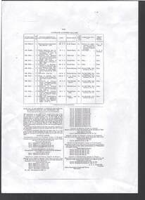
Page 2223 titled Contracts Accepted - (Series 1860). Contracts accepted are for Raising and removing sunken ship Marilla; Removal of Toll-gate from Mount Alexander Road and re-erection of same at Middle Gully; Erection of toll-house on Melbourne/Ballarat Road near Ballan; Erection of toll-house on Bendigo Road at Kangaroo Flat; Castlemaine to Ballarat - Erection of toll-house at Campbell's Creek; Construction of 2870 chains of Lower Western Road, west of Camperdown; Erection of two bridges and other improvements on the Clunes to Amherst Road; Erection of timber bridge, & c., over Two-mile Creek - Beechworth to Bowman Forest; Formation of roadway at head of Buckland Gap - Beechworth to Bowman Forest; Construction of culvert, & c., Rowe's Creek - Beechworth to Bowman Forest; Ararat and South-western sea-board road - erection of bridge over Dennicull Creek and other improvements. Land Sales - 4 Lots - Elsternwick, parish of Prahran, County of Bourke; 2 Lots - Dandenong, County of Bourke; 20 Lots - Lillydale, Parish of Yering, County of Evelyn, 1 suburban Lot - County of Evelyn, Parish of Yering; 1 Allotment - Romsey, County of Bourke, Parish of Lancefield; 5 Lots - County of Mornington, Parish of Langwarrin, and 2 Lots - County of Mornington, Parish of Fingal. Lots to be sold at the Auction Rooms of Mr. William Perry, Great Collins Street, Melbourne. A F A Greaves, President, Office of the Board of Land and Works, Melbourne.bridge, construction, timber bridges, board of works, melbourne - contracts accepted & land sales, 'marilla', f m pingree, jno r bailey, robert heron, john gray, donald ross, hector mclean, c j glynn and co, john nicholls and co, michael cleary, thomas cairncross, brown and gibson, queen victoria, mr william perry, mr de castella, willoughby, barker, a f a greeves, board of land and works melbourne -
 Bayside Gallery - Bayside City Council Art & Heritage Collection
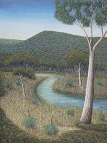
Painting - oil and acrylic on canvas, Robert Kelly, Chinaman's Creek, 2016
Bob Kelly paints landscapes of culturally significant sites along the Mornington Peninsula and depicts these locations as he imagines they originally were before colonisation. Using traditional Western painting techniques, Kelly records the underlying spirit of the Peninsula from a Wathaurong perspective. Chinaman’s Creek in Capel Sound (Rosebud West) was an important watercourse that originally ran from Wonga (Arthur’s Seat) down through Tootgarook Swamp into Port Phillip Bay. It was a great fresh water and food source and home for many Boonwurrung people. Since settlement over 170 years ago, the creek has been drained, blocked, reconstructed and damaged. Kelly depicts a lush green landscape in which the clean creek water winds through the surrounding vegetation of spinifex grasses and gum trees, the background hills are abundant with trees, untouched from man's intervention. Using painstaking detail, Kelly records each blade of grass and ripple on the surface of Chinaman’s Creek. His attention to detail serves to powerfully reimagine this important cultural site, returning it to its former pristine state, and reinvigorating its role as a key place of sustenance for the Indigenous populations of the Peninsula. Chinaman's Creek was a finalist in the 2017 Bayside Acquisitive Art Prize.oil and acrylic on canvaslandscape, creek, trees, chinaman's creek, painting, indigenous, robert kelly, bayside acquisitive art prize, bob kelly, wathaurong, rosebud, arthur's seat, tootgarook swamp, port phillip bay, boonwurrung -
 Bendigo Historical Society Inc.
Document - LYDIA CHANCELLOR COLLECTION: BENDIGO METHODIST CHURCHES PLAN 1905 AND CHURCH OFFICIALS, 1905
LYDIA CHANCELLOR COLLECTION: Bendigo Methodist Churches Plan 1905 and church officials Quarterly Pastoral Visitation of Classes Circuit plan for Forest St, Golden square, Eaglehawk West, Eaglehawk East, California Hill, California Gully, Long Gully, McKenzie St, Galvin St, Rowan St, Arnold St, Iron Bark, Buckly St, Specimen Hill, Quarry Hill, Bridge St, Retreat Road, Kangaroo Flat, Lockwood, East Shelbourne, White Hills, Epsom, Huntly, Bagshot, fosterville, Strathfieldsaye, Axe Creek, sheepwash, Nerring, Leichardt, Leichardt East, Marong, Golden Fleece, Golden Gully, Dowling St Mission, Benevolent Asylum, Hospital Income and Expenditure List of stewards Notices Pastorates Evangelistic Bandsbendigo, history, schooling -
 Ararat Gallery TAMA
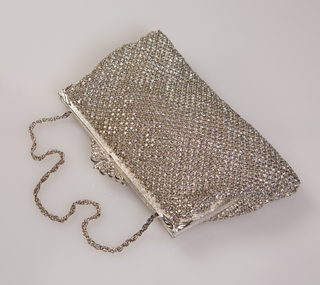
Clothing, Carmen, West Germany, Evening Bag
The Lady Barbara Grimwade Costume Collection is comprised of Lady Barbara Grimwade's personal apparel and includes 145 pieces of clothing, 10 hats, 19 handbags, 66 pairs of shoes and assorted accessories of gloves, belts and scarves. In its breadth, this significant acquisition ranges from the mundane to the memorable, therefore giving a balanced representation of one person's taste. Following Lady Barbara Grimwade’s death in March 1990, Ararat Gallery formally accepted the generous gift of clothing and accessories donated by Lady Grimwade's son, Mr Angus K Grimwade, on 28 August 1991. Subsequent smaller donations in 1995 enhanced the collection. Lady Grimwade's Scottish forebears, the Gaerloch Campbells, first settled in Australia in 1861 in the Ararat-Beaufort district. Her great great grandfather, Mr Henry Campbell, died on the voyage to Australia. His widow, Jane, with 10 of her 13 children, farmed and grazed land, firstly at Stockyard Hill then at Fiery Creek, near Buangor, before leaving the shire in 1873. Lady Grimwade held a privileged position in Melbourne society. As the wife of Sir Andrew Grimwade, a prominent businessman, Chairman of several boards and a Trustee of various committees, Lady Grimwade met with royalty, heads of state, politicians, corporate directors, and horse and cattle breeders. Excerpt from 'Hot Pink Summers' catalogue essay, Helen Jackson, 1995. -
![Junction of the River Watt and Contentment Creek / [by] Nicholas Caire, circa 1876](/media/collectors/550653872162f11fb04854aa/items/57760437d0cdd10a5c49fc3e/item-media/57760510d0cdd10a5c4a8f9c/item-fit-380x285.jpg) Kew Historical Society Inc
Kew Historical Society IncPhotograph, Anglo-Australasian Photographic Company, Junction of the River Watt and Contentment Creek, c. 1876
Nicholas Caire was born on Guernsey in the Channel Islands in 1837. He arrived in Adelaide with his parents in about 1860. In 1867, following photographic journeys in Gippsland, he opened a studio in Adelaide. From 1870 to 1876 he lived and worked in Talbot in Central Victoria. In 1876 he purchased T. F. Chuck's studios in the Royal Arcade Melbourne. In 1885, following the introduction of dry plate photography, he began a series of landscape series, which were commercially successful. As a photographer, he travelled extensively through Victoria, photographing places few of his contemporaries had previously seen. He died in 1918. Reference: Jack Cato, 'Caire, Nicholas John (1837–1918)', Australian Dictionary of Biography.An original, rare photograph from the series 'Views of Victoria: General Series' by the photographer, Nicholas Caire (1837-1918). The series of 60 photographs that comprise the series was issued c. 1876 and reinforced a neo-Romantic view of the Australian landscape to which a growing nationalist movement would respond. Nicholas Caire was active as a photographer in Australia from 1858 until his death in 1918. His vision of the Australian bush and pioneer life had a counterpart in the works of Henry Lawson and other nationalist poets, authors and painters.Albumen Silver Photograph, mounted on Board. printed in ink on support l.c.: JUNCTION OF THE RIVER WATT AND CONTENTMENT CREEK. / COPYRIGHT REGISTERED. printed in ink on support reverse c.: VIEWS OF VICTORIA. / (GENERAL SERIES.) / No. 1. / JUNCTION OF THE RIVER WATT AND CONTENTMENT CREEK. / This scene is situated about two miles to the westward of Fernshawe, a small but extremely romantic township. / The river, at this juncture, is crossed by a fallen tree, as may be seen in the illustration. The track which is seen on / the opposite side of the river leads to the summit of Mt. Munda (3,500 feet high), 4 miles distant, from which place / visitors can see the Australian Alps, in all their mighty grandeur, stretching for hundreds of miles on either side, / and, as far as the eye can reach, impressing a beholder with the appropriateness of their title, being that of the Great Dividing Range. printed in ink on support reverse l.c.l.: J.W. FORBES, Agent, printed in ink on support reverse l.c.: ANGLO-AUSTRALASIAN PHOTOGRAPHIC COMPANY, MELBOURNE. printed in ink on support reverse l.c.r.: 10 Temple Court, Collins Street West.nicholas caire, views of victoria - general series, landscape photography -
![Junction of the Rivers Yarra and Watt, Near Healesville / [by] Nicholas Caire, circa 1876](/media/collectors/550653872162f11fb04854aa/items/577740e5d0cdd10a5c0de011/item-media/57774153d0cdd10a5c0e0662/item-fit-380x285.jpg) Kew Historical Society Inc
Kew Historical Society IncPhotograph, Anglo-Australasian Photographic Company, Junction of the Rivers Yarra and Watt, Near Healesville, c. 1876
Nicholas Caire was born on Guernsey in the Channel Islands in 1837. He arrived in Adelaide with his parents in about 1860. In 1867, following photographic journeys in Gippsland, he opened a studio in Adelaide. From 1870 to 1876 he lived and worked in Talbot in Central Victoria. In 1876 he purchased T. F. Chuck's studios in the Royal Arcade Melbourne. In 1885, following the introduction of dry plate photography, he began a series of landscape series, which were commercially successful. As a photographer, he travelled extensively through Victoria, photographing places few of his contemporaries had previously seen. He died in 1918. Reference: Jack Cato, 'Caire, Nicholas John (1837–1918)', Australian Dictionary of Biography.An original, rare photograph from the series 'Views of Victoria: General Series' by the photographer, Nicholas Caire (1837-1918). The series of 60 photographs that comprise the series was issued c. 1876 and reinforced a neo-Romantic view of the Australian landscape to which a growing nationalist movement would respond. Nicholas Caire was active as a photographer in Australia from 1858 until his death in 1918. His vision of the Australian bush and pioneer life had a counterpart in the works of Henry Lawson and other nationalist poets, authors and painters.Albumen Silver Photograph, mounted on Board.printed in ink on support l.c.: JUNCTION OF THE RIVERS YARRA AND WATT, NEAR HEALESVILLE. / COPYRIGHT REGISTERED. printed in ink on support reverse c.: VIEWS OF VICTORIA. / (GENERAL SERIES.) / No. 3. / JUNCTION OF THE RIVERS YARRA AND WATT, NEAR HEALESVILLE / The junction is situated about 3 miles from Healesville, and 35 miles from the mouth of the Yarra. The souces / of the Watt are to be found at the head of the Black Spur, and, being fed by a number of creeks and springs, its / waters gain considerable force for several miles before joining those of the Yarra. The "Old Bridge," at the junction, / is the name given to this crossing-place, which has been partly swept away by late floods. The depth of the Yarra here / is from 15 to 20 feet; that of the Watt, about 10 feet. printed in ink on support reverse l.c.l.: J.W. FORBES, Agent, printed in ink on support reverse l.c.: ANGLO-AUSTRALASIAN PHOTOGRAPHIC COMPANY, MELBOURNE. printed in ink on support reverse l.c.r.: 10 Temple Court, Collins Street West.nicholas caire (1837-1918), yarra river, watt river, bridge, wooden bridge, healesville -
![State School, Fernshawe / [by] Nicholas Caire, circa 1876](/media/collectors/550653872162f11fb04854aa/items/5777443dd0cdd10a5c0fa4c9/item-media/57774498d0cdd10a5c0fd7bf/item-fit-380x285.jpg) Kew Historical Society Inc
Kew Historical Society IncPhotograph, State School, Fernshawe, c. 1876
Nicholas Caire was born on Guernsey in the Channel Islands in 1837. He arrived in Adelaide with his parents in about 1860. In 1867, following photographic journeys in Gippsland, he opened a studio in Adelaide. From 1870 to 1876 he lived and worked in Talbot in Central Victoria. In 1876 he purchased T. F. Chuck's studios in the Royal Arcade Melbourne. In 1885, following the introduction of dry plate photography, he began a series of landscape series, which were commercially successful. As a photographer, he travelled extensively through Victoria, photographing places few of his contemporaries had previously seen. He died in 1918. Reference: Jack Cato, 'Caire, Nicholas John (1837–1918)', Australian Dictionary of Biography.An original, rare photograph from the series 'Views of Victoria: General Series' by the photographer, Nicholas Caire (1837-1918). The series of 60 photographs that comprise the series was issued c. 1876 and reinforced a neo-Romantic view of the Australian landscape to which a growing nationalist movement would respond. Nicholas Caire was active as a photographer in Australia from 1858 until his death in 1918. His vision of the Australian bush and pioneer life had a counterpart in the works of Henry Lawson and other nationalist poets, authors and painters.Albumen Silver Photograph mounted on boardprinted in ink on support l.c.: STATE SCHOOL, FERNSHAWE. / COPYRIGHT REGISTERED. printed in ink on support reverse c.: VIEWS OF VICTORIA. / (GENERAL SERIES.) / No. 5. / STATE SCHOOL, FERNSHAWE. / This educational institution occupies one of the most romantic situations of any of the State Schools in Victoria. / On either side of it runs a river and a creek, whilst immediately surrounding it are a great many large fern trees. / The background comprises many giants of the forest. In the centre of the picture stands a stump, about 60 feet / high, which has evidently been struck by lightning. The neighbourhood, not being a very populous one, furnishes / but 30 children for educational training. printed in ink on support reverse l.c.l.: J.W. FORBES, Agent, printed in ink on support reverse l.c.: ANGLO-AUSTRALASIAN PHOTOGRAPHIC COMPANY, MELBOURNE printed in ink on support reverse l.c.r.: 10 Temple Court, Collins Street West.nicholas caire (1837-1918), landscape photography -
![Giant fern trees: Splitters' Track, Black Spur / [by] Nicholas Caire, circa 1876](/media/collectors/550653872162f11fb04854aa/items/57774978d0cdd10a5c123cdb/item-media/57774a0fd0cdd10a5c1297aa/item-fit-380x285.jpg) Kew Historical Society Inc
Kew Historical Society IncPhotograph, Anglo-Australasian Photographic Company, Giant fern trees: Splitters' Track, Black Spur, c. 1876
Nicholas Caire was born on Guernsey in the Channel Islands in 1837. He arrived in Adelaide with his parents in about 1860. In 1867, following photographic journeys in Gippsland, he opened a studio in Adelaide. From 1870 to 1876 he lived and worked in Talbot in Central Victoria. In 1876 he purchased T. F. Chuck's studios in the Royal Arcade Melbourne. In 1885, following the introduction of dry plate photography, he began a series of landscape series, which were commercially successful. As a photographer, he travelled extensively through Victoria, photographing places few of his contemporaries had previously seen. He died in 1918. Reference: Jack Cato, 'Caire, Nicholas John (1837–1918)', Australian Dictionary of Biography.An original, rare photograph from the series 'Views of Victoria: General Series' by the photographer, Nicholas Caire (1837-1918). The series of 60 photographs that comprise the series was issued c. 1876 and reinforced a neo-Romantic view of the Australian landscape to which a growing nationalist movement would respond. Nicholas Caire was active as a photographer in Australia from 1858 until his death in 1918. His vision of the Australian bush and pioneer life had a counterpart in the works of Henry Lawson and other nationalist poets, authors and painters.Albumen silver photograph mounted on boardprinted in ink on support l.c.: GIANT FERN TREES: SPLITTERS' TRACK, BLACK SPUR. / COPYRIGHT REGISTERED. printed in ink (vertically) on support reverse u.c.l.: J.W. FORBES, Agent, printed in ink (vertically) on support reverse c.l.: ANGLO-AUSTRALASIAN PHOTOGRAPHIC COMPANY, MELBOURNE. printed in ink (vertically) on support reverse c.: VIEWS OF VICTORIA. / (GENERAL SERIES.) / No. 8. / GIANT FERN TREES: SPLITTERS' TRACK, BLACK SPUR. / The scene which this illustration represents is situated on Morley's Creek, at the foot of the Black Spur, and is / about a mile and a half from the Township of Fernshawe. The Fern Trees in this locality are of gigantic growth, / measuring 50 feet in height, the fronds of which are from 12 to 15 feet long. This excessive growth is attributable / to the great number of springs flowing into the creek, thereby causing the surrounding soil to be in a continual / state of moisture. printed in ink (vertically) on support reverse l.c.l.: 10 Temple Court, Collins Street West.landscape photography, nicholas caire, black spur - victoria -
![Scene near Corranderrk Station / [by] Nicholas Caire, circa 1876](/media/collectors/550653872162f11fb04854aa/items/57774ae0d0cdd10a5c12f2d7/item-media/57774b61d0cdd10a5c132dac/item-fit-380x285.jpg) Kew Historical Society Inc
Kew Historical Society IncPhotograph, Anglo-Australasian Photographic Company, Scene near Corranderrk Station, c. 1876
Nicholas Caire was born on Guernsey in the Channel Islands in 1837. He arrived in Adelaide with his parents in about 1860. In 1867, following photographic journeys in Gippsland, he opened a studio in Adelaide. From 1870 to 1876 he lived and worked in Talbot in Central Victoria. In 1876 he purchased T. F. Chuck's studios in the Royal Arcade Melbourne. In 1885, following the introduction of dry plate photography, he began a series of landscape series, which were commercially successful. As a photographer, he travelled extensively through Victoria, photographing places few of his contemporaries had previously seen. He died in 1918. Reference: Jack Cato, 'Caire, Nicholas John (1837–1918)', Australian Dictionary of Biography. The 1860s marked the beginning of the era of reserves and missions. Six Aboriginal reserves were established during the 1860s. These were under the control of the Board for the Protection of Aborigines. Four were Christian missions receiving government aid. These were Lake Tyers (Anglican) and Ramahyuck (Presbyterian/Moravian) in eastern Victoria for the Gunai/Kurnai clans; Ebenezer (Moravian) in north-west Victoria for the clans of the Wimmera and Lower Murray; and Lake Condah (Anglican) in south-west Victoria. The other two were secular government controlled reserves: Framlingham which, like Lake Condah, was established for the Mara-speaking Gunditjmara and Kirrae-wurrung people of south-west Victoria; and Coranderrk, located about 60 kilometres north-east of Melbourne, for the Kulin clans of central Victoria. In 1863, after a period of devastation to the Kulin people, Coranderrk was established at the junction of the Yarra River and Badger Creek. Reference: http://coranderrk.com/, accessed 24 December 2016An original, rare photograph from the series 'Views of Victoria: General Series' by the photographer, Nicholas Caire (1837-1918). The series of 60 photographs that comprise the series was issued c. 1876 and reinforced a neo-Romantic view of the Australian landscape to which a growing nationalist movement would respond. Nicholas Caire was active as a photographer in Australia from 1858 until his death in 1918. His vision of the Australian bush and pioneer life had a counterpart in the works of Henry Lawson and other nationalist poets, authors and painters.Albumen silver photograph mounted on boardprinted in ink on support l.c.: SCENE NEAR "CORRANDERRK" STATION. / COPYRIGHT REGISTERED. printed in ink on support reverse c.: VIEWS OF VICTORIA. / (GENERAL SERIES.) / No. 9. / SCENE NEAR "CORRANDERRK" STATION. / This scene was taken from the hill near Rourke's Bridge, on the Healesville Road, and displays in the foreground / the River Yarra. The roadway which is seen in the mid-distance has lately been constructed by the Government, / as the old tracks which formerly existed, were liable to be swamped by the periodical overflowing of the River. Mount / Ridell can be seen in the extreme distance immediately behind the roadway. / Corranderrk is the local habitation / for the natives of this district, and is situated on the right hand side of the picture, about a mile and a half / from the roadway. printed in ink on support reverse l.c.l.: J.W. FORBES, Agent, printed in ink on support reverse l.c.: ANGLO-AUSTRALASIAN PHOTOGRAPHIC COMPANY, MELBOURNE. printed in ink on support reverse l.c.r.: 10 Temple Court, Collins Street West.nicholas caire (1837-1918), coranderrk aboriginal station, aborigine, yarra river, badger creek, first peoples, aboriginal and torres straight islander -
![Roadway Scene on the Black Spur / [by] Nicholas Caire, circa 1876](/media/collectors/550653872162f11fb04854aa/items/577759b7d0cdd10a5c1a5d0a/item-media/57775a11d0cdd10a5c1aab42/item-fit-380x285.jpg) Kew Historical Society Inc
Kew Historical Society IncPhotograph, Anglo-Australasian Photographic Company, Roadway Scene on the Black Spur, c.1876
Nicholas Caire was born on Guernsey in the Channel Islands in 1837. He arrived in Adelaide with his parents in about 1860. In 1867, following photographic journeys in Gippsland, he opened a studio in Adelaide. From 1870 to 1876 he lived and worked in Talbot in Central Victoria. In 1876 he purchased T. F. Chuck's studios in the Royal Arcade Melbourne. In 1885, following the introduction of dry plate photography, he began a series of landscape series, which were commercially successful. As a photographer, he travelled extensively through Victoria, photographing places few of his contemporaries had previously seen. He died in 1918. Reference: Jack Cato, 'Caire, Nicholas John (1837–1918)', Australian Dictionary of BiographyAn original, rare photograph from the series 'Views of Victoria: General Series' by the photographer, Nicholas Caire (1837-1918). The series of 60 photographs that comprise the series was issued c. 1876 and reinforced a neo-Romantic view of the Australian landscape to which a growing nationalist movement would respond. Nicholas Caire was active as a photographer in Australia from 1858 until his death in 1918. His vision of the Australian bush and pioneer life had a counterpart in the works of Henry Lawson and other nationalist poets, authors and painters.Albumen silver photograph mounted on boardprinted in ink on support l.c.: ROADWAY SCENE ON THE BLACK SPUR. / COPYRIGHT REGISTERED printed in ink (vertically) on support reverse u.c.l.: J.W. FORBES, Agent, printed in ink (vertically) on support reverse c.l.: ANGLO-AUSTRALASIAN PHOTOGRAPHIC COMPANY, MELBOURNE. printed in ink (vertically) on support reverse c.: VIEWS OF VICTORIA. / (GENERAL SERIES.) / No. 18. / ROADWAY SCENE ON THE BLACK SPUR. / The road which is represented in this illustration has lately been constructed by the Government at considerable / expense. It is three miles in length from the base to the summit, some portions of which are very steep. Mails / are conveyed by Cobb & Co.'s Coaches to Marysville and Woodspoint via this route daily. The scenery on the Black / Spur, and beyond as far as Myrtle Creek, is exceedinly picturesque. printed in ink (vertically) on support reverse l.c.l.: 10 Temple Court, Collins Street West.nicholas caire (1837-1918), landscape photography, black spur - victoria -
 Kew Historical Society Inc
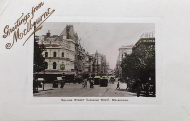
Postcard, Collins Street (looking West), Melbourne, 1907-1914
The Kew Historical Society's postcard collection includes views of Kew, Melbourne and Greater Melbourne as well as those including overseas scenes sent or received from Europe or the Middle East. They date from the 1890s to the 2000s. These postcards may or may not include the name of the publisher or printer. A number of the cards were published as parts of popular series. A way of dating early postcards is to identify whether the reverse was divided by a central line which became the norm after 1902 in the United Kingdom. However, other postcards produced after this date do not always conform to this print layout.Early postcard of MelbourneSepia tinted postcard of Collins Street, Melbourne, Th postcard design includes a line separating the address from the message on the reverse, which dates it after 1902. The stamp on the card is a red Victorian stamp with the head of Queen Victoria in use 1901-1911.Front title - Collins Street (looking West), Melbourne Reverse. - Mrs Garahy, Creek Parade, Clunes, Vic / Dear Mollie / All join with me in wishing you and our dear mother a very prosperous and happy New Year. I am enjoying my holidays very much. I heard Melba last week and went to the pantomime Humpty Dumpty. - it was all lovely. I’ll tell you all about them when I return to Clunes. We were all home for Xmas Day. The first time for 17 years. Fondest love. N.C. / I cut my right hand very badly last Monday and have not been able to write till today. N.C.postcards -- melbourne (vic.), collins street --- melbourne (vic) -
 Kew Historical Society Inc
Map, MMBW, MMBW Plan No.64 Kew & Heidelberg, 1900-1910
The Melbourne and Metropolitan Board of Works (MMBW) was established by an act of the Victorian Parliament in 1890 to prepare for and to implement a sewerage and water reticulation system across what was then inner Melbourne, its surrounding and middle distance suburbs, including Kew. The MMBW was disbanded in 1991.The map collection of the Kew Historical Society has at its core the historic maps assembled and originally stored in the City Engineer's Department of the City of Kew. These include maps in a number of scales. The vast majority of maps were produced by the MMBW in the first two decades of the twentieth century, and are solid working maps, backed by linen for durability. These maps are historically significant to Kew, the City of Boroondara and to the history of the development of state utilities in Victoria. A number of the Kew maps have additional details added by former municipal officers, including the levels reached by various floods. As these were working documents, information was added to them long after the period of their initial production and distribution.Early map of part of the Borough of Kew, created in the first decade of the twentieth century, at a scale 160 ft to 1 inch. The map covers what was then the northern most part of Kew, bordered on its north and west by the Yarra River, in the East by Connor's Creek and by the Asylum in the south. The map shows the extent of urban development by that time, prominent institutions and the outlines of built structures in the municipality. Contour lines and historic flood levels were added in ink to the map at a later stage.MELBOURNE AND METROPOLITAN BOARD OF WORKS / PLAN NO. 64 / KEW & HEIDELBERGmelbourne & metropolitan board of works, mmbw maps, mmbw plans, borough of kew, cartography -
 Kew Historical Society Inc
Map, MMBW, MMBW Plan No.68 Kew, 1900-1910
The Melbourne and Metropolitan Board of Works (MMBW) was established by an act of the Victorian Parliament in 1890 to prepare for and to implement a sewerage and water reticulation system across what was then inner Melbourne, its surrounding and middle distance suburbs, including Kew. The MMBW was disbanded in 1991.The map collection of the Kew Historical Society has at its core the historic maps assembled and originally stored in the City Engineer's Department of the City of Kew. These include maps in a number of scales. The vast majority of maps were produced by the MMBW in the first two decades of the twentieth century, and are solid working maps, backed by linen for durability. These maps are historically significant to Kew, the City of Boroondara and to the history of the development of state utilities in Victoria. A number of the Kew maps have additional details added by former municipal officers, including the levels reached by various floods. As these were working documents, information was added to them long after the period of their initial production and distribution.Early map of part of the Borough of Kew, created in the first decade of the twentieth century, at a scale 160 ft to 1 inch. The map covers what was then the north central part of Kew, bordered in the north by Oak Avenue, in the west by the Yarra River and Connor's Creek, in the south by Beresford and Carnegie Avenues, and in the east by Glass's Creek and Burke Road. The map shows the extent of urban development by that time, prominent institutions and the outlines of built structures in the municipality. Contour lines and the levels of historic floods were added in ink to the map at a later stage.MELBOURNE AND METROPOLITAN BOARD OF WORKS / PLAN NO. 68 / KEW melbourne & metropolitan board of works, mmbw maps, mmbw plans, borough of kew, cartography -
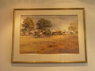 Friends of Westgarthtown
Painting, John Borrack, Last Days Ziebells "The Pines" Thomastown
Painted from the home (or front) paddock which ran south to the creek. The paddock was used for the cultivation of lucerne and maize crops in the lower regions while closer to the house where Ainwick Crescent is now situated, it was a burgeoning market garden for the cultivation of all varieties of vegetables. The large pines beyond, sheltered the farmyard on the west of Gardenia Road. That complex can be partly glimpsed on the left of the painting. This is a directly painted watercolour relying on the use of white paper and transparencies to impart a feeling of morning light. The figure is the artist's mother for whom the picture was painted. Provenance: Augusta Borrack (nee Ziebell) Collection, John Borrack CollectionWatercolour painting, depicting Ziebell's Farmhouse from the south (Thomastown and Mernda). Painting is mounted in a gold frame with cream board.Artist signature: John Borrack; Last Days at Ziebells "The Pines" Thomastown, 'Pro mea matre hanc picturan feci (In Memoria)'illustrations, watercolours, john borrack, ziebell, watercolour, painting -
 Brimbank City Council Art Collection
Photograph, Robert Pointon, West Bank of the Kororoit Creek looking north, 1988
... Scene Huntsman Chemical works, West Bank of the Kororoit Creek ...Local SceneHuntsman Chemical works, West Bank of the Kororoit Creek looking north - AR0019 -
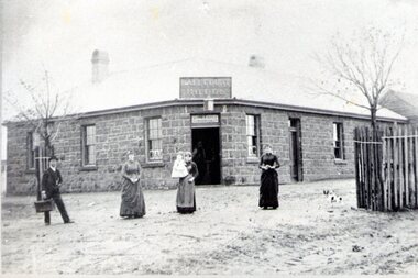 Sunbury Family History and Heritage Society Inc.
Photograph, Ball Court Hotel
The hotel was built some time shortly after 1842 by John Cahill, who arrived in the colony in 1842 from Thurles in Tipperary, Ireland. The building although much altered with render covering the original \blue stone structure is on the south-west corner of Macedon and Jackson Streets. The hotel was called the Ball Court because Cahill also had a hand-ball court set up behind the hotel.Originally five hotels were built along Macedon Street between Jackson Creek and Evans Street. The Ball Court Hotel is the only one still standing and operating as a hotel.A non-digital black and white photograph with a cream border of man and three ladies standing outside a single story blue stone hotel building with a corner entrance. AS well as the corner entrance there is another doorway on the RHS along with three narrow windows and three other windows on the other side. One of the ladies is holding a little child. Two trees surrounded by tree guards are on each side of the photograph.Ball Court Hotel, John Cahillball court hotel, hotels, sunbury, macedon street, jackson street, ball court -
 Sunbury Family History and Heritage Society Inc.
Photograph, Bulla Bridge
A coloured photograph of the bluestone bridge which spans Deep Creek at Bulla. The photograph is taken facing upstream. The bridge was constructed in 1869 and replaced a ford crossing further downstream. Many bridges in the South West of Victoria were constructed from Bluestone basalt rock because the area is on a large volcanic plain and that rock is in abundance. A coloured photograph of the Bulla Bridge which spans the Deep Creek at Bulla. Photograph 0178 is an identical photograph tho this one.bridges, bulla bridge -
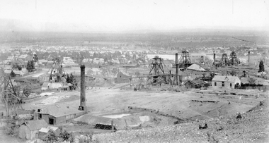 Stawell Historical Society Inc
Photograph, Panorama Of Stawell from Big Hill looking North West 1878 Mines Visible
On very left behind the winding engine shed in the foreground is the South Cross Mines No8 & No9. The next mine to the right not counting the Whims is the Crown Cross United Mine with curved tramway. Tyne Reefing Company is barely visible at centre of image in front of left end of settling dam. The Great Northern is centre right of image, Extended Cross Reef Mine, then Oriental Mine, the Grant Lamont Battery and two Pleasant Creek Cross Reef Poppet Heads.Scotchmans United Quarts Mining Company 1878Victorian Views. C. Herbert, Photo. Stawell 1878stawell mining -
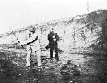 Surrey Hills Historical Society Collection
Photograph, Surrey Hills Golf Club - the cutting in (now) Whitehorse Road, 1905, 1905
Reproduced by permission of Mr John Arnold from his book: "The Riversdale Golf Club - a history, 1892-1977." Copyright to book: Riversdale Golf Club. Surrey Hills Golf Club operated from 1892-1908 then moved and became Riversdale Golf Club. The game was played across paddocks from Trafalgar Street, Mont Albert to Whitehorse Road and down Victoria Crescent to where Box Hill TAFE is now located in Elgar Road. There were problems with cows eating the tee flags! The clubhouse still exists as 30 Trafalgar Street. The men are standing on what is now Whitehorse Road in the cutting which can still be seen near the Box Hill Motel. Walter John Carre Riddell: Born c1859; died 12 March 1930; unmarried. Father came from Riddell in Scotland and took up land at Riddell's Creek, near Gisborne. W J Carre Riddell was educated at Melbourne Grammar, graduated in law from Melbourne University in 1882 and practised law until 1907. MLA for West Bourke for 17 years. Chairman of MMBW from 1907 until retirement in 1927. Versatile sportsman. REF: Obituary in Trove - The Argus, 13 March, 1930, p8.The image is significant for its association with Walter John Carre Riddell who was a significant identity in early 20th century Melbourne. His was well-known for his sporting prowess. In early life he was a keen footballer, cricketer and tennis player. In his later years he took up golf. Was President of Royal Melbourne Golf Club and Chairman of the Victorian Golf Association. The 'coffin hole' was a notoriously difficult position to play out from.Black and white photo of 2 men, one swinging his golf club; the other carrying a golf bag and watching. They are dressed in suits and hats and are standing in a cutting, the face of which shows rock strata."W. J. Carre Riddell playing out of the coffin, 1905."sports grounds, surrey hills golf club, riversdale golf club, jon arnold, w j carre-riddell, walter john carre riddell -
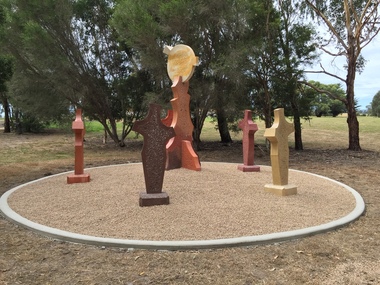 Federation University Art Collection
Sculpture, 'Mungo Moon' by Don Barrett, 2015
'Mungo Moon' by Don Barrett is the first sculpture erected on the Churchill Art and Culture Pathway. It was officially unveiled by Professor David Battersby on 15 April 2015 From Churchill & District News 16 October 2014 The Churchill Art and Culture Walking Pathway will have its official public opening on Saturday October 18, with a walk finishing at Federation University Australia’s Switchback Gallery at the Federation University Gippsland Campus. ... An important link on the newly developed pathway was recently completed with a path south of the FedUni Student West Residences. The path now allows walkers to turn off the Eel Hole Creek path before reaching Glendonald Estate and to follow a picturesque, tree lined walkway to join up with the footpath on the Eastern side of Northways Road. From there the footpath joins into Federation University’s network of walking paths that proceeds past the Switchback Art Gallery, down through the pine plantation and along Lake Kretlow and the Churchill Golf Course. Project Manager Mike Answerth, said the opening of the West Residences section of the path means there is now only one short link to complete. “We’re now very close to realising the project’s objective to join up all these walking paths to provide a continuous pathway that encompasses town, campus and parkland. The next stage of the project will be the completion of Latrobe City’s East West Link and the enhancement of the walking path with artistic and cultural features.” said Mr. Answerth. Head of Federation University Australia Gippsland Campus, Dr Harry Ballis, said the project had been made possible through the contributions of the five former Gippsland Education Precinct (GEP) partners. “The Art and Culture Pathway represents another important step in joining the Churchill township and the university campus as a physical and social entity,” Dr Ballis said. “This was an initiative of the GEP and it is pleasing to see it coming to fruition.” The path now reaches as far as the golf driving range but plans are already under way to connect with the Mathison Park board walk and pathway, which surrounds Lake Hyland in Churchill. When the loop is completed, residents and visitors will have an approximately 5km circular walking path which links up the Churchill town centre, Federation University Australia and Mathison Park. There are already art features along this route, including primary schools’ Bug Blitz totems near the Kurnai College school crossing, native vegetation and history panels near the Hare Homestead in Mathison Park, and outdoor sculptures in the pine trees near the Federation University Switchback Gallery. contemporaryA large sculpture in five pieces set in an external location. It is part of the Churchill Art and Culture Walking Pathway. Don Barrett’s work is mainly in concrete with added coloured oxides to portray the feeling of the Australian landscape. Barrett focuses on concepts of Australia’s short history and indigenous history. churchill art and culture pathway, barrett, don barrett, gippsland campus, federation university, churchill, sculpture -
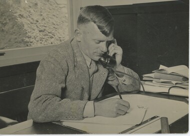 Falls Creek Historical Society
Photograph - Ray, Joan and John Meyer
MEYER COLLECTION - FALLS CREEK PHOTOS In 1947 a determined group of like-minded State Electricity Commission (SEC) staff including Ray Meyer, the chief surveyor of the Kiewa Hydro-Electric Scheme, had a common interest that revolved around the skiing potential of the snow-covered high plains which included what is now the resort of Falls Creek. The six SEC employees, Toni St Elmo, Ray Meyer, Jack Minogue, Lloyd Dunn, Adrian Ruffenacht and Dave Gibson (together with their families) banded together to secretly build a 'hut' that was the first ski lodge at Falls Creek. Using a road built in 1930s to gain access to Falls Creek, their hut project was carried out in secret as efforts by other skiers were blocked by H.H.C. Williams – the engineer in charge of the Hydro Scheme. In 1946 Ray Meyer made a trip to the Lands Office in Melbourne. He came away with a 99-year lease on three acres that was ideally suited for a hut designed by Lloyd Dunn. Adrian Ruffenacht (Design Engineer for the KHS) had suggested where the group should build because of easy access to a spring for water. Much of the building material required was scavenged from derelict huts on the high plains. Due to the need for secrecy, the determined group worked on the hut in the evenings and weekends to avoid detection. During the building period the group had met at Echidna Rock (now known as Eagle Rock) where Skippy St Elmo announced, "This is my favourite ‘Skyline’.” And so the first lodge in the area at Falls Creek Ski Resort came into existence. With the development of the International Poma in the 1970s, the Skyline Lodge, which was sited between the ski-lift’s pole one and pole two, was demolished. However, the legacy of Ray Meyer, Toni St Elmo, Jack Minogue, Lloyd Dunn, Adrian Ruffenacht and Dave Gibson and Skyline lives on in the vibrant atmosphere of Falls Creek Resort. The MEYER COLLECTION documents developments on the Kiewa Hydro Scheme and their life at Falls Creek from the mid 1930s to 1960s.This image is significant because it depicts aspects of the life of a pioneering family of Falls Creek and the founders of "Skyline", the first lodge at Falls Creek.A set of four photos of the Meyer Family. 1. Ray Meyer at the SEC office at Bogong 1946 2. Joan and John Meyer at No r. Raceline, Kiewa c1950 3. Ray and John Meyer at West Kiewa, No.5 c1950 4. John Meyer at West Kiewa, No.5 c1950falls creek, victorian snowfields, dinner plain, joan martin, joan meyer -
 Falls Creek Historical Society
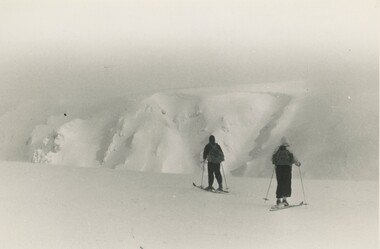
Photograph - Bogong Trip 1951- Cairn Gully and West Peak
MEYER COLLECTION - FALLS CREEK PHOTOS In 1947 a determined group of like-minded State Electricity Commission (SEC) staff including Ray Meyer, the chief surveyor of the Kiewa Hydro-Electric Scheme, had a common interest that revolved around the skiing potential of the snow-covered high plains which included what is now the resort of Falls Creek. The six SEC employees, Toni St Elmo, Ray Meyer, Jack Minogue, Lloyd Dunn, Adrian Ruffenacht and Dave Gibson (together with their families) banded together to secretly build a 'hut' that was the first ski lodge at Falls Creek. Using a road built in 1930s to gain access to Falls Creek, their hut project was carried out in secret as efforts by other skiers were blocked by H.H.C. Williams – the engineer in charge of the Hydro Scheme. In 1946 Ray Meyer made a trip to the Lands Office in Melbourne. He came away with a 99-year lease on three acres that was ideally suited for a hut designed by Lloyd Dunn. Adrian Ruffenacht (Design Engineer for the KHS) had suggested where the group should build because of easy access to a spring for water. Much of the building material required was scavenged from derelict huts on the high plains. Due to the need for secrecy, the determined group worked on the hut in the evenings and weekends to avoid detection. During the building period the group had met at Echidna Rock (now known as Eagle Rock) where Skippy St Elmo announced, "This is my favourite ‘Skyline’.” And so the first lodge in the area at Falls Creek Ski Resort came into existence. With the development of the International Poma in the 1970s, the Skyline Lodge, which was sited between the ski-lift’s pole one and pole two, was demolished. However, the legacy of Ray Meyer, Toni St Elmo, Jack Minogue, Lloyd Dunn, Adrian Ruffenacht and Dave Gibson and Skyline lives on in the vibrant atmosphere of Falls Creek Resort. The MEYER COLLECTION documents developments on the Kiewa Hydro Scheme and their life at Falls Creek from the mid 1930s to 1960s.This image is significant because it depicts aspects of the life of a pioneering family of Falls Creek and the founders of "Skyline", the first lodge at Falls Creek.Two black and white images taken on a trip to Mt. Bogong in 1951. 1. West Peak from Eskdale Saddle - Ray Meyer and Wal Johnson 2. Cairn Gully and West Peakfalls creek, bogong high plains, staircase spur memorial, ray meyer, wal johnson -
 Falls Creek Historical Society
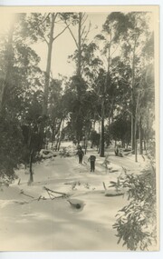
Photograph - Bogong Trip 1951- Near top of Timms Spur
... lodge at Falls Creek. Falls Creek Bogong High Plains West Peak ...MEYER COLLECTION - FALLS CREEK PHOTOS In 1947 a determined group of like-minded State Electricity Commission (SEC) staff including Ray Meyer, the chief surveyor of the Kiewa Hydro-Electric Scheme, had a common interest that revolved around the skiing potential of the snow-covered high plains which included what is now the resort of Falls Creek. The six SEC employees, Toni St Elmo, Ray Meyer, Jack Minogue, Lloyd Dunn, Adrian Ruffenacht and Dave Gibson (together with their families) banded together to secretly build a 'hut' that was the first ski lodge at Falls Creek. Using a road built in 1930s to gain access to Falls Creek, their hut project was carried out in secret as efforts by other skiers were blocked by H.H.C. Williams – the engineer in charge of the Hydro Scheme. In 1946 Ray Meyer made a trip to the Lands Office in Melbourne. He came away with a 99-year lease on three acres that was ideally suited for a hut designed by Lloyd Dunn. Adrian Ruffenacht (Design Engineer for the KHS) had suggested where the group should build because of easy access to a spring for water. Much of the building material required was scavenged from derelict huts on the high plains. Due to the need for secrecy, the determined group worked on the hut in the evenings and weekends to avoid detection. During the building period the group had met at Echidna Rock (now known as Eagle Rock) where Skippy St Elmo announced, "This is my favourite ‘Skyline’.” And so the first lodge in the area at Falls Creek Ski Resort came into existence. With the development of the International Poma in the 1970s, the Skyline Lodge, which was sited between the ski-lift’s pole one and pole two, was demolished. However, the legacy of Ray Meyer, Toni St Elmo, Jack Minogue, Lloyd Dunn, Adrian Ruffenacht and Dave Gibson and Skyline lives on in the vibrant atmosphere of Falls Creek Resort. The MEYER COLLECTION documents developments on the Kiewa Hydro Scheme and their life at Falls Creek from the mid 1930s to 1960s.This image is significant because it depicts aspects of the life of a pioneering family of Falls Creek and the founders of "Skyline", the first lodge at Falls Creek.Two black and white images taken at timms Spur on a trip to Mt. Bogong in 1951falls creek, bogong high plains, west peak, timms spur -
 Falls Creek Historical Society
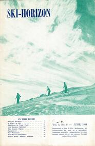
Journal - Ski-Horizon Vol 5 No 9
Ski-Horizon is the official journal of the Federation of Victorian Ski Clubs which began publication in 1949. The were 26 original member clubs which included Albury Ski Club, Bogong Ski Club, Myrtleford Ski Club, Tallangatta and District Ski Club and Wangaratta Ski Club. Two pioneers of Falls Creek, Tom Mitchell, M.L.A., and Martin Romuld were Vice-Presidents of the Federation.This Journal is significant because it documents the early development of skiing in Victoria.The journal features stories and events chronicling developments in Victoria and internationally. Items related to the Falls Creek Area in this issue include:- Page 3 - Myrtleford Ski Club has acquired a skiliner. It has seating for 20 passengers. Other clubs which own their own buses include Y.H.A,, Albury and Wangaratta. Page 7 - There seems to be a lack of interest in skiing anywhere at Falls Creek but the populated part of the Frying Pan Spur. There are other wonderful slopes on the west face of the Frying Pan, McKay, Ruined Castle and much further away at Spion Kopje and Timms. Bob Hymans and Toni St. Elmo are prepared to guide tour parties. Pages 14, 15 & 17 - A detailed article relating events of the opening weekend of the 1954 winter including activities at Falls Creek and Bob Hymans extensionsbob hymans, toni st. elmo, myrtleford ski club -
Friends of Ballarat Botanical Gardens History Group
Work on paper - Two Talks by Peter Butters, Yuille's Swamp and Our Botanical Gardens
Both articles give valuable brief histories of Lake Wendouree and Ballarat Botanical Gardens.These 2 articles explain how Lake Wendouree and the Ballarat Botanical Gardens came to be highly regarded for leisure time activities, for the study of flora and fauna and the parks and gardens.The 1st article, Yuille's Swamp is 31/2 pages of print with Peter Butters name added on p.4. The 2nd article, Our Botanical Gardens, is also 31/2 pages of print with Peter Butters name added on p.4.With the 1st article "Roy and then Peter Butters Talk, Guiding Group, 24/9/97" is written in blue biro, top righthand corner. Nothing is written in longhand on the 2nd article.john garner, doctor john garner, ballarat botanical gardens, friends of ballarat botanical gardens, yuille's swamp, lake wendouree, black swamp, tourism, eugene von guerard, gnarr creek, ballarat water supply, gong reservoir, view point, trams, fry's mill, .mining, english birds, acclimatization society, fish, carp, cormorants, reeds in lake wendouree, acquatic sports, steam boats, george longley, marble statues, trees, fernery, john garner collection, gardens, ballarat -
 Wonga Park Community Cottage History Group
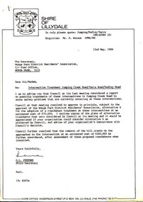
Work on paper (Item) - Letter, Wonga Park 1984 Letter from Shire of Lillydale to Wonga Park & District Residents' Association with four alternative intersection treatments
The Wonga Park and District Residents' Association requested the Shire of Lillydale consider removing the crests on Jumping Creek Road Wonga Park east and west of the intersection with Yarra and Dudley Roads to improve visibility at the intersection. The Shire of Lillydale thought that this would simply increase the speed of traffic through the intersection and suggested a roundabout be built and came up with four alternative treatments. When they discovered that a roundabout would require water mains to be lowered and the M&MBW would not give a quote on the cost (which would be substantial) they opted for traffic islands instead. -
 Melton City Libraries
Map, Streets of Melton, 1963
MELTON’S STREETS Heritage Week 2014 What’s in a Name? Alphabetical List Aboriginal place names, Early Family Names and landowners, Agricultural, Shop and Commercial premises, Places and Events Melton & District Historical Society Street Naming Project 1972 – c 1998 Suburb Name – KURUNJANG - Kirkton, 1972, Brookfield, West, 1988 Melton and Town Centre - A joint collaboration with the Shire of Melton and Subdivision Developers ARNOLD Court – Family house - Arnolds Creek ALKEMADE Drive Family – Lime kilns Coimadia ALEXANDRA Street 1902 – Corination of King Edward VII and Queen Alexandra AVIATOR Place Event, location of plane crash – Jimmy Melrose 1936 Adina ?Annibee - Anniba? Agricultural Avon court .. .. BAKERY Square - Location of Jongebloed shop, bakehouse and stables BALUK Place Aboriginal BARLEYCORN Place Agricultural BILLING Place Name of Jimmy Melrose Uncle Noel Pemberton Billing BLACKWOOD Drive - Alexander Blackwood 1860c Registrar BARRIES Road C. E. Barrie “Darlingsford” farmer 1911, chaff mill owner BROOKLYN Road Staughton family residence. 1875 – Dismantled c 193? CAHILL Drive Family - Glenville Dairy CAMERON Court Family Canopus Place ? CANALLAN Drive Early Surveyor CAMPBELL Court Aviation – Melrose passenger 6th July 1936 CARBERRY Drive Michael, early landowner family CAREW Court Edward and Michael. Royal Hotel. Vera (Carew) Forran Singer - Opera CASEY Court Family CASHIN Court Family CHEVIOT Court Agriculture, breed of sheep CHESNEY Road was re named ( Minns Road being duplicated c 1973) CHRISTINA Crescent Christina McPherson, daughter of James and Mary Mary McPherson. Died 1955 aged 85 years COLLYER Close a deleted street (parallel to Yuille) re-used CORRIEDALE Road Breed of sheep CORR Court Teacher at first school, landowner CROXTON Court Name of the Hornbuckle and Knox family home DALEY Court - William Daley and family 1865 Bootmaker High Street DARLINGSFORD Boulevard - Name of early homestead Thomas B Darling 1853 DJERRIWARRH Court - Parish County of Bourke - very early map. DODEMAIDE Place Early land owners - Melton Football Team had 6 brothers playing c 1924 DONALD Court McPherson family 6 generations in Melton in 1936 DOUGAL Court DUNCAN Court .. .. DUNVEGAN Circuit Home of the McPherson family, castle Isle of Skye Name of bluestone house Smith Street (now at Willows) EMIL Court Jongebloed family EXELL Avenue Farming family Melton Sth- Closer Settlement 1907 EXFORD Road Exe former name of the Werribee river FARMER Court Name of early postmistress FERRIS Road John Ferris Farmer HANNAH Close First name of Hannah Watts – midwife HAYBALE Place Agricultural HELDER Court Early surveyor J Helder Wedge map HEWSON Street Winston Hewson Shire Engineer – check title c 1960 HENRY Street Township map c 1860 HESTON Street Heston Phoenix – C.J. Melrose plane HILDEGARDE Court Jimmy Melrose’s mothers name HOMESTEAD Close HORNBUCKLE Cres Farmers. Three members of family - Shire Presidents HURLEY Street Farmers IAIN Court Descendent of James and Mary McPherson JAMES MELROSE Drive Name appears on 2013 Melton information map JANG Place KURUN – jang KIRKTON Drive Name of the McPherson family home Toolern Vale Road KIRWIN Street Michael early landowners (deleted for freeway construction) KILPATRICKS Road Deleted when Barries Road was extended across Station Rd KOROROIT Court Early map, Parish of Kororoit. Creek name KNOX Circuit Family – Hornbuckle “Croxton Park” KURRUNJANG Drive Aboriginal name for people of the red earth – Suburb name Lara Place ? LLOYD Court Garage owners High Street. Laura lived to 100 years D 1955 LUBY Court John Luby – Crown Grant Land Title LITTLE Court MANNING Avenue Richard, hotel owner 1891 MARGARET Drive McPherson family McDONALD Street Melton South family name McKENZIE Street Township c1860 MORROW Street Early name MOWBRAY Crescent Name of English Melton, popularly believed origin of Melton MYERS Court Early setters c 1866 Crown Grant Land Title NIMMO Street Early name NIXON Street Name submitted by Mary nee Nixon Collins c1985 OLDERSHAW Road Early builder PALMERSTON Street Early township map c 1860 PEART Court Early name PENNYROYAL Avenue Plant growing by the creek. Early name used for the Toolern Toolam Creek PINKERTON Street Family name and early street map PINNACLE Crescent Agricultural - type of wheat PHOENIX Circuit C.J. Melrose Phoenix Heston Plane 2013 map PRATT Family PRIOR Court PYKE Place Brothers – early settlement 1838 RADFORD Court Land owners and business operators. Former Royal Hotel Grocer High Street demolished 1970 RAGLAN Court Hotel 19th century Lord Raglan RALEIGHS Road Oliver Reierson family (Norweigen) Shopkeeper – Dressmakers RIDDELL Drive (misspelt Riddle) Resident and land owner RODERICK Road McPherson family – a re occurring name ROLLAND Court Jones family ROSS Court Daniel. Landowner. Agnes Ross music teacher RUSSELL Court Robert. Early land surveyor of Melton 1853 RYAN Court Family early landowner. Member of the 1862 Road Board SHEBLER Place Augustus early Melton resident – Golden Fleece Hotel SHEEPFOLD Court Farming SHERWIN Court Sherwin Street earliest Township map– became Golf course SMITH Street Early township map. STRATHULLOH Circuit Strathtulloh Homestead. STAUGHTON Street Family – LARGE land owners Strachan ? SWANEY Court Marie Swaney earlier resident of Strathtulloh. SUTHERLAND Family name TOOLERN Street TOOLAM – TOOLERN Creek TULLIDGE St Road marked on 1861 map UNITT Street Early Township c 1860 WALLACE Square Cr Jack Wallace 5 terms as President 46 years unopposed WATTS Court Hannah Watts – midwife, cottage hospital WALSINGHAM Name of house of Minns family. From Walsingham Norfolk England WESTLEY Place Name of Jimmy Melrose Percival Gull Plane WESTLAKE Drive Early resident WHICKHAM Street Family Name Melton South WILSON Road Albert, Melton South YUILLE Street William Cross, early landowner, Rockbank run Zoomed in section of Melton Streets including Church and High Streetlandscapes of significance -
 Melton City Libraries
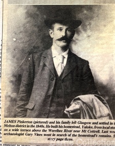
Newspaper, James Pinkerton, 1991
"James Pinkerton, described by fellow settler Isaac Batey as ‘a fine old Scotish [sic] gentleman’, and his wife Margaret established ‘Chamois Ponds’ on Kororoit Creek in the Keilor district in 1840.44 After a fire in 1848, the Pinkerton family moved further west to a holding called Yaloke, on the Werribee River in the Melton district.45 Today, the Surbiton Park water treatment plant operates on part of the Yaloke run. The Pinkerton family is remembered in Melton in part due to the historic graves of the original settler, Margaret Pinkerton, and four of her grandchildren, which were marked by a memorial cairn in 1931. Changes to sewage flood zoning in the area in the 1990s necessitated that these burials be relocated. Members of the Melton & District Historical Society oversaw a project to relocate the Pinkerton graves and cairn 200 metres from their original site to their current resting place at Mount Cottrell. This relocation ceremony took place on 8 November 1992, with the participation of local school students and with Pinkerton descendants playing a central role. This occasion also marked the opening of the Pinkerton Forest Project, which saw 50 hectares of degraded woodland in Surbiton Park protected for regeneration".Photograph of Jame Pinkerton featured in the the Telegraphlocal identities, pioneer families -
Tarnagulla History Archive
Handwritten note, 9 September, 1872
A large lot of papers, including this note and many telegrams, were apparently found in the ceiling cavity of the Sandy Creek/Tarnagulla Post and Telegraph Office in the later 20th Century, during building works. Donald Clark Collection. A handwritten note, probably a draft for a telegram sent from Tarnagulla Telegraph/Post Office. From ______ ________ to Mr St. Dods, care 42 Flinders Lane West Melbourne. Message reads 'Acceptance returned. pay into Union Bank immediately and wire to'. -
Tarnagulla History Archive
Folder - School Records, 1990s
Binder containing historical information about schools in Tarnagulla, Llanelly, Murphy's Creek, Jones Creek/Waanyarra, Laanecoorie, Arnold and Arnold West. Contains several lists of names of children who attended the schools. Compiled by Donald Clark. Good picture of Waanyarra School.