Showing 22200 items
matching parks
-
 Greensborough Historical Society
Newsletter, Greenhills and North Greensborough Progress Association, Community News: official journal of the Greenhills and North Greensborough Progress Association. 20th July 1970. Edition No. 6/70, 20/07/1970
This edition includes a report on the Progress Association's July1970 meeting, Councillors' report, Roads, nature or "nature strips", Protecting and improving the Plenty River, Toxic insecticides - the total dangers, New park complex to be Bundoora Fields, School and Kinder news, Scout and Guide news, Letter to editor.Newsletter, 16 p., illus. greenhills and north greensborough progress association, greenhills -
 Mission to Seafarers Victoria
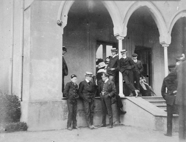
Photograph, Seamen standing in front of the house - Findon, Kew
This house is probably "Findon", Studley Park in Kew, belonging to Mrs Aubrey Bowen, widow of eye surgeon Thomas Aubrey Bowen (1837-1893). She welcomed large groups of seamen (up to 125) for Boxing Day at least on three consecutive years in 1906, 1907, 1908. Small monochrome photograph (faded) depicting outdoor gathering of seamen in front of a building with arches at one of the summer venues.findon, mrs aubrey bowen, thomas aubrey bowen, boxing day, kew, studley park -
 Eltham District Historical Society Inc
Photograph, Looking north across the Fitzsimons Lane Bridge over Yarra River between Eltham and Templestowe, c.1985, 1985c
Turnoff to Candlebark Park on right. Originally Fitzsimons Lane was the name of the road on the Templestowe side of the Yarra River; on the Eltham side it was known as the Eltham-Templestowe Road. When the new bridge was built the divided road was not continued in the Shire of Eltham as it would have required a significant widening of the cutting.Colour photographinfrastructure, shire of eltham infrastructure, bridge, fitzsimons lane bridge, yarra river, candlebark park, red nose day -
 Stawell Historical Society Inc
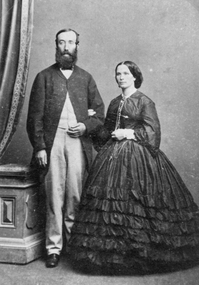
Photograph, Mr David Scallan & his Wife -- Studio Portrait
Portrait of David Scallan & his Wife. David Scallan was a mining broker. David was also the first Shire President 1864 - 65. In 1864 he was a member of the Roads Board. Also, the first Committee of Management of Central Park. One of the main Stawell inner streets is Scallan St.Photograph of a woman and gentleman standing in a studio setting. Womans frock has a frilled skirt with long sleeves. Gentleman had light coloured trousers with a long dark coat buttoned at the neck. c 1865 - 70'sstawell -
 Rutherglen Historical Society
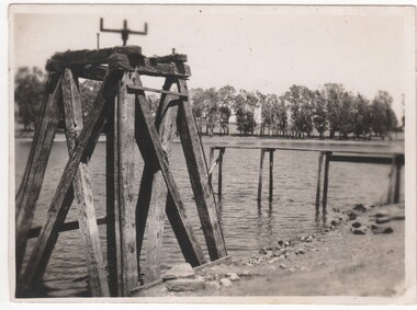
Photograph - Image, 1962 (Approximate)
Lake King in Rutherglen Park is a man made lake and was the town's original reservoir for household water supplies. After the Water Tower was built, Lake King was used by the local children as a swimming pool. Since the Swimming Pool was built, Lake King has reverted to a beauty spot.Small black and white snapshot of Lake King and Pier and equipment used for Reservoir purposes - UnmountedOn back: "Lake King pre 1962 from Nokie Morrison"lake king, reservoir -
 Robin Boyd Foundation
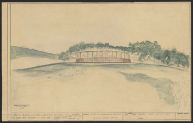
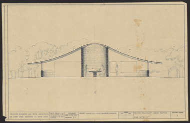
Drawing - External perspective, Tower Hill Lake Reserve Museum, Jun-61
In 1961 Robin Boyd designed the Tower Hill Reserve Visitors Centre to fit naturally within the surrounding terrain. The building’s shape reflects a volcanic cone. The windows allow a 360-degree view of the park. The Centre opened just after Robin Boyd’s death in October 1971. Project: Tower Hill Lake Reserve Museum drawn by Robin Boyd of Grounds, Romberg & Boyd. Drawing no 2. General view and external perspective. Watercolour on dyeline. tower hill, robin boyd, ohm2022, ohm2022_15 -
 Robin Boyd Foundation
Drawing - External perspective, Tower Hill Lake Reserve Museum, Jun-61
In 1961 Robin Boyd designed the Tower Hill Reserve Visitors Centre to fit naturally within the surrounding terrain. The building’s shape reflects a volcanic cone. The windows allow a 360-degree view of the park. The Centre opened just after Robin Boyd’s death in October 1971.Project: Tower Hill Lake Reserve Museum drawn by Robin Boyd of Grounds, Romberg & Boyd. Drawing no 3. Watercolour on dyelinetower hill, robin boyd, ohm2022, ohm2022_15 -
 Ballarat Tramway Museum
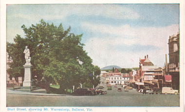
Postcard, Valentine & Sons Publishing Co, "Sturt Street showing Mt Warrenheip, Ballarat, Vic.", c1950
Coloured Postcard looking east along Sturt St south side from Lydiard St, with Mt Warrenheip in the view. A tram is parked in the loop. The Robbie Burns statue, Ballarat Gas Co and the Buckshead Hotel are in the view. Based on the cars, c1950. Published by Valentine Publishing Co. Demonstrates a coloured postcard produced by Valentine.Postcard - coloured - divided back, not used.sturt street, ballarat, mt warrenehip -
![Original fishermen's waiting shed from the Queenscliff Pier containing paintings of ships most of which had passed through the heads, with a few prominent exceptions whimsically added [eg Titanic]. paintings attributed to Henry Zanoni, a prominent local fisherman. The shed and paintings are listed by the Victorian Heritage database.](/media/collectors/4f729f7e97f83e03086018d1/items/4f72bc7a97f83e03086063a8/item-media/506914242162ef09fc8f08fe/item-fit-380x285.jpg) Queenscliffe Maritime Museum
Queenscliffe Maritime MuseumFunctional object - Fisherman's Waiting Shed, Henry Zanoni, 1856
Originally located on the Queenscliff Pier from 1856. It was known as the waiting shed for registered fishermen. It was moved from Queenscliff pier to near slipway in 1960, then to Princess Park in the 1970s and to the museum in late 1980. Henry Zanoni, a fisherman was responsible for painting the many pictures of ships on the inside walls.Waiting Shed for Registered Fishermen Weatherboard - Timber Cream Weatherboards and Brown Trimfishermen waiting shed, queenscliff -
 Ballarat Tramway Museum
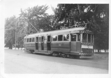
Photograph - Tram 40 Gardens Loop, 1/1966
Photograph - Black and white of Ballarat tram No. 40 parked at Gardens Loop in Wendouree Parade. In the background are the large trees that were a feature of this location. Not known who took the photo during Jan. 1966. Note the two numbers on the front of the tram, as result of the installation of the dash canopy lighting.Yields information about the appearance of tram No. 40 during Jan 1966 and Gardens Loop.Black and white photograph on Ilford paper.In ink on rear "Gardens 1/66"tramways, tram 40, wendouree parade, gardens loop, tramcars -
 Wonga Park Community Cottage History Group
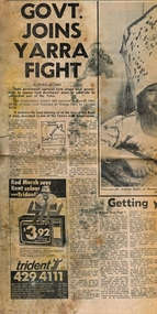
Newspaper (Item) - Cutting, Wonga Park: Herald newspaper cutting 16/9/1972 Govt Joins Yarra Fight
State Government agencies have joined local government to oppose lan developers' plans to subdivide an untouched pat of the Yarra. The subdivision involves 565 hectares (Yarra Brae and Stane Brae) and more than 16 kms of bush river frontage at Wonga Park in Lillydale Shire -
 Melton City Libraries
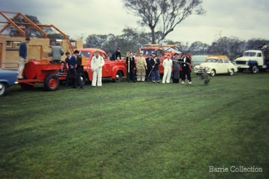
Photograph, Shire centenary, 1962
Bon Barrie, Graeme Cooper, N. Gillespie, Peter Barrie, Ken Robinson, Ray Allen, Tom Barrie, John Roaers and Graeme Gilliland, members of the Mt Cottrell Fire Brigades Group In the background of the photo is the pavilion during construction, Melton Recreation Park on Reserve Road.Melton South Trailer tank, pump and Syd Coopers Car at the Shire centenarycouncil, local significant events, emergency services -
 Wodonga & District Historical Society Inc
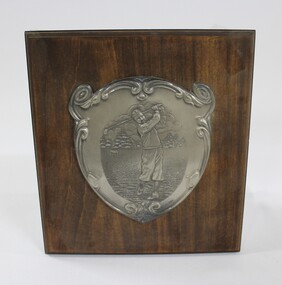
Plaque - Wodonga Golf Club Plaque
A commemorative plaque from the old Wodonga Golf House, built in 1946. The club house and the golf course were extended in 1956 to the area of Belvoir Park. It was demolished in 1987 to make room for the new Hume Highway. This plaque was salvaged from the club house building before demolition. This item has a strong link to the local and sporting history of Wodonga.A wooden plaque with engraved metal plate depicting a male golfer attached. gold, sport, leisure, entertainment, wodonga, wodonga golf club -
 Melbourne Tram Museum
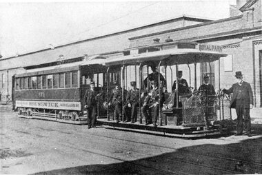
Photograph - Black and White Cable tram Brunswick Depot Sydney Road
Photograph shows a cable tram or cable train, consisting of a grip car or dummy along with a bogie trailer (No. 473) outside the Brunswick cable tram or car house with seven gripmen or conductors and possibly a manager around the grip car. The grip car has the destination of Royal Park. Yields information about the Brunswick cable line and the Brunswick Depot. Black and White Cable tram Brunswick Depot Sydney Road reproduced from a Newspaper.sydney road, trams, tramways, cable trams, brunswick depot, crews, grip men, conductors, tram 473 -
 Melbourne Tram Museum
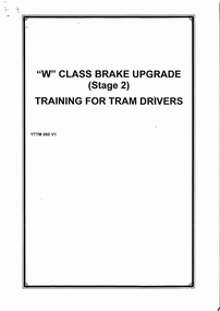
Document, Yarra Trams, "W class brake upgrade (Stage 2), training for drivers", 6/2002
Document - for the training of tram drivers of W class trams with modified braking systems. Has a table of contents, explaining the changes, vigilance control, emergency, and park brakes. This system followed several rear-on collisions due to indifferent braking systems. Produced by Yarra Trams June 2002.Yields information about the modified braking systems on W class trams.Document - 16 A4 pages was stapled in top left hand corner.trams, tramways, w class trams, brakes, driver training -
 Warrnambool and District Historical Society Inc.
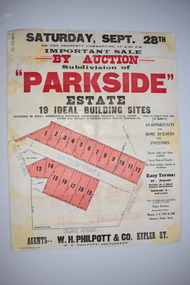
Work on paper - Original Document, H J Paynter, Advertisement "Parkside"Estate subdivision, Circa 1935
This sheet denotes an auction of land which is situated close to Albert Park on the northern part of Warrnambool. The area is complete now with homes which are a mixture of brick and concrete faced houses. The agent W H Philpott was operating in Warrnambool from the 1930's though to 1950'sThis item has local interest and significance as it records the sale of Warrnambool land.Large white paper sheet with black and red text. The auction details are at the top and down the righthand side with a map of the available blocks are coloured red and outlined in black.Parkside estate, W H Philpott & Co Kepler St , R V Philpott auctioneer,Solicitors J S Tait & son. Cramer Street, Nelson Street McConnell Street.warrnambool, mcconnell street warrnambool -
 Warrnambool and District Historical Society Inc.
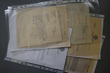
Administrative record (collection) - Documents relating to house in Warrnambool, 1951
Collection maintained by daughter of original owner.Historical reasonsCollection of items in folder in chronological orderCorrespondence from Government and legal sourceswarrnambool housing post world war twowarrnambool housing post world war two -
 Eltham District Historical Society Inc
Photograph, Entrance to Shire of Eltham Memorial Park, Garden Hill, Eltham-Yarra Glen Road, Kangaroo Ground, c.1923
View to south-east from Shire of Eltham Soldiers' Memorial Park showing the carriageway from the road to top of Memorial Park. Accompanying notes state that the entry gate was put in place in May 1921. Eltham and Whittlesea Shire Advertiser and Diamond Creek Valley Advocate Fri 21 May 1920 p 2 reported: Kangaroo Ground Memorial Park "It was decided to arrange for a working bee on Saturday, 29th inst., for the purpose of forming and gravelling the track leading to the Park, and of carrying out other necessary works." A history summary of the Shire of Eltham Soldiers’ Memorial Park • The summit at Garden Hill was a popular tourist lookout and picnic spot from the 1880s. Virtually the entire Shire of Eltham and beyond could be viewed from this location. • A local farmer, Mr Walter A. D. Wippell is credited as being the first to propose the idea of a war memorial park and offered £50 towards the purchase of the land. • The earliest public reference to this project is to be found in the local Advertiser newspaper edition of August 9th, 1918. A report of the August Council meeting records the Eltham Shire President, Cr. Robert White, saying: "some time back it was proposed that the Council obtain and place on an Honour Board in the Council Chamber [at Kangaroo Ground] containing names of the lads who had enlisted. Just recently however, it had been suggested that a more fitting memorial would be the obtaining of a piece of land on the summit of Garden Hill, Kangaroo Ground, and the formation of a memorial park in which a monument could be erected to represent the whole of Shire. If a couple of acres could be obtained a gentleman had promised to donate 50 pounds, and another one would fence it, and other contributions, he was sure, could be obtained." • Councillors were favourable of the proposal and the President, Shire Secretary and Shire Engineer were deputised to wait on Messrs Mess Bros. (the owners of the Garden Hill farm) and ascertain if they would gratuitously give the land. The Mess Bros. land adjoined the farm/stud of Mrs Fanny White (Cr Robert White’s mother), daughter of Andrew Harkness who established their property on Garden Hill around 1846. • Access to the land came in February 1919 when several Councillors and the Shire Engineer surveyed the actual two acres of '5 chains along the road and 4 chains deep'. The Engineer volunteered his services free to do this task. The Mess brothers however demanded £100 per acre but eventually agreed to take £50 per acre. • Entry from the Kangaroo Ground-Yarra Glen road was seen to be a problem and Mrs. White, who owned the land beside the park, was asked to donated a triangle of her property to allow this access. • By September 1919 returned soldiers were employed by the Shire and volunteers were called to clear the hilltop by ploughing up the rocks and clearing the area, the fencing was put into place and in May 1921 the Council erected three gates, within an archway, at the entrance to the drive and pathway to the summit. • Public subscriptions were sought through the Advertiser newspaper to beautify the site. The views of the Curator of the Melbourne Botanical Gardens were sought as to the ‘class of ornamental trees most suitable for planting in the Park area”. • The Memorial Park or Shire of Eltham Soldiers’ Memorial Park was officially opened by Mr. W.H. Everard, M.L.A., 3 September 1921. • In 1922 plans were made to place a War Memorial in the Park. Funds were donated by the Council of £250 and a challenge to the community, to match this money with contributions was met. • On Anzac Day 1923, 1,000 people gathered on the summit in the park for a memorial service. A much smaller group of about 50 people gathered around a newly constructed cairn and flagstaff in the afternoon of Anzac Day 1924 amidst rain and a squally southerly wind, the morning service being cancelled. • A meeting for those interested in establishing a War Memorial monument within the park was held in January 1924 and the Eltham Shire War Memorial League was formed and a design competition decided upon. • The Shire of Eltham War Memorial tower was built in 1926 at a cost of £1,023 and 5 shillings with locally quarried stone donated by Dr Ethel and Professor William Osborne. It was formally known as the ‘Shire of Eltham War Memorial’ and was unveiled on 11 November 1926. The large bronze inscription above the entrance to the tower states: SHIRE OF ELTHAM WAR MEMORIAL THESE MEN DIED FOR THEIR COUNTRY 1914 IN REMEMBRANCE THIS TOWER WAS BUILT 1918 • The Caretaker’s hut was built in 1927 with left over from the tower construction. • A returned soldier was appointed to act as caretaker for the memorials. Tiny Carrol, a huge man, was the first caretaker and lived in the stone hut. There was a push to have alterations made at one stage to provide additional rooms for a married caretaker but was rejected. • A new Caretaker Cottage was built in 1951 at a cost £2,500. The cottage had been subjected to raids by thieves three times during construction until a guard from the Returned Servicemen’s League was posted until its opening. • The War Memorial tower was re-dedicated by Sir Dallas Brooks on 8 November 1951, unveiling new bronze plaques containing the names of those who fell during the Second World War. Sir Dallas also officiated the opening of the new Caretaker’s Cottage. • A toilet block was built in 1965. • A further dedication of the Shire of Eltham War Memorial tower took place 11 November 2001 to recognise the men who fell in subsequent campaigns up to and including Vietnam. • Four land titles are involved: o The purchase of the two acres from owners Ruth Gosling, Alexander Mess, James Johnson Mess and Joseph Mess is recorded in two actions, the first being the payment of £100 for the two acres, the second showing that the Shire of Eltham did not get a transfer of title until 14th January 1952. o The access land donated by Mrs. Fanny White is dated 26 February 1924. A further need to widen the entry came after the deepening of the road cutting and another land donation was given by Sir Herbert Gepp, title dated 15th May 1952. This would have been about the time he sold off the former White ‘Garden Hill’ property. o The land reserve to increase the area and possibly allow a circuit road to be put in place on the western side of the park was purchased by the Shire of Eltham, title dated 16th February 1973. Rare photograph of the entrance to the Shire's Memorial Park during early stages of development prior to the erection of the Shire of Eltham War MemorialSepia photograph printed with white border with slight crack lower left hand corner and three significant vertical cracks fanning from lower centre edge to upper edge Digitally enhanced version to minimise impact of crackseltham-yarra glen road, entrance gate, garden hill, kangaroo ground, shire of eltham memorial park, shire of eltham war memorial, kangaroo ground war memorial park -
 Warrnambool and District Historical Society Inc.
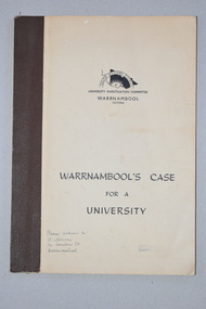
Booklet, Warrnambool's Case for a university, 1961
The information in this booklet was prepared by a University Investigation Committee formed in Warrnambool in 1961 to present the case for the establishment of a university in the Warrnambool area. The chairman of this committee was the Mayor of Warrnambool, Cr P. O’Sullivan and the secretary was W. L. George of Warrnambool. This submission was unsuccessful at the time but campaigning for a university continued. In 1961 Warrnambool Technical School in Timor Street was offering both secondary and tertiary courses in the technical and trades areas and in 1969 the tertiary section of this Technical School became the Warrnambool Institute of Advanced Education. The tertiary section was relocated in 1984 to Sherwood Park, a 94 hectare site on the Princes Highway five kilometres from Warrnambool’s C.B.D. In 1990 Deakin University established a regional campus at Sherwood Park after a merger with the Warrnambool Institute of Advanced Education. This booklet has some historical significance as it contains the information collated on the campaign in Warrnambool and the Western District for a university to be established in the Warrnambool area.This is a soft cover booklet of 48 pages. It has a beige-coloured cover with black printing. The booklet has been bound with brown tape. It has printed information, black and white photographs, a fold-out map, graphs and tables.deakin university, history of warrnambool -
 Eltham District Historical Society Inc
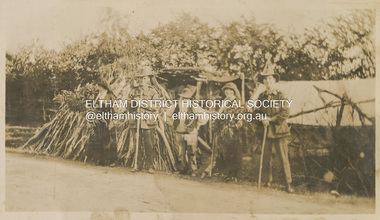
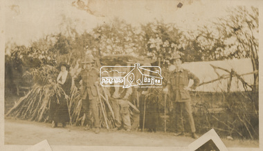
Photograph, "McGeachy, Curry, Byrne & Caffery with an old man who lives there at Eltham", 22 Oct 1919
This photo depicts an outing of VAD nurses Alice Broadhurst, McGeachy and Byrne and two patients of No. 16 AGH Macleod (Mont Park Military Hospital), Curry and Caffery to Eltham in spring 1919. Broadhurst's companions pose with an old timer from Eltham on the roadside verge with a large collection of sticks stacked vertically outside a cottage. This photo is part of the Alice Broadhurst collection held by Yarra Plenty Regional Library, a series of 12 photo albums compiled by Alice Broadhurst (1896-1981), initially while working as a Voluntary Aid Detachment nurse with the Australian Red Cross at the Mont Park Military Hospital (No. 16 AGH) and subsequently as a nurse at the Royal Melbourne and Royal Women’s hospitals alongside many pioneering doctors of their fields.Digital file"McGeachy, Curry, Byrne & Caffery with an old man who lives there at Eltham"eltham, alice elizabeth broadhurst, byrne, caffery, curry, mcgeachy, nursing staff, mont park, 16 agh, old timer, pioneer, cottage, wood pile -
 Eltham District Historical Society Inc
Photograph, "Same group with self instead of Byrne, Eltham", 22 Oct 1919
This photo depicts an outing of VAD nurses Alice Broadhurst, McGeachy and Byrne and two patients of No. 16 AGH Macleod (Mont Park Military Hospital), Curry and Caffery to Eltham in spring 1919. Broadhurst's companions pose with an old timer from Eltham on the roadside verge with a large collection of sticks stacked vertically outside a cottage. This photo is part of the Alice Broadhurst collection held by Yarra Plenty Regional Library, a series of 12 photo albums compiled by Alice Broadhurst (1896-1981), initially while working as a Voluntary Aid Detachment nurse with the Australian Red Cross at the Mont Park Military Hospital (No. 16 AGH) and subsequently as a nurse at the Royal Melbourne and Royal Women’s hospitals alongside many pioneering doctors of their fields.Digital file"Same group with self instead of Byrne, Eltham, Oct 22"eltham, alice elizabeth broadhurst, byrne, caffery, curry, mcgeachy, nursing staff, mont park, 16 agh, old timer, pioneer, cottage, wood pile -
 Eltham District Historical Society Inc
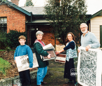
Photograph, Diamond Valley Leader, Eltham Local History Centre, former Police Residence, 728 Main Road, Eltham, 1998
Members of the Eltham District Historical Society transfer collection items from storage into their new home. Previously occupied by the Parks and Environment Department of Nillumbik Shire Council (L-R: Mark Gillham, Margaret Ball Vice President, Sue Law Immediate Past President, Harry Gilham President) Nillumbik Shire Council Commissioner Vin Heffernan (1996-97) worked with Harry Gilham to obtain use of the former Eltham Shire Parks and Gardens office at 728 Main Road for use by the Society. Harry as a younger man had played in the scrum for Heidelberg Football Club along with Vin's brother who was on the wing. Apparently Heffernan was able to access $30K to spend on the site to fix it up for occupation.Colour photo print 12.5 x 19 cmLeaser Newspaper Groupmargaret ball, mark gilham, police residence, sue law, 728 main road, activities, eltham, eltham district historical society, harry gilham, justice precinct, local history centre -
 Eltham District Historical Society Inc
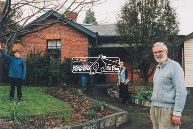
Photograph, Eltham Local History Centre, former Police Residence, 728 Main Road, Eltham, 1998
Members of the Eltham District Historical Society transfer collection items from storage into their new home. Previously occupied by the Parks and Environment Department of Nillumbik Shire Council (L-R: Mark Gillham, Margaret Ball Vice President, Sue Law Immediate Past President, Harry Gilham President) Nillumbik Shire Council Commissioner Vin Heffernan (1996-97) worked with Harry Gilham to obtain use of the former Eltham Shire Parks and Gardens office at 728 Main Road for use by the Society. Harry as a younger man had played in the scrum for Heidelberg Football Club along with Vin's brother who was on the wing. Apparently Heffernan was able to access $30K to spend on the site to fix it up for occupation.Colour photographeltham district historical society, harry gilham, margaret ball, mark gilham, sue law, local history centre, 728 main road, activities, eltham, justice precinct, police residence -
 Eltham District Historical Society Inc
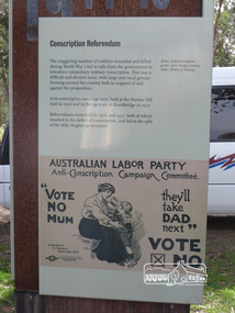
Photograph, Shire of Nillumbik World War One Memorials tour, 10 August 2016, 10 August 2016
As part of a program to acknowledge the Anzac Centenary Nillumbik Shire Council partnered with Yarra Plenty Regional Library to provide a bus tour with commentary of local sites of significance. These included Eltham township, the Shire of Eltham War Memorial at Kangaroo Ground, Christmas Hills, Hurstbridge memorial recreation park and finished at Eltham Library to view the Writing the War exhibtion at Eltham Library Community Gallery. In June 2014 Nillumbik Shire Council received Anzac centenary Local Grants Program funding to create new interpretative signage that acknowledged the history of the Hurstbridge Memorial Recreation Park as a memorial to all who served in the First World War. One of the tall panels includes a discussion of conscription in World War One. Born Digitalworld war 1, war memorials, shire of nillumbik, hurstbridge, interpretative signage, conscription -
 Melbourne Tram Museum
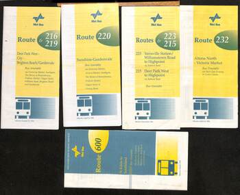
Ephemera - Timetable - Met Bus - set of 5, The Met, 1996/97
Set of 5 Met Bus timetables - all with a route map on the rear. 1 - Routes 216 and 219, Deer Park West - City - Brighton Beach/Gardenvale - dated 27/10/1996 2 - route 220 - Sunshine - Gardenvale - dated 14/4/1996 3 - Routes 223 and 215 - Yarraville Station to Highpoint and Deer Park West to Highpoint - dated Dec. 1996 4 - Route 232 - Altona North - Victoria Market via West Gate Freeway and Crown Casino - dated 14/4/1996 - this service effectively combined the two railway tram routes. 5 - Route 600 - St Kilda to Southland via Elwood, Brighton, Sandringham, Black Rock and Cheltenham - dated March 1997Yields information about some of the Met Bus services in 1996 and 1997.Set of five Met Bus timetables, DL size, printed in two colours.maps, bus services, route 216, route 219, route 220, route 223, route 215, route 232, route 600, met bus -
 Bendigo Historical Society Inc.
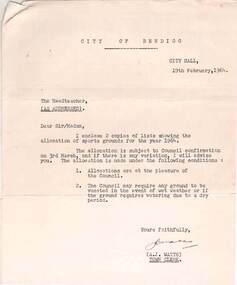
Document - NORMAN OLIVER COLLECTION: ALLOCATION OF SPORTS GROUNDS FOR SCHOOLS 19 FEBRUARY 1964
The Norman Oliver collection. Norman Oliver was three times Mayor of Bendigo - 1950-51, 1964-65, 1970-71. Three typed pages - a covering letter from City Hall dated 19th February 1964, to the Head teacher regarding the allocation of sports grounds for 1964, a weekly timetable for the use of each ground by a particular school, and a list of special allocations. The grounds allocated are : Queen Elizabeth Oval, Showgrounds, Kennington, Golden Square, Ewing Park, Wilkie Park, Centenary Oval, Garden Gully, Garden Gully (new Basketball courts), North Bendigo Recreation Reserve, Allingham St., Quarry Hill, White Hills, Long Gully, and Londonderry. Weeroona Oval and the Olympic Pool are included in the special allocations list for events such as annual sports days, inter-school sports and school swimming carnivals.bendigo, council, norman joseph oliver , councillor norman oliver. mayor of bendigo. school sports. bendigo sports grounds. -
Kew Historical Society Inc
Archive (Sub-series) - Subject File, JUDD Family, 1958
Various partiesReference, Research, InformationKHS OrderSubject file containing information important information by and about the Judd family, pioneers of Kew, and owners of Park Hill (now in Hillcrest Avenue) from 1853. The file contains a number of original files provenanced to the Judd family including a subdivision brochure of the Park Hill Estate (1916) that includes a map of the subdivision, an early photo of the ten-roomed house. Other primary sources include a seven page photocopy (& transcript) of notes on early Kew by Thomas Judd Jnr (1950). An undated letter accompanying the information refers to Miss Ina Balaam, the last descendant of the family to live in the house. The file also includes a photocopy of the obituary of Thomas Judd and a newspaper article/clipping from 1972, which includes a short history of the house and a photograph. Other items relating to Thomas Judd and James Bonwick are stored in archive boxes in the collection store.c w rick fairhall, parkhill - hillcrest avenue - kew (vic), thomas judd, pioneers - kew (vic)c w rick fairhall, parkhill - hillcrest avenue - kew (vic), thomas judd, pioneers - kew (vic) -
 Kew Historical Society Inc
Photograph, J F C Farquhar, Bird's Eye View Looking West, 1891
At the beginning of the 1890s, the Kew businessman and Town Councillor, Henry Kellett, commissioned J.F.C. Farquhar to photograph scenes of Kew. These scenes included panoramas as well as pastoral scenes. The resulting set of twelve photographs was assembled in an album, Kew Where We Live, from which customers could select images for purchase.The preamble to the album describes that the photographs used the ‘argentic bromide’ process, now more commonly known as the gelatine silver process. This form of dry plate photography allowed for the negatives to be kept for weeks before processing, hence its value in landscape photography. The resulting images were considered to be finely grained and everlasting. Evidence of the success of Henry Kellett’s venture can be seen today, in that some of the photographs are held in national collections.It is believed that the Kew Historical Society’s copy of the Kellett album is unique and that the photographs in the book were the first copies taken from the original plates. It is the first and most important series of images produced about Kew. The individual images have proved essential in identifying buildings and places of heritage value in the district.Before true aerial photography became possible, photographers such as J.F.C. Farquhar were compelled to shoot their images from the highest vantage point. Here, it is presumed to be the roof of Xavier College, from which the panoramic view extends west towards the rise of Studley Park. The houses in the foreground face the southern end of Gellibrand Street. Wellington Street is at an angle to the camera with the Queen Street intersection on the near right. The wooden building behind the large horse paddock on the other side of Gellibrand Street is the Kew Recreation Hall, built 1888, demolished 1960. It was reputed to have one of the finest dancing floors in or around Melbourne. The Bowling Green at the rear of the Hall belonged to the Kew Bowling Club. Further west is the Kew Railway Station on Denmark Street, opened to the public in 1887. At this period, much of Studley Park was locked up in large landholdings, dominated by large mansions such as ‘Byram’. Bird's Eye View Looking Westkew illustrated, kew where we live, photographic books, henry kellett, denmark street, kew recreation hall, kew bowling club, wellington street -
 Kew Historical Society Inc
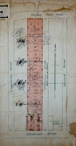
Plan - Subdivision Plan, Thornton Estate, 1918
The ‘Thornton Estate’ was the final subdivision of ‘Thornton’ in Studley Park Road. Thomas Cubitt Balmain originally owned Thornton, next to John Carson’s ‘Clutha’. Before its final subdivision, the Thomson family owned it. The Estate was a subdivision of 15 residential allotments running between Studley Park Road and Stevenson Street. The allotments faced these streets as well as Thornton Street, which the vendor undertook to make. Contemporary newspaper advertisements advised that ‘The estate possesses many advantages, notably its private and secluded, though convenient, position, splendid frontages and depths, and being close to the electric tram and Kew train, also within easy walking distance of the Victoria-street cable tram’. The terms offered purchasers were ten per cent deposit, with the balance to be paid in ten equal half-yearly payments at a rate of 5 per cent.subdivsion plans - kew, studley park, thornton estate -
 Melbourne Tram Museum
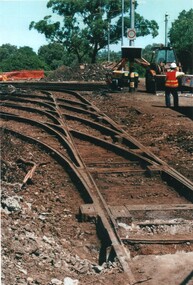
Photograph - Set of 10 Colour Print/s, Steven Altham, 2001
Set of 10 colour prints of the re construction of the Hawthorn Tram Depot to the Watermark Apartments. .1 - Depot fan Trackwork - 6-2-2001 .2 - ditto looking towards tram depot .3 - view towards the building with the second depot demolished, and forecourt excavations underway - 11-3-2001 .4 - Sign on the building advertising apartments .5 - view from street looking at the old depot wall with drilling rigs. .6 - ditto, looking at the worksite for the new block of apartments and part of the original buildings remaining. .7 - Car park slabs being formed. 11-6-2001 .8 - looking at the south wall of the first depot showing the scale of excavation and underpinning. .9 - looking south west/ .10 - Looking from the street at the car park slab in front of the depot. Colliers Jardine and Bovis Lend Lease signs in the photos.All have details of photograph on rear and photographers name.trams, tramways, watermark apartments, hawthorn depot, construction, tram depot