Showing 9255 items matching " tree"
-
 Phillip Island and District Historical Society Inc.
Sketch, 1890
The Cape Paterson shaft at Kilcunda Mine. A landscape - sea and cliffs in the background. A small shed with chimney beside poppet head. Track winding down to three miners. Wooden sheds, all with chimneys. In Foreground a picket fence on cliff on right of picture. A small tree stump on left.The Kilcunda MineCape Paterson Shaft - Kilcundalocal history, photography, photographs, slides, film, kilcunda mine, black & white, pen and ink sketch, miss elms san remo, james stirling -
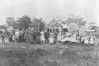 Greensborough Historical Society
Photograph - Digital Image, Greensborough Primary School Gr2062 1907 Arbour Day, 1908_
Informal group photograph of adults and children at Greensborough Primary School, Arbour Day. On Arbour Day individuals and groups are encouraged to plant and care for trees. Arbour Day has been observed in Australia since 1889. There is a newspaper article on 22/06/1907 about Arbor Day.Digital copy of black and white photograph. greensborough primary school, arbour day 1907 -
 Eltham District Historical Society Inc
Photograph, Shillinglaw Cottage
Photograph of print of Shillinglaw cottage with three pine trees in its original location. Shillinglaw Cottage was to be demolished to make way for new Shire of Eltham offices but local community rallying saw the cottage saved and relocated brick by brick to its new location nearby in Panther Place.Roll of 35mm black and white negative film, 1 strip (2 frames)Fuji NP SSeltham, main road, shillinglaw cottage -
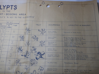 Kiewa Valley Historical Society
Chart - Eucalypts occurring in the Wangaratta, Bright, Bogong Area
On the 2nd April 1948 the SECV noted the Eucalypts in the area of the Kiewa Hydro Electric Scheme. The Forestry Officer was an employee of the SECV and would have given advice in his area of expertise. This chart may have been used with regard to logging and enabling those involved in the identification of the trees.The last row has the heading "Localities and Remarks" and includes those found around the KHES eg. "Tawonga Gap. West Kiewa. Bogong Creek & up to 5 mile peg on Kiewa Valley Road. 7-12 Mile on Mt Buffalo Rd." Also significant to compare these eucalypts with current locations and numbersLarge chart with black print and pictures on yellowing thick paper. The chart has 18 headings across the top and 24 eucalypts listed under the headings.Printed in the bottom right hand corner "Compiled by W.G. Chandler / Forestry Officer / State Electricity Commission of Victoria / 2-4-48"forestry, w.g.chandler, eucalypts in bogong area -
 Robin Boyd Foundation
Document - Manuscript, Robin Boyd, The Rape of Nareeb, 1965
Discusses the Estate of Nareeb, Kooyong Rd; 1888. The National Trust is disinterested, land denuded and house demolished, and there is needless destruction of natural and historic relics for redevelopment, particular destruction of trees exclusive to Australia. Boyd says it shows no consideration for future residents; innocence and undemanding passivity of consumers.Original manuscript of an article published as 'The Rape of Nareeb' in The Australian in 06.03.1965.Typewritten, quarto, 6 pagesnareeb, kooyong rd; national trust; destruction of natural historical environment; redevelopment, robin boyd, manuscript -
 University of Melbourne, Burnley Campus Archives
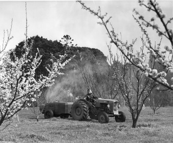
Photograph - Black and white print, Information Branch Victorian Department of Agriculture, Student Spraying in the Orchard, c. 1967
Date estimated from Ref. No. Note by T.H. Kneen 4 March 1992, "Ferguson tractor drawing modern (Auto) mist spraying plant. Operator wearing protective clothing. The prominent tree on the left is Cupressus macrocarpa planted 1857. Note also emergent Araucaria spp."Black and white photograph. Student driving a tractor in the Orchard in Spring. Automatic spraying machine on a trailor. Student wearing protective gear.On reverse, "Photograph by Information Branch Victorian Department Of Agriculture Ref. No. D1101 F."ferguson tractor, mist spraying plant, machine operator, protective clothing, cupressus macrocarpa, araucaria spp., student working outside, orchard, auto mist spraying plant, tractor, publicity -
 Mt Dandenong & District Historical Society Inc.
Photograph
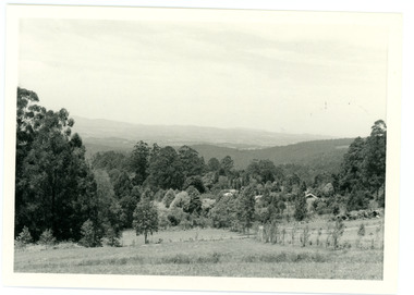
In 1913 Edgar Dower took a photograph from this spot on Ridge Road that became known as Point Clear showing the Mt Dandenong township behind a stand of tall, dead trees. John Lundy-Clarke took this photograph from a similar spot at the Mt Dandenong Arboretum in 1975.Black and white photograph showing a cleared area in the foreground with young tress in the centre and hills in the distance. Several rooftops can be seen mid photo on the right. Reverse of photograph has handwritten description by John Lundy-Clarke.1975 View from the Arboretum over Mt D'nong township at the spot where Edgar Dower took the 1913 photo. The Falls gully is in the middle distance. Peter Damman's fence running downhill right foreground.edgar dower, point clear, mt dandenong, john lundy-clarke, peter damman, arboretum -
 Ballarat Tramway Museum
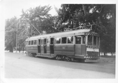
Photograph - Tram 40 Gardens Loop, 1/1966
Photograph - Black and white of Ballarat tram No. 40 parked at Gardens Loop in Wendouree Parade. In the background are the large trees that were a feature of this location. Not known who took the photo during Jan. 1966. Note the two numbers on the front of the tram, as result of the installation of the dash canopy lighting.Yields information about the appearance of tram No. 40 during Jan 1966 and Gardens Loop.Black and white photograph on Ilford paper.In ink on rear "Gardens 1/66"tramways, tram 40, wendouree parade, gardens loop, tramcars -
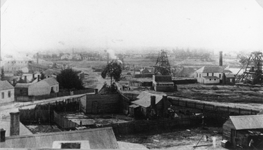 Stawell Historical Society Inc
Photograph, Oriental Gold Mining Company c1880's. Mining Scene looking North probably from Fire Station Tower
Mining Scene looking North probably from Fire Station. Grant and Lamont's Battery in corner left side, in background of photograph. In Centre right is No1 North Cross Reef Mine. On left behind the tree is No2 North Cross Reef Mine. On right is Oriental Mine.Houses and yard in foreground. Poppet heads to right of centre and right Crushing Battery on left of image.stawell mining -
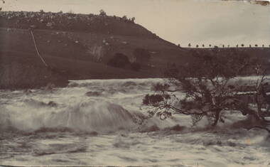 Sunbury Family History and Heritage Society Inc.
Photograph, Jacksons Creek
The photograph of the waterfall tumbling over rocks in the Jacksons Creek are a feature downstream from the Macedon Street bridge and Craiglee when the there has been high rainfall. The steep escarpment on the LHS leads to Jacksons Hill and the line of trees in the distance are growing along Macedon Street (Sunbury Road).After heavy rainfall, Jacksons Creek rises suddenly and small trickles over the rocky outcrops become fast flowing waterfalls.A non-digital sepia photograph backed onto thick cardboard of a waterfall tumbling over rocks in a river with a high escarpment rising up from the watercourse. There are rocky outcrops across the hillside with a pipe down the hillside. jacksons creek, jackson hill, waterfalls, rivers -
Ballarat Tramway Museum
Photograph - Tram 17 & bogie tram at Sturt & Lydiard Sts, Circa mid-late1950s
Photograph shows Tram 17 and an unidentified bogie tram, facing Westbound at the Sturt & Lydiard Sts Tram Stop. The Tram Stop Shelter can be seen located in the road central reservation and is heavily shaded by trees. Destination of No.17 is Bell St. Circa mid-late 1950s. Yields information about tram 17 at Sturt & Lydiard St.Black and white print on plain paper.tramcars, trams, secv, tram 17, sturt st, lydiard st, tram stop -
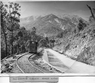 Kiewa Valley Historical Society
Photo - Bogong Creek Race Line
The SECV constructed the Kiewa Hydro Electric Scheme which included race lines to catch the water and feed it into the dams that they built to create hydro electric power. The rail line was used to construct the race line and enables the race line to be easily checked for maintenance eg. fallen trees The SECV constructed the Kiewa Hydro Electric Scheme from the late 1940s to 1961 being one of the first hydro schemes and hence environmently friendly.Shiny black and white photo showing the railway track, with a locomotive on it, beside the race line. Snow is on the surrounding mountains. ;Bogong Creek Race Line in pen and attafhed to the photo. On the back "Property of / State Electricity Commission of Victoria/ Publicity photo / Permission to Publish must be obtained / and acknowledgement made. / Negative No. 14-138bogong creek race line, kiewa hydro electric scheme -
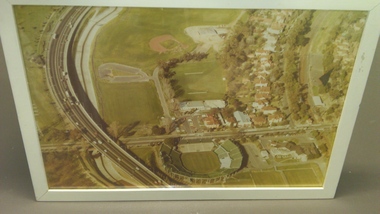
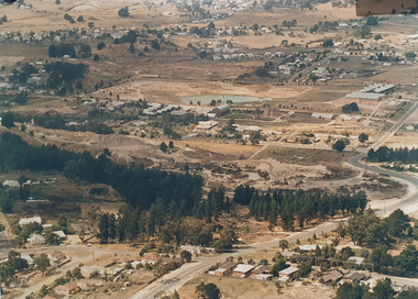
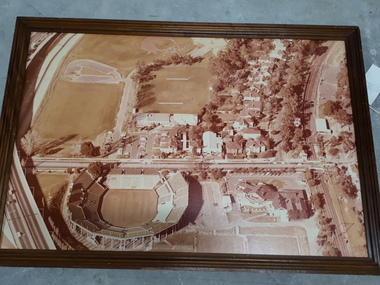 Vision Australia
Photograph - Image, Association for the Blind offices in Kooyong aerial view
Aerial view of Kooyong. The Kooyong Tennis Centre, Glenferrie Road, train station, Talbot Crescent, Monash Freeway and parklands are clearly visible. Few trees are lining the roadway around the sporting fields, the Glenferrie Road building has not expanded and the Blind Cricket pavilion is not yet built. Aerial photograph in brown frame.association for the blind, kooyong tennis centre -
 Vision Australia
Photograph - Image, Association for the Blind offices in Kooyong aerial view
Aerial view of Kooyong. The Kooyong Tennis Centre, Glenferrie Road, train station, Talbot Crescent, Monash Freeway and parklands are clearly visible. Few trees are lining the roadway around the sporting fields, the Glenferrie Road building has not expanded and the Blind Cricket pavilion is not yet built. Aerial photograph in white frameassociation for the blind, kooyong tennis centre -
 Phillip Island and District Historical Society Inc.
Booklet, Phillip Island Holidays Development Pty Ltd, Ideal Summerland on the Nobbies, Phillip Island, Late 1920s
Subdivision of Summerland commenced in the 1920s with 12 large allotments created, along with features such as a roundabout and cypress trees. Between 1927 and 1931, 227 new blocks were created, and from 1929 to 1940 there was a nine-hole golf course on what is now the Penguin Parade car park.Historical Large 8 page glossy booklet advertising Summerland Estate, describing attractions of the area ,maps, houses , golf course. Basically black and white with some orange print and a coloured map.Ideal Summerland on the Nobbies Phillip Island. "The land of somewhere we long to go". Published by Phillip Island Holidays Development Pty Ltd. 6o Market Street, Melbourne.housing, tourism phillip island, summerland estate -
 Mt Dandenong & District Historical Society Inc.
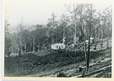
Photograph, Walker's LOT 2
Lot 2 was bought by Harry Walker in the early 1900s. Harry was married to Eva Hand, one of the six daughters of Thomas and Eliza Hand. Harry cleared the land and planted half with raspberries that remained productive until c1928. Harry's son William took over the property. The land was cut in half when the new CRB road went through in the early 1920s. John Lundy-Clarke grew up in the Kalorama/Mt Dandenong area and later in life (1972-74) began to write a comprehensive history of the area working from an original settlement map in an effort to cover all areas.Black and white photograph showing a single storey white house in the centre surrounded by crops. Handwritten description on reverse by John Lundy-Clarke.VIEW 1908 OVER LOT 2 SECTION 1 VILLAGE SETTLEMENT. TAKEN FROM RIDGE ROAD THEN MAIN ROAD FROM HALFWAY BETWEEN MOUNTJOY AND FALLS RD. CRB MAIN RD RUNS BEHIND WALKER’S HOUSE. The house seen in the vista among the tall trees beyond the raspberry patch is “Forest Edge” which was George Barber’s home when the picture was taken. The tall trees to the right of the vista were on Price’s LOT 18 and it was while cutting up one of these for firewood that a length of log weighing about ½ a ton got away downhill and leaped in one bounce over Barbers Road and Logan’s house – 1931.harry walker, william walker, eva hand, crb road, raspberries, kalorama -
 Mt Dandenong & District Historical Society Inc.
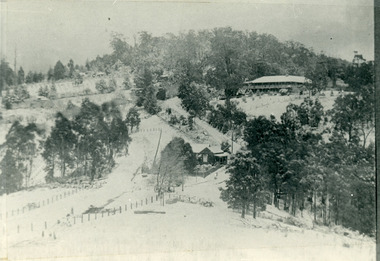
Photograph, The Gap Under Snow 1921, 1921
Snow scene looking up through The Gap (FiveWays) with Mountjoy Guest House on the hill to the right. The shop and post office are seen in the centre of the picture. This photograph has a detailed inscription on the back handwritten by John Lundy-Clarke in 1974.The Gap under snow 1921. “Mountjoy” on hill. New CRB road formation (unmetalled) comes into picture lower left corner, passes left of dray under the elms, then circles around behind the trees behind Miss Hands shop and home and Post Office (Mt Dandenong North) to pass out of picture left in centre of picture. It passes between Ted Prices Hay & Corn store and Walker’s house where the Estate Agency was later placed. Main Road then in centre of picture bend right behind Mountjoy. Price’s house and shop behind the blackwood left of road bend. CRB cuts across Barbers left of Elm trees.john lundy-clarke, kalorama, mountjoy, mountjoy, the gap, post office, mt dandenong north, snow -
 Clunes Museum
Photograph
.1 BLACK AND WHITE PHOTOGRAPH OF CLUNES TOWNSHIP - FRASER STREET FROM CAMP PARADE C 1897 .2 BOOKLET WITH CREAM COVER TITLE: "A COLLECTION OF HYMNS AND SOLOS FOR SUNDAY SCHOOL ANNIVERSARIES" .1 On Reverse; CLUNES FROM CAMP PARADE ABOUT 1897 On Front; Handwritten in blue ink Port Phillip Hotel - Clunes - From Camp Parade 1895-1900 *Note growth of trees along creek. Planted about 1879 to 1880. Seven Stars Hotel at bend in Fraser Streetlocal history, photography, photographs, clunes township -
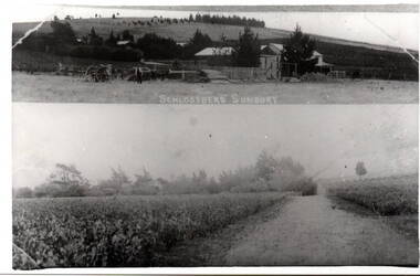 Hume City Civic Collection
Photograph, Schlossberg Vineyard, 1909
Schlossberg Vineyard was situated along Vineyard Road in Sunbury, between Winilba and the Calder Highway. It was established by Felix Frederick Bubeck, who arrived in Australia from Rotenberg (near Stuggart) in the 1860. In 1866 he acquired 60 acres of land on Bald Hill and established the vineyard. In 1880, claret produced on the property received an honourable mention when it was exhibited in Bordeaux, France,From the mid 1850s a number of vineyards were established on the hillsides overlooking Vineyard Road. The east facing outlook that captured the morning sun was ideal for growing grapevines. Other vineyards were also established in the area at the same time.A black and white copy of a postcard of two photographs mounted on the one card with the original handwritten message photocopied on the back. To my dear brother & sister with love and good wishes for a Merry Xmas & a prosperous 1909. Thanks for the paper Your loving sister Marie. You will think it a good photo You will see the trees have grown almost hiding the house. Mr. A Senling, Cheetham St. Kalgoorlie Sth. WAfelix frederick bubeck, schlossberg vineyard, bald hill, vineyards -
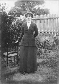 Stawell Historical Society Inc
Photograph, Mrs Ede Sowden in the Raitt garden in Upper Main Street Stawell
Portrait of lady in garden beside chair. Noted Aunty Ede passed away 1940. Mrs Ede Sowden was taken in the Garden of the Raitt home upper Main Street.Lady dressed in a dark coloured suit, white high-necked blouse with brooch at centre, standing beside a chair in the garden. Picket fence is in the background.on the back: Nov '83 Lemon tree has just been removed at property of Mrs Raitt , Upper Main Beverley Biggs (possibly Briggs) has the chair - this is her grandma's sister. Family home brought from Creswick by bullock dray. On the front: Auntie Ede passed away 1940stawell -
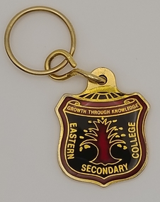 Ringwood and District Historical Society
Ephemera, Douglas Badges (https://www.douglasbadges.com.au/), Easern Secondary College Key Ring with attached Badge (Post 1990), Post 1990
Metal Key ring with attached badge in the form of Eastern Secondary College shield. (Year unknown but Post 1990 as school was renamed late 1990)On Front of Badge: "Eastern Secondary College" around image of tree with motto "Growth Through Knowledge" banner at top. On reverse of Badge: "EASTERN SECONDARY COLLEGE" / "FORMERLY" / RINGWOOD TEHCNICAL SCHOOL" / "1958-1993" / "35 YEARS OF CARE" / "AND EXCELLENCE' Manufacturer's name is Douglas Badges stamped into reverse of badge. rts, ringwood tech, esc -
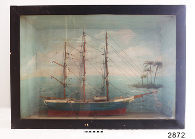 Flagstaff Hill Maritime Museum and Village
Craft - Ship Model, Auster
Ship model, Auster relief, 3 masted sailing ship, teal colour. Background of sea and sky, island with palm trees, seagulls. Front wood frame of case painted black, back and sides painted grey. Metal handle on top panel of case. "AUSTER" painted on side of bowflagstaff hill, warrnambool, shipwrecked-coast, flagstaff-hill, flagstaff-hill-maritime-museum, maritime-museum, shipwreck-coast, flagstaff-hill-maritime-village, ship mode., auster, sailing ship -
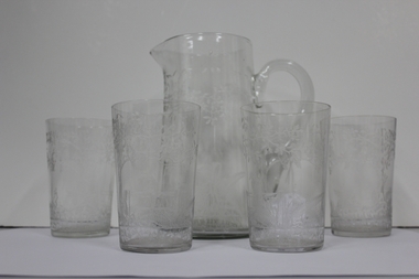 Ringwood and District Historical Society
Domestic object - Jug and Glasses, Vintage glasses and pitcher set
Jug and four glasses, each item with hand etchings of Australian fauna and flora - kookaburra sitting on a post and rail fence; kangaroos; and tree ferns:; 1. Glass Jug with handle and spout.; 2-5. Glasses +Additional Keywords: O'Connor, Neville / O'Connor, Ian -
 Bendigo Military Museum
Photograph - PHOTOGRAPH, FRAMED WW1, Wayne Eels, C.2008/09
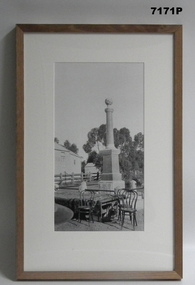
The Grinton Collection. Taken at the opening of the Macorna War Memorial on 5.3.1920. refer Cat No 5890P for more details. Jack Grinton. Refer Cat No. 1280 for his service history.Photograph - framed. Photograph - black and white photograph on paper depicts the "Macorna War Memorial" - globe upon a column with a square base. Foreground - table and chairs, background timber buildings and trees. Frame - Timber. light varnish finish, Perspex front, cardboard backing."Single Photos Group 2 (end of show): Opening of Macorna War Memorial".framed accessories, camera on the somme, ww1, 38th bn, grinton -
 Bendigo Military Museum
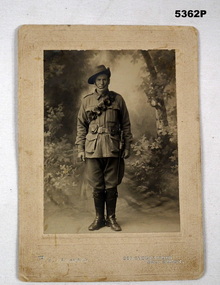
Photograph - PHOTOGRAPH WW1, Yeoman & Co, C.1914
This is possibly John James Barnes born Marong, No 487 enlisted on 8.9.1914 in 8th L.H Machine Gun sectionSepia tone photo showing a soldier with slouch hat, bandolier over shoulder and bayonet on belt standing in a studio setting of a tree and shrubs, photo is set on a cream coloured ornate card. The photographers details are across the bottom in gold lettering. There are a number of inscriptions on the rearOn rear in black pen, “Mr J.J.Barnes Marong”, in blue pen, “To aunt, uncle and cousins with love from Barney, (dates unclear) 1914”photographs, l.h, -
 Bendigo Military Museum
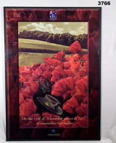
Poster - POSTER, MOUNTED, The Public Affairs Unit of the Dept of Veteran's Affairs
Coloured picture of red poppies with fields, trees & sky in background. A slouch hat with Rising Sun badge is with the poppies at the bottom centre. Poster is covered in clear plastic & has a brown border & is mounted on chipboard with black border. Short white hanging strap at back.Emblem at top centre: “THEIR SERVICE OUR HERITAGE” Printed at bottom centre: “On the 11th of November pause at 11..... to remember the fallen”poster, remembrance day -
 Federation University Historical Collection
Photograph, Site of Sovereign Hill and Ballarat Lodge
The Old Ballarat Travel Inn was located at 613 Main Road. It later Became Ballarat Lodge and Mecure Ballarat.Photograph showing the site of Sovereign Hill in fron to the pine trees, and Elsmore street running along the right. Ballarat Lodge, the brainchild of John Gilbert, can be seen in front of the dam in the centre. The start of Magpie Street can be seen on the left hand side of the photograph.ballarat lodge, john gilbert, sovereign hill, elsmore street, main road, ballarat east, old ballarat travel inn -
 Bendigo Military Museum
Memorabilia - TAPESTRY, FRAMED, Post WW1
Timber frame, gold with black highlights, glass front. Egyptian scene tapestry with 3 civilians collecting & using water in foreground, palm trees mid ground, buildings & a number of civilians in background. Colours - browns, yellows, black, pale blue, white & greens. handcrafts-tapestry, frame accessories, eygpt -
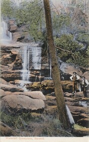 Halls Gap & Grampians Historical Society
Postcard - Coloured
This postcard was printed in Germany and hand coloured. The name of the waterfall is not givenPostcard showing two men, with hands on hips, standing beside a waterfall. The waterfall flows over two rock ledges. Both men are wearing hats. A tree stands almost centre foreground and runs to the top of the card. The postcard has been hand coloured.Waterfall Grampians, Stawell printed on the bottom of the postcard in red.scenery, waterfalls