Showing 11019 items
matching various.
-
 Eltham District Historical Society Inc
Photograph, Peter Bassett-Smith, Unveiling ceremony of the Memorial Plaque at corner of Main Road and Pitt Street, Eltham commemorating the 20th Anniversary of Eltham District Historical Society, 10 October 1987, 10/10/1987
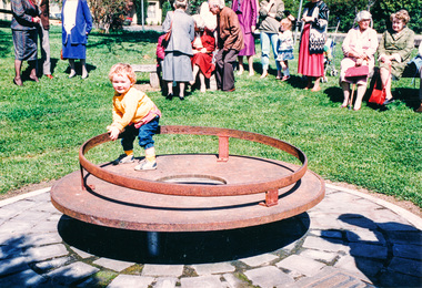
Shire of Eltham Historical Society Monument commemorating Victoria’s 150th Anniversary. The monument consists of a ‘Tyring Disc’ surmounted by a steel tyre standing over a Time Capsule to be opened in the year 2035. The commemorative plaque explains the functions of the various items used in the Victorian 150th Anniversary Monument and Time capsule.Colour photograph and sepia photograph1987, activities, eltham community centre, time capsule -
 Glen Eira Historical Society
Document - Hotels, Caulfield
This file contains one item: 1/Handwritten research notes recording details about various hotels in the Caulfield area and environs. Details include handwritten maps and lists of publicans/licensees/nominees. Notes by author unknown and undated. Some of the notes make reference to entries in Sands & McDougall directories.r. k. cole hotel collection, london tavern hotel, london tavern and store, glen huntly road, caulfield, sycamore street, hawthorn road, dandenong road, derby road, koornang road, caulfield club hotel, rosstown hotel, royal hotel, the vine beer house, the vine caulfield hotel, newton h., balaclava road, bambra road, mirrambeena road, murrumbeena road, poath road, the tam o’shanter hotel, wilston street, farmers’ arms home hotel, chestnut street, hooper street, thompson william, martin p. j., orme frederick, orme fred, nicholls william henry, mullins john, armstrong john, egan james, westwood james, westwood ellen, greenberg david, greenberg sydney, greenberg rose, spamm cath, pitter mabel, morrow andrew, morrow andy, feddan george curtis, guess john, evans rowland, evans roland, riordan john, smith george elms, bedwell c., griffen frederick, connelly p. h., uhrbrock f., swift charles, gregor f., hazlett david, moore l., harley susan, mott h., nichols william henry, ross peter mclean, elsternwick, mcnamara margaret, mcnamara v., stevens catherine, mcgregor f., clarice george -
 Tatura Irrigation & Wartime Camps Museum
Document, Twenty newspaper and other extracts
Twenty newspaper and other extracts. Photograph 1 & 2. Newspaper articles on interview Archie Wilson with Tom Nevett. Various newspaper articles on John West, rate book information. Photograph 14. Log hut on J. D. Love's property. Photograph 15. Log and other early fencing. -
 Stawell Historical Society Inc
Photograph, Free Methodist Chapel Church in Wakeham Street 1870 -- Coloured
Coloured photograph of Church built in Wakeham Street Stawell in 1870 and used as a Free Methodist Chapel. After the various branches of the Methodist Church united about 1900 the building was used by the Free Masons until their building in Skene Street was erected in 1926. It's now the home of the Stawell Municipal Band.Colour photograph depicting a Church (brick) building with a timber fence around the back section of the church. -
Bialik College
Photograph (Item) - School Photographs of the 1990s, various events
School photographs from Bialik College, showing students and teachers going about various activities from the 1990s. A large collection of photographs came from 1994. These concentrate on music and drama events, but there are some classroom tasks like origami box making. For inquiries or access contact [email protected], visual and performing arts, music, drama, 1990s, 1994, 1999, 1991, school, jewish school, bialik college, photographs -
 Hume City Civic Collection
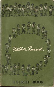
Book - School Reader, Education Department of Victoria, Gather Round/Fourth Book, 1965
A school reader for Grade 4 children.A bound school reader with a soft dark green cloth cover with lettering and diagrams in black and white. Both front and back covers are decorated with lines and circles of children holding readers. Inside there are 248 pages containing stories, poems and illustrations. fictionA school reader for Grade 4 children.school readers, gather round, grade 4, education department of victoria, a.c. brooks, government printer -
 Robin Boyd Foundation
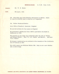
Document - Memorandum, M B (Romberg and Boyd) to Robin Boyd, 08.04.1960
This is a Romberg & Boyd memo to Robin Boyd regarding details relayed in telephone phone call M.B. had with Mr John Islip regarding a Mr Walter Richmond Butler, an architect, born in England in 1864 and practiced in Melbourne from 1889-1949, with information regarding the architectural practice's various names. -
 Sunbury Family History and Heritage Society Inc.
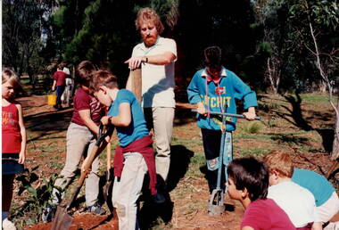
Photograph, Arbor Week celebration, 26th - 28th April 1989
The children at Bulla Primary School were celebrating Arbor Week in 1989 by improving the school garden. Three boys are digging a hole for a pole which will support a sign while their teacher Mr. Jolly is holding the post in an upright position. During that week the children worked on various parts of the school garden.A non-digital coloured photograph of three children digging in a garden with four others looking on and an adult supervising thew work.arbor week, mr. jolly, gardens, bulla primary school -
 Vision Australia
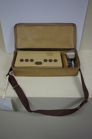
Machine - Object, APH Pocket Braille
American Printing House pocket brailler consisting of a rectangle shaped structure made out of a brown coloured plastic with 7 keys and 3 buttons and a mustard coloured vinyl cover with attached handle and a power cord. Braille letters are achieved by punching the various keys. Serial number: Louisville 1354.Brown coloured plastic rectangular Brailler with covering vinyl bag with handle.braille equipment, assistive devices -
 Vision Australia
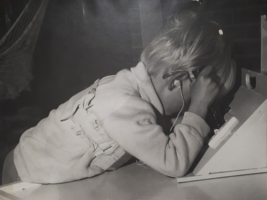
Photograph - Image, Hand eye co-ordination in children
A blonde haired boy with glasses and earphone attached to a device strapped to his body, manipulates various boxes with a handle and openings in it. On one box is written 'Not be used without adult supervision'. The wooden boxes are homemade and most likely used at the Burwood school to assist teachers in developing coordination skills in their students.3 digital images of a blonde boy with glasses and a hearing aidrvib burwood school, occupational therapy -
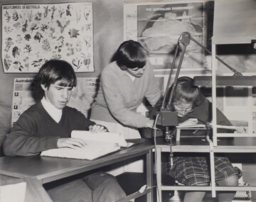 Vision Australia
Photograph (item) - Image, Burwood schoolchildren reading
Burwood School children undertook reading in various ways, such as Braille, and using aids such as additional lighting and a reading platform. In this example, a boy reads Braille whilst a girl is assisted by a teacher to read from her book. In the background are three posters displaying the wildflowers, environment and another aspect of Australian studies.burwood school, education, braille -
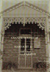 Harcourt Valley Heritage & Tourist Centre
Book, Granite Houses of Harcourt & Faraday, 2014
When the Harcourt Valley was the subject of route selection /environmental effects survey in connection with the upgrade of the Calder Highway into Freeway the Harcourt Valley Heritage Committee enumerated and researched the unique collection of granite homes to be found in the valley. The publication gives a short account of the builders and illustrates the various techniques of building in stone. Advocacy by the Harcourt Valley Heritage Committee ensured the retention, in the face of demolition threat, of a unique collection of homes, many owner-built and of vernacular architecture. A4 size book of 42 pages with full colour ilustrationsGranite Houses of Harcourt & Faraday -
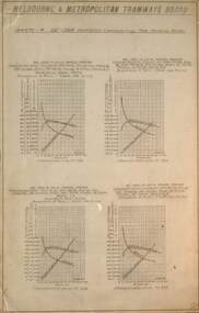 Melbourne Tram Museum
Document - graph, Melbourne & Metropolitan Tramways Board (MMTB), GE264 Motor performance curves, 1922
Provides information on the GE 264 Ventilated Commutating Pole Motor, prepared by the MMTB dated 4/8/1922. Gives graphs for various gear ratios and wheel sizes. Would have been used for gear and wheel size selection. This type of motor was used in X 217 - see reference.Yields information about the motor used in Birney X 217Document printed on foolscap paper.tramways, technical information, tramcars, electrical equipment, motors, x class, tram 217 -
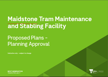 Melbourne Tram Museum
Document, Maidstone Tram Maintenance and Stabling Facility - Proposed Plans - Planning Approval, 2022
Provides the proposed plans for the Maidstone Tram Maintenance and Stabling Facility - Proposed Plans - Planning Approval stage - site plans, perspective, land use and sight lines from various locations. The information booklet looks at the project steps, planning approval, heritage issues, environmental, construction, timing and operations.Yields information about the proposed Maidstone tram depot.Digital copy of a 13 A3 page document titled - Maidstone Tram Maintenance and Stabling Facility - Proposed Plans - Planning Approval and a 12 A4 page Information booklettrams, maidstone, tramways, new depot -
 Ringwood and District Historical Society
Archive, Ringwood Technical School / Eastern Secondary College Archive Collection of Photographs and Documents 1958 -1993 (Parent Record)
Ringwood Technical School was the first co-educational technical school in Victoria. In 1963, 229 Form 1 students were enrolled, being the biggest student intake so far in the school’s 5 year history, bringing the school population close to 700 in Forms 1 to 4. Extensions to the 3 year old building were under way to cope with the increasing student numbers. Experienced teachers came from all parts of the State to teach in this unique school, The school was known locally as Ringwood Tech School, Ringwood Tech, Ringy Tech, Ringers Tech, The Tech and RTS. It began in 1958 with Form 1 boys, then Form 1 girls in 1959 at a separate campus. Both groups were hosted at district schools until 1960, when the new school was completed at Heathmont. It was the first co-ed technical school in Victoria. The school underwent several name and role changes in later years, and finally closed in 2003.This is the parent record for the large archives collection of Ringwood Technical School (later Eastern Secondary College), consisting of class and group photos, trip and other photos, and various documents and magazines from the school's beginning in 1958 to its closure in 1993. Individual items fall in the VC Reference Number range 21001 - 22899 and where possible are grouped by year. At 5/3/2021 the bulk of the collection is being catalogued ready for a bulk load to Victorian Collections. rts, ringwood tech, ringwood technical school, eastern secondary college, ringwood tech school -
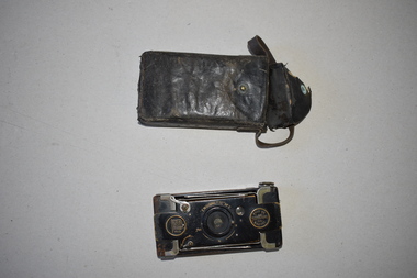 Warrnambool and District Historical Society Inc.
Camera, Eastman Kodak Co, Vest Pocket, 1920s
This camera, made by the American firm of Eastman Kodak, was the best-selling folding camera during the first half of the 20th century. This is the ‘autographic’ model as there is provision at the back of the camera for note-taking. This model was made between 1915 and 1926 and it is called the soldier’s camera because of its compact size. Over 1,000,000 cameras of this type were sold during World War One. This camera belonged to C.C. McNeil of Caramut, a town 55 kilometres north of Warrnambool. This camera is of interest as it belonged to a person from the Warrnambool district and it is a good example of a pocket camera with note-writing facilities. This is a black metal camera in a rectangular shape with rounded edges. It has three glass apertures and a metal winder. It also has an opening shutter at the back of the camera where notes can be written on to the paper backing of the film. The front of the camera opens and a concertina-like metal attachment affixed to the back of the camera can be pulled out to reveal the lens. This is covered in black leather. Printed information etched into the surface can be found in various locations around this camera. Vest Pocket Autographic Kodak U.S. Patents – Mar 4 1902, May 6 1913 Eastman Kodak Co. Rochester N.Y. U.S.A. Celia C. McNeil Caramut 20th century photography, history of warrnambool -
 Eltham District Historical Society Inc
Negative - Photograph, J.A. McDonald, Eltham-Yarra Glen Road, Lower Plenty footbridge, Sep. 1955
The Eltham-Yarra Glen Road as designated originated at the Shire of Eltham boundary at the Plenty River. West of the river the road was known as the Heidelberg-Eltham Road. The section from the Plenty River is now known as Lower Plenty Road which becomes Main Road. The footbridge no longer exists but was originally sited to the south, adjacent to the old Lower Plenty Bridge, now part of the Plenty River Trail. Record of various Shire of Eltham infrastructure works undertaken during the period of 1952-1962 involving bridge and road reconstruction projects, sometimes with Eltham Shire Council Project Reference numbers quoted. It was during this period that a number of significant improvements were made to roads and new bridges constructed within the shire that remain in place as of present day (2022). In many situations, the photos provide a tangible visible record of infrastructure that existed throughout the early days of the Shire. The album was put together by or under the direction of the Shire Engineer, J.A. McDonald.1955-09, eltham-yarra glen road, lower plenty footbridge, lower plenty, lower plenty bridge, lower plenty road, main road, plenty river trail, bridge construction, infrastructure, shire of eltham -
 Eltham District Historical Society Inc
Negative - Photograph, J.A. McDonald, Eltham-Yarra Glen Road, Lower Plenty footbridge, Sep. 1955
Tony Carberry and J. Jolly The Eltham-Yarra Glen Road as designated originated at the Shire of Eltham boundary at the Plenty River. West of the river the road was known as the Heidelberg-Eltham Road. The section from the Plenty River is now known as Lower Plenty Road which becomes Main Road. The footbridge no longer exists but was originally sited to the south, adjacent to the old Lower Plenty Bridge, now part of the Plenty River Trail. Record of various Shire of Eltham infrastructure works undertaken during the period of 1952-1962 involving bridge and road reconstruction projects, sometimes with Eltham Shire Council Project Reference numbers quoted. It was during this period that a number of significant improvements were made to roads and new bridges constructed within the shire that remain in place as of present day (2022). In many situations, the photos provide a tangible visible record of infrastructure that existed throughout the early days of the Shire. The album was put together by or under the direction of the Shire Engineer, J.A. McDonald.1955-09, eltham-yarra glen road, lower plenty footbridge, j. jolly, lower plenty, lower plenty bridge, lower plenty road, main road, plenty river trail, tony carberry, bridge construction, infrastructure, shire of eltham -
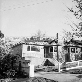 Eltham District Historical Society Inc
Negative - Photograph, J.A. McDonald, Newly built home, Sep. 1955
Street and location unidentified, possibly not Eltham though next immediate frame is Pryor Street and sun position appears to be similar indicating street (ealrly to mid afternoon) indicating street runs east west direction and camera view is to the south. Streets in Eltham are all even numbered on the south sideRecord of various Shire of Eltham infrastructure works undertaken during the period of 1952-1962 involving bridge and road reconstruction projects, sometimes with Eltham Shire Council Project Reference numbers quoted. It was during this period that a number of significant improvements were made to roads and new bridges constructed within the shire that remain in place as of present day (2022). In many situations, the photos provide a tangible visible record of infrastructure that existed throughout the early days of the Shire. The album was put together by or under the direction of the Shire Engineer, J.A. McDonald.1955-09, houses, shire of eltham -
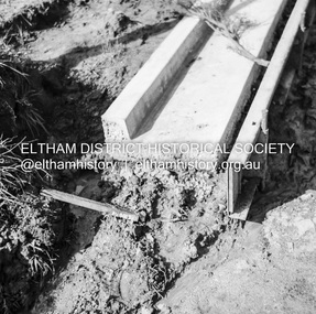 Eltham District Historical Society Inc
Negative - Photograph, J.A. McDonald, Eltham, Pryor Street, Sep. 1955
Construction of new concrete kerbing and footpath in Pryor Street, Eltham 18” tray and AG backing(?)Record of various Shire of Eltham infrastructure works undertaken during the period of 1952-1962 involving bridge and road reconstruction projects, sometimes with Eltham Shire Council Project Reference numbers quoted. It was during this period that a number of significant improvements were made to roads and new bridges constructed within the shire that remain in place as of present day (2022). In many situations, the photos provide a tangible visible record of infrastructure that existed throughout the early days of the Shire. The album was put together by or under the direction of the Shire Engineer, J.A. McDonald.1955-09, footpaths and gutters, pryor street, infrastructure, shire of eltham -
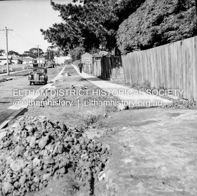 Eltham District Historical Society Inc
Negative - Photograph, J.A. McDonald, Eltham, Pryor Street, Sep. 1955
Construction of new concrete kerbing and footpath in Pryor Street, Eltham The truck on the left of the road is parked ouside the Eltham Police Station at No. 23. On the right is the present-day Woolworths carparkRecord of various Shire of Eltham infrastructure works undertaken during the period of 1952-1962 involving bridge and road reconstruction projects, sometimes with Eltham Shire Council Project Reference numbers quoted. It was during this period that a number of significant improvements were made to roads and new bridges constructed within the shire that remain in place as of present day (2022). In many situations, the photos provide a tangible visible record of infrastructure that existed throughout the early days of the Shire. The album was put together by or under the direction of the Shire Engineer, J.A. McDonald.1955-09, footpaths and gutters, pryor street, eltham police station, infrastructure, shire of eltham -
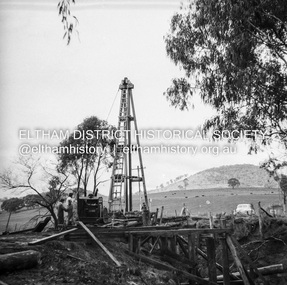
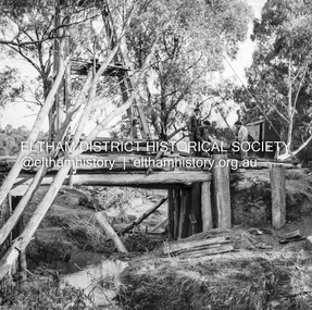 Eltham District Historical Society Inc
Negative - Photograph, J.A. McDonald, Pinnacle Lane, Steels Creek, Sep. 1955
The old bridge looking downstream Record of various Shire of Eltham infrastructure works undertaken during the period of 1952-1962 involving bridge and road reconstruction projects, sometimes with Eltham Shire Council Project Reference numbers quoted. It was during this period that a number of significant improvements were made to roads and new bridges constructed within the shire that remain in place as of present day (2022). In many situations, the photos provide a tangible visible record of infrastructure that existed throughout the early days of the Shire. The album was put together by or under the direction of the Shire Engineer, J.A. McDonald.1955-09, pinnacle lane, steels creek, bridge construction, infrastructure, shire of eltham -
 Eltham District Historical Society Inc
Negative - Photograph, J.A. McDonald, Pinnacle Lane, Steels Creek, Sep. 1955
The old bridge looking eastwardsRecord of various Shire of Eltham infrastructure works undertaken during the period of 1952-1962 involving bridge and road reconstruction projects, sometimes with Eltham Shire Council Project Reference numbers quoted. It was during this period that a number of significant improvements were made to roads and new bridges constructed within the shire that remain in place as of present day (2022). In many situations, the photos provide a tangible visible record of infrastructure that existed throughout the early days of the Shire. The album was put together by or under the direction of the Shire Engineer, J.A. McDonald.1955-09, pinnacle lane, steels creek, bridge construction, infrastructure, shire of eltham -
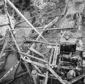 Eltham District Historical Society Inc
Negative - Photograph, J.A. McDonald, Pinnacle Lane, Steels Creek, Sep. 1955
The old bridge from top of pile frameRecord of various Shire of Eltham infrastructure works undertaken during the period of 1952-1962 involving bridge and road reconstruction projects, sometimes with Eltham Shire Council Project Reference numbers quoted. It was during this period that a number of significant improvements were made to roads and new bridges constructed within the shire that remain in place as of present day (2022). In many situations, the photos provide a tangible visible record of infrastructure that existed throughout the early days of the Shire. The album was put together by or under the direction of the Shire Engineer, J.A. McDonald.1955-09, pinnacle lane, steels creek, bridge construction, infrastructure, shire of eltham -
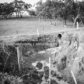
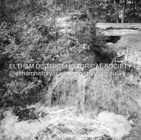 Eltham District Historical Society Inc
Negative - Photograph, J.A. McDonald, Dixons Creek, Sep. 1955
Record of various Shire of Eltham infrastructure works undertaken during the period of 1952-1962 involving bridge and road reconstruction projects, sometimes with Eltham Shire Council Project Reference numbers quoted. It was during this period that a number of significant improvements were made to roads and new bridges constructed within the shire that remain in place as of present day (2022). In many situations, the photos provide a tangible visible record of infrastructure that existed throughout the early days of the Shire. The album was put together by or under the direction of the Shire Engineer, J.A. McDonald.1955-09, dixons creek bridge, dixon's creek road, flood damage, floods, floodwater, infrastructure, shire of eltham -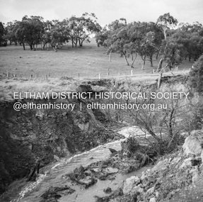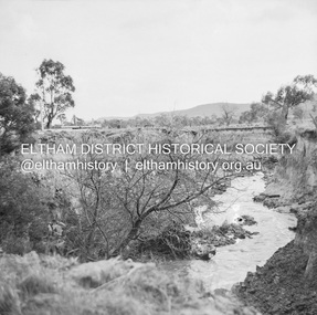
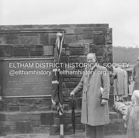 Eltham District Historical Society Inc
Negative - Photograph, J.A. McDonald, Upper Yarra Dam, 26 Nov. 1957
Sir Dallas Brooks following the formal opening of the Upper Yarra Reservoir, 26 November 1957 Upper Yarra Reservoir Opened by His Excellency The Governor of Victoria General Sir Dallas Brooks K.C.B.., K.C.M.G., K.C.V.O., D.S.O., K.St.J. On 26th November, 1957 This tablet also commemortyaes the centenary Of Melbourne's water supply system Yan Yean Reservoir 1857 Upper Yarra Reservoir 1957Record of various Shire of Eltham infrastructure works undertaken during the period of 1952-1962 involving bridge and road reconstruction projects, sometimes with Eltham Shire Council Project Reference numbers quoted. It was during this period that a number of significant improvements were made to roads and new bridges constructed within the shire that remain in place as of present day (2022). In many situations, the photos provide a tangible visible record of infrastructure that existed throughout the early days of the Shire. The album was put together by or under the direction of the Shire Engineer, J.A. McDonald.infrastructure, shire of eltham, 1957-11-26, opening ceremony, plaques, sir dallas brooks, upper yarra dam, upper yarra reservoir -
 Eltham District Historical Society Inc
Negative - Photograph, J.A. McDonald, Upper Yarra Dam, 26 Nov. 1957
Upper Yarra Reservoir Opened by His Excellency The Governor of Victoria General Sir Dallas Brooks K.C.B.., K.C.M.G., K.C.V.O., D.S.O., K.St.J. On 26th November, 1957 This tablet also commemortyaes the centenary Of Melbourne's water supply system Yan Yean Reservoir 1857 Upper Yarra Reservoir 1957Record of various Shire of Eltham infrastructure works undertaken during the period of 1952-1962 involving bridge and road reconstruction projects, sometimes with Eltham Shire Council Project Reference numbers quoted. It was during this period that a number of significant improvements were made to roads and new bridges constructed within the shire that remain in place as of present day (2022). In many situations, the photos provide a tangible visible record of infrastructure that existed throughout the early days of the Shire. The album was put together by or under the direction of the Shire Engineer, J.A. McDonald.infrastructure, shire of eltham, 1957-11-26, opening ceremony, plaques, sir dallas brooks, upper yarra dam, upper yarra reservoir