Showing 909 items matching " railway construction"
-
 Otway Districts Historical Society
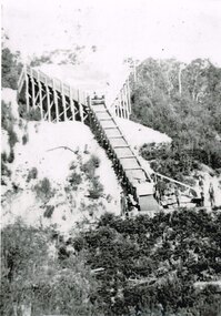
Photograph, Gellibrand Ballast Siding, c.1920
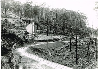
... During construction of the railway in 1901 a ballast siding... Forest great-ocean-road During construction of the railway ...During construction of the railway in 1901 a ballast siding was originally opened 4.5 km south of Barongarook but the ballast proved inferior and a new ballast siding was opened 4 km south of Gellibrand to provide material for track construction. A spur siding, with points facing Beech Forest and a capacity for six trucks, was cut into the side of a slope. Above this was erected a loading bin and chute. This stone was of durable quality so the siding continued in commission after 1902 for periodic track re-ballasting. By the mid-1920s Victoria Railways found it more economic to use ballast from elsewhere so the siding was closed by 1925 and the rails lifted.B/W. Gellibrand Ballast Siding loading ballast down the slope, with five workmen watching at the base.gellibrand; ballast; railways; -
 Otway Districts Historical Society
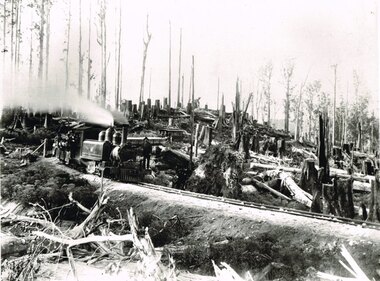
Photograph, Victorian Railways, Between Devitt Bros. Siding & Ditchley, 1901, 1901
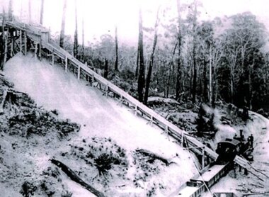
Construction of the Colac-Beech Forest railway line began in 1900 with about 100 men engaged in laying and ballasting the track, as well as others forming the earthworks and building culverts and bridges. The result of this labour saw the railway advance from Colac until it climbed a spur hugging the side of a forty degree slope emerging on top of the ridge at Beech Forest. This photograph was taken 28 miles (45 kilometres) from Colac between Devitt Bros. Siding and Ditchley, just out of Beech Forest. Two 2-6-2 Tank engines of the narrow-gauge A class built by Victorian Railway's Newport workshop, were commonly dubbed 'Coffee Pots'. As well as pulling a load of NQR wagons a NBB saloon car ended the train. The devastation to the standing timber was deliberate: the Engineer-in-Chief of VR ruled that all trees within a certain distance of the railway line were to be cut down. This certainly saved the line from destruction several times in the future.B/W. An NA class locomotive, NQR wagons and an NBB saloon car, all with workmen, going around a bend between Devitt Brother's Siding and Ditchley on the Beech Forest line in 1901.beech forest; ditchley; devitt bros siding, railways; -
 Otway Districts Historical Society
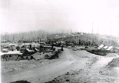
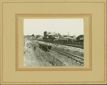
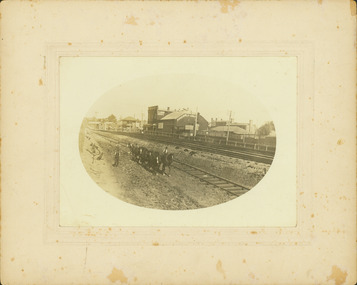
Photograph, Knox Collection, Beech Forest township, c.1903, c.1903
J.W. Gardner erected premises in Beech Forest which formed the core of a village. No further progress was made until access was facilitated though the development of a narrow gauge railway approved by the Victorian Parliament in 1898. Construction commenced in 1900. From this time Colac and Geelong business interests began investment in Beech Forest and established various retail and service establishments over the next few years. In 1902 three early settlers, Gardner, Charles Buchanan and John Cockerill, divided part of their land or bought land which was sold to businesses. On these subdivisions were created saleyards, general stores, a post office, bakery, blacksmithing, banks, a police station and lock-up, a public hall, churches, a state school, bootmaker, butcher, solicitor's office, hairdresser, billiard's saloon and newsagency.B/W. 188mm x 266mm. A general view of Beech Forest township in c.1903.beech forest; township; -
 Otway Districts Historical Society
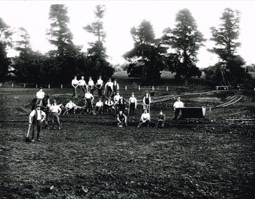
Photograph, Narrow gauge construction camp near Colac, c.1900
... or at open fires. construction camp; railways; colac; B/W. 158mm x ...Construction of the Colac-Beech Forest railway line commenced in 1900 and the first activities were the work gangs and their camps. About 100 men were engaged in laying and ballasting the track while others formed the earthworks and the building of culverts and bridges. The first camp was established eight kilometres from Colac, the second 12 km south, and the remainder spaced at similar distances as the work progressed. The camps were served by butchers and bakers from Colac that visited them as many times each week to satisfy the mens' requirements. Many of the men had their families with them. They all lived in tents that consisted of a wooden floor around which the canvas cover was built. A calico partition divided the eating and sleeping quarters, and all cooking was done in camp ovens or at open fires.B/W. 158mm x 203mm. Near Colac, a narrow gauge construction camp comprising 21 workmen, a horse, and two tipping trays.construction camp; railways; colac; -
 Otway Districts Historical Society
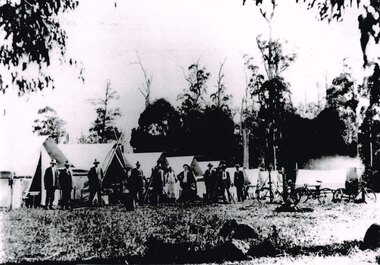
Photograph, Knox Collection, Survey camp for Colac-Beech Forest railway, 1901, 1901
Plans for a rail connection between Colac and Beech Forest had been drawn up in 1884 and 1889 but proofed inconclusive because of the enormous cost involved in building a railway in such difficult terrain. Because of the financial depression in the early 1890s such expenditure went of hold. Towards the end of the decade planners recognised that a narrow gauge could be a viable alternative and it was taken up by the community, Parliamentary representatives and the government, although Victorian Railways administration was against the idea. This was overridden. The 1898 Parliament approved a 2 foot 6 inch gauge from Colac to Beech Forest although strict financial limits were set. The route was to be the most direct and the infrastructure the most basic. Construction began in 1900 entailing very steep grades and myriad curves until it finished in 1902. Surveyors and their assistants came before and during the track laying for the whole distance.B/W. Survey camp for the Colac-Beech Forest railway in 1901, showing nine tents, ten men including a cook, survey instruments, and three bicycles. Note the cooking fire on the right.colac: beech forest; railways; survey; -
 Otway Districts Historical Society
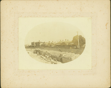
Photograph, Victorian Railways, Gellibrand ballast pit siding, c.1902
In 1902 a ballast siding was opened 4 km south of Gellibrand to provide materials for track construction. A spur siding with a capacity for six trucks was cut into the side of a slope. Above this was erected a loading bin and chute. The stone proved to be of durable quality so the siding continued after 1902 for periodic track re-ballasting works. The points were set for the main line and spiked shut when the siding was not in use. By the mid-1920s the Victorian Railways found it more economic to use ballast from Penshurst, so the siding was closed by 1925 and the rails lifted.B/W. Gellibrand ballast pit siding at 19 miles (30.6 km) south of Colac. gellibrand; gellibrand siding; railways; -
 Otway Districts Historical Society
Photograph, R. Preston, Weeaproinah mallee shed, c.1920, c.1920
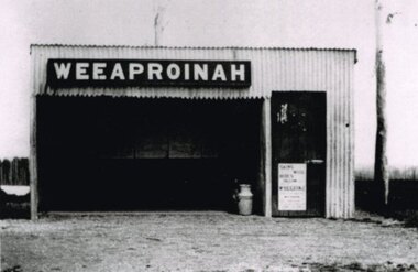
... , this station opened during construction of the Crowes railway on 1 May... selector, this station opened during construction of the Crowes ...Originally named 'McInnes' after a local selector, this station opened during construction of the Crowes railway on 1 May 1911. The name was altered to Weeaproinah, the second station of that name, on 9 December 1912, after the parish in which the station was situated. (The original 'Weeaproinah' on the railway became earlier 'Dinmont' in the Olangolah Parish.) The station comprised a passenger shelter and a loop siding with a ramped platform for a sheep and pig race. A departmental residence was built for a track repairer based at the station, but no station or caretaker staff were employed there. The residence was burnt down during the 1919 bushfire but it was replaced and remained in use as a departmental residence until 1930. Weeaproinah became an unattended crossing station in December 1927 under the Train Section Order system.B/W. Weeaproinah mallee shed. In the shed there are five large wall-mounted posters and a cream can. An unlocked door with a "Skins / Hides" poster gives access the inside. A tree trunk stands to the right.weeaproinah; railways; shed; -
 Otway Districts Historical Society
Photograph, Victorian Railways, Gellibrand Ballast Siding, c.1902, c.1902
In 1902 a ballast siding was opened 4km south of Gellibrand to provide materials for track construction. A spur siding, with points facing Beech Forest and a capacity for six trucks, was cut into the side of a slope. Above this was erected a loading bin and chute. The stone proved to be of durable quality so the siding continued in commission after 1902 for track re-ballasting work. By the mid-1920s Victorian Railways found it more economic to use ballast from Penshurst, so the siding was closed by 1925 and the rails lifted.Photograph; B/W. Gellibrand Ballast Loading Sitegellibrand; ballast; railways; siding; -
 Bendigo Historical Society Inc.
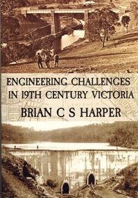
Book - ENGINEERING CHALLENGES IN 19TH CENTURY VICTORIA
... on the construction of the Bendigo Railway Line, Coliban Water Scheme, Lower.... Book includes information on the construction of the Bendigo ...Engineering Challenges in 19th Century Victoria by Brian C S Harper, or Brian Harper, soft cover 256 pages with black and white photographs. Book includes information on the construction of the Bendigo Railway Line, Coliban Water Scheme, Lower Stony Creek Dam, the Saltwater Railway Bridge, and the Taradale Railway Viaduct. Transferred to Specimen Cottage for use June 2016 Missing from Specimen Cottage. Check sale items 8.12.22Brian C. S. Harperbooks, technical, engineering -
 Ballarat Tramway Museum
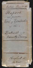
Document - Report, Henry Smith, "Report on probably cost of construction of the Ballarat and Dunolly Tramway", 23/6/1857
Report - 9 pages- handwritten, dated June 23 1857 to the Provincial Committee of the Ballarat and Dunolly Railway" Prepared by Henry Smith Civil Engineer, looks as various aspects of a prolapsed timber rail / sleepered tramway plated, horse drawn, grades, earthworks. Gives a total cost of 2897 pounds. Last page has a ink and washed sketch of the track structure - plan and cross section. Only the cover, first page and last page imaged.trams, tramways, tramways, costs, dunolly, timber tramways -
 Ballarat Tramway Museum
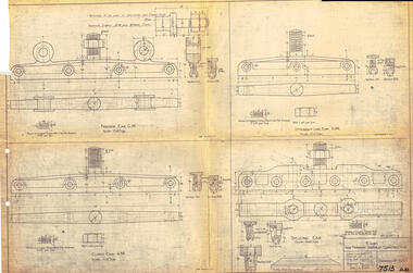
Drawing, Victorian Railways (VR), Ears for Tramway Overhead Construction, 1924
... Overhead Construction Drawing Melbourne Victorian Railways ...Gives the design details of the device or fitting known as a trolley wire ears that holds a tramway copper trolley wire in position. Notes that the drawing was traced in 1924 from a MMTB drawing. Has details for a splicing ear, straight line ear. feeder ear and curve ear along with details for nuts and screws.Yields information about the design of four different types of trolley wire fittings and how they were fabricated for use on the two tram lines, or electric street railways operated by the Victorian Railways.Dyeline print of Victorian Railways drawing number 4057 - Ears for Tramway Overhead ConstructionHas number "7513 D.33" in black pen in bottom right hand corner.tramways, trams, overhead, victorian railways, trolley wire, engineering, electrical engineering -
 Kew Historical Society Inc
Plan, Melbourne & Metropolitan Board of Works. Borough of Kew Detail Plan No.1579, 1904
The Melbourne and Metropolitan Board of Works (MMBW) plans were produced from the 1890s to the 1950s. They were crucial to the design and development of Melbourne's sewerage and drainage system. The plans, at a scale of 40 feet to 1 inch (1:480), provide a detailed historical record of Melbourne streetscapes and environmental features. Each plan covers one or two street blocks (roughly six streets), showing details of buildings, including garden layouts and ownership boundaries, and features such as laneways, drains, bridges, parks, municipal boundaries and other prominent landmarks as they existed at the time each plan was produced. (Source: State Library of Victoria). This plan forms part of a large group of MMBW plans and maps that was donated to the Society by the Mr Poulter, City Engineer of the City of Kew in 1989. Within this collection, thirty-five hand-coloured plans, backed with linen, are of statewide significance as they include annotations that provide details of construction materials used in buildings in the first decade of the 20th century as well as additional information about land ownership and usage. The copies in the Public Record Office Victoria and the State Library of Victoria are monochrome versions which do not denote building materials so that the maps in this collection are invaluable and unique tools for researchers and heritage consultants. A number of the plans are not held in the collection of the State Library of Victoria so they have the additional attribute of rarity.Original survey plan, issued by the MMBW to a contractor with responsibility for constructing sewers in the area identified on the plan within the Borough of Kew. The plan was at some stage hand-coloured, possibly by the contractor, but more likely by officers working in the Engineering Department of the Borough and later Town, then City of Kew. The hand-coloured sections of buildings on the plan were used to denote masonry or brick constructions (pink), weatherboard constructions (yellow), and public buildings (grey). While MMBW Plan No.1579 does not include many buildings, those that it does show are significant to Kew’s history. These include the ‘Kew [Railway] Station’ in Denmark Street and the ‘Recreation Hall’ and rear courts off Wellington Street. The plan shows the outline of the Recreation Hall, constructed in 1880, at the rear of which is listed a bowling green, two tennis courts, a ‘skittle alley’ and a pavilion. When the Hall was first built, the Kew Cricket Club occupied an adjacent ground, however in 1885 this was acquired by the State Government as the future location of the Kew Railway Station. The Plan also shows a single oval at Xavier College. This oval was completed in 1883. One of the current ovals conforms to this oval’s original shape and position in the school grounds.melbourne and metropolitan board of works, detail plans, maps - borough of kew, mmbw 1579, cartography -
 Kew Historical Society Inc
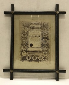
Certificate, Melbourne Tramways Trust, Framed Testimonial to Alderman Thomas O'Grady J.P. from the Melbourne Tramways Trust, 5 February 1886
The recipient of the testimonial, Thomas O’Grady (1824-90) had migrated to Melbourne in 1854, practising the trades of building and contracting. The Australian Dictionary of Biography records that he became a Councillor of the City of Melbourne in 1868. It lists one of his major achievements as the construction ‘with Leggett & Noonan [of] the fifty-six-mile (90 km) railway from Essendon to Seymour’. He was chairman of the Tramways Trust from its formation in 1884. His obituary in the Melbourne Herald (29 Apr 1890) reported: "DEATH OF ALDERMAN THOMAS O'GRADY. Today we have the sad duty of recording the death of two old colonists, who for many years, havo occupied very, prominent positions in building, commercial and municipal circles. The first of these is Alderman Thomas O'Grady, who died last night at his residence in Carlton. Mr O'Grady has been ill for some time, and at one period his death was expected any moment. Then he rallied, and strong hopes of his recovery were entertained; but he had a relapse, and expired as stated. The deceased gentleman was one of the oldest members of the City Council, in which he has held the various positions of Councillor, Alderman and Mayor. At the time of his death he sat as alderman for Victoria Ward. Mr O'Grady also at one time represented the City Council on the Harbor Trust, and was chairman of that body. He has been the council's representative on the Tramway Trust and was chairman of that body for some considerable time." As late as 1951, the Advocate (11 Oct 1951) stated that: "To Alderman Thomas O'Grady, Lord Mayor of Melbourne in 1872-3, is due the credit of the successful inauguration of Hospital Sunday. Alderman O'Grady was the first Catholic Lord Mayor of the city. He was elected a councillor for Smith Ward in 1868, and an alderman in 1869. In private life he was an extensive contractor, being a member of the firm of O'Grady, Leggett and Noonan, the contractors for the first section of the Northeastern Railways (between Melbourne and Seymour)."This is a unique civic document, illustrating the life and contribution of Thomas O’Grady (1824-90), Melbourne City Councillor and first Chairman of the Melbourne Tramways Trust. It is historically significant in its recording of the development of Melbourne's public transport system. The design of the certificate and particularly the ebonised frame are artistically and aesthetically significant.An illustrated testimonial presented to the first Chairman of the Melbourne Tramways Trust in 1886. The Testimonial is encased in an ebonized frame of the period. It includes the coat-of-arms of 12 cities, corporations, boroughs and towns, including that of Kew. At the head of the testimonial the engines used to drive the cable systems are illustrated. At the foot of the testimonial there is a picture of two cable trams.The testimonial reads: ‘At the meeting of the Melbourne Tramways Trust held on the Fifth Day of February 1886, the following resolution was unanimously carried. That the thanks of the Melbourne Tramways Trust are due and are hereby accorded to Alderman Thomas O’Grady Hon. JP, the first Chairman of the Trust for the ability, courtesy and impartiality with which he has discharged his duties during the past two years, and the Trust heartily congratulates him on the successful opening during his term of office of the Richmond Tramway (the first Cable line constructed in Australia) and tenders him its earnest wishes for his future prosperity and welfare.’ melbourne tramways trust, thomas o’grady (1824-90), cable trams, lord mayors of melbourne -
![Photographs [Series], Noel Kelly, Chandler Highway Bridge Construction, 11/07/2018](/media/collectors/550653872162f11fb04854aa/items/5c2f52bd21ea670d20783d9e/item-media/5c2f53b221ea670d2079233e/item-fit-380x285.jpg) Kew Historical Society Inc
Kew Historical Society IncPhotographs [Series], Noel Kelly, Chandler Highway Bridge Construction, 11/07/2018
A selection of photographs taken in July/August 2018 recording work on the old and new Chandler Highway Bridges.chandler highway bridge, noel kelly, railway viaduct - river yarra -
 Kew Historical Society Inc
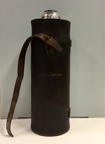
Container - Erica Lines Thermos Flask, 1900-1950
... construction of the railway line from Moe to Walhalla. When the station... construction of the railway line from Moe to Walhalla. When the station ...Erica is a town in Victoria, in the Shire of Baw Baw. In the early 1900s, the township of Erica began to grow after construction of the railway line from Moe to Walhalla. When the station opened in 1910 it was named Harris, but was renamed Erica in 1914. Erica was to become the largest town on the Moe-Walhalla railway. The railway line from Moe to Erica closed in 1954. When the item was donated by Raif Brunette in 2007 it was described as a 'Stagecoach thermos flask with leather protective cover'.Metal thermos flask encased in a leather cover embossed with the name 'Erica Lines'."ERICA LINES"erica lines, thermos flasks -
 Kew Historical Society Inc
Photograph, J F C Farquhar, Railway Bridge Over the Yarra, 1891
At the beginning of the 1890s, the Kew businessman and Town Councillor, Henry Kellett, commissioned J.F.C. Farquhar to photograph scenes of Kew. These scenes included panoramas as well as pastoral scenes. The resulting set of twelve photographs was assembled in an album, Kew Where We Live, from which customers could select images for purchase.The preamble to the album describes that the photographs used the ‘argentic bromide’ process, now more commonly known as the gelatine silver process. This form of dry plate photography allowed for the negatives to be kept for weeks before processing, hence its value in landscape photography. The resulting images were considered to be finely grained and everlasting. Evidence of the success of Henry Kellett’s venture can be seen today, in that some of the photographs are held in national collections.It is believed that the Kew Historical Society’s copy of the Kellett album is unique and that the photographs in the book were the first copies taken from the original plates. It is the first and most important series of images produced about Kew. The individual images have proved essential in identifying buildings and places of heritage value in the district.Completed in November 1890, the railway viaduct (now the Chandler Highway Bridge) linked Kew and Fairfield. The viaduct is significant as the most substantial extant engineering remnant of the Outer Circle Railway Line. Opened in March 1891, the viaduct crossed the Yarra River in a single span, atop three supporting brick pillars. Following the closure of the railway line in 1927, and the construction of the Chandler Highway in 1930, the bridge was used for vehicular traffic. In 1891 when this panoramic photograph was taken, the grounds of what was then the Kew Lunatic Asylum extended down to the River and eastward beyond the viaduct. The landscape surrounding the Asylum was planted with traditional exotic trees such as Oaks, Pines and Cedars, and landmark trees from northern Australia such as the Hoop Pine. Remnant indigenous trees such as the River Red Gum, Yellow Box and Lightwood were scattered around the site, including beside the Yarra River.Railway Bridge Over the Yarrakew illustrated, kew where we live, photographic books, henry kellett, railway viaduct - - kew (vic) -
 Kew Historical Society Inc
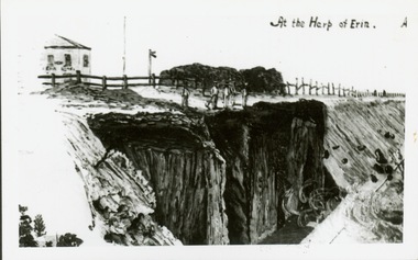
Print, At the Harp of Erin
Reproduction of newspaper drawing of earthworks near the Harp of Erin in Kew East during construction of the Outer Circle railway.Reverse: " Sketch of blasting near Harp of Erin Hotel, East Kew about 1889 -
 Kew Historical Society Inc
Photograph - Railway level crossing in Glenferrie Road, Glenferrie, E.J. Dower, 1912
Contextual or historic information One of a series of photographs, taken by Edgar James Dower in the second decade of the twentieth century. Born and raised in Olinda, his family later moved to Surrey Hills. He worked as an adult as a clerk in the city office of the Metropolitan Gas Company, and in his role as a 'collector', he was able to photograph scenes including the construction of tramlines and associated buildings in Kew, Hawthorn, Camberwell and Surrey Hills. Later he established a real estate agency with his brother - the E.J. Dower Real Estate Agency, Dandenong Office.The image is an historically significant record of the development of transport infrastructure which was used to connect Victorians in the first two decades of the twentieth century. This development resulted from increases in population and the consequent extension of Melbourne's suburbs. The photographs, both individually and collectively, richly detail the labour of workers and the tools and machinery used to create and extend Melbourne's tram network in the years preceding and during World War 1.Two faded original horizontal photographs, mounted on vertical card showing the original railway level crossing in Glenferrie Road, Hawthorn, before a railway overpass was constructed and the laying of the electric tramline. The two photos depict northern and southern views of the crossing. Dimensions: Photo 1 106 x 157 mm Photo 2 107 x 147 mm Mount 249 x 197 mmAnnotated recto: "Showing tramway gates at Glenferrie, taken 1912 by E.J. Dower, just prior to construction of electric tramline." Verso: "1912"theme --- travelling by tram, theme -- connecting victorians by transport and communications, trams -- boroondara (vic.), tramways -- hawthorn, trains -- hawthorn (vic.), glenferrie station -
 Kew Historical Society Inc
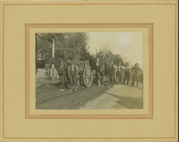
Photograph - Electric tram line construction in Cotham Road, Kew, E.J. Dower, 1913
One of a series of photographs, taken by Edgar James Dower in the second decade of the twentieth century. Born and raised in Olinda, his family later moved to Surrey Hills. He worked as an adult as a clerk in the city office of the Metropolitan Gas Company, and in his role as a 'collector', he was able to photograph scenes including the construction of tramlines and associated buildings in Kew, Hawthorn, Camberwell and Surrey Hills. Later he established a real estate agency with his brother - the E.J. Dower Real Estate Agency, Dandenong Office.The image is an historically significant record of the development of transport infrastructure which was used to connect Victorians in the first two decades of the twentieth century. This development resulted from increases in population and the consequent extension of Melbourne's suburbs. The photographs, both individually and collectively, richly detail the labour of workers and the tools and machinery used to create and extend Melbourne's tram network in the years preceding and during World War 1.Digital copy of an original mounted photograph depicting construction of a new electric tramline in Cotham Road, Kew. The photo shows a pair of horse drawn drays with workers posed beside them. An annotation on the reverse of the photo notes that the drays were used to transport the steel tram tracks from the Hawthorn Railway Station siding. Annotated verso: "1913 / Preparing for Electric Tram Cotham Road Kew / Metal [tracks] transported by horse and dray from Hawthorn Railway siding"theme --- travelling by tram, theme -- connecting victorians by transport and communications, cotham road -- kew (vic.), trams -- kew (vic.) -
![Workers, horses and drays in Burwood Road [Hawthorn]](/media/collectors/550653872162f11fb04854aa/items/661f4c86ac7f9cfd1fd6c658/item-media/661f4d6bac7f9cfd1fd722a1/item-fit-380x285.jpg) Kew Historical Society Inc
Kew Historical Society IncPhotograph - Workers, horses and drays in Burwood Road [Hawthorn], E.J. Dower, 1913
One of a series of photographs, taken by Edgar James Dower in the second decade of the twentieth century. Born and raised in Olinda, his family later moved to Surrey Hills. He worked as an adult as a clerk in the city office of the Metropolitan Gas Company, and in his role as a 'collector', he was able to photograph scenes including the construction of tramlines and associated buildings in Kew, Hawthorn, Camberwell and Surrey Hills. Later he established a real estate agency with his brother - the E.J. Dower Real Estate Agency, Dandenong Office.The image is an historically significant record of the development of transport infrastructure which was used to connect Victorians in the first two decades of the twentieth century. This development resulted from increases in population and the consequent extension of Melbourne's suburbs. The photographs, both individually and collectively, richly detail the labour of workers and the tools and machinery used to create and extend Melbourne's tram network in the years preceding and during World War 1.Digital copy of an original mounted photograph depicting construction workers, horses and drays Hawthorn. The intense activity involved collecting materials for transport to the construction site in Cotham Road, Kew. Annotated recto: "Unloading trucks of metal for Kew Electric Tram Line in Cotham Road / At Hawthorn Railway Siding" Annotated verso: "Taken by E.J.D. / 1913"theme --- travelling by tram, theme -- connecting victorians by transport and communications, cotham road -- kew (vic.), trams -- kew (vic.), hawthorn railway station -
 Kew Historical Society Inc
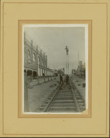
Photograph - Construction of the electric tram line in Glenferrie Road, Glenferrie, E.J. Dower, 1914
One of a series of photographs, taken by Edgar James Dower in the second decade of the twentieth century. Born and raised in Olinda, his family later moved to Surrey Hills. He worked as an adult as a clerk in the city office of the Metropolitan Gas Company, and in his role as a 'collector', he was able to photograph scenes including the construction of tramlines and associated buildings in Kew, Hawthorn, Camberwell and Surrey Hills. Later he established a real estate agency with his brother - the E.J. Dower Real Estate Agency, Dandenong Office.The image is an historically significant record of the development of transport infrastructure which was used to connect Victorians in the first two decades of the twentieth century. This development resulted from increases in population and the consequent extension of Melbourne's suburbs. The photographs, both individually and collectively, richly detail the labour of workers and the tools and machinery used to create and extend Melbourne's public transport network in the years preceding and during World War 1.Digital copy of an original mounted photograph showing a worker standing on a ladder in Glenferrie Road, Hawthorn, working on the overhead electric cables that would be used to power trams on the New Kew tramline.Other railway workers are working on platforms or viewing the man on the ladder. The ladder appears to be only supported by one other worker. "The Don Store" at left is immediately behind the old railway level crossing which can be seen in the distance to the south.Annotated verso: "Preparing for electric trams in Glenferrie Road, near Glenferrie Station, showing railway gates / Taken by E.J. Dower 1914"theme --- travelling by tram, theme -- connecting victorians by transport and communications, glenferrie road -- hawthorn (vic.), railways -- hawthorn -
 Kew Historical Society Inc
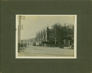
Photograph - Railway level crossing in Glenferrie Road, Glenferrie, E.J. Dower, 1912
One of a series of photographs, taken by Edgar James Dower in the second decade of the twentieth century. Born and raised in Olinda, his family later moved to Surrey Hills. He worked as an adult as a clerk in the city office of the Metropolitan Gas Company, and in his role as a 'collector', he was able to photograph scenes including the construction of tramlines and associated buildings in Kew, Hawthorn, Camberwell and Surrey Hills. Later he established a real estate agency with his brother - the E.J. Dower Real Estate Agency, Dandenong Office.The image is an historically significant record of the development of transport infrastructure which was used to connect Victorians in the first two decades of the twentieth century. This development resulted from increases in population and the consequent extension of Melbourne's suburbs. The photographs, both individually and collectively, richly detail the labour of workers and the tools and machinery used to create and extend Melbourne's public transport network in the years preceding and during World War 1.Digital copy of an original mounted photograph showing Glenferrie Road Hawthorn, looking north towards the old railway level crossing that existed before the line was elevated on a bridge over Glenferrie Road. "The Don Store" at right is immediately behind the old railway level crossing. The tree and shops at left before the crossing were to be removed / demolished as part of the realignment of the train tracks.Annotated verso: "Glenferrie Road, Glenferrie, showing railway gates and Walker's Store / Taken prior to the construction of electric tramline and the regrading of Camberwell Railway Line / Taken by E.J. Dower about 1912".theme --- travelling by tram, theme -- connecting victorians by transport and communications, glenferrie road -- hawthorn (vic.), railways -- hawthorn, the don store -- hawthorn (vic.) -
 Kew Historical Society Inc
Photograph - Camberwell Railway Station & Auburn Railway Station, E.J. Dower, 1915
... including the construction of tramlines, railways and associated... including the construction of tramlines, railways and associated ...One of a series of photographs, taken by Edgar James Dower in the second decade of the twentieth century. Born and raised in Olinda, his family later moved to Surrey Hills. He worked as an adult as a clerk in the city office of the Metropolitan Gas Company, and in his role as a 'collector', he was able to photograph scenes including the construction of tramlines, railways and associated buildings in Kew, Hawthorn, Camberwell and Surrey Hills. Later he established a real estate agency with his brother - the E.J. Dower Real Estate Agency, Dandenong Office.The image is an historically significant record of the development of transport infrastructure which was used to connect Victorians in the first two decades of the twentieth century. This development resulted from increases in population and the consequent extension of Melbourne's suburbs. The photographs, both individually and collectively, richly detail the labour of workers and the tools and machinery used to create and extend Melbourne's public transport network in the years preceding and during World War 1.Digital copy of a an original mounted photograph showing the Camberwell Railway station being demolished and the Auburn Railway Station. The photos were later dated by the photographer as being taken in 1915.verso: "2015 / Top picture - Original Camberwell railway station being demolished / Bottom picture - Original Auburn Railway station on left / Taken by E.J. Dower"theme -- connecting victorians by transport and communications, camberwell railway station, auburn railway station, theme - travelling by train -
 Kew Historical Society Inc
Photograph - Construction of the electric tram line in Riversdale Road, Camberwell
... including the construction of tramlines, railways and associated... including the construction of tramlines, railways and associated ...One of a series of photographs, taken by Edgar James Dower in the second decade of the twentieth century. Born and raised in Olinda, his family later moved to Surrey Hills. He worked as an adult as a clerk in the city office of the Metropolitan Gas Company, and in his role as a 'collector', he was able to photograph scenes including the construction of tramlines, railways and associated buildings in Kew, Hawthorn, Camberwell and Surrey Hills. Later he established a real estate agency with his brother - the E.J. Dower Real Estate Agency, Dandenong Office.The image is an historically significant record of the development of transport infrastructure which was used to connect Victorians in the first two decades of the twentieth century. This development resulted from increases in population and the consequent extension of Melbourne's suburbs. The photographs, both individually and collectively, richly detail the labour of workers and the tools and machinery used to create and extend Melbourne's public transport network in the years preceding and during World War 1.Digital copy of an original mounted photograph showing workers excavating Riversdale Road, Camberwell, in preparation for the laying of the new electric tramline.Verso: "Riversdale Road between Wattle Valley and Highfield Roads"theme -- connecting victorians by transport and communications, riversdale road - camberwell (vic.), theme -- travelling by tram -
 Kew Historical Society Inc
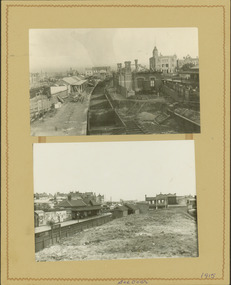
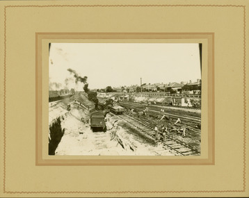
Photograph - Regrading the Camberwell Railway Line near Burke Road, E.J. Dower, 1915
... including the construction of tramlines, railways and associated... including the construction of tramlines, railways and associated ...One of a series of photographs, taken by Edgar James Dower in the second decade of the twentieth century. Born and raised in Olinda, his family later moved to Surrey Hills. He worked as an adult as a clerk in the city office of the Metropolitan Gas Company, and in his role as a 'collector', he was able to photograph scenes including the construction of tramlines, railways and associated buildings in Kew, Hawthorn, Camberwell and Surrey Hills. Later he established a real estate agency with his brother - the E.J. Dower Real Estate Agency, Dandenong Office.The image is an historically significant record of the development of transport infrastructure which was used to connect Victorians in the first two decades of the twentieth century. This development resulted from increases in population and the consequent extension of Melbourne's suburbs. The photographs, both individually and collectively, richly detail the labour of workers and the tools and machinery used to create and extend Melbourne's public transport network in the years preceding and during World War 1.Digital copy of an original mounted photograph depicting workers regrading the Camberwell Railway line following the demolition of the original Camberwell Railway Station. The level crossing gates at Burke Road can be seen in the distance. Named buildings include The Assembly Hall at right.Verso: "1915 / Regrading Camberwell Railway Line / Note Railway Gates on Burke Road / Taken by E.J. Dower"theme -- connecting victorians by transport and communications, theme - camberwell railway station, theme - travelling by train -
 Kew Historical Society Inc
Photograph - Regrading the Camberwell Railway Line, E.J. Dower, 1915
... including the construction of tramlines, railways and associated... including the construction of tramlines, railways and associated ...One of a series of photographs, taken by Edgar James Dower in the second decade of the twentieth century. Born and raised in Olinda, his family later moved to Surrey Hills. He worked as an adult as a clerk in the city office of the Metropolitan Gas Company, and in his role as a 'collector', he was able to photograph scenes including the construction of tramlines, railways and associated buildings in Kew, Hawthorn, Camberwell and Surrey Hills. Later he established a real estate agency with his brother - the E.J. Dower Real Estate Agency, Dandenong Office.The image is an historically significant record of the development of transport infrastructure which was used to connect Victorians in the first two decades of the twentieth century. This development resulted from increases in population and the consequent extension of Melbourne's suburbs. The photographs, both individually and collectively, richly detail the labour of workers and the tools and machinery used to create and extend Melbourne's public transport network in the years preceding and during World War 1.Digital copy of an original mounted photograph depicting workers regrading the Camberwell Railway line following the demolition of the original Camberwell Railway Station. The photographer noted the presence of a wheeled 'steam shovel' at left Verso: "1915 / Regrading Camberwell railway line taken just east of Camberwell Station / Note steam shovel at work / Taken by E.J.D."theme -- connecting victorians by transport and communications, theme - camberwell railway station, theme - travelling by train -
 Kew Historical Society Inc
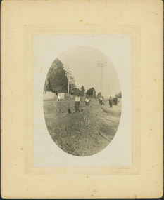
Photograph - Regrading the Camberwell Railway Line near Burke Road, E.J. Dower, 1915
... including the construction of tramlines, railways and associated... including the construction of tramlines, railways and associated ...One of a series of photographs, taken by Edgar James Dower in the second decade of the twentieth century. Born and raised in Olinda, his family later moved to Surrey Hills. He worked as an adult as a clerk in the city office of the Metropolitan Gas Company, and in his role as a 'collector', he was able to photograph scenes including the construction of tramlines, railways and associated buildings in Kew, Hawthorn, Camberwell and Surrey Hills. Later he established a real estate agency with his brother - the E.J. Dower Real Estate Agency, Dandenong Office.The image is an historically significant record of the development of transport infrastructure which was used to connect Victorians in the first two decades of the twentieth century. This development resulted from increases in population and the consequent extension of Melbourne's suburbs. The photographs, both individually and collectively, richly detail the labour of workers and the tools and machinery used to create and extend Melbourne's public transport network in the years preceding and during World War 1.Digital copy of an original oval mounted photograph depicting workers regrading the Camberwell Railway line in the vicinity of Burke Road following the demolition of the original Camberwell Railway Station. Verso: "1915 / Regrading Camberwell railway line, near Burke Road / Taken by E.J.Dower."theme -- connecting victorians by transport and communications, theme - camberwell railway station, theme - travelling by train -
 Kew Historical Society Inc
Photograph - Regrading the Camberwell Railway Line near Burke Road, E.J. Dower, 1915
... including the construction of tramlines, railways and associated... including the construction of tramlines, railways and associated ...One of a series of photographs, taken by Edgar James Dower in the second decade of the twentieth century. Born and raised in Olinda, his family later moved to Surrey Hills. He worked as an adult as a clerk in the city office of the Metropolitan Gas Company, and in his role as a 'collector', he was able to photograph scenes including the construction of tramlines, railways and associated buildings in Kew, Hawthorn, Camberwell and Surrey Hills. Later he established a real estate agency with his brother - the E.J. Dower Real Estate Agency, Dandenong Office.The image is an historically significant record of the development of transport infrastructure which was used to connect Victorians in the first two decades of the twentieth century. This development resulted from increases in population and the consequent extension of Melbourne's suburbs. The photographs, both individually and collectively, richly detail the labour of workers and the tools and machinery used to create and extend Melbourne's public transport network in the years preceding and during World War 1.Digital copy of an original oval mounted photograph depicting workers regrading the Camberwell Railway line following the demolition of the original Camberwell Railway Station. The level crossing gates at Burke Road can be seen in the distance. Named buildings include The Assembly Hall at right.Verso: "1915 / Regrading Camberwell railway line, near Burke Road / Taken by E.J.Dower."theme -- connecting victorians by transport and communications, theme - camberwell railway station, theme - travelling by train -
![Construction of the electric tram line in Cotham Road [Kew]](/media/collectors/550653872162f11fb04854aa/items/662870846214a76cee3aecf0/item-media/662870de6214a76cee3af7de/item-fit-380x285.jpg) Kew Historical Society Inc
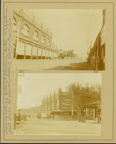
Kew Historical Society IncPhotograph - Construction of the electric tram line in Cotham Road [Kew], E.J. Dower, 1913
One of a small album of six photographs of the construction of the Cotham Road tramline in Kew, taken by Edgar James Dower in the second decade of the twentieth century. The reverse of each photo contains notes, written over time by the photographer, which are contained in the 'Inscriptions' field. Born and raised in Olinda, Dower's family later moved to Surrey Hills. He worked as an adult as a clerk in the city office of the Metropolitan Gas Company, and in his role as a 'collector', he was able to photograph scenes including the construction of tram and train lines and associated buildings in Kew, Hawthorn, Camberwell and Surrey Hills. Later he established a real estate agency with his brother - the E.J. Dower Real Estate Agency, Dandenong Office. The album as a whole can be viewed separately as the parent file.The image is an historically significant record of the development of transport infrastructure which was used to connect Victorians in the first two decades of the twentieth century. This development resulted from increases in population and the consequent extension of Melbourne's suburbs. The photographs in the album, as well as Dower's single photos mounted on card, individually and collectively richly detail the labour of workers and the tools and machinery used to create and extend Melbourne's tram and train networks in the years preceding and during World War 1.The first of six annotated photos in an album of photographs of the construction of the St Kilda to Kew electric tram line, taken in Cotham Road, Kew, by the amateur photographer, Edgar James Dower, in 1913. The album contains images detailing the preparation for the laying of the tracks plus work laying the line. The photographer notes on a number of the photos that te metal tracks were collected from the Hawthorn railway siding. The album, together with other phots by E.J. Dower has been made available by the owners for the Kew Historical Society to digitise and publish online and in print.Annotation verso: "1913 / Preparing for electric trams in Cotham Road Kew, looking west / Taken from corner of Burke Road by E.J. Dower / The metal was brought by horse and drays, from Hawthorn rail-way siding".keywords, theme -- connecting victorians by transport and communications, theme -- travelling by tram, photographers -- edgar james dower, cotham road -- kew (vic.) -
![Construction of the electric tram line in Cotham Road [Kew]](/media/collectors/550653872162f11fb04854aa/items/662879f26214a76cee3bcd7e/item-media/66287a4f6214a76cee3bd77d/item-fit-380x285.jpg) Kew Historical Society Inc
Kew Historical Society IncPhotograph - Construction of the electric tram line in Cotham Road [Kew], E.J. Dower, 1913
One of a small album of six photographs of the construction of the Cotham Road tramline in Kew, taken by Edgar James Dower in the second decade of the twentieth century. The reverse of each photo contains notes, written over time by the photographer, which are contained in the 'Inscriptions' field. Born and raised in Olinda, Dower's family later moved to Surrey Hills. He worked as an adult as a clerk in the city office of the Metropolitan Gas Company, and in his role as a 'collector', he was able to photograph scenes including the construction of tram and train lines and associated buildings in Kew, Hawthorn, Camberwell and Surrey Hills. Later he established a real estate agency with his brother - the E.J. Dower Real Estate Agency, Dandenong Office. The album as a whole can be viewed separately as the parent file.The image is an historically significant record of the development of transport infrastructure which was used to connect Victorians in the first two decades of the twentieth century. This development resulted from increases in population and the consequent extension of Melbourne's suburbs. The photographs in the album, as well as Dower's single photos mounted on card, individually and collectively richly detail the labour of workers and the tools and machinery used to create and extend Melbourne's tram and train networks in the years preceding and during World War 1.The second of six annotated photos in an album of photographs of the construction of the St Kilda to Kew electric tram line, taken in Cotham Road, Kew, by the amateur photographer, Edgar James Dower, in 1913. The album contains images detailing the preparation for the laying of the tracks plus work laying the line. The photographer notes on a number of the photos that the metal tracks were collected from the Hawthorn railway siding. The album, together with other phots by E.J. Dower has been made available by the owners for the Kew Historical Society to digitise and publish online and in print.Annotation verso: "Preparing electric tram Cotham Road, Kew, 1913 / The metal was brought by horses and drays, from Hawthorn railway siding".keywords, theme -- connecting victorians by transport and communications, theme -- travelling by tram, photographers -- edgar james dower, cotham road -- kew (vic.)