Showing 7053 items matching " station street"
-
 City of Ballarat Libraries
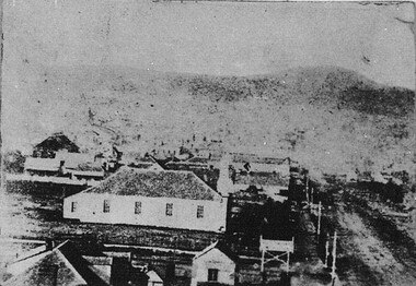
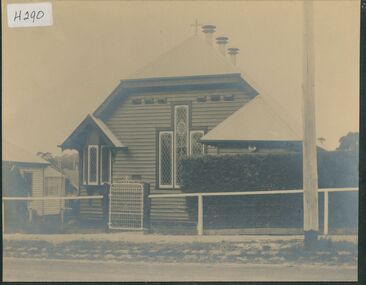
Photograph - Card Box Photographs, Second St Andrew's Kirk, Ballarat circa 1860
... City of Ballarat Libraries Eureka Centre Eureka Street ...Photograph taken from Ballarat City Fire Station tower. st andrew's kirk, ballarat city fire station, building, sturt street, church -
 Kew Historical Society Inc
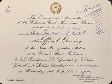
Document (item) - Invitation, Victorian Civil Ambulance Service, Official Opening of the New Headquarters Station, 1957
... new headquarters station - 64 latrobe street (melb)... STATION / AT 64 LATROBE STREET, MELBOURNE / BY HIS EXCELLENCY... headquarters station - 64 latrobe street (melb) THE PRESIDENT ...The Municipality of Kew (1860-1863), the Borough of Kew (1863-1910), the Town of Kew (1910-1921) and the City of Kew (1921-1994) were local government instrumentalities in the State of Victoria. In 1994, the City of Kew was amalgamated, together with the former Cities of Camberwell and Hawthorn, into the new City of Boroondara (1994- ). Like other local government entities of the period, Kew was administered by town clerks. The two notable town clerks in Kew's history were H. H. (Henry Hirst) Harrison (1868-1955) and W. D. (William Dickie) Birrell (1899-1974). Harrison was appointed to the position in 1901 and retired in 1938 after 37 years. Birrell, appointed Acting Town Clerk in 1921, became Town Clerk in 1938, following Harrison's retirement. He continued in this role until his retirement in 1966.This card is part of an historically significant civic collection, containing hundreds of separate invitations, documents, greeting cards, programmes and tickets issued and/or collected by successive town clerks. Items in the collection illuminate the political, social and cultural history of the district. As a continuous record, ranging across most decades of the Twentieth Century, they reveal changing tastes in design, values and relationships in the history of local government in Victoria.THE PRESIDENT AND COMMITTEE / OF THE VICTORIAN CIVIL AMBULANCE SERVICE / REQUEST THE PLEASURE OF THE COMPANY OF / The Town Clerk / AT THE OFFICIAL OPENING / OF THE NEW HEADQUARTERS STATION / AT 64 LATROBE STREET, MELBOURNE / BY HIS EXCELLENCY, THE GOVERNOR OF VICTORIA / GENERAL SIR DALLAS BROOKS KCB KCMG KCVO DSO KStJ / ON WEDNESDAY, 2ND JULY 1958 AT 3 P.M. / REFRESHMENTS / RSVP 20TH JUNE TO / THE SECRETARY VCAS 64 LATROBE STREET MELBOURNE C1civic invitations -- kew (vic), victorian civil ambulance service, new headquarters station - 64 latrobe street (melb) -
 Surrey Hills Historical Society Collection
Digital photo, George L Coop, Mont Albert Railway Station c 1956, c1956
... george lister coop, mont albert station, 1956, hamilton.... george lister coop, mont albert station, 1956, hamilton street ...The donor George Lister Coop was about 19 years of age when he took this photo. It is one of a small series of photos donated by him that relate to Mont Albert and Surrey Hills stations. He has always had an interest in railways and there are other examples of his documentation of railway history in other collections contributing to this database. This documents the original building on the northern platform of the Mont Albert station. The railway line was extended out to Lilydale with work commencing in 1882. It is not known exactly when the Mont Albert station was built, but it opened in 1890. It is presumed that this building was demolished when the third line was constructed in 1971. At this time the nearby Surrey Hills original station buildings were demolished.A black & white photo of Mont Albert station taken from the north platform adjacent to High Street, looking towards Box Hill. It clearly shows the bend in the line beyond the platforms. it also shows both the original buildings; the one on the north side having been demolished. There is a lady on the south platform adjacent to Hamilton Street. The roof line only of one of the Hamilton Road shops can be seen.george lister coop, mont albert station, 1956, hamilton street shops -
 Melbourne Tram Museum
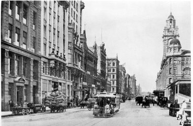
Photograph - Black and White - Flinders St looking east - 1915c
... Flinders Street station... Flinders Street Commerce House CTA Building Flinders Street station ...Photo of Flinders St looking east from about Queen Street, c1915. Has many horse drawn vehicles and one cable tram with two ladies riding on the front of the grip car. In the view are Robert Reid & Co, Commerce House, Finks building and Flinders St Station. The station was completed in 1909. Commerce House or the Commercial Travellers Association building was completed in 1913 - see reference.Yields information about Flinders Street between Queen and Elizabeth Streets.Photograph - Black and White - Flinders St looking east - 1915c from near Queen Street.tramways, trams, cable cars, flinders street, commerce house, cta building, flinders street station -
 Melbourne Tram Museum
Photograph - Black and White - St Kilda Road near City Road
... Flinders Street station... Street station St Kilda Road Princes Bridge Monuments Edmund ...Photo 1 - looking north from the point where St Kilda Road widened after crossing Princes Bridge. Has the Edmund Fitzgibbon monument on the left. One cable tram set is making its way into the City. Has Flinders St Station in the background, along with a number of motor cars and one horse drawn vehicle behind the monument and another behind a sign. In the far distance is an advertisement for The Herald newspaper. Photo 1910c Photo 2 - looking south from near the end of the bridge, with seven cable cars in the view, along with motors cars and two horse drawn vehicles. Government House can be seen on the left horizon.Yields information about St Kilda Road c1910.Set of two black and white photographs of" .1 - St Kilda Road near City Road looking north - with Edmund FitzGibbon monument .2 - looking southtramways, trams, cable cars, flinders street station, st kilda road, princes bridge, monuments, edmund fitzgibbon -
 Melbourne Tram Museum
Photograph - Flinders St station clocktower under construction, 1909
... Flinders Street station.... cable trams tramways Melbourne Flinders Street station ...Photo shows the Elizabeth St cable tram terminus with a grip car (destination of Royal Park), waiting for the trailer to pass before coupling up. The Elizabeth St clocktower is under construction - c1909. The station was completed in 1910.Yields information the Elizabeth St terminus and the Flinders St station construction.Photograph Flinders St station clocktower under construction with grip car reversingOn rear in ink. Melbourne – cable grip car standing in Elizabeth St at Shunt near Flinders St, city, destination shows Royal Park. Public Library of Victoria stamp – 16-9-1909 - Copy neg Mark Plummer collections ex late John Alfred collection. cable trams, tramways, melbourne, flinders street station, clocktower, elizabeth st -
 Merbein District Historical Society
Journal - Quarterly, Merbein Historian - Quarterly Journal of MDHS -No. 5 (2 copies), Sep.2001
... Station Cemetery - Merbein Street names - Merbein Cowanna Bend ...lew taylor, merbein higher elementary school - 1954, harold bennett, nanette griffin, nanette bennett, mr & mrs g. griffin, janice shillington, stan bennett, yelta railway, a.v. lyon, commonwealth research station, cemetery - merbein, street names - merbein, cowanna bend, george stewart, charlie dewilson, common, walter oakes, jock hogg, pop adams, dicky thomas, goodie family, noel goodie, old robbie - fisherman, tony fleetwood, bob cannon (presbyterian minister), keith ring, cliff ring, bob ring, mrs williams, lang children, william joseph caffrey, alex bruce, mollie smythe, barney o'connor, kate o'connor, charlie james, miss mahy, herbert chaffey, mrs delahoy, bill bennett, harry symons, harry bruce, hall buffalo, ern smythe, nancy swain, mrs mousdale, merbein bowling club, evelyn midgley, dr spargo, royal hall, clarrie martin, methodist church, rechabite lidge, mr beverly, mrs sheridan, merbein football club team 1965, sport, leisure, businesses, clive doering (trainer), ian gervasoni, kevin rule, brian williams (captain/coach), neil hurley, robert walder, kevin avery, ron bannister, noel barnes, neville mitchell, peter mitchell, frank fitzpatrick, jim stevens, kevin finteln, neville ward, kevin chapman, barry wagstaff (mascot), kevin sedgmen, barry walder, bill zonnenbergs, roxy café, merbein swimming pool, eva camin, railway - merbein, railway - yelta, railway - merbein west -
 Melbourne Tram Museum
Photograph - Tram 259 and Flinders St station, 1930s
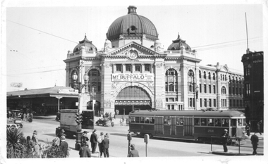
... Flinders Street station... tramways W2 class Swanston St Flinders Street station tram 259 Has ...Black and white photograph showing W2 class No. 259 northbound in Swanston St. The Flinders St Station building is in the background, which is advertising Mt Buffalo holidays. The intersection has been fitted with traffic lights. There are a MFB Fire alarm box and another alarm box in the foreground.Yields information about tram 359 and Swanston St, during the 1930s.Black and White photograph on Velox paper. Has a "Photo by Harringtons" stamp on the rear. and "No. 2 2/" in ink in top left hand corner.trams, tramways, w2 class, swanston st, flinders street station, tram 259 -
 Port Melbourne Historical & Preservation Society
Photograph - Nicholas Family, Port Melbourne, 1935 - 1964
... NICHOLAS Piers and Wharves - Station Pier Graham Street Bay Street ...Photographs as numbered: 1) Mary NICHOLAS on Port Melbourne beach holding Elizabeth NICHOLAS in 1935. 2) Edward &^ Elizabeth NICHOLAS with friend in backyard 89 Bay Street, port Melbourne. 3) Oriana about to depart Station Pier possibly November 1964. 4) August 1948 photograph taken in back yard of 89 Bay Street. L - R Back row: Allan & Mary NICHOLAS; Henry HAWKINS (Mary's stepfather). L - R Middle row: Edward, Elizabeth & Maxwell HAWKINS, Charlotte HAWKINS. Front row - unknown. 5) Elizabeth NICHOLAS in back yard 89 Bay Street. The ELMS family, the father was a grocer & his two sons, Ron & Norman, lived at number 87.. An A4 size page with five B&W photographs relating to the Nicholas family.Each photograph identified with a number 1 - 5.built environment - domestic, mary nicholas, elizabeth nicholas, transport - shipping, oriana, allan nicholas, henry hawkins, maxwell nicholas, charlotte hawkins (bennett), elms family, david thornton, edward nicholas, piers and wharves - station pier, graham street, bay street -
 Wangaratta Urban Fire Brigade
photograph - auxillary
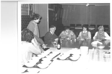
... dinner 1989 - 1991. At Ely street fire station' meeting room. L... a meal before a presentation dinner. At Ely street fire station... a presentation dinner 1989 - 1991. At Ely street fire station' meeting ...auxiliary members eating a meal before a presentation dinner 1989 - 1991. At Ely street fire station' meeting room. L- R unknown, Dorothy Wise, Joan Rosser, Sue Kayler Thompson, Lorraine Grenfell, Elaine Graham.Black and white photograph of auxiliary members eating a meal before a presentation dinner. At Ely street fire station' meeting room. 1989, auxillary, dorothy wise, joan rosser, sue kayler thompson, lorraine grenfell, elaine graham -
 Whitehorse Historical Society Inc.
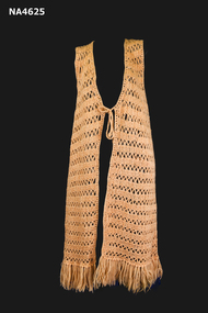
Clothing - Jacket - Crochet, 1970s
... );Wool bought at The Treasure House - a shop in Station Street... (Donor);Wool bought at The Treasure House - a shop in Station ...Crochet by Jean Gorsuch for daughter Judith Fry (Donor);Wool bought at The Treasure House - a shop in Station Street, Mitcham; shop later closed in the 1970s.Jacket. Orange crochet long sleeveless; 10cm fringe around hemline; two crochet ties at front.costume, female, handcrafts, crocheting or crochet work -
Tatura Irrigation & Wartime Camps Museum
Packing Slip Envelope, pre 1990
... spencer street railway station...Spencer Street Railway Station now known as Southern Cross.... Street Railway Station.... Tatura the-murray Spencer Street Railway Station now known ...Spencer Street Railway Station now known as Southern Cross.Regular size envelope, brown paper. Meant to hold packing slip. Has reinforced hole for tying to parcels. Wording indicates to be used at State Rivers and Water Supply Commission store yards at South Melbourne for Government carrier to Spencer Street Railway Station.To SRWSC Spencer St Railway Station per Government courier to SR & WSC store yard Brady Street South Melbourne. On rear are instructions to carrier.spencer street railway station, srwsc -
 Emerald Museum & Nobelius Heritage Park
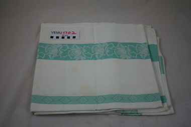
Cotton Tablecloth
... in Station Street, Emerald in the 1950's. And it was used in the home... was purchased at the Emerald Market held in Station Street, Emerald ...The Tablecloth was purchased at the Emerald Market held in Station Street, Emerald in the 1950's. And it was used in the home of Elaine and Doug Morris from the 1950's until 2016.Cotton (damask- like) tablecloth, white with green stripes'tablecloth -
 Chelsea & District Historical Society Inc
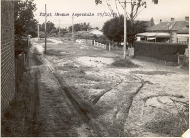
Photograph - First Avenue, Aspendale, 1949
... between Station Street and Sixth Avenue.... between Station Street and Sixth Avenue. unmade street Aspendale ...This photo is one of a collection of photos taken during Alan Niemann's - Drainage-Road Making Scheme. First Avenue runs between Station Street and Sixth Avenue.Black and white photo looking east along First Avenue, Aspendale. The road us unmade and rusted with vegetation growing on the road, houses and electricity poles line both sides. unmade street, aspendale, first avenue, alan niemann, drainage-road making scheme -
 Ringwood and District Historical Society
Plan, Ringwood Station Estate, Subdivision, Ringwood, Victoria - circa 1925
... includes Station Street, Pitt Street, Bedford Road, Wantirna Road... 988 Central. Subdivision includes Station Street, Pitt Street ...ID 5224 note: Further information relating to squares marked H, F, G, J, and K included in ID 5225 - Ringwood Shop and Dwelling Estate.Hand drawn plan of Ringwood Station Estate showing allotments for sale, with two typed pages attached showing land title information and sale prices.Drawn by Edyth Greenwood, phone 988 Central. Subdivision includes Station Street, Pitt Street, Bedford Road, Wantirna Road, James Street, William Street (later Kendall Street), Greenwood Avenue, Ellison Street, and Haig Street. Circles denote blocks for sale. Squares denote house properties for sale. Other features marked include location of businesses along Main Street (Maroondah Highway), cool store, railway station, shop and police station on Bedford Road, church on Station Street, site of schoolmaster's residence and State School, and location of proposed public baths. Ryner & Langford, Solicitors -
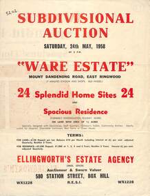 Ringwood and District Historical Society
Flyer, Subdivisional Auction Sale Brochure, Ware Estate, East Ringwood, Vic. - 1958
... , Davey Drive, and Grey Road (later Grey Street). Timber... Home. (Agent) Ellingworth's Estate Agency, 580 Station Street ...Folded double-sided advertisement for auction of 24 home sites and existing residence on Saturday, 24th May, 1958, including locality map, subdivision layout, terms of sale, and summary of local facilities and services. Additional plan of lots 28-33 dated 26/10/60 by Licensed Surveyor for Kirkpatrick & Webber, 225 Maroondah Highway Ringwood headed Plan of Subdivision of part of Crown Allotment 26A Parish of Ringwood.Subdivision includes Mount Dandenong Road, Ware Crescent, Davey Drive, and Grey Road (later Grey Street). Timber residence included in the subdivision was formerly Ware Kindergarten Holiday Home. (Agent) Ellingworth's Estate Agency, 580 Station Street, Box Hill - (Phone) WX1228. -
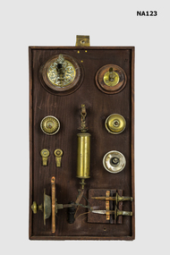 Whitehorse Historical Society Inc.
Equipment - Switches, 1900s
... , the last block of land on the east side of Station Street, now..., the last block of land on the east side of Station Street, now ...Fittings out of the Mitcham Station Master's house, the last block of land on the east side of Station Street, now a car park. Railway Department house number 1273 brass and ceramic light switches. 2 brass picture hooks. 1 brass and lead counterweight for lamp. 2 gas jets on wooden base. 1 door bell pull. 2 brass curtain holders. All on wooden base.metalcraft, brassware -
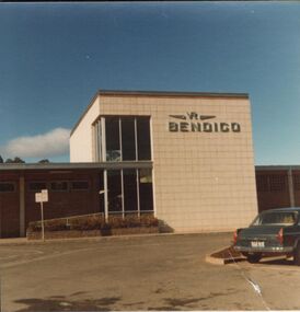 Bendigo Historical Society Inc.
Photograph - GREATER BENDIGO PHOTO COLLECTION: RAILWAY STATION, 1960-1970's
... Photograph. Bendigo Railway station off Mitchell Street... Railway station off Mitchell Street. Late 1960s early 1970s ...Photograph. Bendigo Railway station off Mitchell Street. Late 1960s early 1970s.bendigo, buildings, bendigo train station -
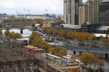 Ballarat Heritage Services
Digital Photograph, L.J. Gervasoni, MCG from Flinders St, c2015
... ) from Flinders Street Station, Melbourne. ... Ground (MCG) from Flinders Street Station, Melbourne. MCG from ...Colour photograph of the Melbourne Cricket Ground (MCG) from Flinders Street Station, Melbourne. mcg, melbourne cricket ground, flinders street, yarra river, melbourne -
 Bendigo Historical Society Inc.
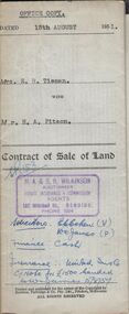
Document - H.A. & S.R. WILKINSON COLLECTION: CONTRACT OF SALE
... in certificate of title volume 4173 folio 834590 situate No. 47 Station... 4173 folio 834590 situate No. 47 Station Street, Bendigo ...Contract of sale of land dated 15th August, 1951 between Mrs. E.R. Tieman (seller) and Mr. H.A. Pitson (buyer) for land being part of Crown allotment 6 section 71C described in certificate of title volume 4173 folio 834590 situate No. 47 Station Street, Bendigo, together with 4-roomed weatherboard dwelling and all sundry. Price 1,720 pounds.organization, business, h.a. & s.r wilkinson real estate -
 Uniting Church Archives - Synod of Victoria
Photograph, Ringwood Presbyterian Church, c.1980
... The former Scots Presbyterian Church in Adelaide Street... moved to the Uniting Church in Station Street, Ringwood ...The former Scots Presbyterian Church in Adelaide Street Ringwood was demolished c.1980 to make way for the Eastland carpark. The Pulpit and windows were moved to the Uniting Church in Station Street, Ringwood.Colour photograph of the exterior of the Ringwood Uniting (formerly Scots Presbyterian) Church, located in Adelaide St. Ringwood. The manse can be seen next door to the church.ringwood, presbyterian, uniting, eastland -
 Uniting Church Archives - Synod of Victoria
Photograph, Ringwood Presbyterian Church, c.1920s
... The former Scots Presbyterian Church in Adelaide Street... moved to the Uniting Church in Station Street, Ringwood ...The former Scots Presbyterian Church in Adelaide Street Ringwood was demolished c.1980 to make way for the Eastland carpark. The Pulpit and windows were moved to the Uniting Church in Station Street, Ringwood.Sepia photograph of the exterior of the Scots Presbyterian Church, located in Adelaide St. Ringwood. ringwood, presbyterian, uniting, eastland -
 Whitehorse Historical Society Inc.
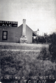
Photograph, Hill Hotel, Mitcham
... was situated on the south-west corner of Station Street and Whitehorse... was situated on the south-west corner of Station Street and Whitehorse ...The Hill Hotel was one of 3 hotels in Mitcham in the 1890's.The licensee was Mrs Bridget O'Callaghan. The hotel was situated on the south-west corner of Station Street and Whitehorse Road. It was delicensed in 1919Black and white photograph of the Hill Hotel, Mitcham, after it had closed in 1919. Graffiti on chimney.|See also NP1329. Alternative name - O'Callaghan's Hotelhill hotel, o'callaghan's hotel, hotels -
 Ringwood and District Historical Society
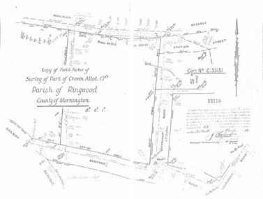
Document - Copy of Lands Department Field Notes - Parish of Ringwood, Victoria, Field Notes - Part of Crown Allotment 17D Surveyed 1952 (Amended in 1953)
... Reserve, Station Street, Bedford Road, multiple post & wire fences... include Corr no. C.93151, Railway Reserve, Station Street, Bedford ...5616b Double foolscap size photocopy of survey map with handwritten notations. References include Corr no. C.93151, Railway Reserve, Station Street, Bedford Road, multiple post & wire fences, multiple galv iron pipes put in, Government Road (Hill Street), Tooronga Road, multiple recent pegs found, Certification 52710 by J. Fitzgerald Licensed Surveyor 17/3/1952. -
 Wodonga & District Historical Society Inc
Functional object - Keys - Wodonga Police Station
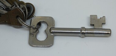
... Police Station in Elgin Street which opened in 1966. They were...A bunch of assorted keys from the Police Station in Elgin... from the Police Station in Elgin Street, Wodonga. They include ...These keys were used to ensure security at the Wodonga Police Station in Elgin Street which opened in 1966. They were used for approximately 40 years at this police station which moved to a new location in Hovell Street, Wodonga in 2002. They may have originated from the earlier police which was located in High Street, Wodonga and opened in the 1870s. The keys were created by J. Hubball, a locksmith based at 474 Little Lonsdale Street, Melbourne. He was also known as Joseph or Josh Hubball. He operated from these premises from the early 1920s until at least the 1940s. He gained a contract to provide locks and keys for many prisons throughout Australia, including Pentridge Gaol in Melbourne, Victoria and Caboolture Police Station in Queensland. His company also created keys used at Mayday Hills in Beechworth, Victoria. On 28th of March 1947, Hubball applied for a certificate of Incorporation of a Company in his name. The Directors of this company were William Hubball & Alfred Hubball.This key comes from the Police Station in Wodonga and was used for at least 40 years to secure the premises. It was created by a well-known Melbourne locksmith.A bunch of assorted keys from the Police Station in Elgin Street, Wodonga. They include keys for the main cell door as well as the exercise yard and gate room.On largest key 'Hubball" and on the reverse "Melbourne"wodonga police, wodonga police station -
 Sunbury Family History and Heritage Society Inc.
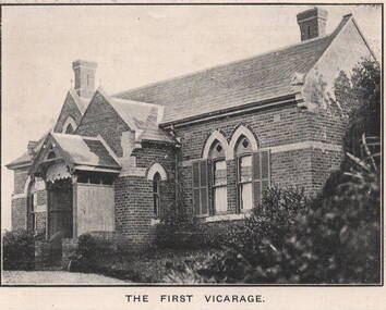
Photograph, 'Priorswood' Vicarage
... of Station Street on Vicarage Hill and about a kilometre from St... of Station Street on Vicarage Hill and about a kilometre from St ...The grand home is the first Church of England vicarage, 'Priorswood' to be built in Sunbury. It was sited at the east end of Station Street on Vicarage Hill and about a kilometre from St. Mary's Church in O'Shanassy Street. The distance between the two buildings presented a problem especially when the vicar had to negotiate a natural waterway across the lower end of Station Street after heavy rain. In 1914 a new Federation style vicarage was built adjacent to the church in O'Shanassy Street and was replaced in the 1960s with a more modern building, which was demolished in the 2020s to make way for 8 Oaks Community Centre.'Priorswood' is now a private home and has a local heritage listing.A print of a non-digital black and white photograph of a Gothic style brick home with a slate roof.'priorswood' vicarage, st. mary's church of england., sunbury, vicarages -
 Sunbury Family History and Heritage Society Inc.
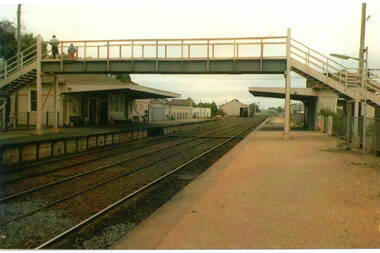
Photograph, c
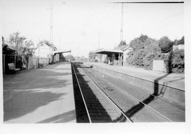
... crossing at Station Street and the storage sheds which were along... crossing at Station Street and the storage sheds which were along ...The photograph shows a view of Sunbury Railway station as it was in the 1970s and earlier. he image is looking south to the railway crossing at Station Street and the storage sheds which were along Platform 1, where the trains for Melbourne left.A coloured photograph of a railway station and pedestrian bridge.sunbury -
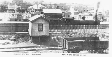 Ringwood and District Historical Society
Photograph, Maroondah Highway Central, Ringwood. Railway Station, Ringwood- c1920
... station looking north from Station Street. c1920." Inscription... station looking north from Station Street. c1920." Inscription ...Photograph (3 copies- 2 large, 1 small postcard)Typed below large photograph: "Overlooking Ringwood railway station looking north from Station Street. c1920." Inscription beneath photograph reads, "Railway Station. Ringwood. Real Photo Series M. 2451". Image shows steam locomotive in station, with platform advertising boards, and shops fronting Maroondah Highway. -
 Whitehorse Historical Society Inc.
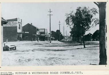
Photograph, Whitehorse Road, Mitcham, C1925
... way down the block between Mitcham Road and Station Street... between Mitcham Road and Station Street. Horse trough later moved ...Black and white photo of Whitehorse Road, Mitcham looking west -1925. Note the Mitcham Hardware Store (Ironmongery), the Post Office and Drake & Co. Section shown is further west than actual corner. Monty Gray's ironmongery was approximately half way down the block between Mitcham Road and Station Street. Horse trough later moved to front of Reserve Hotel. Drake and Co. shown on one of their several locations.whitehorse road, mitcham, mitcham post office, drake & co, mitcham hardware store, ironmongery -
 Hume City Civic Collection
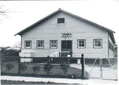
Photograph
... in Barkly Street between Brook and Stations Streets in the late... in Barkly Street between Brook and Stations Streets in the late ...The Yakka Company established a factory in Sunbury in Barkly Street between Brook and Stations Streets in the late 1950s. The Sunbury factory provided employment for the town's population which was increasing. It was established in Sunbury before the larger factory was built in Broadmeadows.A black and white photocopy of a photograph of the corrugated iron Yakka factory. The double doorway at the top of the ramp is flanked by 3 casement windows on one side and two on the other. There is a cyclone wire fence and gates across the front.yakka, corrugated iron, businesses, fences, barkly street, sunbury, george evans collection