Showing 4045 items
matching survey
-
 Whitehorse Historical Society Inc.
Document, Department of Crown Lands and Survey, 1983
Research guide of historical resources of the Department of Crown Lands and Survey. Compiled by P. Cabena, Aug 1983Research guide of historical resources of the Department of Crown Lands and Survey. Compiled by P. Cabena, Aug 1983Research guide of historical resources of the Department of Crown Lands and Survey. Compiled by P. Cabena, Aug 1983crown land, land surveys, victorian government -
 Peterborough History Group
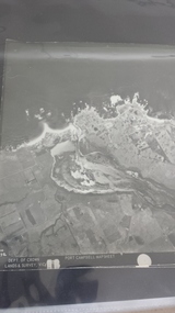
Photograph - Aerial Photograph Peterborough, Department of Crown Lands & Survey, Jan 1971
Aerial photograph showing the past layout of the townSignificant in that it shows the town as it was in 1971.Square 9" x 9" aerial photograph x 4 - (2 photos in duplicate)Stamped Dept of Crown Lands & Surveypeterborough 3270, curdies estuary, bay of islands, crown land photograph, aerial photograph, department of crown lands -
 Rutherglen Historical Society
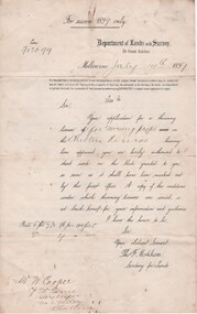
Document - License to thin trees, 1899 (Exact)
Dated July 14th 1899. Sent to Mr W. Cooper / c/o Mr Barrie / Storekeeper / No. 2 Valley / Chiltern / "Copy of Land Act 1896 / Regulations. Chapter XI Thinning Licenses"Document on stiff paper. Letter to Mr W. Cooper granting license to thin trees on a block of land at Chiltern Reserve. On back, copy of Land Act Regulations 1890"Department of Lands and Survey. On Forest Business"license, timber felling, cooper family, forestry, chiltern reserve -
 Ringwood and District Historical Society
Article - Newspaper Clipping, Land Sale Advertisements, Golden Hill Estate, Ringwood - 1965, 1966, and Plan of Survey of Lot 8, Mullum Mullum Road Ringwood, 1970
Newspaper clippings from Melbourne Sun newspaper (11th December 1965 and 15th January 1966) advertising sale of land - Golden Hill Estate, Ringwood, with summary of features and aerial photograph including artistic representation of street layout. Subdivision includes Mullum Mullum Road, Sonia Street, Jill Court, Linda Drive, Eve Court, Alma Court, and Jacynthe Court. Attachments include reference to Lot 46 as site of original Peter Vergers' orchard residence and subsequent 1970 surveyor's Plan of Survey of Lot 8 Mullum Mullum Road Ringwood, LP 67513, Cert of Title 8581/429.Agent - Aaron, King & Co., Suite 2, 33 Queens Road, Melbourne. (Phone) 26-2443, A.H. 850-2195. Plan of Survey signed on 25.7.1970 by Roger M. Gamble, Land Surveyor, 28 Summit Crescent, Ringwood 3134. -
Whitehorse Historical Society Inc.
Article, Local survey leads the way
Article covering a survey of Nunawading residents aged 70 and over.Article covering a survey of Nunawading residents aged 70 and over will help develop and improve services for the aged. With photo.Article covering a survey of Nunawading residents aged 70 and over. welfare services, quality of life project, haynes, howard, phillips, philippa, britton, di, aged people -
 Ringwood and District Historical Society
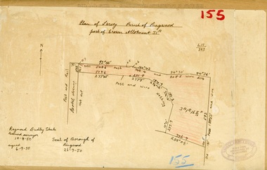
Map, Plan of Survey, Parish of Ringwood - Part of Crown Allotment 31A - 1950
Hand drawn and labelled copy of map with survey measurements of allotment on Isobel Avenue (Isabel Avenue?), Ringwood East. Raymond Dudley Steele Licensed Surveyor 10-8-50, signed 6-9-50, Seal of Borough of Ringwood 26-9-50. Rubber stamp - Dugdale, Simmons & Stevens, Solicitors, Peacock House, 486 Bourke Street Melbourne. Typewritten heading on backing paper - Capt. M.H. Moyes - Correspondence Supplementary to Statements. -
Lakes Entrance Historical Society
Book, Andrew Claridge, Survey of Crown Lands, 1989
A Preliminary Survey of Crown Lands between Lake Bunga and Mill Piont, Lake Tyers Beach Area Victoria.surveying -
 Bendigo Military Museum
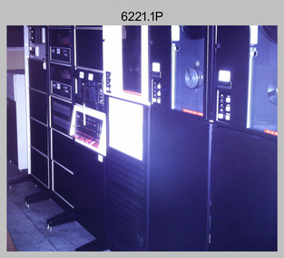
Photograph - Aerotriangulation Production – Army Survey Regiment, Fortuna, Bendigo, c1970s to 1980s
This collection of 14 photos was most likely taken in the 1970s and 1980s in Air Survey Squadron. The PDP 11/70 minicomputer shown in photo .1P was the operating system introduced in 1977 as the mainframe system for the control of the APC4, aerial triangulation block adjustments, SORA OP Analytical Orthophoto control, APR Analytical Terrain Profile Recorder computation, graphics, and general computing. Technicians used the Wild A9 Stereocomparator shown in photo .2P to accurately measure between pass, tie, and survey control points on aerial photographs. The Zeiss D2 Planimat Stereoplotter shown in photos .3P to .4P was used for analytical orthophoto control. It was introduced in 1972-1973 The Zeiss (Jena) Stecometer analytic stereocomparator for air photography shown in photos .5P to .11P and .14P was introduced at Air Survey Squadron in 1963. Aerotriangulation production was expedited using computers for analytical photogrammetric processes. The technician accurately measured between pass, tie, and survey control points on aerial photographs. Wild PUG4 point transfer devices shown in photos .12P to .13P were introduced in c1968 superseding the PUG2 devices. PUG4 devices were used by technicians to stereoscopically view the photography containing the survey control points and the mapping aerial photography. The Control points were transferred from the control photography to the mapping diapositives of aerial photography by drilling their locations into the photographic emulsion.This is a set of 14 photographs of Air Survey Squadron personnel operating aerotriangulation equipment at the Army Survey Regiment at Fortuna, Bendigo, c1970s to 1980s. Photographs .1P to .13P were on 35mm colour slide film and scanned at 96 dpi. Photograph.14P was printed on photographic paper and was scanned at 300 dpi. They are part of the Army Survey Regiment’s Collection. .1) - Photo, colour, c1979, PDP-11 minicomputer. .2) - Photo, colour, c1970s, Unidentified technician operating a Wild A9 Stereocomparator. .3) - Photo, colour, c1970s, Zeiss D2 Planimat Stereoplotter. .4) - Photo, colour, c1970s, Zeiss D2 Planimat Stereoplotter, unidentified technicians. .5) - Photo, colour, c1970s, Zeiss D2 Planimat Stereoplotter, SGT Christopher Wardley. .6) - Photo, colour, c1970s, Zeiss D2 Planimat Stereoplotter. .7) to.9) - Photo, colour, c1970, Zeiss (Jena) Stecometer, unidentified technicians. .10) to.11) - Photo, colour, c1988, SPR Toni Wright operating a Zeiss (Jena) Stecometer. .12) - Photo, colour, c1970s, Wild PUG4 point transfer device, SPR John Shepard. .13) - Photo, colour, c1970s, Wild PUG4 point transfer device, SPR David Edwards. .13) - Photo, colour, c1970s, Wild PUG4 point transfer device, SPR David Edwards. .14) - Photo, colour, c1980, Zeiss (Jena) Stecometer, SGT Bruce Hammond.Some of the equipment is annotated on the frame of the 35mm slides.royal australian survey corps, rasvy, army survey regiment, army svy regt, fortuna, asr, aerotrig, photogrammetry -
 Federation University Historical Collection
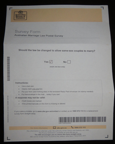
Document, Australian Marriage Law Survey, 2017, 12/09/2017
The vote was made online, so the paper vote papers were kept and donated. Letter from Australian Statistician David W. Kalisch regarding the Australian Marriage Survey, and a photograph of the ballot paper and envelope.australian marriage law, marriage equality, australian bureau of statistics, gay marriage, same sex marriage -
Whitehorse Historical Society Inc.
Document, Heritage survey, 1/10/1994 12:00:00 AM
City of Nunawading Heritage Survey Project [Description]. Context Pty Ltd [Consultants] October 1994.City of Nunawading Heritage Survey Project [Description]. Context Pty Ltd [Consultants] October 1994. (Original and 2 photocopies)City of Nunawading Heritage Survey Project [Description]. Context Pty Ltd [Consultants] October 1994. city of nunawading, historic buildings, context pty ltd -
 Bendigo Military Museum
Letter - Mapping correspondence about Papua New Guinea 1970-77, Dept of Natural Resources, Army Survey Regiment, Director of Survey - Army, 1 May 1970 - 8 Aug 1977
20 x Letters, Signals and Documents pertaining to Papua New Guinea (PNG) Mapping during the period 1970-77. These documents were important authoritative documents affecting the production of PNG mapping being produced at the Army Survey Regiment at that time.Foolscap size folder containing 20 x letters/signals pertaining to Papua New Guinea mapping. Several documents both have been numbered #15.Each letter/Signal is numbered 1-20. Document 1- has "recieved" stamp, Document 2- has a note and signature MM Knight WO2, Document 3 - has 788-2-18 ad "Recieved" , Document 5 - has "Sergeant RN Sargeant" annotated, Document -11 has two file numbers and "received" stamp, Document -12 (telephone record) has recipients stamp, date and initials and file ' R750-5-1, Document -13 "received" stamp and initials, Document -15 has "received" stamp and a note "apply after TALASEA", Document -16 includes a diagram, Document -17 "Distribution List" hand written, Document -18 "received" stamp, Document 19 has note and initials, Document -20 "recipients" stamp, note and initials and "Army Survey Regiment" document stamp. royal australian survey corps, rasvy, fortuna, army survey regiment, army svy regt, asr -
 Bendigo Military Museum
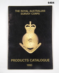
Booklet - PRODUCTS CATALOGUE 1993, RASvy Corps, Royal Australian Survey Corps. Products Catalogue1993, 1993
This Catalogue contains details on the products and capabilities available from the RASvy CorpsA4 Booklet black cover, Survey Corps badge in Gold. Sample maps of all products produced by RASvy Corps 1993rasvy, fortuna -
Kew Historical Society Inc
Archive (Sub-series) - Subject File, Kew Historical Society, HODDLE Survey, 1997
Various partiesReference, Research, InformationSecondary Values (KHS Imposed Order)Photocopied correspondence and maps (surveys) relating to surveys ordered by Robert Hoddle, Government Surveyor. Authors of letters and information include Gwen McWilliam and Jack Hackett. Much of the correspondence relates to the site of the ‘Hoddle Tree’, currently located in the Kew Golf Course. Jack Hackett’s original map is contained in the map drawers in the Society’s archive.kew historical society - archives, kew (vic) - history, robert hoddle - surveyor, hoddle tree - kew (vic), jack hackettkew historical society - archives, kew (vic) - history, robert hoddle - surveyor, hoddle tree - kew (vic), jack hackett -
 Bendigo Military Museum
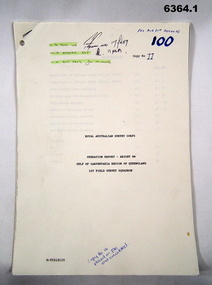
Administrative record - Royal Australian Survey Corps Report on Operation Aright 88 conducted by 1 Field Survey Squadron 1988, 1 Fd Svy Sqn, 9 Feb 1989
Comprehensive Operation Report containing all aspects of OP Aright 88 in the Gulf of Carpentaria region of Queensland. Chapters include: General Information, Operations, Operational Support, Admin and Logistics, Communications, Conclusion and Recommendations. There are four Annexes, Area of Operations, Technical Summary, Nominal Roll, Det 1 Fd Svy Sqn and Air Support Contact Details.Unbound A4 Paper Report held together by a staple top LH corner. Typed pages and diagrams. 6364.1 is copy number 11, 6364.2 is copy number 12 6364.1 is copy number 11, "FOR AIR SURVEY RECORDS" "Tech WO", "Aero Trig", "ADJ", "SGT REES for Records" 6364.2 is copy number 12 "Placed on File and circulated", "Circular Received 15 Feb 1989" on back page. royal australian survey corps, rasvy, fortuna, army survey regiment, army svy regt, asr -
 Anglesea and District Historical Society
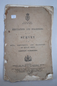
Steam Ship Regulations, Darling & Son Ltd, Regulations and Suggestions as to the Survey, 1905
Book of regulations and suggestions as to the survey of hull, equipments and machinery of steam ships carrying passengers. Dated 1905 which supersedes ed. 1901.ISSUED BY THE BOARD OF TRADE / REGULATIONS AND SUGGESTIONS OF THE HULL, EQUIPMENTS, AND MACHINERY OF STEAM SHIPS CARRYING PASSENGERS / LONDON / PRINTED FOR HIS MAJESTY'S STATIONERY OFFICE BY DARLING & SON LTD 34-40 BACON STREET E / 1905steam ships, regulations -
Stawell Historical Society Inc
Map, Underground Survey of the Principal Mines of Stawell 1879, 1879
Pleasant Creek & Newington, Prince Patrick, Prince Alfred, Pioneer and Galatea, Pleasant Creek Cross Reef No. 1&2, Magdala, Old Shaft, Extended Cross Reef, Crown Cross, Great Northern, Sloanes & Scotchmans, South Cross, 10 & 11 United Scotchmans South Cross, Scotchmans Shafts, North Scothmans, West Scotchmans, Emerald Isle & Rose of Denmark, Albion, South Scotchmans, Newington & Pleasant Creek, Pleasant Creek Cross Reef, Moonlight, Extended Cross Reef, Crown cross United, Great Northern ShaftVery large Map on cloth backing, showing cross sections of mines.Surveyed by H.C. Bates. Drawn by Arthur Edwards. October 30th 1879. Scales 120 feet to an inchmining, gold -
 Victorian Aboriginal Corporation for Languages
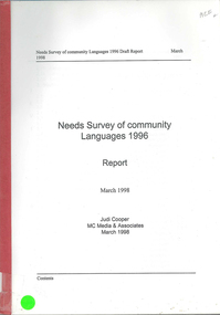
Book, Judi Cooper, Needs survey of community languages 1996 : report : March 1998, 1998
Report of Needs Survey of Community Languages, including, Methodology, Victoria, NSW, Queensland, Torres Strait Islanders, Western Australia, Northern Territory and summary. -
Whitehorse Historical Society Inc.
Map, Survey for road from Doncaster to Ringwood, 01/03/1867
Survey in County of Bourke, Road Plan no. 390, showing early routes of Doncaster, Whitehorse and Mitcham Roads.Survey in County of Bourke, Road Plan no. 390, showing early routes of Doncaster, Whitehorse and Mitcham Roads. Measurement in chains. Surveyor: Thomas E. Rawlinson.Survey in County of Bourke, Road Plan no. 390, showing early routes of Doncaster, Whitehorse and Mitcham Roads. parish of nunawading, parish of bulleen, whitehorse road mitcham, doncaster road, doncaster east, mitcham road mitcham -
 Federation University Historical Collection
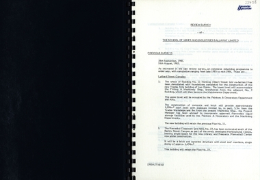
Report, SMB: Review Survey of Buildings and Grounds, July 1985, 1985
Report of the detailed review of The School of Mines and Industries Ballarat Limited undertaken by Alexander & Alexander in 1985. Previous reports were done in 1982 and 1983. The report covers all areas of the school - buildings and grounds. Some sections/buildings are still being completed. Report contains written evaluation, maps/diagrams and photographs.Spiral bound book - dark blue cover. 15 pages of written information plus 3 pages of photographs.Gold lettering on from cover "Alexander & Alexander" Signature "J W Elliott" on page 10 (Loss Control Surveyorballarat school of mines and industries, survey, alexander and alexander, j w elliott, maps, photographs -
 The 5th/6th Battalion Royal Victoria Regiment Historical Collection
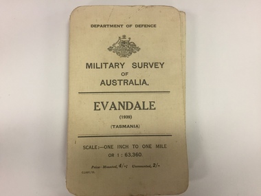
Map, Military Survey of Australia. Evandale (1939) (Tasmania), 1939
Fabric backed colour map, with card cover that folds into a small book. Scale one inch= one mile.military, survey, map, tasmania, ww2, wark vc club -
University of Melbourne, Burnley Campus Archives
Plan, Glenferrie PR. S. No. 1508: Detail Survey, 1982
Original and 2 copies of Public Works Department, Victoria plans of Glenferrie Primary School for the Department of Education SU 2241.2. Shows site plan of area bounded by Manningtree Road and Wattle Road. Pit Schedule of storm water and sewer pits.glenferre primary school, survey, victoria public works department, storm water, trees, p. manley (draftsman) -
 Linton and District Historical Society Inc
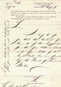
Letter, Paper manufactured by T. Edmonds 1890 (watermark), Department of Lands and Survey, Argyle Common, Linton, 1897, 18.05.1897
Letter written on behalf of Tho. MacGibbon, Secretary for Lands, to C. Stratton, Secretary, Argyle Common, Linton. Acknowledging receipt of Argyle Common accounts for 1896, and informing of their passing by the Board of Land and Parks. Also requesting that in future the accounts should be prepared on the prescribed form, a copy of which was enclosed. Found in the home of Miss Margaret Gorman after her death. See form sent with letter - Registration No. 1617Handwritten letter on grey paper headed Department of Lands and Survey, dated 18th May 1897. Addressee C. Stratton Esq.-Secretary-Argyle Common-Linton.argyle common linton, animal grazing, agricultural activity -
 Warrnambool and District Historical Society Inc.
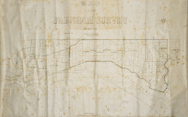
Map - Farnham Survey, 1850s
This is a map of the Farnham Special Survey. In 1843 William Rutledge purchased this Special Survey of 5,120 acres and named it Farnham. This Survey extended from Tower Hill to the Merri River at Dennington. The map appears to date from the 1850s This early map is of considerable significance as it shows details of the Farnham Special Survey. William Rutledge and his survey are important influences in the development of Warrnambool and district with the establishment of settlements at Killarney, Yangery and Tower Hill.A hand drawn map on waxed paper in brown, black and blue ink. It shows Armstrong's Bay, sea, Crown Land , the names of properties and some roads. It includes a compass direction diagram.farnham special survey -
 Bendigo Military Museum
Administrative record - Artillery Training No24 - The employment of Survey Batteries RAA in the Field, HQ RAA 6 Aust Div, 4 Dec 1944
Royal Australian Artillery (RAA) Survey Batteries in the field worked in conjunction with the Australian Survey Corps. This document provides guidance for that interaction. This document was onforwarded to the ExFortuna Survey Association from 4 Fd Svy Sqn in Aug 2024.18 pages of typed notes on letter sized paper, stapled top left corner. This is a photocopy of an original that is held at the Australian War Memorial ACT (AWM 52)royal australian survey corps, rasvy, fortuna, army survey regiment, army svy regt, asr, royal australian artillery, raa -
 Ringwood and District Historical Society
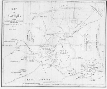
Photograph, Map of Melbourne & Vicinity - 1853. Survey of Port Phillip. Plan in Bonwick's "Settlement of Port Phillip"
Catalogue card reads, 'Map of Melbourne & Vicinity - 1853. Survey of Port Phillip. Plan in Bonwick's "Settlement of Port Phillip"'. -
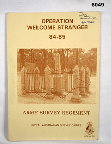 Bendigo Military Museum
Administrative record - Army Survey Regiment - Operation Welcome Stranger - Operation Report
Operation Report of Mapping areas in central Victoria in 29 Mar 84 - 6 Mar 85. Covering 1:250,000 map areas SJ54-4 St Arnaud, SJ 55-1 Bendigo, SJ54-8 Ballarat, SJ %%-2 WangarattaAn A4 booklet sepia cardboard cover, brown text Survey Corps Badge, Photo of " Welcome Stranger Monument", outline shape of Victoria, glide on Arnos fastener binder.royal australian survey corps, rasvy, fortuna, army survey regiment, army svy regt, asr -
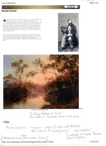 University of Melbourne, Burnley Campus Archives
Photograph - Web page, Sue Murphy et al, The Survey Paddock 1861, 1861-2011
Copy of Scan of photograph of painting in the National Gallery of Australia collection, "The Survey Paddock 1861" by Nicholas Chevalier. Donated by Sue Murphy (FOBG Committee) 17 March 2011.painting, national gallery of australia, the survey paddock, 1861, nicholas chevalier, sue murphy, fobg, survey paddock -
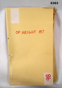 Bendigo Military Museum
Administrative record - Royal Australian Survey Corps Report on Operation Aright 87 conducted by 1 Field Survey Squadron 1987, 1 Fd Svy Sqn, 26 Aug 1987
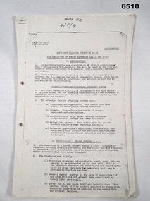
1 Fd Svy Sqn in conjunction with 2 Fd Svy Sqn conducted Operation Aright 87 in the Cape York Peninsula area over the period 8 May - 18 Jun 1987. The aim of the Survey Operation was to field verify the 70 x 1:50,000 map sheets which comprised the area of operations. This report details the activities conducted and the results achieved. Manilla Folder with title "OP ARIGHT 1987" containing a paper report of typed pages and diagrams bound together with an ARNOS fastener."OP ARIGHT 87" on front coverroyal australian survey corps, rasvy, fortuna, army survey regiment, army svy regt, asr -
Federation University Historical Collection
Book, Historic Sites Survey: North Central Study Area, 1979, 1979
The North Central Study Area included the Shires of Avoca, Bet Bet, east Loddon, Goulburn, Untly, Kara Kara, Korong, Maldon, Marong, Metcalfe, McIvor, Newstead, Strathfieldsaye, Stawell, Talbot, Clunes, Tullaroop and Waranga. 153 page book with white plastic binding. It is an historic sites survey for the North Central Study Area commissioned by the Land Conservation Council, the Ministry for COnservation and the Australian Heritage Commission. castlemaine, mount alexander goldfield, maldon, percydale, warrenmang, moliagul, tarnagulla, stuart mill, the whipstick, whroo, rushworth, graytown ironbark forest, st arnoaud, new bendigo, landsborough, inglewood, kurting, wedderburn, wehla, kooroora, langham flat, mcintyre, rheola, diamond hill, fosterville, coliban water works, green gully, newstead, muckleford forest, costerfield, graytown, bailieston, waranga irrigaiton system, eucalyptus distillery, mia mia bridge, korokubeal township researce, concegella slate quarry, chewton, fryerstown, kingower, timor, talbot, majorca, carisbroook, clunes, st arnaud, taradale, icomos, dunolly, limestone, castlemaine slate quarry, harcourt granite, taradale railway viaduct, loddon united waterworks trust, gouldburn weir, carisbrook lock-up, history of tree planting in streets, history of public reserves, r.u. nicholls nurseryman, thomas lang, francis moss, ballarat botanical gardens, ballarat school of mines botanical gardens, lake wendouree, victoria park, ballarat, muont holled smith, ballaarat old cemetery planting, eastern oval, ballarat east botanical gardens, ballarat east town hall gardens, eureka stockade reserve, ballarat observatory plantings, yarrowee creek plantings, yarrowee bluestone channels, ballarat woollen mill, band and albion mullock heap, black hill plantings, yarrowee creek channels, canadian creek channel, specimen vale channel, poverty point reserve, union jack reserve buninyong, imperial mine, buninyong, victoria street plantings, bridge mall, sturt street gardens, ballarat avenue of honour plantings, white flat oval plantings, camp street, elms, burnt creek -
Stawell Historical Society Inc
Map, Department of Lands and Survey, Borough of Stawell. Parishes of Stawell and Illawarra 1903, 1903
Victoria Co., St Georges Co., Wimerra Co., Leviathon Co. Tramway, Quarry reserve, Newington Co., Galatea Co., Moonlight Co., Federal Co., Borough reservior., A0 Map of Stawell on linen backing. Plus one Printed on PaperPhoto Lithograped at the Department of Lands and survey Melbourne by T.F. McGauran 13.6.03surevy