Showing 4068 items matching " surveying"
-
 Bendigo Military Museum
Pamphlet - Army Headquarters Survey Regiment Tour Booklet 1964, Army Headquarters Survey Regiment, Circa 1964
It is believed that this booklet was produced for visitors to a Fortuna Villa Open Day in 1964. Contains historical photos of the Fortuna Villa Entrance Hall and Music Room. Army Occupied Fortuna from 1942 - 1996.Printed buff coloured photo of Australia on a 4 x page folded A5 booklet. Contains a black printed Survey Corps badge , Surveyor characture and Title "Army Survey Headquarters Survey Regiment" on the cover. The booklet contains other selected early photographs of Fortuna and a diagram of the layout of the grounds. Pages 3 and 4 contain photographs and descriptions of Field surveying from the period."Public Inspection at 'Fortuna' Bendigo 10th May 1964" Donation 2/- royal australian survey corps, rasvy, fortuna, army survey regiment, army svy regt, asr -
 Bendigo Military Museum
Pamphlet - An Introduction to Topographic Mapping, C 1991
This pamphlet was published by the Army Survey Regiment as an overview of the Royal Australian Survey Corps (RASvy), its role and unit structure circa 1991, prior to RASvy’s disbandment in 1996. The pamphlet comprehensively detailed the eight steps of topographic map production: Establish Survey Control, Aerial Photography, Aerotriangulation, Stereoplotting, Field Verification, Cartography, Printing and Storage/Map Distribution. Leading technologies used by RA Svy in 1991 included GPS control surveys, 5 colour printing on the Speedmaster offset press and bulk map packaging using the Map Handling Station (with guillotine). Digital map production was operating on the AUTOMAP 2 system, before the “Newheart” system upgrade two years later. Printed on the pamphlet cover was a portion of the plane tabled “four inches to a mile” map of Newcastle. This was compiled and surveyed in 1910 by LCPL A. Barrett, a member of the RAE Detachment, as part of the first major topographic mapping effort of Australia.This is a Royal Australian Survey Corp pamphlet with a historical map printed in colour on cardboard on both sides of the cover. There are 16 pages printed in colour on gloss paper, with photos, diagrams and descriptions. The pamphlet is bounded by two staples on its spine. Each of the 17 images were scanned at 300 dpi in JPEG (.jpg) format and stored on the attached 16 Gb USB memory stick. The images have been converted into MPEG-4 (.mp4) video format, 4Mb in size and runs for 2:16 minutes and is also stored on the memory stick.royal australian survey corps, rasvy, fortuna, army survey regiment, army svy regt, asr -
 4th/19th Prince of Wales's Light Horse Regiment Unit History Room
Booklet, Australian Army Manual of Land Warfare Part 2 Artillery Training Vol 3 Pam 3 Gun Regiments Survey within the Unit 1983, 1983
Soft covered booklet describing the principles and process of battery survey in a field artillery battery and that within the regiment, and the role organisation duties and deployment of a regimental survey section 7610-66-108-8454artillery, survey -
 Bendigo Military Museum
Photograph - Photo Troop, Lithographic Squadron - Army Survey Regiment, Bendigo, 1989
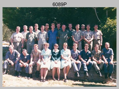
This is a photograph of Photo Troop, Lithographic Squadron; one of the Army Survey Regiment’s four squadrons, at Fortuna, Bendigo, December 1989. The main tasks undertaken by Photo Troop’s technicians were most likely photographic enlargements, reductions and duplication of map reproduction material, and processing of aerial photography.This is a photograph of Photo Troop Lithographic Squadron, Army Survey Regiment at Fortuna, Bendigo, 1989. The colour photograph was printed on photographic paper and is part of the Army Survey Regiment’s Collection. The photograph was scanned at 300 dpi. Back Row L to R: Rob Bogumil, Kevin ‘Chuck’ Berry, Andrew ‘Morrie’ Morrison-Evans, unidentified, Greg Howell, unidentified, Damien Cole, unidentified, Warren ‘Waldo’ Shirley, Steve Burke, Paul Baker, Bob Garritty, Frank Lenane, Bill Jones. Front Row L to R: John Bragg, Ken Peters, Gavin Craggs, Michelle Withers, Penny Knott, Di Chalmers, Geoff Webb, unidentified, Darren ‘Barney’ Maher, Kim Reynolds. No personnel are identified. Annotated on back with ‘Photo Troop Dec 1989’royal australian survey corps, rasvy, army survey regiment, army svy regt, fortuna, asr, litho -
 Bendigo Military Museum
Photograph - AHQ Survey Regiment Open Day - c1970, c1970
This is a set of thirty photographs of an Open Day held at the AHQ Survey Regiment, Bendigo c1970. It’s evident in these photos there was also a technical tour for dignitaries through the production areas in Air Survey, Cartographic and Lithographic Squadrons. It is known an Open Day coincided with the Freedom of Entry to the City Parade, an honour that was conferred by the Bendigo City Council to the AHQ Survey Regiment and held on the 14th of June 1970. As the CO LTCOL Bill Sprenger is positively identified, it’s highly probable these photos were taken at that time.This is a set of photographs of an Open Day held at the AHQ Survey Regiment, Bendigo c1970. The photographs were printed on photographic paper and are part of the Army Survey Regiment’s Collection. The photographs were scanned at 600 dpi. .1) to .17) - Photos, black and white. Unidentified personnel and civilian visitors. .18) and .19) - Photos, black and white. CO LTCOL Bill Sprenger is wearing Sam Browne belt. .18) and .19) - Photos, black and white. CO LTCOL Bill Sprenger is wearing Sam Browne belt. .20) and .21) - Photos, black and white. Left rear: SPR John Bennett .22) - Photo, black and white, c1970. Unidentified personnel and civilian visitors. .22) - Photo, black and white, c1970. Unidentified personnel and civilian visitors. .23) - Photo, black and white. L to R: 1st CO LTCOL Bill Sprenger, 3rd WO1 Joe Farrington .24) - Photo, black and white. L to R: 2nd SGT Bob Williams .25) - Photo, black and white. Unidentified personnel .26) - Photo, black and white. L to R: 2nd CO LTCOL Bill Sprenger. .27) to .30) - Photos, black and white. Unidentified personnel and civilian visitors.royal australian survey corps, rasvy, army survey regiment, army svy regt, fortuna, asr -
 Federation University Historical Collection
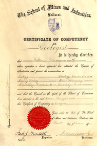
Certificate, Ballarat School of Mines Competency as a Geologist Certificate, o1/06/1911
... surveying ...William Baragwanath became Victorian Government Geologist. Cream coloured vellum certificate with blues Ballarat School of Mines Crest and red seal. It is a Ballarat School of Mines Certificate of Competency as a Geologist made out to William Baragwanath in 1911. The Certificate of Competency included passing examinations in Geology, Mining geology, Mineralogy, Petrology, Mine Surveying and Chemistry.Signed on left 'W. Baragwanath'ballarat school of mines, geology, petrology, mineralogy, surveying, chemistry, baragwanath, martell, frederick martell, maddern, geology alumni, william baragwanath -
Stawell Historical Society Inc
Map, Easton Johnstone, Map of Stawell Surveyed by Easton Johnstone 1872, 1872
Victoria Co Crushing Machine. St Georges Co Crushing machine. Wimmera Co Crushing Machine. Government Reservoir and Drainage. Sloan Street, Skene Street Mines. old Mine WorkingsA2 map of Stawell Reefs Area. Showing Crushing Machines & Title InfoSurveyed by Easton Johnstone Contract Surveyor. Photo-Lithographed at the Department of Lands & Survey. Melbourne By J Noone 9th May 1872mining -
 Bendigo Historical Society Inc.
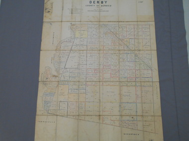
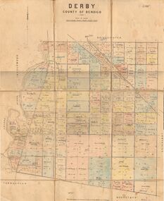
Map - JACK FLYNN COLLECTION: DERBY, 12/05/1892
Map: Derby, County of Bendigo. Parish plan.Department of Lands and Survey Melbourne by T.F.McGauran, 12.5.92map, bendigo, parish plan, derby -
 Bendigo Historical Society Inc.
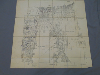
Map - JACK FLYNN COLLECTION: DERBY, 1/09/1909
Map: Derby, County of Bendigo. Parish plan.Dept of Lands and Survey, Melbourne by T.E.McGauran 1.9.09map, bendigo, parish plan, derby -
 Bendigo Historical Society Inc.
Map - JACK FLYNN COLLECTION: BET BET SHEET 2, 17/09/1931
Map: Parish of Bet Bet Sheet 2. Parish plan.Photo Lithographed at the Lands and Survey Melbourne. 17.9.31map, gladstone, parish plan, bet bet -
 Queenscliffe Maritime Museum
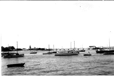
Photograph - Black & white photograph of the Ports & Harbour launch "Flinders" which was built c1940, Photographer unknown, Photographs
Photos of the Ports & Harbour launch "Flinders' at anchor.Realism, historicalBlack & white photograph of the Ports & Harbour launch "Flinders" at its mooring at QueenscliffeOn the reverse - " Ports & Harbours survey launch "Flinders" -
 Stawell Historical Society Inc
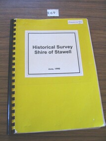
Book, Stawell & Halls Gap Historical Societies, Historical Survey Shire of Stawell June 1990, 1990
Bright Yellow card cover & white white paper with titleHistorical Survey Shire of Stawell June 1990stawell heritage -
 Bendigo Military Museum
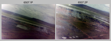
Photograph - 4th Field Survey Squadron – Operation NERVOSE 85 Field Phase Oblique Photos, NT, 1985
This is a set of 20 oblique aerial photographs taken during the field phase of 4th Field Survey Squadron’s Operation NERVOSE 85 project in the Northern Territory in 1985. Operation NERVOSE 85 was mounted by 4 Fd Svy Sqn in the EAST ARNHEM, VICTORIA RIVER DOWNS AND DALY WATERS areas of the Northern Territory from 26 May to 18 Sep 85. The aim of Operation NERVOSE 85 was to finalise the horizontal and vertical control for mapping at a scale of 1:50,000, to field check 40x 1:50,000 preliminary maps and to obtain mapping photography in support of the RAAF TINDAL redevelopment project. *Note –These photos were most likely taken in 1985, contrary to the ‘1987’ date annotated on the negative sleeves. The Op NERVOSE 85 Project Report available on RASVY’s web site lists a nominal roll of personnel. Photos of 4 Fd Svy Sqn taken in 1985 and 1987 provide names of posted personnel. Several personnel identified in these photos were posted to 4 Fd Svy Sqn in 1985, not in 1987. See items 6504.13P, 6505.28P and 6506.16P for more photos taken prior to and during Operation NERVOSE 1985. This is a set of 20 oblique aerial photographs taken during the field phase of 4th Field Survey Squadron’s Operation NERVOSE 85 project in the Northern Territory in 1985. The colour photographs on 35mm negative film and are part of the Army Survey Regiment’s Collection. The photographs were scanned at 96 dpi. .1) to .20) - Photo, colour, 1985. Unknown locations..1P to .20P – There are no personnel identified. ‘1987 OP NERVOSE VICTORIA RIVER DOWNS AND DALY WATERS.’ annotated on negative sleeve.royal australian survey corps, rasvy, 4 fd svy sqn, op nervose 85 -
Federation University Historical Collection
Report, City of Stawell Accessibility Study for the Disabled
A folder of information and surveys relating to disability access in Stawell -
 Ringwood and District Historical Society
Document - Copy of Lands Department Field Notes - Ringwood, Victoria, Field Notes 86.87/108 - Survey O.P. R72A dated August 1886 by Surveyor, L. Thorn
Foolscap size photocopies of survey maps with handwritten notations. -
 Ringwood and District Historical Society
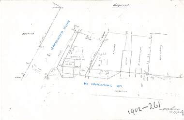
Document - Copy of Lands Department Field Notes - Ringwood, Victoria, Field Notes 1902/261 - Part of O.P. R72D surveyed 14.7.1902
Foolscap size photocopies of survey maps with handwritten notations. -
 Ringwood and District Historical Society
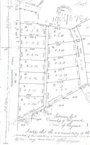
Document - Copy of Lands Department Field Notes - Subdivision Sec E, Township of Ringwood, Victoria, Field Notes 1908/670 - Survey O.P. R72E dated November 1908
Foolscap size photocopies of survey maps with handwritten notations. -
Stawell Historical Society Inc
Memorabilia - Realia, 1900's
One Chain Measure. Used for Survey or Farm Measurestawell -
Bendigo Historical Society Inc.
Map - GOLDEN SQUARE GEOLOGICAL SURVEY, 1992
BHS CollectionGolden Square Geological Survey of Goldfields Coloured map.Dept of manufacturing and Industry Development.bendigo, gold mining, geological survey -
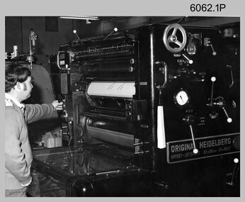 Bendigo Military Museum
Photograph - Original Heidelberg Printing Press at the Army Survey Regiment, c1980s, 1990
The first three photographs of the Original Heidelberg Printing Press were probably taken circa 1980s in Lithographic Squadron at the Army Survey Regiment, Fortuna, Bendigo. The last photo was taken in 1990. The Original Heidelberg Printing Press was a single colour offset press. It was a robust and well-made lithographic printing press and was in service at the Army Svy Regt for decades. Its primary use was for initial training and rapid response tasks, such as single pass overprints over existing print stock.This is a set of photographs of the Original Heidelberg Printing Press at the Army Survey Regiment, Bendigo c1980s, 1990. The photographs were printed on photographic paper and are part of the Army Survey Regiment’s Collection. The photographs were scanned at 300 dpi. .1) - Photo, black & white, c1980s, SPR Mick Ellis, Lithographic Squadron .2) - Photo, black & white, c1980s, unidentified, Lithographic Squadron .3) - Photo, black & white, c1980s, SPR Terry Winzar, Lithographic Squadron .4) - Photo, colour, 1990, Ni Vanuatu Printer Technicians, Lithographic Squadron.1 – personnel annotated .2 to .3 – no annotation .4 – annotated with dateroyal australian survey corps, rasvy, army survey regiment, army svy regt, fortuna, asr, litho, printing -
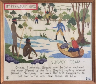 Kew Historical Society Inc
Textile - Bicentennial tapestry, 1. Survey Team, 8th February 1803, 1988
This is one of eight embroidered panels, completed during the 1988 Australian Bi-Centennial, and carried out under the auspices of City of Kew Council and the Kew Historical Society. Nearly 600 residents, including many children, participated in their production by adding a few or more stitches. A book records their names and the panels upon which they worked. Artist: Joy Stewart / Co-ordinator: Dorothy Benyei.1. Survey Team. A framed embroidery created by adults and children of the City of Kew as a Bicentennial project, based on a design by the artist Joy Stewart. Five of the six completed embroideries created in the project are/were displayed in the Kew Library. [The five embroidered panels have now been temporarily removed for conservation reasons].Inscription: "SURVEY TEAM 8th February 1803 / Grimes, Flemming, Robbins and McCallum explored the river (Yarra) to the falls (Dights), sighting several friendly Aborigines, and were the first Europeans to set foot in the area now known as Kew." Embroidered signature of the artist: "(c) JStewart, 1988"bicentennial project (kew), joy stewart, charles grimes expedition, australian bicentennial -
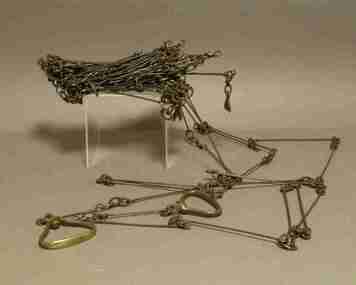 Federation University Historical Collection
Instrument - Survey Chain, Chesterman, Gunter's Survey Chain
... surveying ...Before metric measurement was introduced land was measured in chains and links. The chain was a precision part of a surveyor's equipment. It required frequent calibration, yet needed to be sturdy enough to be dragged through rough terrain for years. A standard survey chain is 66 feet (or 20.117m) long and made up of 100 links. Each link is 7.92 inches (approximately 201mm) long, measured from the inside of the loop. The handles are for tensioning the chain in use, they are not part of the length of the chain. In pre-metric units, there were 80 chains to 1 mile (equals 1.609km) This surveyor’s chain has an 8-inch link pitch, with markers at 10 link intervals. This metal surveyor’s chain (or Gunter's Chain) has an 8-inch link pitch, with markers at 10 link intervals, and handles at either end. A Surveyor’s Chain was 66 feet long, and made up of 100 links connected by two rings. A link in measurement includes the two rings at each end. gunter's chain, survey chain, surveyor s chain, perch, rood, surveying -
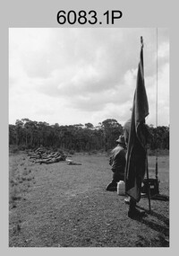 Bendigo Military Museum
Photograph - Army Survey Regiment - Regimental Training at Wellsford Rifle Range, Bendigo, 1985
This is a set of seven photographs of Army Survey Regiment personnel undertaking live fire SLR rifle qualification training at Wellsford Rifle Range, Bendigo 1985. This was the last of six regimental training objectives outlined in the administrative instruction – Exercise “City Soldier” accompanying these photos. The other objectives were SLR rifle and M30 grenade handling revision, and first aid at Fortuna; and navigation and RATEL at Wellsford Forest. Personnel from Air Survey, Cartographic, Lithographic and Headquarters Squadrons were reallocated to four training platoons for one week from 7th to 11th October 1985. Rifle shooting at Wellsford Rifle Range occurred for two days at the end of the week.This is a set of seven photographs of the Army Survey Regiment undertaking live fire rifle qualification training at Wellsford Rifle Range, Bendigo, 1985. Black & white photos .1P to .5P are printed on photographic paper and scanned at 300 dpi. Photos .6P to .7P are on 35mm negative film and scanned at 96 dpi. They are part of the Army Survey Regiment’s Collection. .1) - Photo, black & white, 1985, unidentified personnel. .2) - Photo, black & white, 1985, unidentified personnel. .3) - Photo, black & white, 1985, unidentified personnel. .4) - Photo, black & white, 1985, MAJ Terry Edward. .5) - Photo, black & white, 1985, unidentified US Army Exchange officer. .6) & .7) - Photo, black & white, 1985, unidentified rifle range safety officer..1P to .7P – No personnel are identifiedroyal australian survey corps, rasvy, army survey regiment, army svy regt, fortuna, asr -
 Bendigo Military Museum
Photograph - Army Survey Regiment - Regimental Training Field Phase, c1986
This is a set of eight photographs of Army Survey Regiment personnel undertaking regimental training in the Wellsford Forest, Bendigo, c1986. The aim of the training was to provide personnel a practical knowledge of infantry and minor tactics at the section level, navigation and map reading, RATEL and Survival in the Field. According to administrative instructions accompanying these photos, Air Survey, Cartographic, Lithographic and Headquarters Squadrons trained separately for one week from April to June 1986. Annotations on the back of photos .1P to .8P indicate Headquarters Squadron’s 4 Section in the ‘Axedale’ Forest. *Note - The forest was incorrectly named – It was most likely the training was in the Wellsford Forest. Sections were established for the period of regimental training only. This is a set of eight photographs of the Army Survey Regiment undertaking regimental training in the Wellsford Forest, Bendigo. c1986. The photographs were printed on photographic paper and are part of the Army Survey Regiment’s Collection. The photographs were scanned at 300 dpi. .1) - Photo, black & white, c1986, SGT Bruce Wetzig. .2) - Photo, black & white, c1986, PTE Tony Seely. .3) - Photo, black & white, c1986, SGT Bill Claydon. .4) - Photo, black & white, c1986, SGT Bill Claydon. .5) - Photo, black & white, c1986, SGT Gregory Smith. .6) - Photo, black & white, c1986, unidentified personnel. .7) - Photo, black & white, c1986, unidentified personnel. .8) - Photo, black & white, c1986, Mack water tanker..1P to .5P – Personnel are identified .6 to .8P – No personnel are identified Annotated ‘4 Section, Headquarters Squadron Axedale Forest’royal australian survey corps, rasvy, army survey regiment, army svy regt, fortuna, asr -
 Bendigo Military Museum
Photograph - Miss Victoria’s Visit to the Army Survey Regiment, Fortuna, Bendigo, 1986
This is a set of four photographs of a visit to the Army Survey Regiment by Miss Victoria on the 19th of April 1986. Her visit was hosted by the CO - LTCOL Don Swiney MBE. Although a list of Miss Victoria former winners is available on-line, the visitor is not identified as it is unclear she was the 1985 or 1986 winner. It is probable the presentation of the certificate in photo .1P was related to a fundraising donation by the unit to Miss Victoria’s charity.This is a set of four photographs of a visit to the Army Survey Regiment by Miss Victoria on the 19th of April 1986. The black & white photographs were printed on photographic paper and are part of the Army Survey Regiment’s Collection. The photographs were scanned at 300 dpi. .1) - Photo, black & white, 1986. L to R: Miss Victoria, MAJ Alex McLennan, LT Carol Dunstan, CPL Mick Minchin. .2) & .3) - Photo, black & white, 1986. L to R: Miss Victoria, CO - LTCOL Don Swiney MBE. .4) - Photo, black & white, 1986. Miss Victoria on the stairway to the top floor of Fortuna Villa.‘Miss Victoria Visit 1986' annotated on cover sleeve.royal australian survey corps, rasvy, army survey regiment, army svy regt, fortuna -
 Wodonga & District Historical Society Inc
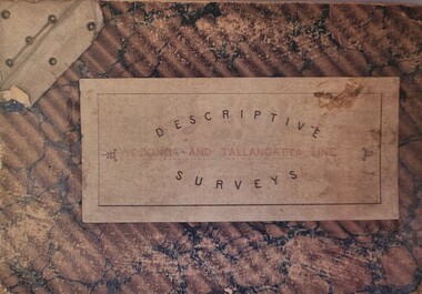
Booklet - Descriptive Surveys - Wodonga - Tallangatta Line
The first section of the Wodonga to Tallangatta line opened in 1889 and was further extended in 1891. It was a vital community link until the passenger service closed in September 1961. The last regular goods train on the line ran on 21st April 1978. These maps give detail of the surveying and building of the line.A collection of replicas of survey maps acquired to build the Wodonga to Tallangatta Railway line. Each survey includes a diagram of a portion of the line showing survey measurements and details of the land which that portion of the line will run through. It also includes the name of the landowner from whom the necessary land was acquired.The first section of the Wodonga to Tallangatta line opened in 1889 and was further extended in 1891. It was a vital community link until the passenger service closed in September 1961. The last regular goods train on the line ran on 21st April 1978. These maps give detail of the surveying and building of the line.victorian railways, wodonga to tallangatta rail service -
 Bendigo Military Museum
Photograph - Lithographic Squadron Awards, Army Survey Regiment, Fortuna Villa Bendigo, 1987
This is a set of 8 photographs of Lithographic Squadron award recipients, taken at the Army Survey Regiment, Bendigo in 1987.This is a set of 8 photographs of Lithographic Squadron award recipients, taken at the Army Survey Regiment, Bendigo in 1987. The photographs are on 35mm negative film and were scanned at 96 dpi. They are part of the Army Survey Regiment’s Collection. .1) - Photo, black & white, 1987, Lithographic Squadron award recipient: CPL Roy Hicks. .2) - Photo, black & white, 1987, Lithographic Squadron award recipient: LCPL Daryl South. .3) - Photo, black & white, 1987, Lithographic Squadron award recipient: SPR Graeme Spong. .4) - Photo, black & white, 1987, Lithographic Squadron award recipient: CPL Kerron South .5) - Photo, black & white, 1987, Lithographic Squadron award recipient: LCPL Damien Cole .6) - Photo, black & white, 1987, Lithographic Squadron award recipient: SPR Shona Hastie. .7) & .8) - Photo, black & white, 1987, Back Row L to R: CPL Roy Hicks, SPR Graeme Spong, SPR Shona Hastie, LCPL Damien Cole. Front row L to R: CPL Kerron South, LCPL Daryl South..1P to .8P – ‘Litho Awards 87’. royal australian survey corps, rasvy, army survey regiment, army svy regt, fortuna, asr, litho -
 Bendigo Military Museum
Photograph - Records Hut Personnel – Army Survey Regiment, Fortuna, Bendigo, c1986
These four photos of RaSVY personnel were taken inside the Records Hut, one of Headquarters Squadron’s work areas at the Army Survey Regiment, Fortuna probably in 1986. This building was located near the basketball court and probably at that time, held aerial photography archives, flight planning records, production data folders and final colour separated negatives of published maps.This is a set of two photographs of Records Hut personnel from Headquarters Squadron, Army Survey Regiment, Fortuna, Bendigo, 1986. The photographs were on 35mm negative film and were scanned at 96 dpi. They are part of the Army Survey Regiment’s Collection. .1) - Photo, black & white, 1986, Records Hut – SPR Brett Treneman. .2) - Photo, black & white, 1986, Records Hut – LCPL Bob Sheppard. .3) - Photo, black & white, 1986, Records Hut – L to R: LCPL Bob Sheppard, SPR Brett Treneman. .4) - Photo, black & white, 1986, Records Hut – L to R: LCPL Bob Sheppard, SPR Brett Treneman.No personnel are identifiedroyal australian survey corps, rasvy, army survey regiment, army svy regt, fortuna, asr -
Clunes Museum
Map - PLAN / MAP
.1 MAP, TOWN OF CLUNES, PARISH OF CLUNES, COUNTY OF TALBOT, STAMPED BOROUGH OF CLUNES .2 PLAN OF SUBDIVISION OF PART OF CLUNES COMMON, BOROUGH OF CLUNES, PARISH OF CLUNES,COUNTY OF TALBOT. P. CAMPBELL. ASSISTANT SURVEYOR, MARCH 1904 ON RIGHT HAND BOTTOM CORNER C71/1 CLUNES COMMON. MARKED: CHARTED R.L.A.7/2/57.1 PHOTO LITHOGRAPHED. DEPARTMENT OF LANDS AND SURVEY, MELBOURNE .2 PHOTO LITHOGRAPHED AT THE DEP. OF LANDS AND SURVEY, MELBOURNE PRICE 1/- 10.11.08map town of clunes, borough of clunes, parish of clunes, county of talbot -
 Bendigo Military Museum
Photograph - Technical Tour of the Army Survey Regiment, 1963, c1965
These photographs were most likely taken in 1963 and c1965 on two separate occasions of an Australian Army General’s visit to the Army Survey Regiment, Fortuna, Bendigo. As there are no annotations on the photos, the exact date and the names of the Generals are unknown. Some RASvy personnel are positively identified. The technical tour included the photogrammetric and printing areas of the Regiment. The newly introduced Wild B8 stereo plotter featured in photo .2P and the M.A.N. Ultraman 3 Offset printing press probably featured in the background of photos .3P and .5P.This is a set of photographs of a visiting Australian Army General’s technical tour of the Army Survey Regiment, Bendigo. The photographs were printed on photographic paper and are part of the Army Survey Regiment’s Collection. The photographs were scanned at 300 dpi. .1) - Photo, black & white, c1965. L to R: unidentified General, CAPT Carol Castor .2) - Photo, black & white, c1965. L to R: unidentified, unidentified General, Director Survey - COL Don Macdonald AM, CO – LTCOL Frank Buckland OBE. .3) - Photo, black & white, c1965. L to R: 2LT Dennis Puniard, unidentified, unidentified General, CAPT Reg Smith, MAJ Don Ridge, WO1 Aub Harvey .4) - Photo, black & white, c1965. L to R: CAPT Reg Smith, unidentified General. .5) - Photo, black & white, 1963. L to R: WO2 Ken Rich, MAJ GEN Taylor, MAJ Bill Howarth..1 to .5 - annotated “Visit by General”royal australian survey corps, rasvy, army survey regiment, army svy regt, fortuna, asr, printing, air survey