Showing 620 items matching " tower hill"
-
 Surrey Hills Historical Society Collection
Photograph - 18 Tower Street, Surrey Hills, The Street Where You Live Project
... You Live Project Photograph 18 Tower Street, Surrey Hills ...Photos documenting this address as part of a photographic series undertaken by volunteer photographers during 2013 and 2014 for The Street Where You Live Project. This was organised through the Surrey Hills Neighbourhood Centre and covered the postcode 3127 in the cities of Boroondara and Whitehorse.These photos provide a snapshot of real estate in the suburbs of Mont Albert and Surrey Hills during a period of rapid change with many properties on large blocks demolished to create higher density residential development or renewal of single dwellings. At particular risk were properties not covered by heritage overlays, in particular interwar housing and post 1950's housing. -
 Surrey Hills Historical Society Collection
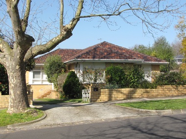
Photograph - 20 Tower Street, Surrey Hills, The Street Where You Live Project
... You Live Project Photograph 20 Tower Street, Surrey Hills ...Photos documenting this address as part of a photographic series undertaken by volunteer photographers during 2013 and 2014 for The Street Where You Live Project. This was organised through the Surrey Hills Neighbourhood Centre and covered the postcode 3127 in the cities of Boroondara and Whitehorse.These photos provide a snapshot of real estate in the suburbs of Mont Albert and Surrey Hills during a period of rapid change with many properties on large blocks demolished to create higher density residential development or renewal of single dwellings. At particular risk were properties not covered by heritage overlays, in particular interwar housing and post 1950's housing. -
 Surrey Hills Historical Society Collection
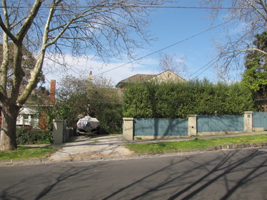
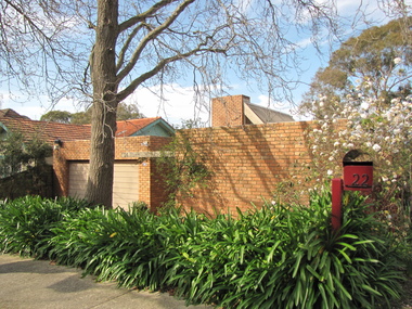
Photograph - 22 Tower Street, Surrey Hills, The Street Where You Live Project
... You Live Project Photograph 22 Tower Street, Surrey Hills ...Photos documenting this address as part of a photographic series undertaken by volunteer photographers during 2013 and 2014 for The Street Where You Live Project. This was organised through the Surrey Hills Neighbourhood Centre and covered the postcode 3127 in the cities of Boroondara and Whitehorse.These photos provide a snapshot of real estate in the suburbs of Mont Albert and Surrey Hills during a period of rapid change with many properties on large blocks demolished to create higher density residential development or renewal of single dwellings. At particular risk were properties not covered by heritage overlays, in particular interwar housing and post 1950's housing. -
 Surrey Hills Historical Society Collection
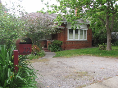
Photograph - 24 Tower Street, Surrey Hills, The Street Where You Live Project
... You Live Project Photograph 24 Tower Street, Surrey Hills ...Photos documenting this address as part of a photographic series undertaken by volunteer photographers during 2013 and 2014 for The Street Where You Live Project. This was organised through the Surrey Hills Neighbourhood Centre and covered the postcode 3127 in the cities of Boroondara and Whitehorse.These photos provide a snapshot of real estate in the suburbs of Mont Albert and Surrey Hills during a period of rapid change with many properties on large blocks demolished to create higher density residential development or renewal of single dwellings. At particular risk were properties not covered by heritage overlays, in particular interwar housing and post 1950's housing. -
 Surrey Hills Historical Society Collection
Photograph - 26 Tower Street, Surrey Hills, The Street Where You Live Project
... You Live Project Photograph 26 Tower Street, Surrey Hills ...Photos documenting this address as part of a photographic series undertaken by volunteer photographers during 2013 and 2014 for The Street Where You Live Project. This was organised through the Surrey Hills Neighbourhood Centre and covered the postcode 3127 in the cities of Boroondara and Whitehorse.These photos provide a snapshot of real estate in the suburbs of Mont Albert and Surrey Hills during a period of rapid change with many properties on large blocks demolished to create higher density residential development or renewal of single dwellings. At particular risk were properties not covered by heritage overlays, in particular interwar housing and post 1950's housing. -
 Surrey Hills Historical Society Collection
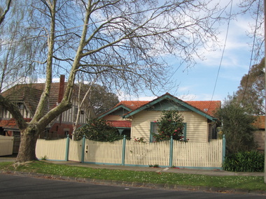
Photograph - 28 Tower Street, Surrey Hills, The Street Where You Live Project
... You Live Project Photograph 28 Tower Street, Surrey Hills ...Photos documenting this address as part of a photographic series undertaken by volunteer photographers during 2013 and 2014 for The Street Where You Live Project. This was organised through the Surrey Hills Neighbourhood Centre and covered the postcode 3127 in the cities of Boroondara and Whitehorse.These photos provide a snapshot of real estate in the suburbs of Mont Albert and Surrey Hills during a period of rapid change with many properties on large blocks demolished to create higher density residential development or renewal of single dwellings. At particular risk were properties not covered by heritage overlays, in particular interwar housing and post 1950's housing. -
 Surrey Hills Historical Society Collection
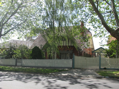
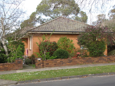
Photograph - 30 Tower Street, Surrey Hills, The Street Where You Live Project
... You Live Project Photograph 30 Tower Street, Surrey Hills ...Photos documenting this address as part of a photographic series undertaken by volunteer photographers during 2013 and 2014 for The Street Where You Live Project. This was organised through the Surrey Hills Neighbourhood Centre and covered the postcode 3127 in the cities of Boroondara and Whitehorse.These photos provide a snapshot of real estate in the suburbs of Mont Albert and Surrey Hills during a period of rapid change with many properties on large blocks demolished to create higher density residential development or renewal of single dwellings. At particular risk were properties not covered by heritage overlays, in particular interwar housing and post 1950's housing. -
 Surrey Hills Historical Society Collection
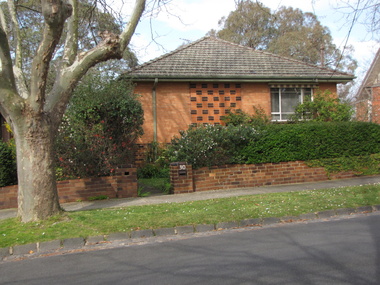
Photograph - 32 Tower Street, Surrey Hills, The Street Where You Live Project
... You Live Project Photograph 32 Tower Street, Surrey Hills ...Photos documenting this address as part of a photographic series undertaken by volunteer photographers during 2013 and 2014 for The Street Where You Live Project. This was organised through the Surrey Hills Neighbourhood Centre and covered the postcode 3127 in the cities of Boroondara and Whitehorse.These photos provide a snapshot of real estate in the suburbs of Mont Albert and Surrey Hills during a period of rapid change with many properties on large blocks demolished to create higher density residential development or renewal of single dwellings. At particular risk were properties not covered by heritage overlays, in particular interwar housing and post 1950's housing. -
 Kew Historical Society Inc
Plan, Melbourne & Metropolitan Board of Works : Borough of Kew : Detail Plan No.1585, 1904
The Melbourne and Metropolitan Board of Works (MMBW) plans were produced from the 1890s to the 1950s. They were crucial to the design and development of Melbourne's sewerage and drainage system. The plans, at a scale of 40 feet to 1 inch (1:480), provide a detailed historical record of Melbourne streetscapes and environmental features. Each plan covers one or two street blocks (roughly six streets), showing details of buildings, including garden layouts and ownership boundaries, and features such as laneways, drains, bridges, parks, municipal boundaries and other prominent landmarks as they existed at the time each plan was produced. (Source: State Library of Victoria)This plan forms part of a large group of MMBW plans and maps that was donated to the Society by the Mr Poulter, City Engineer of the City of Kew in 1989. Within this collection, thirty-five hand-coloured plans, backed with linen, are of statewide significance as they include annotations that provide details of construction materials used in buildings in the first decade of the 20th century as well as additional information about land ownership and usage. The copies in the Public Record Office Victoria and the State Library of Victoria are monochrome versions which do not denote building materials so that the maps in this collection are invaluable and unique tools for researchers and heritage consultants. A number of the plans are not held in the collection of the State Library of Victoria so they have the additional attribute of rarity.Original survey plan, issued by the MMBW to a contractor with responsibility for constructing sewers in the area identified on the plan within the Borough of Kew. The plan was at some stage hand-coloured, possibly by the contractor, but more likely by officers working in the Engineering Department of the Borough and later Town, then City of Kew. The hand-coloured sections of buildings on the plan were used to denote masonry or brick constructions (pink), weatherboard constructions (yellow), and public buildings (grey). This plan, which covers parts of High Street, Pakington Street and Derby Street is dominated by two historic Kew mansions: ‘Konetta’ and ‘Ramornie’. Ramornie was constructed in 1890 for James Maitland Campbell, three times Mayor of Kew. Sold in 1940, it became a boarding house known as ‘The Towers’. Now a private residence again, it has only one of its three balconies remaining. The location of the missing two balconies can be seen on the plan. In 1903, the grounds of Ramornie included a large tennis court fronting Pakington Street. The rear of the property is shown as extending to Cobden Street. One of Kew’s oldest hotels, the Prospect Hill Hotel on the corner of High and Cobden Street was established in 1858. The outline of the hotel shown on the plan represents the second building on the site. During the 19th century it was often used for electoral meetings. The Prospect Hill Hotel was to be redeveloped again in 1928, by the local architect Robert McIntyre. Since the 1980s, the hotel has been a live music venue, the home of the Melbourne Jazz Club, a restaurant and a liquor outlet.melbourne and metropolitan board of works, detail plans, maps - borough of kew, mmbw 1585, cartography -
 Kew Historical Society Inc
Archive (Sub-series) - Subject File, Buildings (Kew), 1964
Various partiesReference, Research, InformationSecondary Values (KHS Imposed Order)Subject file containing newspaper articles/clippings, research and correspondence from and to the Society. The earliest item, dating from 1964 is a letter from the Society to the City of Kew seeking Council support for the use of Ellesmore, 80 Princess Street as a cultural heritage centre. Other items of correspondence relate to the Masonic Hall (Walpole Street), Fernhurst, Southesk, Roberts House, Park Hill, Butleigh Wooton, Villa Alba, D’Estaville, Charleville, Roseneath, Merridale, La Verna, Otira, Raheen, Willsmere, Holy Trinity Church. Some of these letters contain information about construction of the buildings and architects. In addition to this correspondence, the file includes brief undated research notes on the Clock Tower at the Kew Cemetery, Tarring, Southesk, the Alexandra Gardens, Studley House (Burke Hall), Ellesmore, the Masonic Hall, Xavier College, Genazzano, Trinity Grammar, Carey Baptist College, Abbotsford, Fernhurst, Illapa, Madford, Morganville, Otira, Parkhill, Monnington, Field Place, Lalla Rookh, Merridale, Kew Mental Hospital, and D’Estaville.buildings -- kew (vic.), heritage -- kew (vic.)buildings -- kew (vic.), heritage -- kew (vic.) -
 Kew Historical Society Inc
Photograph, J F C Farquhar, Bird's Eye View Looking North, 1891
At the beginning of the 1890s, the Kew businessman and Town Councillor, Henry Kellett, commissioned J.F.C. Farquhar to photograph scenes of Kew. These scenes included panoramas as well as pastoral scenes. The resulting set of twelve photographs was assembled in an album, Kew Where We Live, from which customers could select images for purchase.The preamble to the album describes that the photographs used the ‘argentic bromide’ process, now more commonly known as the gelatine silver process. This form of dry plate photography allowed for the negatives to be kept for weeks before processing, hence its value in landscape photography. The resulting images were considered to be finely grained and everlasting. Evidence of the success of Henry Kellett’s venture can be seen today, in that some of the photographs are held in national collections.It is believed that the Kew Historical Society’s copy of the Kellett album is unique and that the photographs in the book were the first copies taken from the original plates. It is the first and most important series of images produced about Kew. The individual images have proved essential in identifying buildings and places of heritage value in the district.This panoramic view was probably taken from the roof of Xavier College. It invites the viewer to look down on the buildings and streets of Kew, and across to the distant horizon. Mansions and solid bourgeois villas dominate the view of Charles and Wellington Streets. The imposing spires of the Presbyterian and Methodist Churches, built in one of the highest areas of Kew, can be seen in the distance. In the foreground, the photographer includes three significant mansions: Molina, Roxeth and Elsinore. Molina, in the foreground, and the group of weatherboard buildings in its yard was used at this stage for the privately operated ‘Kew High School’ (founded 1872). Roxeth, the home of Herbert Henty can be identified by its distinctive four-sided tower. All three buildings are now part of Trinity Grammar. Other built structures observable in the photograph include Wilton (now the Kew RSL), designed by Guyon Purchas for Dr William Walsh in 1886, and the only known image of the Prospect Hill Hotel prior to the renovation of 1935. Bird's Eye View Looking Northkew illustrated, kew where we live, photographic books, henry kellett -
![View of portion of the City of Sandhurst, as seen from the hill, Camp Reserve / [by] Nicholas Caire, circa 1876](/media/collectors/550653872162f11fb04854aa/items/57774295d0cdd10a5c0eb588/item-media/57774325d0cdd10a5c0f0b71/item-fit-380x285.jpg) Kew Historical Society Inc
Kew Historical Society IncPhotograph, Anglo-Australasian Photographic Company, View of portion of the City of Sandhurst, as seen from the hill, Camp Reserve, c. 1876
Nicholas Caire was born on Guernsey in the Channel Islands in 1837. He arrived in Adelaide with his parents in about 1860. In 1867, following photographic journeys in Gippsland, he opened a studio in Adelaide. From 1870 to 1876 he lived and worked in Talbot in Central Victoria. In 1876 he purchased T. F. Chuck's studios in the Royal Arcade Melbourne. In 1885, following the introduction of dry plate photography, he began a series of landscape series, which were commercially successful. As a photographer, he travelled extensively through Victoria, photographing places few of his contemporaries had previously seen. He died in 1918. Reference: Jack Cato, 'Caire, Nicholas John (1837–1918)', Australian Dictionary of Biography, National Centre of Biography, Australian National University, http://adb.anu.edu.au/biography/caire-nicholas-john-3139/text3683, published first in hardcopy 1969, accessed online 1 July 2016.An original, rare photograph from the series 'Views of Victoria: General Series' by the photographer, Nicholas Caire (1837-1918). The series of 60 photographs that comprise the series was issued c. 1876 and reinforced a neo-Romantic view of the Australian landscape to which a growing nationalist movement would respond. Nicholas Caire was active as a photographer in Australia from 1858 until his death in 1918. His vision of the Australian bush and pioneer life had a counterpart in the works of Henry Lawson and other nationalist poets, authors and painters.Albumen Silver Photograph, mounted on Board.printed in ink on support l.c.: VIEW OF PORTION OF THE CITY OF SANDHURST, AS SEEN FROM THE HILL, CAMP RESERVE / COPYRIGHT REGISTERED. printed in ink on support reverse c.: VIEWS OF VICTORIA. / (GENERAL SERIES.) / No. 4. / VIEW OF PORTION OF THE CITY OF SANDHURST AS SEEN FROM THE HILL, CAMP RESERVE. / The Camp Reserve is the principal public promenade in this City. The Rotunda in the foreground, formerly used / by the local bands on festive occasions, is now regarded as a relic of the past. To the right of the picture is shown the / City of Sandhurst claim, supposed to be on the Hustler's line of reef. St. Paul's Church tower may be seen in the / distance. To the left of the picture Williamstown-street branches out from Pall Mall. On one side of the street is the / far-famed Shamrock Hotel; on the other stands the Bank of Australasia, with St. James's Hall immediately behind it. printed in ink on support reverse l.c.l.: J.W. FORBES, Agent, printed in ink on support reverse l.c.: ANGLO-AUSTRALASIAN PHOTOGRAPHIC COMPANY, MELBOURNE. printed in ink on support reverse l.c.r.: 10 Temple Court, Collins Street West.nicholas caire (1837-1918), landscape photography -
![View of Victoria Hill, Bendigo, taken from Old Chum Hill / [by] Nicholas Caire, circa 1876](/media/collectors/550653872162f11fb04854aa/items/577752a3d0cdd10a5c16e654/item-media/57775308d0cdd10a5c171c46/item-fit-380x285.jpg) Kew Historical Society Inc
Kew Historical Society IncPhotograph, Anglo-Australasian Photographic Company, View of Victoria Hill, Bendigo, taken from Old Chum Hill, c. 1876
Nicholas Caire was born on Guernsey in the Channel Islands in 1837. He arrived in Adelaide with his parents in about 1860. In 1867, following photographic journeys in Gippsland, he opened a studio in Adelaide. From 1870 to 1876 he lived and worked in Talbot in Central Victoria. In 1876 he purchased T. F. Chuck's studios in the Royal Arcade Melbourne. In 1885, following the introduction of dry plate photography, he began a series of landscape series, which were commercially successful. As a photographer, he travelled extensively through Victoria, photographing places few of his contemporaries had previously seen. He died in 1918. Reference: Jack Cato, 'Caire, Nicholas John (1837–1918)', Australian Dictionary of Biography.An original, rare photograph from the series 'Views of Victoria: General Series' by the photographer, Nicholas Caire (1837-1918). The series of 60 photographs that comprise the series was issued c. 1876 and reinforced a neo-Romantic view of the Australian landscape to which a growing nationalist movement would respond. Nicholas Caire was active as a photographer in Australia from 1858 until his death in 1918. His vision of the Australian bush and pioneer life had a counterpart in the works of Henry Lawson and other nationalist poets, authors and painters.Albumen silver photograph on boardprinted in ink on support l.c.: VIEW OF STURT STREET, BALLARAT, TAKEN FROM THE TOWN HALL TOWER. / COPYRIGHT REGISTERED. printed in ink on support reverse c.: VIEWS OF VICTORIA. / (GENERAL SERIES.) / No. 13. / VIEW OF VICTORIA HILL, BENDIGO, TAKEN FROM OLD CHUM HILL. / This scene represents two of the principal Quartz-reef claims in the district of Bendigo, with their surface / excavations. The one nearest the foreground is the North Old Chum's Company's claim, which is very rich with / gold-bearing quartz. The other claim, on the hill side, is the private property of Mr. George Lansell, and is even / more valuable than the former, giving employment to over 100 men. The building on the right is the quartz-crushing / plant belonging to the new Chum and Victoria Companies. The excavations are several hundred feet in depth. printed in ink on support reverse l.c.l.: J.W. FORBES, Agent, printed in ink on support reverse l.c.: ANGLO-AUSTRALASIAN PHOTOGRAPHIC COMPANY, MELBOURNE. printed in ink on support reverse l.c.r.: 10 Temple Court, Collins Street West.nicholas caire (1837-1918), landscape photography, victoria hill - bendigo - victoria -
 Kew Historical Society Inc
Photograph - 84 Princess Street (Kew), c. 1935
An item forming part of a collection of costumes, photographs and documents relating to the Weir family who lived in a mansion, originally named Illapa, at 84 Princess Street, Kew, from c.1917 to 1950. This historically significant collection includes items relating to both George Weir (1866-1937), his wife Edith Mary Weir (1867-1948) and their children. George Weir attained national prominence in the mining industry, becoming General Manager of the North Broken Hill Silver Mining Company in 1903 (later renamed North Broken Hill Mining Company 1905-12, and North Broken Hill Ltd 1912-1988), and subsequently President of the Mine Owners Association. He was to remain General Manager of North Broken Hill Ltd until his retirement in 1926.Sepia-toned photograph of 84 Princess Street, Kew during the occupation of the house by the Weir family during the years 1918-1950. The house and garden had formerly been named Illapa and then Parcnacilla. In 1950 the family sold the house to a religious order who renamed the house 'The Towers'. It now forms part of 'Rylands'.illapa -- 84 princess street -- kew (vic.), george weir, edith mary weir (nee betteridge), weir collection -
 Kew Historical Society Inc
Photograph - Studley Park (Kew), c.1949
An item forming part of a collection of costumes, photographs and documents relating to the Weir family who lived in a mansion, originally named Illapa, at 84 Princess Street, Kew, from c.1917 to 1950. This historically significant collection includes items relating to both George Weir (1866-1937), his wife Edith Mary Weir (1867-1948) and their children. George Weir attained national prominence in the mining industry, becoming General Manager of the North Broken Hill Silver Mining Company in 1903 (later renamed North Broken Hill Mining Company 1905-12, and North Broken Hill Ltd 1912-1988), and subsequently President of the Mine Owners Association. He was to remain General Manager of North Broken Hill Ltd until his retirement in 1926.Small black and white photograph of a panoramic view from the tower of 84 Princess Street, Kew during the occupation of the house by the Weir family during the years 1918-1950. The house and garden had formerly been named Illapa and then Parcnacilla. In 1950 the family sold the house to a religious order who renamed the house 'The Towers'. It now forms part of 'Rylands'.illapa -- 84 princess street -- kew (vic.), aerial photographs -- kew (vic.), studley park (kew) -1930s -
 Kew Historical Society Inc
Photograph - Entrance to Boroondara General Cemetery
Boroondara Cemetery, established in 1858, is within an unusual triangular reserve bounded by High Street, Park Hill Road and Victoria Park, Kew. The caretaker's lodge and administrative office (1860 designed by Charles Vickers, additions, 1866-1899 by Albert Purchas) form a picturesque two-storey brick structure with a slate roof and clock tower. A rotunda or shelter (1890, Albert Purchas) is located in the centre of the cemetery: this has an octagonal hipped roof with fish scale slates and a decorative brick base with a tessellated floor and timber seating. The cemetery is surrounded by a 2.7 metre high ornamental red brick wall (1895-96, Albert Purchas) with some sections of vertical iron palisades between brick pillars. Albert Purchas was a prominent Melbourne architect who was the Secretary of the Melbourne General Cemetery from 1852 to 1907 and Chairman of the Boroondara Cemetery Board of Trustees from 1867 to 1909. He made a significant contribution to the design of the Boroondara Cemetery. (Source: Heritage Victoria)This photograph is one of the earliest known photographs of the cemetery, showing the early plantings and fences.Later print copy of an undated original photographic positive of the entrance to the Boroondara General (Kew) Cemetery. The Cemetery had been opened in 1855. This view is from Bulleen Road (now High Street) showing a group of 12 or 13 men standing in a line outside the entrance. At this time, the clocktower and high brick fence had not been constructed, but the trees have reached a substantial heightPencil inscription on reverse - "Boroondara Cemetery Entrance 1862"boroondara general (kew) cemetery, cemeteries -- melbourne (vic.) -
Surrey Hills Historical Society Collection
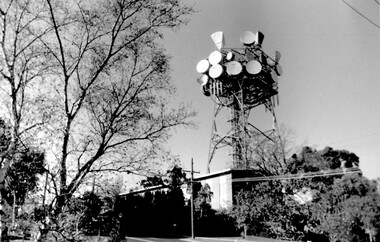
Map, Contour map of Surrey Hills showing potential sites for the Telecom Tower
... Hills showing potential sites for the Telecom Tower Map ...The PMG / Telecom / Telstra tower was built in 1961-1963 as a relay station to support television and radio links between city and regional broadcasting stations. The tower itself was 45 m in height with a 2 storey building for equipment and staff surrounded by garden. From the beginning it was opposed by local residents. The location is said to be the second highest site in Melbourne, sometimes described as Delaney's Hill.Two A3 photocopied sheets of a map showing part of Surrey Hills, roughly between Windsor Crescent and Belmont Street (north / south) and Standard Avenue and Balmoral Crescent (east / west). The map shows contour lines and house sites, 16 of which are numbered. One sheet has been inscribed in top RH corner with notes regarding the significance of the numbers."Contour map of potential sites / for the telecommunications tower which / was eventually sited at 2. / Jock Campbell OBE was our neighbour / at 4 Theodore St when we moved into / the area in 1984. He was responsible in his / job at the PMG in deciding on the /site of the tower - Note site 5 was / behind his (& our) house. / Jack ended his career as Deputy Director / of the PMG. He sat on international committees / after WW2 to decide the split of the electronic / spectrum for radio, TV etc. / His group developed a "mobile phone" using / fixed towers but the phone was a truck full of gear."contour map, telecom tower, maps, jock campbell, john duncan campbell -
 Surrey Hills Historical Society Collection
Book, Raheen: a house and its people, 2007
Raheen is a 120 year old Victorian house owned by Richard and Jeanne Pratt. Mrs Jeanne Pratt commissioned the book and this copy was presented to Sue Barnett on a visit by members of the Boroondara Historical Societies. The visit was organised by local member Mr Josh Frydenburg. 92p. ill. bibliog., Raheen was a grand two-storey red brick house in the Italianate Style, with a prominent tower and an arcaded loggia on two levels. This book explores its history, restoration and further development over many years. 92p. ill. bibliog., Raheen was a grand two-storey red brick house in the Italianate Style, with a prominent tower and an arcaded loggia on two levels. This book explores its history, restoration and further development over many years.Endpaper: Surrey Hills Historical Society / Jeanne Pratt / 27/7/2013(mr) ian allen oam, (mr) william lawrence bailieu, ehud barak, (dr) james broadbent, (mr) robert bruce, (mr) george h w bush, (mrs) barbara pierce bush, (mr) arthur calwell, (ms) jane dennithorne, (mr) eamon de valera, (sir) james augustine gobbo, (mr) lloyd hill, (mr) william morris hughes, (lord) (mr) immanuel jakobovits, (mr) philip johnson, (cardinal) (mr) walter kaspar, moshe katsav, (mr) james robert knox, (mr) terence lane, (mr) edward latham, (mr) michael lehany, (dr) (mr) miles lewis, (mr) sam lipski am, (sir) (mr) thomas francis little, (mr) peter lovell, (mr) egidio lunardon, (mr) (cardinal) jean-marie lustiger, (mr) daniel patrick mannix, (sir) (mr) robert gordon menzies, (mr) henry miller, (mr) glen murcutt ao, (mr) benjamin netanyahu, (mr) ngo dinh diem, (mr) phillip nikolitsis, i (eoh) m(eng) pei, (mr) shimon peres, (mr) joseph reed, (mr) yves st laurent, (mr) william salway, (mr) james henry scullin, jessie serle, (mr) justin david simonds, (mrs) heliose waislitz, (miss) heliose pratt, (mr) john wren, (sir) (mr) henry john wrixon, (mr) richard pratt, (mrs) jeanne pratt, raheen, historical buildings, kew, victoria, italianate style, house names -
 Surrey Hills Historical Society Collection
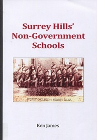
Book, Surrey Hills' Non-Government Schools, 2016
Provides background and history of the fifteen non-government (independant) schools in Surrey HillsProvides background and history of the fifteen non-government (independant) schools in Surrey Hills 124pschools - boroondara, st joseph's home and residential school, campden ladies college, surrey college, hessle school, ormiston college, ladies high school (jessie tait), surrey hills preparatory grammar school, surrey hills kindergarten and preparatory school, tower house school, craighall, milverton ladies college, our holy redeemer school, our lady's primary school, st andrew's presbyterian school, miss mccleverty's girls high school, (mr) ken james, st brigids, jessie tait -
 Surrey Hills Historical Society Collection
Photo, Telecom tower, Canterbury Road
This photo of the Telecom Tower was one of a series of photos taken of landmarks and houses of the area by Ken Hall in c1980. The PMG / Telecom / Telstra tower was built in 1961-1963 as a relay station to support television and radio links between city and regional broadcasting stations. The tower itself was 45 m in height with a 2 storey building for equipment and staff surrounded by garden. From the beginning it was opposed by local residents. In response to a Telstra application to replace it with a 40m slimline monopole, the City of Whitehorse controversially sought to have the structure heritage-listed, a move which caused much debate. In May 2015 Council ultimately rescinded its decision and gave permission for demolition, however Telstra deemed the permit conditions to be too restrictive and decided to continue to use the tower. The permit (to replace the tower) expired in September 2017. A black and white photo of local landmark visible from many vantage points in Surrey Hills and surrounding area, as it was built on the high point of the area.telecommunications tower, city of whitehorse, heritage overlay, heritage study, development, pmg tower, telstra, telecom, harding street, canterbury road -
 Surrey Hills Historical Society Collection
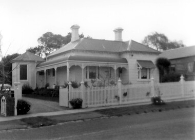
Photograph, 10 Pembroke Street, Surrey Hills
‘Eignbrook’ at 10 Pembroke Street was built 1904. Until the 1950s this area was the highest spot in the metropolitan area and ships in the Bay could be seen from ground level and views extended almost 360 degrees. A number of homes of this Edwardian period had viewing towers, the one in the photo being that of ‘Maroondah’ at 12 Pembroke Street. Photo taken by W V Hill. Courtesy: Mr William (Bill) Dempsey. Original sepia photograph of a weatherboard home in the Queen Anne style. It has a steep pitched iron roof. It has a woven wire fence across the front of the property and decorative gates. Mounted on white cardboard photo taped on 2 corners.Back of photo is inscribed “Hills, 10 Pembroke St, Surrey Hills”. Card has written underneath the photo, “10 Pembroke St, Home of Hills family, built 1904”pembroke street, house names, surrey hills, hills family, 'maroondah', 'eignbrook', (mr) w v hill, (mr) william (bill) dempsey, journalist, queen anne style, (mrs) annie hill -
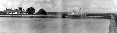 Surrey Hills Historical Society Collection
Photograph, Surrey Hills Reservoir No 1
... and the accompanying tower was built in 1929. It is assumed that the Miss Hill ...Copied by Ken Hall from an early postcard. This is Surrey Hills Reservoir No 1 on the corner of Tower Street built in c1892 at a cost of £12,000 to supply higher sections of the area. The builders were Jack and Bob Laudehr, partners in a wood yard in St. Kilda (Vic). They began by delivering firewood but extended to contract work involving timber. Another of their projects was to lay cable tram tracks commencing in Acland Street St. Kilda and running along The Esplanade. The reservoir in Canterbury Road was a large concrete structure built before the introduction of reinforcements. The excavated material was banked against the sides and pine trees were planted in it to add strength to the embankment. They were paid £2,000 for their work. Construction of Surrey Hills Number 2 Reservoir was completed in 1913 and the accompanying tower was built in 1929. It is assumed that the Miss Hill as the source of the donation (via Bill Dempsey) was Ivy Annie Hill (1902-1984). She was the only female child of William Valentine Dempsey to not marry. Bill Dempsey's mother was Laura Constance 'Birdie' Hill (1900-1968) who married Albert Dempsey.A sepia photograph within a post card of a reservoir on Canterbury Road, Surrey Hills. In the background to the left you can see the top halves of two houses and the tops of some trees. The photo takes up only the central section of the postcard.Below the photo on the front of the postcard on blue biro "Reservor [sic] Canterbury Rd / Surrey Hills." On the rear in grey lead pencil in Jocelyn Hall's handwriting: "Donor W Dempsey ------------- Keep / (nephew) / [arrow pointing down] / From Miss Hill / 10 Pembroke St SH / This house can be / seen in front of / No 12 which has / tower"1890, water supply, mmbw, edward d dyer (mr), 10 pembroke street, 12 pembroke street, surrey hills, ivy annie hill (miss), william valentine hill (mr), canterbury road, tower street, water supply structures and establishments, dams and reservoirs, jack laudehr (mr), bob laudehr (mr) -
 Surrey Hills Historical Society Collection
Photograph, 'Garmure', 26 Russell Street, Surrey Hills in 1988
‘Garmure’, 26 Russell Street, Surrey Hills was built c. 1887 and renovated c1988. This photo was taken after renovation of the rear of the house when the corner tower was added. Occupants: 1890: Mr Caffin 1910: Miss Agnes Campbell Hutchinson Orr 1930 – 1988: Sextons Miss Orr was born in Hutchesontown, Glasgow to Francis Orr (1834-1859) and Jane McDonald. Her father died soon after her birth and her mother married Thomas Blood. She had a half-brother Robert McDonald Blood. In 1903 she, her brother and mother were living in Boundary Road. She is buried with them in Kew Cemetery. She died aged 57 on 1 December 1926. A black and white photograph of a Queen Anne Style weatherboard house with a return veranda. The roof is corrugated iron. There is a picket fence along the front and a driveway on the left had side of the building.garmure, house names, (mr) - caffin, sexton family, queen anne style, corrugated iron, weatherboard, russell street, surrey hills, (miss) agnes campbell hutchinson orr -
 Surrey Hills Historical Society Collection
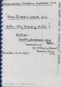
Book, Dorothy Selby (nee Emerson), How green were my hills - my Surrey Hills, September 1979
A biographical history by Dorothy Selby (nee Emerson) recollecting the people she came into contact with during her time in Surrey Hills from 1915-1937.A4, comb binding, 9 pageshouse names, kookaburra, albany crescent, surrey hills, (miss) dorothy emerson, (mrs) dorothy emerson, warrigal road, boundary road, st stephen's presbyterian church, (mrs) - gillies, (mr) tom ward, dentist, (mrs) - bowen, edwardian style, royal hotel, broughton road, (mrs) - brogan, (mr) - brogan, (mr) - tuckett, tacey's butcher, (mr) james tait, draper, (mr) alfred rose, state savings bank, surrey college, tower house college, balmoral crescent, (mr) - clewett, (mr) percy blood, stenning and holyoak, grocers, (mr) - pell, greengrocer, confectioner, fishmonger, (mr) tommy everon, (miss) beatrice bligh, (mr) - lyons, (mr) - ray, surrey hills station, transport, (ms) kitty mcewan, golfer, taxis, (mr) - collins, surrey hills primary school, (dr) (mr) - forsythe, (dr) (mr) - gandever, windsor crescent, valonia avenue, victoria avenue, (mr) john blogg, progress association, rechabite hall, (mr) claude wardle, (miss) beatrice oakley, empire day, (mr) robert gordon menzies, girl guides, (ms) nancy steele, (ms) hattie steele, (dr) (mr) - blaikie, (mr) - richards, stationmaster, crime, (mr) - cockerill, (mr) horrie breedon, first enlistment, (mr) (rev) brazier, (mr) (rev) - oakes, (mr) (rev) - gillies, (mr) (rev) - mudford, (mr) (rev) - millikan, (mr) (rev) - cockett, (mr) (rev) alfred gifford, (mr) (fr) david gleeson -
 Surrey Hills Historical Society Collection
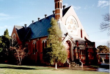
Photograph, St Stephen's Presbyterian Church, Surrey Hills, viewed from Warrigal Road, 1980's
The first service of the Surrey Hills Presbyterian Church was held at ‘Kinnoul’, the home of Thomas Hogg, located in The Avenue. This was while the church was being built. St Stephens Presbyterian Church opened in March 1899 on land that had previously been part of Klepper's orchard. The first minister was Rev F A Darling. He resigned in 1892 to open Surrey College. The church building pictured was built in 1910 adjacent on land gifted to the church. Noted features of the interior are the pulpit and honor board carved by sculptor John Kendrick Blogg. There are also memorial windows to Charles de Burgh Hogg and William Thomas Hogg, both killed in WW1.Red brick church with bell tower and slate roof. Cyprus tree at side; other trees fronting Canterbury Road.Canterbury Road - Warrigal Rd (written in biro on th back of photo)stained glass, lead lights, churches, presbyterian church, st stephens presbyterian church, 1980-1989, surrey hills, canterbury road, warrigal road, john kendrick blogg, charles de burgh hogg, thomas william hogg -
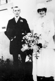 Surrey Hills Historical Society Collection
Photograph, Wedding Day of Amelia Amy Jacobs and James Dodgshun from Surrey Hills, 1916
Amelia Allan (Amy) Jacobs on her marriage to James Dodgshun in 1916; photographed at the home of her grandfather, "Terreglea" in Boundary (Warrigal) Road, Surrey Hills. Amelia attended Ormiston Girls' School in Mont Albert soon after its opening in 1900. Her mother was Eleanor Mills, youngest daughter of Robert Shortbridge Mills and Ann Lovelady. She died soon after the birth of Amy. Her father was Henry Atwood Jacobs. Following Eleanor's death Henry married Amy Lilian Scales. The donor Winifred Yarnold (nee Jacobs) was their youngest daughter and Amy's half-sister.Lady dressed as bride wearing a white dress and possibly a lace jacket with a fluffy collar and matching hat, carrying a large bouquet of flowers. The man is wearing a dark suit and carrying a top hat.wedding dresses, house names, surrey hills, warrigal road, clothing and dress, hats, terreglea, the tower house, weddings, wedding parties, ormiston girls school, schools, mont albert, miss amelia allan jacobs, miss amy jacobs, mr james dodgshun -
 Surrey Hills Historical Society Collection
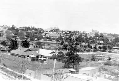
Photograph, Surrey Hills looking south-east from the steeple of Holy Trinity Church, 1921, 1921
The property in the foreground is 'Edgeware' at 171 Union Road, a house built by the Zeplin family. It became the home / residence of Dr Percy Liddle and later Dr James Landells Blakie. By the time this photo was taken Dr Blakie had moved across the road to 174 Union Road. In the background behind the 2 houses in the foreground is the Surrey Hills Stationmaster's house, sitting behind a picket fence. The Alan Holt register gives a build date of c1915 for this house, which fits stylistically. The first stationmaster was probably Michael Ginnane, who stayed in the area after he retired, moving to 1 Russell Street. This property was listed as 8 Bedford Avenue, the only house on the south side of the road. It was demolished in c1972 to make way for widening of the rail track with a third line. The photographer Norman Carter took many photos of Surrey Hills and Mont Albert from the 1920s, in particular of events and activities associated with the Church of England.Black and white photo taken from the steeple of Holy Trinity Church looking across housing towards the railway line and Albany / Windsor Crescents and on towards Canterbury Road. Surrey Hills Primary School and St Stephens Presbyterian Church feature prominently on the horizon. The stationmaster's cottage is centre left adjacent to a large conifer-like tree, with a white fence delineating the railway yards.On back of original: "6-11-21" and in a different hand in biro: "from tower of Holy Trinity Church"albany crescent, windsor crescent, st stephens presbyterian church, surrey hills primary school, railways, stationmasters' houses, bedford avenue, norman carter, edgeware, dr percy liddle, dr james blakie -
 Surrey Hills Historical Society Collection
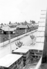
Photograph, Union Road looking west from the steeple of Holy Trinity Church, 1922, 1922
At the edge of the church roof and on the horizon is 'The Knoll' on the corner of Union Road and Wandsworth Road. To the left of this is 297 Mont Albert Road, home of the Michael Parer family and further left is "Quamby", home of the Sherar family. This is easily recognised by the square viewing tower located on the west wing of the house. The Sherar family owned 'Quamby' from 1900 until 1925, when it became Mosgiel Private Hospital. Norman Carter took many photos of Surrey Hills and Mont Albert in the 1920s; many associated with events and activities of the Church of England. Black and white photo of taken from the steeple of Holy Trinity Church, during its construction, across Union Road to the north-west. In the foreground immature street trees can be seen and an original telephone pole with white insulators. The street has formed paths and bluestone kerb and channelling. holy trinity anglican church, union road, the knoll, quamby, street trees, telegraph and light poles, mosgiel hospital -
 Surrey Hills Historical Society Collection
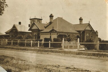
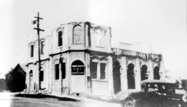
Photograph, Demolition of Tower House Day and Boarding School, Surrey Hills in 1932 (1)
This building dated back to the 1880s and had previously operated as Delany's Hotel and then the Royal Hotel. It was built near the site of the original Delany's Hotel, built in 1856. The Royal Hotel closed in 1921 after the area voted to be a 'dry area' in the local option poll. Tower House Day and Boarding School operated from 1921 until 1932. Norman Carter took many photos of Surrey Hills and Mont Albert from the 1920s; many were associated with events and activities of the Church of England.Black and white photo of a partially demolished building. The roof and part of the second storey are missing. What remains indicates that it has been a large building in the Victorian style. Along one side at ground level there are 4 arches, perhaps entry to a covered veranda, above which is a colonnade, and perhaps an open veranda on the upper level. There is a mixture of treatments to the surrounds of the windows. On the corner, within an arch which may have once been a doorway, is a sign reading: "TOWER HOUSE / DAY / & / BOARDING SCHOOL". There is a car with a retractable hood in the lower RH Corner of the photo.Rear top centre in blue biro "1932" (crossed out); top RH corner "498" in red biro; centre "Demolition of / Tower House Day & Boarding / cr Canterbury & Broughton Rds / previously Tower House Hotel / originally Royal Hotel / See partner photo."; bottom RH cnr "demol (in red biro) / 20-8-32". All in Jocelyn Hall's handwriting.tower house day and boarding school, schools, education, royal hotel, hotels, construction and demolition, dry area, licensing polls, temperance movement, delany's hotel, norman carter -
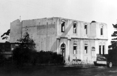 Surrey Hills Historical Society Collection
Photograph, Demolition of Tower House Day and Boarding School, Surrey Hills in 1932 (2), 20/08/1932
This building dated back to the 1880s and had previously operated as Delany's Hotel and then the Royal Hotel. It was built near the site of the original Delany's Hotel, built in 1856. The Royal Hotel closed in 1921 after the area voted to be a 'dry area'. Tower House Day and Boarding School operated from 1921 until 1932. Norman Carter took many photos of Surrey Hills and Mont Albert from the 1920s; many were associated with events and activities of the Church of England.Black and white photo of a partially demolished building. The roof is missing and there is a pile of rubble along the front wall. What remains indicates that it has been a large building in the Victorian style. There is a mixture of treatments to the surrounds of the windows. On the RHS part of a truck can be seen.Original: Top LH corner in blue biro "see matching photo"; top RH corner "498 / spare"; bottom LH corner in lead pencil "N Carter"; bottom RH corner in blue biro "20-8-32" - all Jocelyn Hall's handwriting.tower house day and boarding school, schools, education, royal hotel, hotels, construction and demolition, dry area, licensing polls, temperance movement, delany's hotel, norman carter