Showing 939 items
matching annotations
-
 Bendigo Military Museum
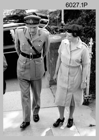
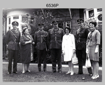
Photograph - Technical Tour of the Army Survey Regiment, 1963, c1965
These photographs were most likely taken in 1963 and c1965 on two separate occasions of an Australian Army General’s visit to the Army Survey Regiment, Fortuna, Bendigo. As there are no annotations on the photos, the exact date and the names of the Generals are unknown. Some RASvy personnel are positively identified. The technical tour included the photogrammetric and printing areas of the Regiment. The newly introduced Wild B8 stereo plotter featured in photo .2P and the M.A.N. Ultraman 3 Offset printing press probably featured in the background of photos .3P and .5P.This is a set of photographs of a visiting Australian Army General’s technical tour of the Army Survey Regiment, Bendigo. The photographs were printed on photographic paper and are part of the Army Survey Regiment’s Collection. The photographs were scanned at 300 dpi. .1) - Photo, black & white, c1965. L to R: unidentified General, CAPT Carol Castor .2) - Photo, black & white, c1965. L to R: unidentified, unidentified General, Director Survey - COL Don Macdonald AM, CO – LTCOL Frank Buckland OBE. .3) - Photo, black & white, c1965. L to R: 2LT Dennis Puniard, unidentified, unidentified General, CAPT Reg Smith, MAJ Don Ridge, WO1 Aub Harvey .4) - Photo, black & white, c1965. L to R: CAPT Reg Smith, unidentified General. .5) - Photo, black & white, 1963. L to R: WO2 Ken Rich, MAJ GEN Taylor, MAJ Bill Howarth..1 to .5 - annotated “Visit by General”royal australian survey corps, rasvy, army survey regiment, army svy regt, fortuna, asr, printing, air survey -
 Glenelg Shire Council Cultural Collection
Photograph - Photograph - Aerial Photo railway line between Heywood and Rennick, 03/05/1952
Victorian Railways aerial survey record print of the railway line between Heywood and Rennick (S.A. border) Black and white, white vertical strip on imageFront: Annotations in black texta added at a later date Back: 'Heywood - Rennick 21451 - 19722 267m 1c ' - all black ink. Purple VR aerial survey stamp. '3 May 1952' - black stamp -
 Chiltern Athenaeum Trust
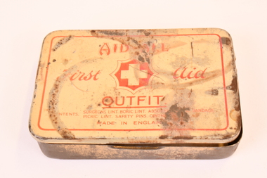
Aid All Pre WW2 British First Aid Outfit Tin - White Cross, pre WW2 1940
Associated with issue to personnel leading up to and including WW2 in Britain . Circa pre 1940's. Associated with issue during WW2. Small cream coloured tin with white cross centrally placed on the lid. Tin opens with hinges and has wording on the lid "Aid A;; First Aid Outfit Tin made in England". There is a faded description of the contents. Within the tin is a smaller cream and red coloured circular tin containing boric ointment. The first aid outfit tin is 130mm x 75 and the small circular tin with boric ointment is 35mm x 35mm. The lid of the tin says : Aid All First Aid, a white cross emblem and underneath the emblem the wording OUTFIT TIN. There is a description of the items and then the annotation that the tin is made in England. Both tins are cream in colour with red edgings. aid all first aid outfit tin pre 1940's, white cross first aid outfit tin, pre ww2 and ww2 issue -
![Construction of the electric tram line in Cotham Road [Kew]](/media/collectors/550653872162f11fb04854aa/items/662870846214a76cee3aecf0/item-media/662870de6214a76cee3af7de/item-fit-380x285.jpg) Kew Historical Society Inc
Kew Historical Society IncPhotograph - Construction of the electric tram line in Cotham Road [Kew], E.J. Dower, 1913
One of a small album of six photographs of the construction of the Cotham Road tramline in Kew, taken by Edgar James Dower in the second decade of the twentieth century. The reverse of each photo contains notes, written over time by the photographer, which are contained in the 'Inscriptions' field. Born and raised in Olinda, Dower's family later moved to Surrey Hills. He worked as an adult as a clerk in the city office of the Metropolitan Gas Company, and in his role as a 'collector', he was able to photograph scenes including the construction of tram and train lines and associated buildings in Kew, Hawthorn, Camberwell and Surrey Hills. Later he established a real estate agency with his brother - the E.J. Dower Real Estate Agency, Dandenong Office. The album as a whole can be viewed separately as the parent file.The image is an historically significant record of the development of transport infrastructure which was used to connect Victorians in the first two decades of the twentieth century. This development resulted from increases in population and the consequent extension of Melbourne's suburbs. The photographs in the album, as well as Dower's single photos mounted on card, individually and collectively richly detail the labour of workers and the tools and machinery used to create and extend Melbourne's tram and train networks in the years preceding and during World War 1.The first of six annotated photos in an album of photographs of the construction of the St Kilda to Kew electric tram line, taken in Cotham Road, Kew, by the amateur photographer, Edgar James Dower, in 1913. The album contains images detailing the preparation for the laying of the tracks plus work laying the line. The photographer notes on a number of the photos that te metal tracks were collected from the Hawthorn railway siding. The album, together with other phots by E.J. Dower has been made available by the owners for the Kew Historical Society to digitise and publish online and in print.Annotation verso: "1913 / Preparing for electric trams in Cotham Road Kew, looking west / Taken from corner of Burke Road by E.J. Dower / The metal was brought by horse and drays, from Hawthorn rail-way siding".keywords, theme -- connecting victorians by transport and communications, theme -- travelling by tram, photographers -- edgar james dower, cotham road -- kew (vic.) -
 Kew Historical Society Inc
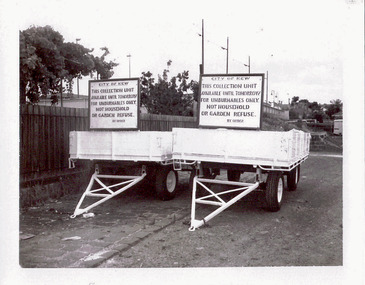
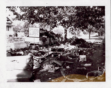
Photograph - Hard rubbish trailers
One of eight photographs donated by the City Engineer of the former City of Kew, mostly of hard rubbish clearance during the period 1969-1985.One of a dated series of photographs of core local government services as practised by the City of Kew in the period 1969-1985. Original black and white photographic positive of rubbish collection units (trailers) used within the City of Kew in and around 1980. Both trailers display the same sign reading: "City of Kew This collection unit available until tomorrow for unburnables only. Not household or garden refuse. By Order" Stamp - J86K431 Annotation in ink on reverse: "Rubbish Units 18/1/80'. In envelope marked: "Kew City Council 12 photos / 1969 1979 18980 1985 / Unburnable rubbish units 18/1/80"garbage, hard rubbish, garbage removal, city of kew, local government -- city of kew, household waste, hard waste -
 Warrnambool and District Historical Society Inc.
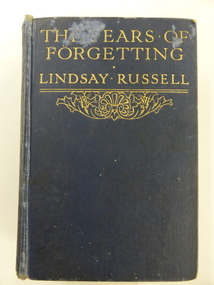
Book, The Tears of Forgetting, 1914
This is a novel written by Ethel Patricia Stonehouse under the name of Lindsay Russell. She was born in Nhill in 1883 and was educated at Charlton State School. From 1894 on she wrote verse and short stories and worked as a journalist in Melbourne. She published her first novel in Melbourne in 1912 and lived for a time in London where she met Dr John Scott whom she married in 1914. After the First World War she came to live at Mortlake and her novel writing ceased. Most of her novels are about women rebelling –against Catholicism, Calvinism, the English class system and the restraints of marriage. Her railings against the Catholic Church and the oppression of women caused her to be a controversial figure, especially in Mortlake, but she was a popular novelist with one of her books, ‘Smouldering Fires’, selling over 100,000 copies in Australia alone. She died in 1964. No details on the inscription or the recipient of the book, ‘Isie’ have been found. The name, ‘Glasgow’ suggests that the book at some stage was connected with the Glasgow family of Wangoom. They were important local dairy farmers and cheese makers in the late 19th and early 20th centuries.This book is of great interest because it was written by an Australian woman and one who lived for many years in Mortlake, a town close to Warrnambool. The connection with the Glasgow family is also of interest. This is a hard cover book of 320 pages. The book has a dark blue cover with gold lettering on the front cover and spine and some gold scroll work on the front cover. The book has a Prologue and 22 chapters and contains advertisements at the front and the back of the book for other books published by Ward, Lock & Co. There is a black and white illustration at the front of the book with a piece of tissue paper covering it. The page at the front of the book that contains an inscription is detached. The inscription and another annotation are written in black ink. The cover is partly detached from the pages and the cover is marked and worn. ‘To Isie Wishing her many happy returns of the day From Father, 15-9-14’ ‘Glasgow’ lindsay russell, ethel stonehouse, history of mortlake, australian literature, warrnambool history -
 Bendigo Historical Society Inc.
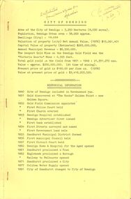
Document - ''CITY OF BENDIGO'': A DOCUMENT ''DISTRIBUTED FROM CIVIC OFFICES ON APPLICATION'' 1978
''City of Bendigo'' a document ''Distributed from Civic Offices on application'' 1978. two copies, a. and b. with different handwritten annotations. Contents - Historical Information 1840-1891; ''How Bendigo got its name''; ''Discovery of Gold''; ''Bendigo's Big Year, 1871; a history of Bendigo - in three pages; ''Education in Bendigo''; ''Information on mining in Bendigo''; Bendigo Council incl. elections, officers, revenue, ward boundaries, Mayoral Roll 1856 - 1977; Town Clerk Roll - 1856 - 1977; Town Hall details; 1891 Plebiscite; Coat of Arms details.bendigo, council, bendigo history, coat of arms, town clerk roll, mayoral roll, mining in bendigo, council elections. town hall details. -
 Bendigo Historical Society Inc.
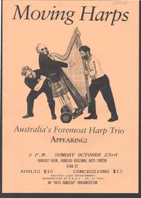
Document - MERLE HALL COLLECTION: BENDIGO PERFORMANCE OF ''MOVING HARPS'' (TRIO)
Bendigo Performance of ''Moving Harps'' (trio) - A4 and A3 flyers for performance October 1994/1995; promo sheet with information about musicians; ''sheet on 'what the critics said''; Arts Bendigo copy for Advertiser, Gazette ABC and 3CCC; newspaper ad with handwritten notation ''1995?''; newspaper cutting (Advertiser?) re concert with handwritten annotation ''8.10.94''.; fold-out coloured 'glossy' promotion sheet with coloured photo of trio with harps (to accompany CD?); Victorian Arts Council - Touring Unit 1994 AGM Showcase Artist Information Sheet. -
 Kew Historical Society Inc
Plan - Subdivision Plan, J R Mathers & McMillan, Glenferrie Road, Cotham Road, Belmont Avenue, Stirling Street, 1910-1930
Pru Sanderson, in her groundbreaking ‘City of Kew Urban Conservation Study : Volume 2 - Development History’ (1988), summarised the periods of urban development and subdivisions of land in Kew. The periods that she identified included 1845-1880, 1880-1893, 1893-1921, 1921-1933, 1933-1943, and Post-War Development. These periods were selected as they represented periods of rapid growth or decline in urban development. An obvious starting point for Sanderson’s groupings involved population growth and the associated economic cycles. These cycles also highlighted urban expansion onto land that was predominantly rural, although in other cases it represented the decline and breakup of large estates. A number of the plans in the Kew Historical Society’s collection can also be found in other collections, such as those of the State Library of Victoria and the Boroondara Library Service. A number are however unique to the collection.The Kew Historical Society collection includes almost 100 subdivision plans pertaining to suburbs of the City of Melbourne. Most of these are of Kew, Kew East or Studley Park, although a smaller number are plans of Camberwell, Deepdene, Balwyn and Hawthorn. It is believed that the majority of the plans were gifted to the Society by persons connected with the real estate firm - J. R. Mathers and McMillan, 136 Cotham Road, Kew. The Plans in the collection are rarely in pristine form, being working plans on which the agent would write notes and record lots sold and the prices of these. The subdivision plans are historically significant examples of the growth of urban Melbourne from the beginning of the 20th Century up until the 1980s. A number of the plans are double-sided and often include a photograph on the reverse. A number of the latter are by noted photographers such as J.E. Barnes.A ‘proposed’ subdivision of the area in the vicinity of Cotham and Glenferrie Roads and Belmont Avenue depicts an alternate vision for how the land might be divided into lots. When comparing this undated proposed subdivision with a modern map, it is possible to see why the subdivision did not eventuate. The right-of-way shown in the plan as beginning in Belmont Avenue was to be extended much further, preventing the lower lots from being created in the proposed shapes. Identifying the date of the name change may assist in the dating of the proposed subdivision. In faded writing at the top of the plan is an annotation referring to ‘Abbotsford’ and Finlayson’s Agency.subdivision plans - kew, glenferrie road, cotham road, belmont avenue, stirling street -
 Kew Historical Society Inc
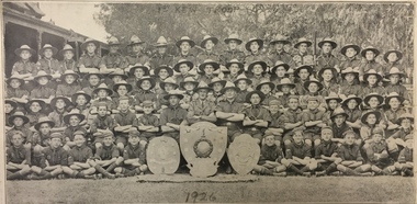
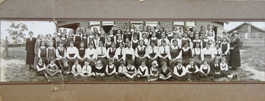
Photograph, 1st Kew Scout Group, 1st Kew Scout Troop, 1926
Group photograph of the 1st Kew Troop in uniform, with three shields. In the photo, there are seventeen Cubs (wearing caps), fifty-eight Scouts and Rover Scouts (wearing hats) and three leaders (Roy Driver ASM, R.J. Peowrie SM, Dave Evans ASM). Despite the hand annotation on the photo “1926”, it most likely celebrates the year 1925 when the Cubs won the ‘Neish Shield’, the Scouts won the ‘Cohen Shield’ and the Rover Scouts won the ‘Matthew Evans Shield’ – i.e. each section won their respective Victorian Scoutcraft competitions.Reverse: "Ron Varley, R.J. Peowrie, Roy Driver, Dave Evans"scouts - kew, 1st kew scouts, 1st kew scouts, 1st kew cubs and scouts -
![Map, Plan of Town Allotments Bacchus Marsh [1891-1897]](/media/collectors/5e461d8021ea67224c82f2a1/items/66acc1c90c778f9f64a3daec/item-media/66acc3990c778f9f64a3e09b/item-fit-380x285.jpg) Bacchus Marsh & District Historical Society
Bacchus Marsh & District Historical SocietyMap, Plan of Town Allotments Bacchus Marsh [1891-1897]
This plan of town allotments in Lerderderg Street and Bennett Street also includes the location of many of the buildings, shops, businesses and houses which were present in the retail and business area of Bacchus Marsh in the 1890s. The precise date of the plan is not known but it must be sometime between 1891 and 1897. The Post Office and the Wesleyan Church are both shown on this plan. Both of these were constructed in 1890. The plan does not show the Baptist Church in Main Street which was constructed in 1898. Hence the date is sometime between 1891 and 1897.This plan of Bacchus Marsh is one of the most detailed visual representations of the location of shops, businesses and houses in the central part of Bacchus Marsh. It provides very precise locations of most of the shops and houses in the town in the 1890s. A single page paper plan showing allotments of land fronting Lerderderg and Bennett Street. Buildings, businesses and houses along most of the streets are identified by hand written annotations. Streets identified on plan: Lerderderg Street - Bennett Street - Main Street - Gell Street - Young Street - Graham Street. Physical boundaries of the map are: North border - Lerderderg Street - South border - Main Street - West border Gell Street - East border - Young Street. The plan is pasted into a bound volume containing 76 maps or plans in total. bacchus marsh victoria maps, shops bacchus marsh -
 University of Melbourne, Burnley Campus Archives
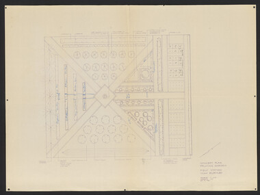
Plan, Concept Plan Pruning Garden Field Station VCAH Burnley, 1985-1995
2 sest of Concept Plans for the design of a Pruning Garden in the Field Station. (1) Pencil drawing on tracing paper, "Pruning Garden Field Station." (2) On tracing paper, "Concept Plan Pruning Garden Field Station VCAH Burnley 25.03.1995 by "JK". (3) 3 copies of (2) on paper. (4) 4 reduced size copies with some annotation. (5) Typed list, "Plants for Pruning Garden." (6) Tracing paper copy, Pruning Garden VCAH Burnley, Aug 1985. Scale 1: (7) Hard copy of (6).pruning, field station, vcah, burnley, gardens, jill kellow, experimental work on fruit trees -
Glenelg Shire Council Cultural Collection
Photograph - Photograph - Aerial Photo railway line between Heywood and Rennick, 03/05/1952
Victorian Railways aerial survey record print of the railway line between Heywood and Rennick (S.A. border) Black and white, white vertical strip on imageFront: Annotations in black and blue ink, added at a later date Back: 'Heywood - Rennick 21222 - 19503 248m 16c Heywood' - all black ink.. White sticker with 'LYONS' printed on it. '3 May 1952' - black stamp -
Glenelg Shire Council Cultural Collection
Photograph - Photograph - Aerial Photo railway line between Heywood and Rennick, 03/05/1952
Victorian Railways aerial survey record print of the railway line between Heywood and Rennick (S.A. border) Black and white, white vertical strip on imageFront: Annotations in black pencil added at a later date Back: 'Heywood - Rennick 21149 - 19430 240m 79c Heywood' - all black ink. Purple VR aerial survey stamp. '3 May 1952' - black stamp -
Glenelg Shire Council Cultural Collection
Photograph - Photograph - Aerial Photo railway line between Heywood and Rennick, 03/05/1952
Victorian Railways aerial survey record print of the railway line between Heywood and Rennick (S.A. border) Black and white, white vertical strip on imageFront: Annotations in black texta added at a later date Back: 'Heywood - Rennick 21358 - 19629 258m 23c Heywood' - all black ink. Purple VR aerial survey stamp. '3 May 1952' - black stamp -
Glenelg Shire Council Cultural Collection
Photograph - Aerial Survey Railway Record Print – 1952, 03/05/1952
Victorian Railways aerial survey record print of the railway line between Heywood and Rennick (S.A. border) Black and white, white vertical strip on image.Front: Annotations in black ink added at a later date Back: 'Heywood - Rennick 21151 - 19432 241m 14c Heywood' - all black ink. Purple VR aerial survey stamp. '3 May 1952' - black stamp -
 Robin Boyd Foundation
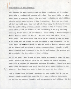
Document - Manuscript, Robin Boyd, Architecture in the Seventies
Boyd outlines the focus of the Modern Movement: function determining form and the rejection of ornamentation; outlines three phases of Modernism: the plain informal functionalist box style; 1950s monolithic sculptural forms (eg TWA terminal); and fragmented systematic expandable forms. Boyd proposes a new phase: a New Revolution Against Architecture, wherein the barriers between art and science are broken down and combined with technology; suggests looking to Japanese Metabolism.Typewritten, pencil edits, quarto, 21 pagesPage 1 refers to a chart (not attached). Sporadic annotations throughout. Appears to be a talk. Pages 6-8 refer to a chart, page 11 refers to an image of apartments by James Stirling, p14 refers to Robert Venturi's Guild House.page 1 refers to a chart (not attached). sporadic annotations throughout. appears to be a talk. pages 6-8 refer to a chart, page 11 refers to an image of apartments by james stirling, p14 refers to robert venturi's guild house -
 Beechworth RSL Sub-Branch
Postage cylinder, c. 1923
This cylinder was constructed for the postage of two documents (0060.2 and 0060.3), to notify the family of Pte James Thomas Newton (945215) 3rd Battalion, Australian Imperial Force, of his passing. The documents appear to be addressed to M A Newton, though James Thomas Newton's next of kin is listed as David Newton, his father. James Thomas enlisted on 18 July 1916, joining the 3rd battalion, first in "B" Company and . James Thomas' service records indicate that he died on 9 October 1916 in a field hospital, Liverpool, NSW. He was ailed by bronchial pneumonia for 13 days before succumbing to the illness. A telegram suggests that the family were notified on the day of his death and received the cylinder and documents in the post 6 years later. Brown card cylinder which appears to have been formed from a single sheet of card, taped in place. Paper label contains the name of the recipient, several other stamps cover the cylinder. Label reads "M A Newton/Whitfield/Vict.". Round postage stamp reads "PAID - AT - MELBOURNE VIC/ 12 MR23/8". Other stamps include "DO NOT CRUSH" and a handwritten annotation, possibly added later "BILL KELLY."post, postal, postage, death notice, certificate, private james thomas newton, 3rd battalion, australian imperial force, first world war, world was i, world war 1 -
 Bendigo Military Museum
Photograph - Visit by General to the Army Survey Regiment, Fortuna, Bendigo, c1975
This photograph was most likely taken circa 1975 in the front garden of Fortuna Villa, during an Australian Army General’s visit to the Army Survey Regiment, Bendigo circa 1975. As there are no annotations on the photo, the names of the General, the aide de camp officer and guests are unknown. LTCOL Ridge was the CO of Army Headquarters Survey Regiment from 1972 to 1973 and continued as the CO of the renamed Army Survey Regiment from 1974 to 1975. He handed over to LTCOL Peter Constantine AM, who commanded the unit from 1975 to 1976.This is a photograph taken on the occasion of an Australian Army General’s visit to the Army Survey Regiment, Bendigo circa 1975. The black and white photograph was printed on photographic paper and are part of the Army Survey Regiment’s Collection. The photographic print was scanned at 300 dpi. .1) - Photo, black & white, c1975. L to R: CO LTCOL Donald Ridge, unidentified dignitary, guests and personnel.‘Visit by Gen??? 1973-1977’ annotated on cover sheet.royal australian survey corps, rasvy, army survey regiment, army svy regt, fortuna -
Glen Eira Historical Society
Letter - Langdon Homes of Caulfield
This file contains 4 items about purchases of this book: 1/Photocopy of a typed letter dated 07/05/1986 from the National Library of Australia to Caulfield Historical Society acknowledging receipt of a copy of 'The Langdon Homes of Caulfield'. Also included in the typed receipt dated 06/05/1986 from the National Library acknowledging delivery of the copy of the book. 2/A a typed letter dated 30/04/1986 from the Royal Historical Society of Victoria to Caulfield Historical Society thanking the society for sending a copy of the book to them. 3/Typed order dated 16/10/1987 from James Bennett Library Services to Caulfield Historical Society for a copy of the book. Handwritten unattributed annotation dated 30/10/1987 noting that as out of print reply was sent. 4/A typed purchase order request from the State Library of New South Wales, dated 22/10/198,7 to Caulfield Historical Society for the book. An unattributed handwritten annotation notes that an out of print reply was sent dated 06/11/1987. Also, a typed purchase order dated 19/10/1987 accompanying the requesting letter is included.caulfield historical society, neville street, glen huntly, the langdon homes of caulfield, anderson irene v., caulfield south, ballantyne r., glenhuntly, caulfield -
Glenelg Shire Council Cultural Collection
Photograph - Aerial Survey Railway Record Print – 1952, 03/05/1952
Victorian Railways aerial survey record print of the railway line between Heywood and Rennick (S.A. border) Black and white, white vertical strip on imageFront: Annotations in red and black ink made at a later date Back: 'Heywood - Rennick 21085 - 19376 236m 9c Heywood' - all black ink. Purple VR aerial survey stamp. '3 May 1952' - black stamp -
Glenelg Shire Council Cultural Collection
Photograph - Photograph - Aerial Photo railway line between Heywood and Rennick, 03/05/1952
Victorian Railways aerial survey record print of the railway line between Heywood and Rennick (S.A. border) Black and white, white vertical strip on imageFront: annotations in red and black ink, made at a later date Back: 'Heywood - Rennick 21084 - 19375 235m 31c Heywood' - all black ink. Purple VR aerial survey stamp. '3 May 1952' - black stamp -
 Kew Historical Society Inc
Photograph - Hard rubbish in Parkhill Road
One of eight photographs donated by the City Engineer of the former City of Kew, mostly of hard rubbish clearance during the period 1969-1985.One of a dated series of photographs of core local government services as practised by the City of Kew in the period 1969-1985. Original black and white photographic positive of unburnable hard waste awaiting collection in Parkhill Road, Kew in 1969.Annotation in ink on reverse "17th Nov 1969 / 8.45a.m. / Parkhill Rd West of Adeney Ave". In envelope marked: "Kew City Council / 12 photos / 1969 1979 18980 1985 / Unburnable rubbish units 18/1/80"garbage, hard rubbish, garbage removal, city of kew, local government -- city of kew, household waste, hard waste -
 Kew Historical Society Inc
Photograph - Woodbury Ladies’ College, 1919
Woodbury College is an indirect predecessor of Preshil School in Kew. Woodbury College was founded in Glenferrie Road by a Miss Harcourt, former principal of Sydenham College, Moonee Ponds. Miss Harcourt maintained the school until the goodwill was purchased in 1908 by Miss LJ Macey, who had previously operated Lillsden Ladies' College in Edgevale Road, between c.1891 and c.1903. The first school was in a rented building on the south side of Cotham Road between Atkins and Davis Streets. In 1910, a new school building was built on the corner of Uvadale Grove and Cotham Road [the building is still extant as of 2020]. Woodbury College was operated by Miss LJ and Miss HJ Macey until 1920. In 1921, the school amalgamated with the newly formed St Andrew's College, Mont Victor Road, Kew (Vic) under the leadership of Rev JT Lawton [who had previously been principal of St Andrew's School of the 'Pathfinder' in South Yarra]. Miss Macey was for a period the Headmistress of the amalgamated school. Another teacher at the school was Miss Margaret JR Lyttle, who in 1931, left St Andrew's to form the Preshil School.A rare panoramic photograph of Woodbury College in Kew, Victoria. The photograph is part of a large collection of original manuscripts and ephemera relating to the school.Panoramic photograph of the students and teachers of Woodbury College, Cotham Road (Kew). Students identified in the photograph include: Back Row, 5th from left Betty Paton; 4th from right - Jean Strickey (sic).Annotation to reverse: "Woodbury College (Miss L.J. Massey) established Cotham Rd Kew. Est. at this venue 1908. Later joined by Rev. J.T. Lawton & formed a school in Mount Victor Rd Kew St Andrew’s College in 1921.’ woodbury college, cotham road (kew), education, schools, kew, l.j. massey, j.t. lawton, st andrew's college -
 Kew Historical Society Inc
Photograph, C.S. Tompkins (Ainar Studios), Kew Council Cricket Team, 1922-1924
Historically significant and rare photograph of Kew Councillors playing in a Cricket Team in the early 1920s.Kew Council Cricket Team. The City of Kew at times had its own cricket team. Identified players of the 1922-23 team include: Back row, left to right: Cr. Coleman, Cr. Edwards, Staff, Staff, Cr. Barnard, Mr Birrell, Cr. Wishart. Front row, left to right: Cr. Ramsey, Cr. Woolcock (Mayor), C. Cole, and Cr. Carnegie. Of the eight councillors in the team, each either had been or would be Mayors of Kew: William Wishart (1906-07), Jabez Carnegie (1908-09, 1924-25, 1934-35), Francis Barnard (1920-21), Henry Coleman (1921-22, 1929-30), James Woolcock (1922-23, 1923-24), George Ramsey (1925-26), George Cole (1926-27), and Percy Edwards (1928-29). W. D. Birrell became Town Clerk of Kew in 1938. The photographic studio's name at front is identified as C.S. Tompkins Ainar Studios, Auburn. Annotation on reverse include the names of the players, an original accession number "KH-22" and information about donor "Presented by Joy Stewart, given to her by the Edward[s] family, Mr Edward[s] once Mayor of Kew (1928-29)city of kew, kew councillors and staff, sports -- cricket -- kew (vic.) -
 Bendigo Historical Society Inc.
Photograph - CORNISH COLLECTION: PHOTOGRAPHS OF CHURCH BUILDINGS WITH CORNISH CONNECTIONS, 1900
Collection of photographs of various Bendigo church buildings with Cornish connections: a. front of simple (Methodist) wooden church with handwritten annotation of ''Webster St'' together with typewritten attachment to photo giving some of history of Methodism and the Cornish (and the four sects represented in Bendigo); b. Photo of interior of Chapel Street Gospel Hall (Mission Hall) decorated for Sunday School Anniversary (no date); c. three photos - Former Wesleyan Church, Kangaroo Flat; the former Primitive Methodist Church, Eaglehawk; former Bible Christian Church , California Gully (''now St Judes Anglican'' - typewritten attachment to photo).photograph, building, church, john wesley. united methodist free church. wesleyan mission hall. bible christian church. uniting church. -
Southern Sherbrooke Historical Society Inc.
Information folder - Fires 2003, 2003
Folder containing information pertaining to the 2003 Victorian, NSW & ACT bushfires. Contents: -3 photos of Omeo after the fires, by Dulcie Strahan -DSE/DPI Fire Update report dated 21st February -2 photos of fires in North-east Victoria by Andrew Aubert -3 Fire Overview maps, dated 24 January, 27 January (2 copies) and 16 February -leaflet, "Upper Murray Fires", community update, dated 12 January -copy of fire overview map, dated 16 February, with annotations -weather page, Border Mail, 8 Januarybushfires -
 Kew Historical Society Inc
Plan - Subdivision Plan, Tregarron Estate, Kew, c.1929
Pru Sanderson, in her groundbreaking ‘City of Kew Urban Conservation Study : Volume 2 - Development History’ (1988), summarised the periods of urban development and subdivisions of land in Kew. The periods that she identified included 1845-1880, 1880-1893, 1893-1921, 1921-1933, 1933-1943, and Post-War Development. These periods were selected as they represented periods of rapid growth or decline in urban development. An obvious starting point for Sanderson’s groupings involved population growth and the associated economic cycles. These cycles also highlighted urban expansion onto land that was predominantly rural, although in other cases it represented the decline and breakup of large estates. A number of the plans in the Kew Historical Society’s collection can also be found in other collections, such as those of the State Library of Victoria and the Boroondara Library Service. A number are however unique to the collection.Subdivision plans are historically important documents used as evidence of the growth of suburbs in Australia. They frequently provide information about when the land was sold on which a built structure was subsequently constructed as well as evidence relating to surveyors and real estate and financial agents. The numerous subdivision plans in the Kew Historical Society's collection represent working documents, ranging from the initial sketches made in planning a subdivision to printed plans on which auctioneers or agents listed the prices for which individual lots were sold. In a number of cases, the reverse of a subdivision plan in the collection includes a photograph of a house that was also for sale by the agent. These photographs provide significant heritage information relating house design and decoration, fencing and household gardens.In January 1929, the Kew City Council called for tenders to construct Tregarron Avenue. The subdivision of the Tregarron Estate in Kew was for 11 lots bordering Tregarron Avenue and its entrance from Burke Road. The plan includes annotations that indicate the measurement of each block and the placement of the drainage and sewerage easements. This plan is interesting for a number of factors. The house blocks today have different street numbers, some blocks were to be further subdivided, and at the time of the subdivision, alterations were still being made to the extent of lots offered; lots 2 and 3 on the plan were subdivided and reoriented.subdivision plans - kew, tregarron estate, tregarron avenue -- kew (vic.), burke road -- kew (vic.) -
Glen Eira Historical Society
Photograph - Caulfield, John
Four photos, photocopies relating to John Caulfield, died 21/06/1879. Two photocopies of two photographs of Caulfield Hall, with instructions on how to get there by public transport. Penciled annotations on reverse “John Phillip Thomas Caulfield, Died 1907 #1525; contact Anne Caulfield 5678 0273”. Photocopy of photograph of John Caulfield with caption “Builder John Caulfield, died 21 June 1879”. Photograph, inscribed on back “No 13 Church photograph, John Caulfield, Latrobe Library” It includes eight other discernible men’s photos with the one large photograph.caulfield john, caulfield hall, alma road, hotham street, east st kilda, mansions, architectural features, builders -
Kew Historical Society Inc
Equipment, Handheld Directional Compass, 1960s
This work forms part of the collection assembled by the historian Dorothy Rogers, that was donated to the Kew Historical Society by her son John Rogers in 2015. The manuscripts, photographs, maps, and documents were sourced by her from both family and local collections or produced as references for her print publications. Many were directly used by Rogers in writing ‘Lovely Old Homes of Kew’ (1961) and 'A History of Kew' (1973), or the numerous articles on local history that she produced for suburban newspapers. Most of the photographs in the collection include detailed annotations in her hand.The Rogers Collection provides a comprehensive insight into the working habits of a historian in the 1960s and 1970s. Together it forms the largest privately-donated collection within the archives of the Kew Historical Society.Circular compass, marked by degree to 360. Metal case with cracked glass upper surface. Metal ? with brass pivot. North marked by an exterior metal knobInterior labelled with N,S,E, and W in large print. NW, NE, SE and SW in smaller print. Outer circle marks the degrees, notated in 20 degree steps Numbered KH311compass, handheld compass, dorothy rogers