Showing 1101 items
matching information map
-
 Southern Sherbrooke Historical Society Inc.
Information folder
Information folder pertaining to Birdsland. Contents:/map (copy), Shire of Yarra Ranges, Birdsland Reserve/flyer, Birdsland Then and Now, advertising talk at Belgrave Library, 9 Oct 2014birdsland -
 Southern Sherbrooke Historical Society Inc.
Information folder - Lovers Walk, Belgrave
Folder containing information pertaining to the history of Lovers Walk. Contents: -5 maps showing Rights-Of_way between Belgrave and Mt Morton, Belgrave Heights, with path of Lovers Walk indicated -2 photos, reprints of Rose postcards, showing views of Lovers Walklovers walk, mt morton, walking tracks -
Southern Sherbrooke Historical Society Inc.
Information Folder - geology of Dandenong Ranges
Information folder containing items pertaining to the geology of the Dandenong Ranges, including material prepared by Betty Hotchin for a talk to the Kallista Tourism course. Contents:-/typescript, re. basic features/photocopy, "The Dandenongs volcano and settlement in its great forest" by John Lundy-Clarke, published by Lilydale and District Historical Society/2 maps, Dandenong Ranges/List of reference materialdandenong ranges, geology of dandenong ranges -
Southern Sherbrooke Historical Society Inc.
Information folder - Germans Gully - Arcady
Folder containing items pertaining to the history of Germans Gully - Arcady, Belgrave Heights. Contents: -4 colour photos, c. 2000, showing house and gardens -sketches, photocopied, by Barbara Smith, dated 29 October 2002, showing stone huts at Arcady prior to mid-1950s, with additional comments by Marian Matta -typescript, "Short History Of Arcady also known as German Gully, 'Carinya' & Church Of Freedom", 1 page, 3 copies including one with small photo -typescript, dated 22 June 97, "Plarre Visit to 'Arcady', Originally Known as 'Carinya'", six pages -hand-written letter, addressed to "Sue & Peter" (Downard) from Ralph (Wilson) dated April 02, containing historical information re. Arcady, 4 sheets double-sided -Yarra Ranges Shire Heritage Study Place Nomination Form for Germans Gully, partially completed -obituary, Herald Sun newspaper, undated but 2003, "Raymond Otto Plarre, Baker had passion for quality produce" -4 page Fairfax newspaper wraparound, "A Recipe For Success", advertising feature commemorating Ferguson Plarre Bakehouse Centenary, 1901-2001 -8 sheets of photocopied photos of Arcady, taken during Plarre ownership -Certificate Of Title (number illegible) dated 10 July 1919, initial purchasers being Robert and Bertha Maurer, 3 copies of obverse sheet (copies) (dups. in A3 folio #1) -Certificate of Title, Vol. 5262, Folio 1052392, dated 18 January 1927, initial purchaser being Bernhard Walk (2 copies, one issued 12 Aug 1996, one issued 17 Apr 1997) (dups. in A3 folio #1) -photo (colour) and hand-drawn map of site, prepared by Ralph Wilson, 2006 -Pamphlet, "Our Place, a celebration of where we live", Shire of Yarra Ranges, Oct. 2006 -photos (2, colour) of fire at Arcady, annotated 'Hello Peter & Sue, more pictures taken by Marty of CFA' -article, Australian Post, 6 Jul. 1972, 'Fool around with SCARLETT!', 2 photos of John Wilson (in A3 folio #1)albert hartung, otto plarre, mr stace, john wilson, count felix von lucknor, mr & mrs smart, plarre family, mr hutter, carinya, raymond otto plarre, ferguson plarre bakehouses, keith cooke, hugh ackland, alexander wynnum king, russell & jean smart -
Southern Sherbrooke Historical Society Inc.
Information folder - Auxilium College
Folder containing items pertaining to history of Auxilium College, Lysterfield. Contents: -"Tarella Quin" - article by Margaret McInnes, photocopy of Knox Historian Vol. 4 No.1 May 1992, pp. 42-65 -"Salesian serenity" - article by Scott Spits, photocopy of Knox News, Dec. 1, 1998, pg. 9 -"Auxilium College formerly known as Leasowes", information sheet prepared for Southern Sherbrooke H.S. Heritage Week tour, April 2002 -"Map to get from Auxiliun College to Mount Heatherley", map prepared for tour -article. "The Life & Works Of Tarella Quin". Knox Historical Journal, 2006 -photos, eleven, taken during our tour -
Southern Sherbrooke Historical Society Inc.
Information folder - Elvery family
Folder contains information pertaining to the Elvery family of Belgrave Heights. Contents: -Trifold A3 pamphlet, glossy paper, black, white and orange "The Lodge Just the perfect place to stay" c1990s advertisement flyer. -Map, hand-drawn with photos attached, "9 Hole Golf Course. Belgrave Heights - 1930-1943". Photocopy of large poster made by Betty DeCoite (original in map drawer) -Photocopy of photo, annotated in ink "Photo taken in Dandenongs - possibly Monbulk/the Patch? Photo supplied by David Elvery 2/6/99" -Photocopy of photo, Belgrave South Football Club team, probably 1945, plus list of names of team - from David Elvery 2/6/99 -printout, State Library of Victoria Multimedia Catalogue, Rose Series postcard of "Sunnyside Lodge" Lockwood, Belgrave South -copy of printed letter from David Elvery to CEO Shire of Yarra (sic) dated 8/6/99 re. vegetation on Mt Morton. Handwritten additions plus p'copy of Valentine Series postcard #3832 "Panorama From Mount Morton, Belgrave Heights" -p'copy of typed speech with annotations, by Rev. A.C. Beckingham at the opening of Lockwood -p'copy of photo, Harrison and Dalny Elvery and children David and Wendy c1936. Annotated by David Elvery 30/5/99 -printout, SLV Multimedia Catalogue, Rose Series postcard "Lockwood House" Lockwood, Belgrave South -p'copy, subdivision map "Lockwood Estate" lodged plan 6548 -p'copy, subdivision map Lockwood area, plan #6970 -A3 sheet, p'copies 6 postcards of Belgrave Heights -p'copy photo Elvery house, later "Sunnyside" and "Devon Lodge" annotated by David Elvery 2/6/99 -3 p'copied photos, Belgrave Heights, possibly Varney's butchers shop, possibly Whitlam residence. Annotated by David Elvery -2 p'copied photos, "Lockwood House", Golf links (Bill Woodfull, Principal of Upwey High School in photo), annotated David Elvery 2/6/99 -2 photos from David Elvery - moving Melbourne tram into "house" location at Lockwood, and bus "W. Dyke" unknown date and location. -3 photos from David Elvery - David on Gypsy (pony) Mt Morton Rd c1937, Wendy and David at entrance 37 Lockwood Rd c1942, David on Mack (horse) on golf links c1947 -Photo Arthur and Harrison Elvery, Lockwood House in background c1916 -photo Mrs Elvery, p'copy of postcard 26/3/20 addressed to "Dear Maud", mentions Charlie's wife and Laura (incomplete) -photo George Rae (Narre Warren North) Harold Allen and three other boys c1939 -6 photos, unlabelled (duplicates?) -photo Orchard Rd, Belgrave Heights -photo unlabelled, woman with child in pram, house in background (Lockwood?) -photo David Elvery on Gypsy as above -Rose postcard P2032 "Lockwood" Belgrave, Victoria -photo David Elvery on Mack (as above) -photo Wendy and David Elvery (as above) -2 photos, tram being moved (as above), football team -p'copy of Certificate of Title Vol.4562 Fol. 912336 dated 31/1/1922 - see list of names in folder -p'copy Memorial of Instruments (Land Title) dated 14/1/1914 -p'copy Cert. of Title Vol. 4562 Fol. 912335 dated 31/1/1922 -handwritten note, David Elvery to Susan Heywood-Downard -p'copy Memorial of Instruments dated 14/1/1914 -p'copy subdivision map, area bounded by Glen, Orchard, Avonside and Bay Rds, Belgrave Heights -p'copy Cert. of Title, Vol. 4810 Fol. 961945, dated 2/1/1924 -p'copy Cert. of Title, Vol. 4562 Fol. 912337, dated 31/1/1922 -Typed list of photo caption, relating to some of above photos -List of names and dates appearing on land title documents enclosed -Printout, Australian Dictionary Of Biography - Davies family - handwritten addition, marriage details, Arthur Elvery & Hannah Ord. -Printout - Family Search, Maria Louisa Davies, and family group, Ebenezer Davies & Ruth Bartlett. -letter to editor, Northern Star, Lismore, NSW, 11 Aug. 1923, Hannah Elvery, re. sport on Sunday -typescript - Elvery Family History, part of the "Alstonville" Elvery story, supplied by David H. Elvery 30th May 1999. From Bob Quincey.elvery family, lockwood house, belgrave heights, devon lodge -
Southern Sherbrooke Historical Society Inc.
Information folder - Local Government Amalgamations 1986, 1985 & 1986
Folder containing information pertaining to the Local Government amalgamations in Victoria in 1986. Contents: -copy of "Local Government Act 1958, appointment of a division of the local government commission and referral of proposals to the division", 8 pages and 6 explanatory maps -memo, dated 21 November 1985 from K. E. Matson, General Manager, Shire of Sherbrooke, to all councillors, re. local government commission and municipal restructure, 12 pages including map -letter, Warwick Heine, CEO, Shire of Lilydale to K. E. Matson, General Manager, Shire of Sherbrooke, dated 16 April 1986, re. local government restructure (2 copies) -booklet, "The Restructure of Local Government in Victoria: Options Paper Eastern Melbourne Segment", Local Government Commission June 1986, 24 pages -article "Residents to fight land deal", Knox-Sherbrooke News, 17 June1986, re. proposed annexation of part of Lysterfield by Berwick Council -article "Knox and Sherbooke align for the future", The Trader, 30 April 1986, re. alignment of common boundary -article "Boundary changes 'just a joke'", by Cheryl Critchley, Knox-Sherbrooke News, 6 May 1986 , re. Knox-Sherbrooke boundary alignment -article "Border clash worsens", by Peter Janky, Mountain District Free Press, 7 May 1986, re. Sherbrooke-Lilydale boundary changes -article "Ranges future is still clouded", The Free Press 30 April 1986, re. proposal to form a shire covering Dandenong Ranges -article "Sherbrooke wins first battle in restructuring", by Peter Janky, Free Press, 30 April 1986, re. ceding of forest areas by Knox to Sherbrooke.shire of sherbrooke, shire of lilydale, knox city council, berwick shire council -
Southern Sherbrooke Historical Society Inc.
Information folder - Fires 2003, 2003
Folder containing information pertaining to the 2003 Victorian, NSW & ACT bushfires. Contents: -3 photos of Omeo after the fires, by Dulcie Strahan -DSE/DPI Fire Update report dated 21st February -2 photos of fires in North-east Victoria by Andrew Aubert -3 Fire Overview maps, dated 24 January, 27 January (2 copies) and 16 February -leaflet, "Upper Murray Fires", community update, dated 12 January -copy of fire overview map, dated 16 February, with annotations -weather page, Border Mail, 8 Januarybushfires -
 Southern Sherbrooke Historical Society Inc.
Information folder - Madigan Cottage
The buildings are probably rare remnant examples of their type in the local area and as such are significant to the settlement of Menzies Creek. The dwelling is significant as a longstanding marker of the Madigan family who were original settlers in the area. Its retention in its site close to the road boundary expresses and maintains a connection with early settlement and rural lifestyles in Menzies Creek over the last century. The old shed is of interest as a local example of bush construction, particularly in context with the cottage and farm environs. Without the life of the farm and other elements presumed now gone, its value is lessened.Folder containing information pertaining to the history of Madigan Cottage, Menzies Creek. NB: the shed was demolished in November 2001 and the cottage burned down sometime later. Contents:- Letter, Southern Sherbrooke Historical Society to Shire of Yarra Ranges, dated 9th March 2001, re. sale of property and need for it to be included in shire's Heritage Study. -Letter, shire to society, dated 20th March 2001, reply to above. -Letter, shire to society, dated 15th May 2001, follow-up to above, requesting more information. -Letter, society to shire, dated 30th May 2001, responding to above and including a copy of information previously sent to Chris Johnston, Heritage Study consultant. -Letter, society to shire, undated, noting intention to lodge an objection to proposed application for development on site. -Letter, shire to society, dated 22nd October 2001, advising of consultation meeting. -Yarra Ranges Shire Heritage Study Place Nomination form for Madigan Cottage, prepared by Marian Matta, includes nine colour photos and diagram showing where photos were taken from. -Black and white copies of photos. -A3 copy of real estate advertisement, "Mount Evergreen Estate" dated 21st April 1924. -A3 map showing proposed resubdivision boundary variation, drawn up for Mr. P. Melville, undated but 1990s. -Copy of application for a planning permit, dated 6th August 2001, including letter by Nick Jonkers describing proposed new buildings, site map showing current vegetation, letter re. proposed removal of vegetation, subdivision plan dated March 1998, and larger scale map printed from shire website on 10th August 2001. -5 A3 sheets showing site and house plans drawn up for Mr & Mrs N. Jonkers, dated July 2001.madigan cottage, menzies creek, madigan family, mount evergreen, patrick madigan -
Southern Sherbrooke Historical Society Inc.
Information Folder - Len Jeffery
Information folder containing items pertaining to Len Jeffery. Contents: -handwritten notes by Elaine Cordell, dated 2017 -letter, Peter & Ruth Jeffery, to Phil Garland, dated 25 June 2011 -letter, Peter & June Jeffery to Elaine Cordell, dated 26 July 2011 -photocopy, A4, of photo featuring Thomas & Henry Jeffery -photocopies of death notice and short obituary, undated -photocopies (2), parish map (part) -photocopy part of allotments in Parish of Narree Worran with attached newspaper clipping -photocopy of hand-drawn map of blocks in Belgrave Heights -magazine "Yarra Valley & Ranges country life", Issue 7 Winter 2011, featuring article about Peter Jeffery, Len Jeffery's nephewlennox jeffrey, peter jeffery, belgrave heights progress association -
 Royal District Nursing Service (now known as Bolton Clarke)
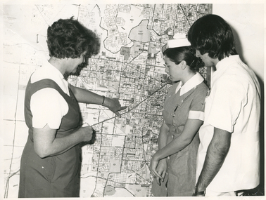
Photograph - Photograph, black and white, Barry Sutton, 01.05.1974
Sister Ellen Anderson is the Supervisor of the Royal District Nursing Service, (RDNS) Footscray Centre. She is wearing her RDNS uniform of a short sleeve white blouse under a royal blue V neck tunic style dress. Sr. Anderson is showing two Student nurses from Western General Hospital the map with the areas covered by Footscray Centre. The map had different colour pins to identify streets where patients lived who were currently receiving nursing care from RDNS Sisters working in these areas (districts).During their training, Student nurses from several hospitals either attended the Royal District Nursing Service (RDNS), Education Department, or, a RDNS Nurse Educator travelled to the appropriate hospital’s Education Department to educate the Trainees on District nursing through the RDNS Community Nursing Program. Following the lectures Students went to a RDNS Centre and each Student accompanied a Trained nurse (Sister) for a week observing and gaining knowledge of all facets of nursing care in the home. This gave them an insight into the home conditions and situations patients faced after discharge from hospital. During 1971 there were 584 Student nurses who received field experience with RDNS. From its inception as Melbourne District Nursing Society (MDNS), in 1885, their Trained nurses (Nurses) worked in specific areas, 'districts'. The first Nurse worked east and west, between Victoria Parade and Flinders Street and, north and south, between Spencer Street and Spring Street. When a second Nurse was employed they divided this area at Elizabeth Street so each Nurse could attend to patients in the same area giving continuity of care. As the Society expanded, becoming Melbourne District Nursing Service, then, with Royal patronage, Royal District Nursing Service (RDNS) many Centres were opened throughout the Melbourne Metropolitan area and outer suburbs. The District nurse's areas (districts) grew and were divided within Shire boundaries for e.g. Knox 1, Knox 2, Knox 3, Knox 4, within the area of the Shire of Knox. A map covering the Centre’s Districts was attached to a wall, and its different colour pins identified streets where patients lived who were currently receiving nursing care from the RDNS Trained nurses (Sisters) working in these areas (districts).On the left of this black and white photograph is Royal District Nursing Service (RDNS), Sister Ellen Anderson, who has short dark curly hair and is wearing her RDNS uniform of a short sleeve white blouse under a dark V neck tunic style frock. She is standing side-on, towards the right of the photograph, and with her left hand is pointing to an area on a large map attached to the wall in the background. To her right, is a Student nurse who is facing Sr. Anderson, and looking at the area on the map. Under her white nurses cap, she has her long dark hair drawn back, and is wearing her hospital uniform of a short sleeve checked dress with white collar and cuffs; a nursing watch is attached to its upper left; her hands are clasped in front of her. To her right, is a male Student nurse who has collar length straight dark hair, and is wearing white trousers and a short sleeve white top with pens in the left upper pocket. He is looking at the areas on the map.. Barry Sutton MA 77 informationroyal district nursing service, rdns, rdns education, rdns centre, rdns district map, sister ellen anderson -
Moorabbin Air Museum
Booklet - Information and Route Maps System of the Golden Jets, Ansett
... Moorabbin melbourne Ansett Booklet Information and Route Maps System ... -
 Ballarat Tramway Museum
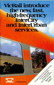
Ephemera - Timetable, Victorian Railways, VicRail timetable Spring 1981, Oct. 1981
.1 - Timetable - 92 page + cover with fold out map, centre stapled. Printed at the time of the introduction of new rolling stock and faster services, both Intercity and Regional. Dated Spring 1981. Shows train services to Ballarat at the time and for the VicRail. Relevant pages including fares and a map have been scanned. .2 - "Fares" - 16 page centre stapled book providing fare information - dated 4/10/1981. .3 - Pocket Timetable - Melbourne Ballarat 22/8/1993 .4 - ditto 16/10/1994 - both .3 and .4 advertise Sorbothan insoles for shoes. See Reg Items 6824, 8116, 8117 and for 1998, 1957, 1981,1993 and 1994 and 2021 respectively.ballarat, railways, vicrail, timetables, fares -
 Ballarat Tramway Museum
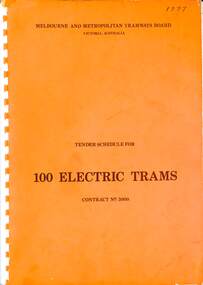
Document, Melbourne and Metropolitan Tramways Board (MMTB), "Tender Schedule for 100 Electric Trams Contract No. 3000", 1977
Compiled and published by the Melbourne and Metropolitan Tramways Board, closing Monday 10 May 1977. Details the conditions of tender, conditions of contract, notes, specifications, gives background information about Melbourne, dimensions, performance, drivers and conductors, trucks, wheels, brakes, electrical equipment, control panels and drawings. The drawings give a map of the system, typical city route, Glenferrie Road route (grade diagram), concrete track construction, min. radius curves, loading gauge, all-electric tram and mounting details for the trolley base, schedule of prices, tender form, form of contract, and schedule of information to be provided by the tenderer. Includes an Alphabetical Index. Includes a drawing for a single-ended version of the tramcar. Became the Z3 class following the addition of a rear or 3rd door. Yields information about the 1977 tender for 100 electric tramcars that became the Melbourne Z3 class tram.Comb bound (white plastic) specification or tender document, approx 180 pages, with glossy card orange covers, titled "Tender Schedule for Electric Trams" and "Contract 3000". "1977" on front cover in ink.tramways, tramcars, z3 class, specification, tenders, mmtb, melbourne, single ended tramcars -
 Ballarat Tramway Museum
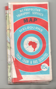
Map, Ministry of Transport, "Melbourne Transport Services Map - Tram, Train and Bus Services", 1974
... Parade Ballarat Ballarat goldfields Coloured map of Melbourne's ...Coloured map of Melbourne's Tram and Bus routes, route numbers, rail lines, detailed for the central part of Melbourne and insert section for Frankston. On rear description of routes, private bus routes and map of Melbourne metro lines. Has contact details for bookings and lost property etc. Priced 15c. Inscription dates the map as 1974. Yields information about public transport services in Melbourne as a comparison with that of Ballarat.Fold out map (27 sections 9 across x 3 deep), printed on paper.trams, tramways, railways, melbourne, map, tram and bus services, mmtb, minister for transport, public transport -
 Ballarat Tramway Museum
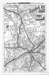
Map, Broadbent's, "Broadbent's Map 193 Bendigo", 1950s
Map of Bendigo showing streets, with the tram routes in dotted lines. Has a legend, scale and continuation maps. Gives an address of 475 Collins St Melbourne and a Melbourne telephone number - MR 2021.Yields information about Bendigo and its tram lines. Broadbents was a prolific publisher of maps. Map - single sided card, pocket map priced at 1/- - undated.bendigo, tramways, tram lines, maps, broadbents -
 Ballarat Tramway Museum
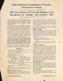
Poster, State Electricity Commission of Victoria (SECV), "The New System of Fares and Sections to be Introduced on Sunday, 3rd October 1937", Sep. 1937
Poster titled "The New System of Fares and Sections to be Introduced on Sunday, 3rd October 1937" produced by the SECV, Ballarat Electric Tramways. r. Provides information on the SEC control, the method of payment, sections, fares, weekly, school, scholars, luggage and parcel, View Point Services and Tourist Ticket. Signed by H. N. Hornabrook as Manager. Has printer's name, Tulloch and King in the bottom left-hand corner. See Reg. Item 2488, page 30 for another copy 8251 for the associated map/fare poster that was used in tramcars.Demonstrates the work the SEC undertook to provide information on the new ticket system of 1937 and yields information about the system.Poster quarto typeset printed sheet, Printed in blue ink on white paper with a semi gloss. Three copies held.trams, tramways, sec, fares, sections, tickets -
 Ballarat Tramway Museum
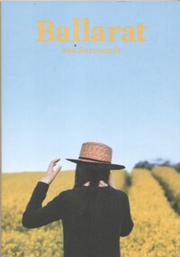
Book, The Ballarat Visitor Information Centre, "Ballarat and Surrounds", 2017
Full colour, 120 page, book, A5 size titled "Ballarat and Surrounds" with a cover photo of yellow fields. Gives details, maps accommodation listing, attractions etc of the Ballarat area. Page 46 details the Ballarat Tramway Museum. Inside rear cover is a fold out map of the district, city centre, Buninyong and Mt Helen and Ballarat and Surrounds. Published 2017 by The Ballarat Visitor Information Centre. trams, tramways, ballarat, visitors, tourist guides, btm, gardens -
 Ballarat Tramway Museum
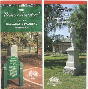
Pamphlet, Friends of the Botanical Gardens, "Ballarat Botanical Gardens", 2016 - 2018
Set of four DL size pamphlets giving details of specific areas of the Ballarat Botanic Gardens, published by the Friends of the Ballarat Botanical Gardens and the POW Memorial Trustees. .1 - The Prime Ministers' at the Ballarat Botanical Gardens - giving details of the Prime Ministers busts and their short history, the sculptors, the history of the avenue. .2 - Statues of the Ballarat Botanical Gardens - 4 fold DL - includes a list and a map of the various statues and conservation issues. .3 - Friends of the Ballarat Botanical Gardens - 2 fold DL - information and membership application form along with contact information. .4- The Australian Ex-Prisoners of War Memorial - 3 fold DL - giving details of the war memorial and contact information.trams, tramways, gardens, botanical gardens, prime ministers avenue, statues, ex prisoner of war memorial -
 Ballarat Tramway Museum
Map, Electric Supply Co. of Vic (ESCo), Ballarat Electoral Map - ESCo, 1900
Document prepared by the Electric Supply Co of Victoria, as part of an order under the Electric Light and Power Act 1896, section 5 of order No. 17 granted to company. Dated 19/2/1901 and signed by the Postmaster-General. Shows the order area being parts of the City of Ballaarat, Sebastopol and Ballarat East. Shows the street names, boundaries, principal power line routes, land reserves, parks, mine locations, railways and Lake Wendouree. Signed by R L Williams Town Clerk City of Ballarat, J R Hall for the Borough of Sebastopol, and John Gent for the Town of Ballarat EastYields information about the power supply to the Ballarat area.Cloth backed paper map, coloured and marked up as exhibit 17.Notes in ink including the signature of Benjamin Deakin 24/9/00 and certified by the three involved municipal Town Clerks.ballarat power supply, esco, electric supply co of victoria, city of ballaarat, east ballarat, sebastopol, orders, power lines, power supply -
 Ballarat Tramway Museum
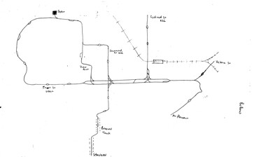
Map, Ballarat and Bendigo tram systems, 1960's or 1970's
Yields information about the extent of the Ballarat and Bendigo tramway systems and possibly has a strong association with the work of Tom Murray.Set of two hand drawn maps of the Ballarat and Bendigo tram systems, showing loops, terminus, depots and rail lines, including out of use loops and reserved track. Possibly made during the 1960's or early 1970's. Drawn on lined foolscap paper - have been torn from a pad.trams, tramways, map, drawings, ballarat, bendigo -
 Ballarat Tramway Museum
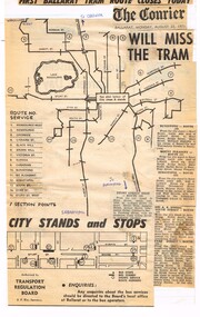
Newspaper, The Courier Ballarat, "First Ballarat Tram Route closes Today", Aug. 1971
Yields information about the extent of the Ballarat bus services that replaced the tram services in 1971 and their extent.Newspaper cuttings, composite, glued to a ruled or line foolscap sheet with the heading ""First Ballarat Tram Route closes Today", the Courier banner Monday 23/8/1971 (the day after the actual first closure) and a map or advertisement authorised by the Transport Regulation Board of the Ballarat bus routes, details, section points and detailed description of six routes. Would appear to have been compiled from at least two issues of The Courier, possibly by Tom Murray.ballarat, buses, bus routes, map -
 Ballarat Tramway Museum
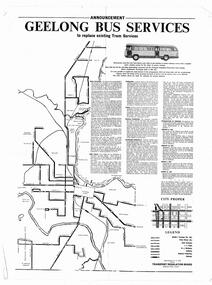
Poster, Transport Regulation Board, "Geelong Bus Services", late 1955
Yields information about the closure of the Geelong Tramway system and the bus replacements made by the Transport Regulation Board, can be compared to that for Ballarat.Poster printed on off white paper with a gloss finish on the printed side - Produced shortly before the closure of the State Electricity Commission of Victoria operated Geelong Tramway system. Gives details of the replacement bus services as well as the existing bus services and other changes planned. Provides notes on the operator, timetables, fares, vehicle standards and dates when the services would be changed. Map shows Operator, section points, rail lies and service levels. Authorised by the Secretary of the Transport Regulation Board E V N Field. pdf file has to be opened outside dbTextWorks.trams, tramways, geelong, closure, map, buses -
 Ballarat Tramway Museum
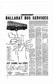
Poster, Transport Regulation Board, Ballarat Bus Services", Aug. 1971
Yields information about the closure of the Ballarat Tramway system and the bus replacements made by the Transport Regulation Board, can be compared to that for Bendigo and Geelong.Poster, titled "Ballarat Bus Services" printed on off white gloss paper. Produced shortly before the closure of the State Electricity Commission of Victoria operated Ballarat Tramway system. Gives details of the replacement bus services as well as the existing bus services and other changes planned. Provides notes on the operator, timetables, fares, route numbers and dates when the services would be changed. Map shows the bus routes, route numbers, section points and City stands and stops. Authorised by the Secretary of the Transport Regulation Board B. P. Kay. pdf file has to be opened outside dbTextWorks.trams, tramways, ballarat, map, closure, buses -
 Ballarat Tramway Museum
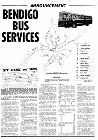
Poster, Transport Regulation Board, Bendigo Bus Services", Feb. 1972
Yields information about the closure of the Bendigo Tramway system and the bus replacements made by the Transport Regulation Board, can be compared to that for BallaratDigital print of a scanned Poster, titled "Bendigo Bus Services" printed on white paper. Produced shortly before the closure of the State Electricity Commission of Victoria operated Bendigo Tramway system. Gives details of the replacement bus services as well as the existing bus services and other changes planned. Provides notes on the operator, timetables, fares, route numbers and dates when the services would be changed. Map shows the bus routes, route numbers, section points and City stands and stops. Authorised by the Transport Regulation Board. trams, tramways, bendigo, map, closure, buses -
 Ballarat Tramway Museum
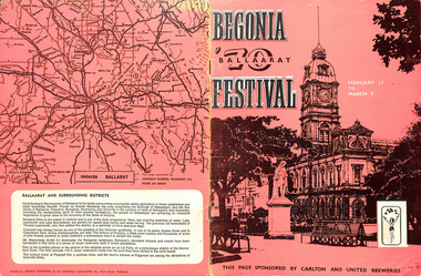
Programme, Ballarat Begonia Festival, "Ballaarat 70 Begonia Festival", Feb. 1970
Yields information about the City of Ballarat and its involvement in the promotion of the city through the Begonia Festival. Yields information about the tramway through a map.Programme or book, 16 Quarto pages, centre stapled full colour on semi gloss paper, titled "Ballaarat 70 Begonia Festival" for the 1970 Begonia Festival. 27/2/1970 to 9/3/1970. Gives details of the city, the begonias, industry, how to grow them, Festival activities, agriculture, map showing the city roads, a suggested tour route, tram lines, Eureka stockade, Historical Park (Sovereign Hill), 3BA, The Courier, BTV6, Education and sporting facilities. Really a City spruiking document with many colour photos. Note all words with Ballarat in them are spelt with the aatrams, tramways, begonia festival, ballarat, map -
 Ballarat Tramway Museum
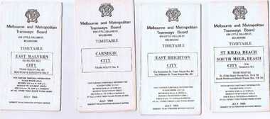
Ephemera - Timetable/s, Melbourne and Metropolitan Tramways Board (MMTB), Set of 24 MMTB Melbourne tram timetables, 1969
Set of 24 MMTB timetables for various routes, dated July 1969. Generally includes Sat and Suns, Good Friday and Christmas day as well as weekdays, unless noted otherwise. Also includes a map of the route, detailed time points, sections, connecting services, fares, and organisation address - 616 Little Collins St. Melbourne. Have been folded into ten portions. All on white paper unless noted otherwise. Items shown with an # - have a sticker modifying timetable information details on the front page. 1154.1 - Route 4 - Carnegie - City .2 - Route 4D - East Malvern (Darling Road) - City # .3 - Route 5 - Malvern Burk Road, - City # .4 - Route 6 - Glen Iris - City # .5 - Route 7 - Camberwell - City # .6 - Route 8 - Toorak - City # .7 - Routes 9, 10 and 12 - South Melbourne and St Kilda Beach - City (Brunswick St.) - via Collins St. .8 - Routes 10, 11 - West Preston and routes 9 & 9A Northcote .9 - Routes 15 & 22 - Moreland and 1 & 21 - East Coburg .10 - Route - 15 & 16 - St Kilda Beach and 1 & 2A - South Melbourne Beach - via Swanston St. .11 - Route 19 - North Coburg - City # .12 - Route 42 - Mont Albert - City # .13 - Routes 48 - North Balwyn and Burwood - City .14 - as above, but for Saturdays and Sundays on pink paper .15 - Routes 55 & 56, West Coburg - City - (William St.) - Domain Road. .16 - Route 57 - West Maribyrnong - City .17 - Route 59 - Essendon (Aerodrome) - City .18 - Route 64 & 65 - East Brighton - City .19 - Route 69 - Kew Cotham Road - St. Kilda Beach # .20 - Route 70 - Wattle Park - City # .21 - Routes 77 - Prahran - City, 78 - North Richmond - Prahran, 79 - North Richmond - St Kilda Beach .22 - Route 82 - Footscray to Moonee Ponds .23 - Route 88 - East Preston - City and Route 96, East Brunswick - City .24 - as above but for Saturdays and Sundays on pink paper. Images of a sample of documents added 16-11-2013.mmtb, timetables, melbourne -
 Ballarat Tramway Museum
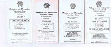
Ephemera - Timetable/s, Melbourne and Metropolitan Tramways Board (MMTB), Set of 14 MMTB Melbourne bus timetables, 1969
Set of 14 MMTB timetables for various bus routes, dated July 1969. Generally includes Sat and Suns, Good Friday and Christmas day as well as weekdays, unless noted otherwise. Also includes a map of the route, detailed time points, sections, connecting services, fares, and organisation address - 616 Little Collins St. Melbourne. Have been folded into eight or ten portions. All on white paper unless noted otherwise. Items shown with an # - have a sticker modifying timetable information details on the front page. Items shown with a % are larger size sheets of paper, folded into 10. 1155.1 - Clifton Hill - Elsternwick # .2 - Garden City - City # .3 - Fishermen's Bend - City .4 - Box Hill - East Doncaster via Blackburn, Mitcham via Donvale PO and Mitcham - Ringwood via Eastland .5 - Warrandyte via Templestowe, via East Doncaster, Donvale PO - City % .6 - Warrandyte, Park Orchards Ringwood .7 - Williamstown Rd., Footscray Railway Station, Ballarat Rd # .8 - Latrobe University, Northland, West Heidelberg - City # % .9 - Deer Park, Sunshine Park, Sunshine, Footscray - City # .10 - as above, but for Saturdays and Sundays on pink paper # .11 - Box Hill, Heidelberg, Templestowe .12 - Box Hill, North Blackburn .13 - East Kew, Box Hill, Doncaster .14 - Bullen, North Kew - City # % Images of a sample of documents added 16-11-2013. mmtb, timetables, melbourne -
 Ballarat Tramway Museum
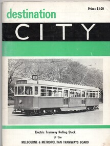
Book, Keith Kings, "Destination City", 1971
"Electric Tramway Rolling Stock of the Melbourne and Metropolitan Tramways Board", priced at $1, published by Traction Publications of P.O. Box 438, Canberra City in 1971, 3rd edition with a small corrigenda sheet. Describes Melbourne s tram car fleet. Includes brief description of each type, photographs and a summary history. Has many photographs of the various tramcars associated with relevant text. On front cover, has W7 1010 with green and black banding and price. On page 1 is a map of Melbourne tramways drawn in 1971, but showing abandoned lines as well. Page ii, inside cover, has a list of Traction Publications. Back cover has a end on photograph of SW6 940. Outside of covers is gloss paper. Corrigenda sheet - 85mm sq has been placed inside its own cover and numbered 1803a. Yields information about Melbourne's tram rolling stock or tramcars.Book - "Destination City" - card covers - 84 pagestrams, tramways, melbourne, tramcars, mmtb -
 Ballarat Tramway Museum
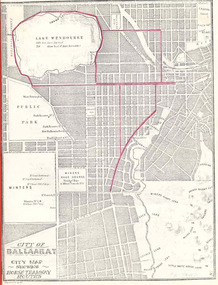
Book, City of Ballaarat, "Mayors Special Report Ballarat Tramways", Sep. 1971
Historically significant for at the time it demonstrated aspects of the evolution of Ballarat Tramways and yields information about the formation of the tramways, the Councils viewpoint and has a strong association with the Mayor of the time.Twenty two page book, produced by photocopying, side stapled and bound with a red plastic binding, titled "Mayor's Special Report Ballarat Tramways", dated 20 September 1971 for presentation to the City of Ballaarat Council Meeting 27 Sept. 1971 and signed by the Mayor, J.A.Chisholm. Note pages 18 and 19 have been reversed. Comprises: Page 1 - map (image 1829i1) - of Ballarat (Ballaarat) showing the horse tram routes in red (appear to have been drawn in with a red pencil). Note the Sebastopol route terminates at Rubicon St. Page 3 - letter to the City Councillors from the Mayor Page 4 - Outline of the "The Ballarat Tramway System" Pages 5 - 7 - Conditions for tendering the horse tram system within the City of Ballarat" Pages 8 - 11 - Specifications and Agreement for the Ballaarat Tramways (horse trams). pages 12 - 19 - Memorandum of Agreement with the British Insulated Wire Company (later ESCo) Page 20 - Copy of letter from the Secretary of the SEC to the Minister of Fuel and Power, dated 10 Sept. 1971 advising of the formal abandonment of the Ballarat and Bendigo tramway systems. Page 21 - five photos (image 1829i3) of trams in Ballarat, including the bogie tram decorated for the Queens visit, courtesy of Mr. L. J. Denmead, Tramways Superintendent. Page 22 - Plan (image 1829i2) of Ballarat Bus Services, showing route numbers, destinations and existing tramway routes. 3rd copy added 16/7/2010trams, tramways, city of ballaarat, mayor's reports, ballaarat tramway company, british insulated wire company, esco, bus services, sec