Showing 924 items matching "land subdivision"
-
 Eltham District Historical Society Inc
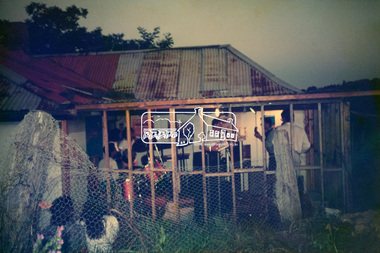
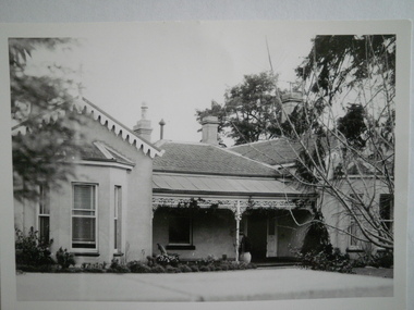
Photograph, Hans Gregory, Original 1860s William West house, Fabbro's Farm, Falkiner Street, Eltham, c.1990
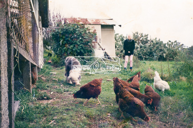
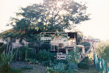
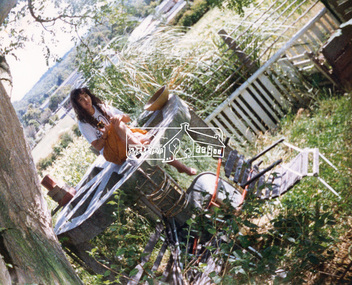
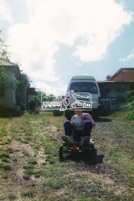
... for residential subdivision. The Bell Street land is now public open space... for residential subdivision. The Bell Street land is now public open space ...Photos taken by Hans Gregory who along with partner Pauline Steele, rented the original old 1860s William West Cottage situated behind the Fabbro family home. Hans was employed as a Youth officer with the Shire of Eltham at the time and was the last tennant on the property. The property was sold and in 1995 was developed for residential housing as the Riverview Park estate. Guido Quarto Fabbro was born 21 August 1891 at Treppo Grande in the far northeast of Italy, the son of Giacomo Fabbro and Anna Geruzzi. Regina Moretti was born 6 March 1893 at Treppo Grande, Italy, the daughter of Giovanni Battista Moretti and Maria Teresa Coletti. Guido and Regina married about 1917 and they had two sons, Giacomo (John c.1918) and Maurie (c.1920). In 1925 Guido Fabbro departed his homeland from Genoa, arriving in Fremantle, Western Australia in June, travelling 3rd class aboard the ship, Caprera. Regina and their two boys followed a year later along with other family members arriving in Fremantle from Genoa 4 July 1926 aboard the Moncalieri. The Fabbros arrived in Eltham in 1933 and purchased a block of land from William West on the western side of Falkiner Street, extending to Ely and Porter Streets which had formerly been part of the West family orchard and dairy farm. As there was no fencing dividing the two properties, West served notice on Guido in December 1934 to bear half of the cost of £6. When payment was not forthcoming, West sued Guido in the Eltham Court in January 1935. Guido failed to appear and was not represented, and costs were ordered in West’s favour. Guido and Regina built a large Italianesque house on their property. The original 1860s cottage was relocated to the back of the block and was rented out (once to Alistair and Margot Knox). Guido also purchased land extending to the Diamond Creek on the eastern side of Falkiner Street and on the eastern side of Bell Street (opposite Eltham High School). The riparian soil was suitable for market gardening: Guido grew mainly tomatoes, but also pumpkins, cauliflowers, cabbages, peas, beans, lettuce, beetroot and zucchinis. Even the land surrounding the house was used. The produce was carted to Melbourne overnight for sale at the market. Guido died in 1970 and is buried in Eltham cemetery. Regina died 1986. She and their son John Patrick (Giacomo) Fabbro who died in 1984 are also buried at Eltham Cemetery. Guido’s son Maurie continued in his father’s footsteps until 2007, principally growing artichokes in later years. He died in 2009. The land on the eastern side of Falkiner Street now forms part of a Council reserve called “Barak Bushland”, the land on the western side having been sold off for residential subdivision. The Bell Street land is now public open space managed by Nillumbik Shire Council and called “Fabbro Fields”. There have been recent proposals to develop the site for sporting purposes or as a dog park or community garden. Provides an insight into early settler's farmhouses and farming property of the Eltham district.guido quarto fabbro, regina fabbro (nee moretti), william west, maurie fabbro, fabbro's farm, hans gregory, west family orchard, west dairy farm -
 Eltham District Historical Society Inc
Photograph, Hans Gregory, Original 1860s William West house, Fabbro's Farm, Falkiner Street, Eltham, c.1990
... for residential subdivision. The Bell Street land is now public open space... for residential subdivision. The Bell Street land is now public open space ...Photos taken by Hans Gregory who along with partner Pauline Steele, rented the original old 1860s William West Cottage situated behind the Fabbro family home. Hans was employed as a Youth officer with the Shire of Eltham at the time and was the last tennant on the property. The property was sold and in 1995 was developed for residential housing as the Riverview Park estate. Guido Quarto Fabbro was born 21 August 1891 at Treppo Grande in the far northeast of Italy, the son of Giacomo Fabbro and Anna Geruzzi. Regina Moretti was born 6 March 1893 at Treppo Grande, Italy, the daughter of Giovanni Battista Moretti and Maria Teresa Coletti. Guido and Regina married about 1917 and they had two sons, Giacomo (John c.1918) and Maurie (c.1920). In 1925 Guido Fabbro departed his homeland from Genoa, arriving in Fremantle, Western Australia in June, travelling 3rd class aboard the ship, Caprera. Regina and their two boys followed a year later along with other family members arriving in Fremantle from Genoa 4 July 1926 aboard the Moncalieri. The Fabbros arrived in Eltham in 1933 and purchased a block of land from William West on the western side of Falkiner Street, extending to Ely and Porter Streets which had formerly been part of the West family orchard and dairy farm. As there was no fencing dividing the two properties, West served notice on Guido in December 1934 to bear half of the cost of £6. When payment was not forthcoming, West sued Guido in the Eltham Court in January 1935. Guido failed to appear and was not represented, and costs were ordered in West’s favour. Guido and Regina built a large Italianesque house on their property. The original 1860s cottage was relocated to the back of the block and was rented out (once to Alistair and Margot Knox). Guido also purchased land extending to the Diamond Creek on the eastern side of Falkiner Street and on the eastern side of Bell Street (opposite Eltham High School). The riparian soil was suitable for market gardening: Guido grew mainly tomatoes, but also pumpkins, cauliflowers, cabbages, peas, beans, lettuce, beetroot and zucchinis. Even the land surrounding the house was used. The produce was carted to Melbourne overnight for sale at the market. Guido died in 1970 and is buried in Eltham cemetery. Regina died 1986. She and their son John Patrick (Giacomo) Fabbro who died in 1984 are also buried at Eltham Cemetery. Guido’s son Maurie continued in his father’s footsteps until 2007, principally growing artichokes in later years. He died in 2009. The land on the eastern side of Falkiner Street now forms part of a Council reserve called “Barak Bushland”, the land on the western side having been sold off for residential subdivision. The Bell Street land is now public open space managed by Nillumbik Shire Council and called “Fabbro Fields”. There have been recent proposals to develop the site for sporting purposes or as a dog park or community garden. Provides an insight into early settler's farmhouses and farming property of the Eltham district.guido quarto fabbro, regina fabbro (nee moretti), william west, maurie fabbro, fabbro's farm, hans gregory, west family orchard, west dairy farm -
 Eltham District Historical Society Inc
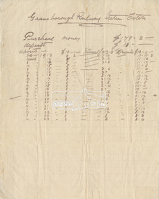
Document - Folder, Greensborough Railway Station Estate, Lots 26, 26A and 26B, Crown Portion 3, Parish of Nillumbik, County of Evelyn (Rattray Road, Montmorency)
Crown Portion 3 of Eltham, Parish of Nillumbik, County of Evelyn, Lots 26, 26A and 26B were part of the Greensborough Railway Station Estate. The land detailed is bounded by present-day Rattray Road, Reichelt Avenue, Wooded Way and Ryrie Court, Montmorency. Originally purchased in September 1913 by George William Miller, signwriter of Greensborough and Harry Frederick Miller, the land was sold to Mrs Margaret Barr Honeyman, 24 June 1918 on mortgage for £400, deposit paid £150. In February 1920, Mr Honeyman called for the title and paid off the loan early, settlement occuring 11 October 1920. Contents: 1. Handwritten payment plan (Sep 1913 to Mar 1923) for Lots 26, 26A and 26B being parts of Crown Portion 3, Parish of Nillumbik, County of Evelyn on the plan of subdivision making up the Greensborough Railway Station Estate situated on Rattray Road; purchased for £179.2.0 with a deposit of £18.0.0. 2. Receipt: From Messrs G.W. and H.F. Miller for £11.15.8 being instalment and interest, 9 Sep 1913 3. Invoice: To Messrs G.W. and H.F. Miller for £11.12.0 being instalment and interest due 15 Sep 1914 4. Contract of Sale: George William Miller and Harry Frederick Miller to Mrs. Margaret Barr Honeyman, in respect of sale of Lots 26, 26A and 26B for £400.0.0, 24 June 1918. Deposit of £150.0.0 balance to be paid half yearly instalments of £15 with interest at 5% per annum added. 5. Letter: Percy J. Russell, Solicitor to G.W. Miller, 5 Feb 1920 advising Mr Honeyman has called for the title and wishes to pay off mortgage. 6. Letter: Percy J. Russell, Solicitor to G.W. Miller, 11 Oct 1920 advising settlement and payment of Miller to Honeyman.contract of sale, george william miller, greensborough railway station estate, harry frederick miller, land sale, margaret barr honeyman, montmorency, rattray road, reichelt avenue, ryrie court, wooded way -
 Eltham District Historical Society Inc
Photograph - Digital Photograph, Jim Connor, Edendale Farm Homestead, 11 December 2014
... Holloway's Little Eltham subdivision. Despite clearing the land... Holloway's Little Eltham subdivision. Despite clearing the land ...Edendale Farm is Nillumbik Shire Council's environment centre situated in Gastons Road, Eltham between the railway and the Diamond Creek. The homestead on the property was built in 1896 and is of historical significance, being the subject of a Heritage Overlay under the Nillumbik Planning Scheme. The Edendale property was originally part of an extensive land purchase in 1852 from the Crown by pioneer Eltham farmer Henry Stooke. He initially purchased 51 acres and later expanded his holdings by purchasing another three adjacent Crown allotments extending northerly from Josiah Holloway's Little Eltham subdivision. Despite clearing the land, Stooke did not build on this property, choosing to live on his property "Rosehill" at Lower Plenty. In 1896 Thomas Cool, Club Manager of the Victoria Coffee Palace in Melbourne purchased 7 acres of the original Stooke land and built the house now known as Edendale. Cool did not farm the land, instead using it as a gentleman’s residence, retiring to Eltham at weekends. In 1918 he purchased an additional 7 acres but in 1919 he sold the property. Later owners included J.W. Cox, the Gaston family and D. Mummery. In the 1980s the Eltham Shire Council purchased the site for use as a Council depot, but this use did not proceed. Subsequently, it was used as the Council pound. The Edendale Farm Pet Education and Retention Centre was established in the summer of 1988/1989 and was set up to replace the existing dog kennels with a high standard pet retention centre. The design style of the building was established to compliment the features of the existing house. It was equipped with 10 retention pens, a veterinary room and a pet education area where school children and other interested parties learnt about pet care procedures. It was later developed into a community farm and was run by an advisory committee and in 2000 it became an Environment Centre. In early 2006 an advisory committee was established for the development of a master plan for future development at Edendale Farm. The committee included Russell Yeoman, a former long-time shire planner and founding member of the Eltham District Historical Society. At the time of filming the Master Plan and future for Edendale was about continuing to develop Edendale as a centre of environment learning and looking at expanding displays and school program, running a lot more of life-long learning and workshops around sustainable living.jim connor collection, edendale community farm, edendale farm, eltham, gastons road -
 Glen Eira Historical Society
Letter - Lirrewa
... . Lirrewa Lirrewa Grove O’Donnell J Fulton Thomas Land subdivisions ...Four articles on Lirrewa’s history, conservation study and notes on architectural features and correspondence from National trust to Mrs W Brooks. Photocopy of an extract from Caulfied Historical Newsletter (No 4 April 1973) containing 2 articles about Lirrewa and Caulfield (one by J O’Donnell, one by Mrs AP Bell) Photocopied extract from the Caulfield Conservation study detailing history and features of Lirrewa written by Andrew Ward (January 1995) Handwritten notes on architectural features of home and hand drawn designs of side and centre windows and design above all main room doors. Includes typed directory listings from 1886 to 1921. Date and author unknown Copy of correspondence to Mrs W Brooks from the Administration National Trust of Australia regarding classification Lirrewa 20/03/1973 and stables.lirrewa, lirrewa grove, o’donnell j, fulton thomas, land subdivisions, glen eira road, glen huntly road, kooyong road, tennant dr, cox james dr, brooks walter richard, baby health care, bryce percy h, sylverly, house names, market gardens, chinese community, langdon montague william, langdon henry joseph, rosecraddock, langdon elizabeth, tarqua, st marys church, caulfield, hawthorn road, lirrewa grove, stables, architectural features, brooks gladys, brooks walter, councillors, scott robert, redcliff mr, architects, mcculloch mr, teachers, office workers, farmer mr, ward andrew, mansions, verandahs, slate tiles, fountains, leadlights, fireplaces, grant rs, black rs, anderson p, russell edwin r, cast ironwork, flats, marble, mantel pieces, gothic revival style, brick, arches -
Glen Eira Historical Society
Drawing - St. Stephen’s Presbyterian Church, Caulfield
... . Watson T.C. Mr. Attwood W.B. Mr. Wells Organisation Land ...Two copies of a sixteen page booklet titled First Fifty Years, detailing a brief history, researched by John Watson, of St. Stephen’s Presbyterian Church, Balaclava Road Caulfield, between 1910-1960. The booklet includes several images, including two photographs, one of the interior of the church, the other of the interior of the main hall. There is also a set of six portrait photographs of the ministers of St. Stephen’s from 1913-1960. There is also a photograph of the front view of the first church and a sketch by Haddon and Henderson architects of the design for the present, 1960, church dated to the early-mid 1920s. There is a list of names of office-bearers for the year 1960. That list has been photocopied and is included in the file. Finally, there are two pages of handwritten notes, undated and unattributed, of information about St. Stephen’s derived from the First Fifty Years booklet.caulfield, st. stephen’s presbyterian church, presbyterian church, balaclava road, caulfield west, oulton street, watson john, kerry gordon f.g. rev., currie george, kinross george, haddon robert, thomson william rev., pollard mr., hunter c. hay m.a. rev., burns hugh m.m.a.b.d. rev., tamagno f. rev., simpson w.l. rev., goddard s.a.m.a.b.d. rev., robinson e.b. rev., adamson j. mr., jamieson r.f. mr., fraser w. mr., tannahill a.s. mr., mcilroy r. mr., smith f.b. mr., josephs a. mr., mac callum d. mr., darby g. mr., watson t.c. mr., attwood w.b. mr., wells organisation, land subdivisions, clergy residences, churches, settlements, community services, sunday schools, religious structures and establishments, architectural features, stained glass, paintings, farms, religious groups, ministers, monuments and memorials, clubs and associations, sporting clubs, p.w.m.u., presbyterian women’s missionary union, p.f.a., p.b.a., p.g.a., men’s brotherhood, soldier’s welfare association, youth executive, women’s league, dramatic club, halls, committees of management, building construction, fundraising events, business and finance, festivals and celebrations, religious ceremonies, architects, choirs, christian religion -
Glen Eira Historical Society
Article - Attwood Family
... Land Subdivisions Air Raid Precautions Bicycles Drawing ...Two items about the Attwood Family: A seventeen page computer typed copy of the memories of John Attwood, compiled by Colin Smith in January 2002. Includes memories of his childhood, contact and impressions of local identities including Merric Boyd and others; the retailers and business owners in the Murrumbeena area, the trains and railway stations, picture theatres and other businesses. A photocopy of an article taken from the Herald Sun newspaper 06/11/2007. Myra Attwood, wife of John, local business person in Murrumbeena Newsagency; includes brief local history of family and Myra’s personal hobbies, till the time of her death. Also a newspaper clipping of her death notice, unknown source and date.emily street, murrumbeena, elsternwick, railway stations, signal boxes, beena avenue, murrumbeena state school, primary schools, attwood john, attwood myra, attwood rhonda, attwood colin, attwood warren, attwood murray, attwood janine, attwood susan, attwood michael, attwood greg, attwood gerard, black bridge, outer circle railway, murrumbeena newsagency, newsagents, murrumbeena railway station, railway stations, book binders, stevens alf, sykes harold, attwood motors, neerim road, boyd merric, boyd mrs., timber houses, outbuildings, artists, trains, car parks, christie’s woodyard, ferguson cam, railway accidents, ardyne street, north road, dalny road, brett street, barnes family, newspapers, roads and streets, soils, flower growing, market gardens, world war 1939-1945, land subdivisions, air raid precautions, bicycles, drawing, springthorpe park, mass media, murrumbeena shopping centre, butcher shops, grocer shops, green grocers, shoe shops, confectionary shops, barber shops, beck george, bowyer ralph, rennie bill, bookmakers, presbyterian church, methodist church, hanna’s milk bar, sunday school, woodland bill, ssw grocery chain, drays, woodland alec, lee ron, jewellers, bakeries, fish shops, dressmakers, delicatessens, east bentleigh, selkrigs family, pottery, heads’ garage, head lindsay, head doug, head clarry, head ron, murrumbeena road, car retailers, petrol pumps, motor vehicle repair shops, billy one motors, bird mr., real estate agents, w.b. tonks and company, sparrow mr., pidgeon mr., hardware stores, florist shops, murrumbeena post office, tile shops, gardens, murrumbeena chamber of commerce, kiosks, gardeners, carnegie citizens band, spurway nursing home, argosy theatre, cinemas, dance halls, the capri, theatre groups, caulfield council, the blowfly train service, billiard rooms, printers, hammond olsen and company, l.j. miles and company, moody’s real estate agency, paddocks, flats, es&a bank murrumbeena, esanda bank murrumbeena, state savings bank murrumbeena, commonwealth bank murrumbeena, fuel merchants, hobart road, golden fleece service station, quince’s buses, bus services, ardyne street, timber yard, gow mr., railway parade, shell service station, pharmecies, house miss, bicycle shops, barnhill les mr., fliner mr., boot makers, widdop peter, moran and cato’s, grocers, pizza shop, car yards, classic caravan, o’brien kevin, wrought iron work, williams mr., candle making factory, lights, power tom, gates, fences, whitelaw monier tiles, whitelaw bill, hanna rex, dandenong road, cumloden grammar school, independent schools, emmaus rest house, oakdene, house names, taranto bob, hanson cab service, billy one motors, grey mr., horse troughs, horse drawn vehicle, taxis, board roy, buick cars, charleston’s bakery, carnegie, rosstown hotel, corum’s dairy, kangaroo road, reids dairy, dalny road, reid shaver, racehorses, cove’s dairy, wilson street, police, murrumbeena police station, dunoon street, murrumbeena park, footballers, gangs, liberal party, labour party, united australian party, uap, woodland alec, liquor shops, johnson suzanne, singers, taylor squizzy, boyd family, artists, criminals, skase christopher, skase charles, sunaria competition, herald and weekly times, ralph j.w., j.h. ralph butchers, butcher shops, pennington gardens, home units, flats, schrape frank, builder, smith colin, mansions, death registers, hockley myra, esperanto, book keepers, accountants, solicitors -
Glen Eira Historical Society
Document - Lempriere Avenue, 10, St. Kilda East
... . Kilda East, built on a subdivision of the land of William George... Lempriere Avenue, St. Kilda East, built on a subdivision of the land ...A brief history of the property at 10 Lempriere Avenue, St. Kilda East, built on a subdivision of the land of William George Lempriere. Includes some information on the Lempriere Family and public park, Greenmeadows Gardens. The document by Rosalind Landells, David Bick and Hilary Bullock of the Brighton Historical Society is dated October 30, 1995. Includes handwritten notes covering mostly same information. Includes bibliography.greenmeadows, lempriere william george, clarke william senior, lempriere john thomson, zimmerman a.k., nelson frank l., greenmeadows gardens, lempriere avenue, nelson m.d., st. kilda east, parks and reserves, zucker a.a., greenmeadows lane, lempriere family, lempriere’s paddock, councillors -
Glen Eira Historical Society
Plan - Pascoe Avenue, 26, Bentleigh
... Ave Land Subdivisions Land Values Bentleigh Pergolas ...Document detailing two valuations by National Trustees Co of the property at 26 Pascoe Ave, Bentleigh, the first valuation is dated 14/07/1954 and the second dated 19/07/1957. Included are handdrawn plans, handwritten notes and typed valuations listing values of architectural features, and correspondence from National Trustees Co. for both 1954 and 1957. The 1954 documents were clearly used in the 1957 valuation.pascoe ave, land subdivisions, land values, bentleigh, pergolas, architectural features, parish of moorabbin, plans, architectural styles, county of bourke, maps, brick houses, national trustees co, illustrations, dendy’s crown special survey -
Glen Eira Historical Society
Document - Seymour Road, 47, Elsternwick
... . Marcola Seymour Road Elsternwick Beemery Park Land subdivisions ...Two documents (with working notes) about the history of this property: 1/Typed document dated 03/06/1989 from Brighton Historical Society covering history of owners/residents from 1891 to 1974 with particular history of the Siddall family. Handwritten undated working notes accompany the document. 2/Typed document dated 22/07/1989 from Brighton Historical Society covering history of owners/residents for a shorter period 1891 to 1957. This one inclueds more detail about the other longterm occupants as well. Handwritten undated working notes accompany the document.marcola, seymour road, elsternwick, beemery park, land subdivisions, bullock hillary, landells rosalind, hubbard edward w, lazarus mark, mccrea d g rev, mackay angas, patterson john r, robertson john r, de hugard alex, siddall jas w, siddall norman, caulfield grammar school, siddall phyllis, brock ella, siddall mrs, whitehead alfred e, brock john, jackson pp, murphy te, house names -
Glen Eira Historical Society
Document - Roseneath, Nepean Highway, 31, Elsternwick
... Brick Houses Verandahs Cast Iron Work Bluestone Bay Windows Land ...A photocopy of a Caulfield Conservation Study conducted in January 1995 by historian Andrew Ward of the house Roseneath named thus by 1904. The document includes a photocopied photograph of the front façade, although the features are unclear. The document, which includes a bibliography, details the history of Roseneath, including owners and occupiers, as well as the architectural features of significance and historical value.ward andrew, millar william, boyle andrew, worthington george, tulloch annie, cross anastasia, meek alex, caulfield, roseneath, elsternwick, nepean highway, mcmillan street, point nepean road, rusden street, cumbernauld, hawthorn road, glenmoore, st. georges road, caulfield south, shire of caulfield, east st. kilda riding, historic buildings register, national trust register, national estate register, italianate style, architectural styles, architectural features, mansions, brick houses, verandahs, cast iron work, bluestone, bay windows, land subdivisions, merchants, judges, leases, councillors -
Glen Eira Historical Society
Document - Tucker Road, 240, McKinnon
... Community Andrews James H. Builders Land Subdivisions Manufacturing ...A photocopy of undated research notes by Hilary Bullock f Brighton Historical Society describing the history of the property at 240 Tucker Road, McKinnon includes a brief history of the area and a list of the tenants from 1880 to 1955.tucker road, mckinnon, masters william h., manchester road, north road, draper thomas t., masters w. h. and co., electrical apparatus, market gardeners, market gardens, mcdonald henry, hewton d.r., church of england centre road, centre road, marquis leslie, monger arthur, devereaux john, priddeth charles, ianson h., chinese community, andrews james h., builders, land subdivisions, manufacturing industry, telegraph, telephones -
Glen Eira Historical Society
Document - Villiers Street, 2, Elsternwick
... of house interior. Villiers Street Elsternwick Land Subdivisions ...Printed and handwritten duplicated copy on the history of Villiers Street by Hilary Bullock. Also gives names of tenants and property owners from 1892 to 1974. Brief description of house interior.villiers street, elsternwick, land subdivisions, hendrick john, robertson george, gillespie j., haines w., johnson charles, reeves christine, quinlan john f., quinlan william, wykes leonard, wykes i.f., tarrant george, laity r.j., thout r. zoe -
 Glen Eira Historical Society
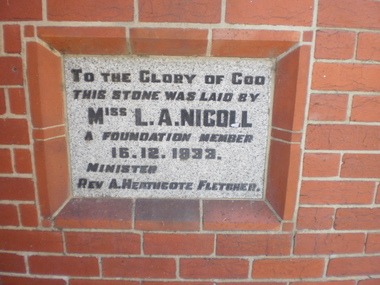
Article - St. Andrew’s Presbyterian Church, North Road, Gardenvale East
... to Glen Eira News and City Council re-proposed subdivision... of letter to Glen Eira News and City Council re-proposed subdivision ...Handwritten document giving brief details on wording on foundation stone of St. Andrew’s church, undated and author unknown. Photocopy of pamphlet produced for the stewardship campaign 1957 for St. Andrew’s Presbyterian Church Gardenvale East, with several photos. It includes history as well as current situation at 1957. Photocopied notes and photo of the Army Hut used by Gardenvale Primary School in 1921 only as donated by church for and year then Reverted back to church use. Photocopy of letter to Glen Eira News and City Council re-proposed subdivision of church land from Robert W. Sinclair.st. andrew’s presbyterian church, foundation stones, nicoll l.a., heathcote-fletcher a. rev., north road, seach street, smith a. f.h. rev., mcneilage alex rev., gardenvale east, caulfield south, younger street, gardenvale east church, nicholls rev., rowlands w. rev., lang walter, sunday schools, yeaman f.e. rev., brown f.e., brick, towers, manse, choirs, groups, smith mrs., curtis e.e., morse roger, marryatt harry, pegler adrian, savill t., south caulfield, gardenvale primary school, sinclair robert w., dakin ms., campbell felicity -
Glen Eira Historical Society
Document - Hartington
... Hartington Street Justices of the Peace Ward Andrew Land subdivisions ...A two page photocopy of a Caulfield Conservation Study by Andrew Ward, dated 10/1994, on the house Hartington at 15 Gladstone Parade. The study gives a description of the architectural features of the house, a brief history of the house and includes a photograph (100mm x 153mm) of the exterior of the house.kooyong park estate, hartington, burnett templeton captain, kirkham charles f, gladstone parade, clarence street, victorian style, hartington street, justices of the peace, ward andrew, land subdivisions, architectural styles, architectural features, windows, elsternwick, caulfield conservation study -
Glen Eira Historical Society
Article - Long Street, 22, Elsternwick
... Road Buxton Advertisements Land Sales Auctions Land ...Two items in the file (1) Typewritten notes, dated 03/02/1988, written by Mrs Rosalind Landells and researched by Miss Hilary Bullock regarding the history of 22 Long Street, Elsternwick and the street in general. Both sides of the page have notes, but are more or less the same in content. (2) The second item is an advertisement, dated 02/03/2005, source unknown, for 22 Long Street, Elsternwick regarding the sale of the house. The architectural and other features are described a copy of a photograph is included.elsternwick, caulfield grammar, rogers mark, long street, ripponlea, landells rosalind, caulfield, sargood, bullock hilary, glenhuntly road, victorian style, architectural features, st george’s road, buxton, advertisements, land sales, auctions, land subdivisions, depression 1890s, property developers, real estate agents, real estate agencies, corner stores, businesspeople -
 Glen Eira Historical Society
Photograph - NETTALIE
... bunya pine trees Trees Orchards Land subdivisions Land sales ...Various documents about and photographs of Nettalie or Netley House or The Nest on Balaclava Road Caulfield now part of Melbourne Grammar School: 1/The first is an article undated and unattributed accessed from Beresford.org on 14/07/2006 detailing with bibliography the history of Netley House including the owners especially the Shaw family. 2/There are several separately colour-printed photographs of the front facade of Nettalie most undated and unattributed, and one family portrait of the Shaw family circa 1863. All were also accessed from Beresford.org on 14/07/2006. 3/One black and white photograph is inscribed '73 Balaclava Rd Caulfield 3/9/72 Neg 16A'. 4/Two copies of a plan of Nettalie next to The Curragh and Harleston, also in the article and likely accessed from same source on same date. 5/A copy of Dr Cameron’s letter to Herbert Shaw dated 24/05/1949. 6/One copy of a letter from Herbert Shaw to Dr William Cameron dated 25/05/1949. 7/A plan of Melbourne Grammar School with each building dated to when it was built including Netley House in 1863.shaw herbert, shaw alfred henry, shaw arthur, shaw amelia, shaw lavinia, forsyth william, blundell mary, fosbery john, bakewell john, hailes george b, blundell miss, stephen george sir, billings richard, ware martha, desailly alfred, cameron william dr, cameron j mrs, nettalie, the nest, netley house, house names, caulfield north, balaclava road, grimwade house, orrong road, harleston, caulfield road district, st kilda east, the curragh, shelford, helenslea, sylliot hall, labassa, o’loughlin street, ormond, hotham street, melbourne grammar school, caulfield conservation study, mansions, teachers, schools, independent schools, hardware stores, business people, lawyers, businesses, brick houses, outbuildings, architectural styles, classrooms, bunya bunya pine trees, trees, orchards, land subdivisions, land sales, doctors -
Glen Eira Historical Society
Plan - Nettalie
... Land subdivisions Land use Settlements Roads and streets Hotels ...An A4 photocopy of the 'Plan of the Caulfield Road District' dated 1867. This plan shows the location of the properties owned by A Shaw and Blundell on Balaclava and Orrong Roads where Nettalie is situated. The plan includes all the landowners listed where their property was, the street names and other landmarks of 1867 including railways, hotels and reserves.caulfield, caulfield north, elsternwick, st kilda east, parish of prahran, parish of moorabbin, caulfield road district, melbourne and brighton railway, rosstown railway, elsternwick railway station, caulfield railway station, rosstown railway station, murrumbeena railway station, baptist church, paddy’s swamp reserve, cemetery reserve, leman swamp reserve, caulfield racecourse reserve, brighton cemetery, the vine caulfield hotel, the tam o’shanter hotel, melbourne hunt hotel, royal hotel, hotham street, horne street, nepean highway, north road, orrong road, dandenong road, princes highway, kooyong road, alma road, inkerman road, balaclava road, glen eira road, glen huntly road, hawthorn road, cemetery road, bambra road, redan road, kambrook road, neerim road, booran road, racecourse road, grange road, koornang road, murrumbeena road, crosbie road, kangaroo road, poath road, ford w, lempriere, cople j, riddell j c, manifold j, testar t, billing r h, semple, blundell, shaw a, butchart g, stephen j w, stephen g sir, hart j, duncan g, blackie r, stephen f, mccombie t, woollaston h, higgins j, lloyd j c, daish j, mcleod j, hughes d, wilson a, jamieson g, webb g h, renwick s, pennington h, dunn j, kirkpatrick w, ricketson w, toad a, sayce j, watts t, widgery, store, guess j, anketell j, clack j, sissen w, clayton g, dickson d, bevan j, hart t, anderson j, hart mrs, webb h, masters s, waghorn j, hemming c, hiam c, farquhar w, newing t, payne t, cooper r, snipe s, chambers j, forster w, summers r, harriman b, warrick, o’connell, long j, peck r, cochrane c, murray ross w, evans c, kennedy j, maclean n, forster, lyall w, dean j, newton h, looker w, baker c, johnston, crosbie j, kerr, jones, parr, nelson c, montgomery l, parsons w, james j c, sibon c, smith sydney w, plans, maps, land subdivisions, land use, settlements, roads and streets, hotels, churches, police stations, post offices, land surveys, railway stations, railways, schoolhouses, commerce, clergy residences, official buildings, local government, road districts -
Glen Eira Historical Society
Plan - Centre Road, 734, Bentleigh East
A one page typed letter, dated 30/09/1970 addressed to S P Simmonds Estate Agency from William Lasica and Co Solicitors requesting a valuation of the property at 734 Centre Road, Bentleigh East. The file also includes four pages of handwritten, undated and unattributed working notes with property description, calculations and a rough plan (96mm x 94mm) of the ground floor of the building for the valuation. Also included in the file is a two page duplicate copy of a typed letter, dated 08/10/1970 from W V Scott to William and Lasica Co Solicitors containing the valuation of the relevant property and rental details. The file also includes a one page photocopy of a handwritten document dated 15/11/1967. It gives details of a previous mortgage. The file also includes a photocopy, dated 26/09/1970, of the Certificate of Title of Lot 6 of Subdivision No 60044 Parish of Moorabbin. It includes a plan of the property (139mm x 123mm).klauss anna sara, klauss edward, green william james, green margaret estelle, green william thomas, myers thomas lee, lombard joseph patrick, graham george kinnell, tobin thomas norman, mcintosh edward joseph, bentleigh east, east bentleigh, centre road, bentleigh station, omeo court, east boundary road, s p l constructions pty ltd, r k c nominees pty ltd, maryland street caulfield investors, flats, land values, land titles, rents, renting, \ -
Glen Eira Historical Society
Document - Riddell Parade, 48, Elsternwick
Two items about this property: 1/A typed Research report on the history of the property at 48 Riddell Parade, Elsternwick, built in 1916/1917 on a subdivision of John Carre Riddell’s land. Prepared by Hilary Bullock and Rosalind Landells of the Brighton Historical Society, dated 14/08/1992. Includes a list of past owners and residents of the property. Their handwritten working notes, undated, are also included. 2/A plan of the subdivision of Riddell Estate from Sand Swamp and Heath (photocopy).cavers carre, riddell john carre, elsternwick, riddell parade, weedon james, walker alice o mrs, foley christina mrs, foley aileen c dr, 'carmel', house names, mcmillan archibald, mcmillan street, 'sand swamp and heath', carre street, gisborne street, landells rosalind, bullock hilary -
Glen Eira Historical Society
Document - Bertram Street, 37, Elsternwick
A one page copy of correspondence dated 22/04/1988 concerning Bertram Street, 37, Elsternwick, the Gardenvale Railway Station and land sales in the area. Researched by the Brighton Historical Society. The file also includes a one page handwritten excerpt from the publication Sand, Swamp and Heath by Murray and Wells, about the subdivision named Gardenvale and the occupiers of Bertram Street, 37, Elsternwick.bertram street, elsternwick, prowse reginald, watson george j, gardenvale, parnell street, muntz street, muntz edwin parnell, muntz thomas b, surveyors, engineers, gardenvale station, market gardens, small and edwards, land developers, gardenvale on the hill, bullock h, landells rosalind -
Glen Eira Historical Society
Document - Cantala
... Mansions Stables Land subdivisions Monuments and Memorials Gothic ...Various documents and correspondence detailing the history of the house and land on the corner of Dandenong and Waiora Roads, Caulfield, known as Cantala before being demolished and the land subdivided. The first document is a typed 3 page history from Caulfield Historical Society dated 02/1974, describing the owner of the property, Septimus Miller, as well as architectural features of the house Cantala. The second document is one page of typed correspondence from T J Hart to the editor of Southern Cross, dated 01/11/1973, describing the architectural features and history of Cantala. The file also includes a copy of a typed letter from Brighton Historical Society concerning research conducted about Cantala and the subdivision and detailing the owners and occupiers of flats erected where Cantala stood. Accompanying this document is a one page handwritten note providing the same details. Finally, the file includes a one page photocopy, undated, of an entry in Who’s Who in the World of Women of Mrs Septimus Miller (Muriel), the second wife and widow of Septimus Miller.miller septimus, miller henry money, mattinson elizabeth, bell clara johnstone, stewart gwendoline, henderson helen muriel, miller ronald nevil damian, salway william, hart t j, miller helen, pirera m t, fetter a, bullock hilary, landells rosalind, redleap, cantala, caulfield, caulfiled north, dandenong road, wiora, waiora road, alma road, brighton cemetery, caulfield racecourse, findon avenue, cantala avenue, olgita, rivoli, caulfield historical society, victoria racing club, horse racing, italianate style, art deco, architectural styles, architectural features, balconies, towers, stairs, bay windows, mansions, stables, land subdivisions, monuments and memorials, gothic (revival) architecture, drawing rooms, walking trails, parks and reserves, gardens, flats -
Glen Eira Historical Society
Document - Cavers Carre
... Railway Cresent Riddell Parade Riddell John Carre Land ...Three articles about Cavers Carre. Handwritten document giving details of the location of the house. Built c.1866 and demolished prior to 1905 when the block was subdivided. No details of the house. Two plans of Gardenvale and Riddell Estate dated 29/11/1884 and unknown from State Library Victoria records.gardenvale estate, glen huntly road, riddell estate, melbourne and brighton railway, mcmillan street, orrong road, archibald street, rowan street, hamilton street, downshire road, shoobra road, madden walter, tuxen august, fraser and co., surveyors, muntz and muntz, cavers carre, elsternwick, stanley street, carre street, railway cresent, riddell parade, riddell john carre, land subdivisions -
 Eltham District Historical Society Inc
Minute Book, Eltham War Memorial Trust Minutes, Book No. 2, 20 March 1951 to 4 June 1957
History of the War Memorial Following the end of the First World War, communities across Victoria and Australia typically erected memorials which were predominantly statues, cenotaphs, avenues of honour and plaques. The Shire of Eltham established the Avenue of Honour at the gateway to the shire as well as an obelisk at the corner of Main Road and Bridge street and the Shire of Eltham War Memorial Tower at Kangaroo Ground. After the Second World War communities once again desired to preserve the memories of those who served and paid the ultimate sacrifice. Resources were scarce so there was a transition away from the traditional style memorials that sprang up post 1918 to one of building facilities that would provide ongoing benefit to the community. Even before the end of the Second World War, the citizens of Eltham began to consider an appropriate form of memorial for those from the area who fought and died in the First and Second World Wars. In 1943 the Eltham Women’s Auxiliary raised funds for the construction of buildings to be established on land to be purchased for the proposed War Memorial. On March 27th, 1945, the Eltham District Progress Association called a meeting of local people who in turn set up and registered the Eltham War Memorial Trust Inc. As a focus for the purpose of the memorial, the newspaper notice read:- ‘Those who have had a member of their family in the fighting services will want to see that the form of a memorial we are concerned with is the one which will be a constant reminder to us of those who fought for us and the little ones for whom they fought and died.’ At that meeting it was decided the Memorial should take the form of a baby health centre along with a creche and children’s library. In late 1945, the newly formed Eltham War Memorial Trust purchased the land at 903-907 Main Road Eltham from Miss Shillinglaw, which once formed part of the Shillinglaw farm on Lot 90 of Holloway’s 1851 “Little Eltham” subdivision. The Governor of Victoria, General Sir Dallas Brooks, laid the foundation stone on November 24th, 1950, in memory of those who fell in the Second World War. The Eltham Infant Welfare Centre was opened November 15th, 1952, the Pre-school on December 1st, 1956, and the Children’s Library in 1961. In late 1966 the children’s library service was integrated into the Heideberg Regional Library Service and the building was officially renamed the Eltham War Memorial Hall. Following the opening of the Eltham Infant Welfare Centre, work began in 1953 planning for the entrance to the grounds, which is signaled by a wrought iron arch entitled “Eltham War Memorial” . In 1954 the Eltham War Memorial Trust decided that a legacy provided by the late Councillor Ernest James Andrew (d. 29 March 1950) in memory of his wife, Mrs. Ellen Andrew (d. 13 July 1946) and who are both buried at Eltham Cemetery, should be used to fund the construction of the entrance. A metal plate inscribed to this effect was attached to the gates. Work on the Memorial Gardens was undertaken throughout the following decade, with a Memorial Forecourt included in the final 1956 plans for the Pre-School Centre. A quote was accepted by the Trust in 1963 for the implementation of a memorial garden, which included grading of a sixty-five foot strip at the rear of the Trust buildings and construction of concrete paths. The stone retaining walls at the front of the site were installed in 1968 when Main Road was widened and it is believed that the Memorial Gates were relocated at that time also. Eltham Senior Citizens Centre In 1964, Eltham Shire Council purchased a section of land from the Trust at the northern end of the site, as a provision for Country Fire Authority buildings. At the same time the Elderly Citizens Club proposed a Senior Citizens Centre on the south western section of the Trust’s property. This was approved by the Trust with the provision that the building was constructed in ‘accord’ with those already existing. In 1965 Council took on board the plans for the Senior Citizens Centre and applied for a government grant. These could only be awarded if Council owned the site. In 1962 the Trust had resolved to hand over the assets to Council once the Memorial Gardens were completed. This was in line with Health Department requirements that grants for the ongoing operation and maintenance of the three facilities would only be made once the the facilities were completed and handed over to Council. In 1965 the Department of Health further demanded substantial alterations to the Pre-School playground as a result of the pending impact of the planned Senior Citizens Centre and Main Road duplication. As a consequence, handover of the Trust’s assets to Council was initiated with a formal ceremony held in the Children’s Library on August 28th, 1965. The Trust continued on as a committee of management for another twelve months. Plans and specifications for the Senior Citizens Centre were prepared by March 1966. Council obtained a grant from the Government which covered one third of the cost and the building was completed by April 1967. Whilst the Senior Citizens Centre is contained within the original Eltham War Memorial building precinct, it was not part of the original Memorial and was not funded by the Eltham War Memorial Trust.A Conquest Account Book manufactured by Norman Bros. (stationers) Pty Ltd, Melbourne. 33 x 20 x 4 cm, green covers; incorrectly noted to March 4th, 1958. Contains various minutes glued, stapled or pinned into minute book and some loose copies of duplicates or missing meeting minutes inserted at appropriate pages. 180 pages, last 26 blankeltham children's library, eltham infant welfare centre, eltham pre-school, eltham war memorial hall, eltham war memorial trust, meeting minutes, minute book, women's auxiliary