Showing 2594 items
matching maps of victoria
-
 Glenelg Shire Council Cultural Collection
Pamphlet - Pamphlets - Portland and surrounds, Victoria, n.d
Collection of pamphlets, information and maps for seven tourist tours of Portland and district. a. green Tour No. 1 Town of Portland b. pale yellow Tour No.2 Portland Harbour c. blue Tour No. 3 Scenic Drive d. gold Tour No. 4 Cobboboonee Forest e. yellow Tour No.5 Nelson, Glenelg River and caves f. pink Tour No. 6 Bridgewater Bay, Lakes, Blowholes g. orange Tour No. 7 Yambuk Lakes, Mt. ClayFront: 'VIVIAN' -handwritten, blue biro, top right -
 City of Moorabbin Historical Society (Operating the Box Cottage Museum)
Document, laminated photocopy of 'Plan of Moorabbin 1850', 1853
Weston Bate, 'A history of Brighton' 1962 informs us that in 1840 Henry Dendy, who was a farmer in Sussex England, paid 5,120 pounds sterling @ 1pound per acre for a 'Special Survey of Land in Port Phillip , Australia. Henry arrived in Australia in 1841 on the frigate 'York' with his wife, son, and three servants. He also took advantage of the Government Assistance of Free Immigrants for Survey Purchasers, to help on his estate and persuaded some Sussex men with their families to follow him. However when Dendy arrived in Port Phillip he found that LaTrobe and Gipps were trying to raise the price of land close to Town to 15pounds per acre. Dendy asked merchant J.B.Were to manage his affairs and they went ahead with plans to subdivide the surveyed land called 'The Brighton Estate' This area of land extended easterly from the Port Phillip Bay to East Boundary Road and from North Road to South Road in the Parish of Bourke Victoria. The Privy Council, England , decide that Henry Dendy could purchase the land at 1pound per acre. Land Sales proceeded from 1844 as more immigrants established market gardens, farms and varied businesses in 'Moorabbin'This is a photocopy of a Map of the Moorabbin , County of Bourke c1850 showing the 'Henry Dendy Special Survey 1841'A photocopy of a Map of the Moorabbin , County of Bourke c1850. A3 size laminatedLeft corner : MOORABBIN / COUNTY OF / BOURKEdendy henry, dendy special survey 1841, brighton, moorabbin, ormond, bentleigh, market gardeners, pioneers early settlers, box william, box elizabeth -
 Geelong RSL Sub Branch
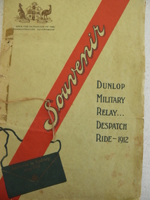
Souviner Program, No makers listed, Dunlop Military Relay ... Despatch Ride 1912, 1912
In 1912 there was a Military Relay Despatch Ride through South Australia, Victoria and New South Wales. The purpose of the ride was to deliver a despatch in the quickest possible time by road through the three states mentioned. The ride was carried out under the auspices of the Dunlop Rubber Company and involved cyclists, motor cyclists and motorists.This is an original program of the event that was carried out in 1912. The program details the list of participants, a map of the route taken and statements of appreciation from the Military and the Promoters', there is also a message of greeting from the Military Commandant, South Australia to the Military Commandant, New South Wales.A cardboard cover program with white thick pages inside.On the front cover a Coat of Arms, a red stripe with souviner written in the stripe and Dunlop Military Relay ... Despatch Ride - 1912.military relay, 1912, despatch ride, dunlop rubber company -
Glenelg Shire Council Cultural Collection
Booklet - Booklet - Port of Portland Victoria 1950 - 1975, c. 1970
4 page booklet with 3 unattached leaflets inside. White textured light card. Black and white photo of Port and seal of pht commissinoners, on front cover. Back cover has Port of Portland Industril and commercial locality map.Front: 'Port of Portland Victoria 1950 - 1975' - Printed in black -
Glenelg Shire Council Cultural Collection
Document - Flyer - Accommodation guide, Portland Victoria, C.H RIXON, Government Printer, Melbourne, n.d
DL size flyer, glossy paper, front green with a white outline map, black print and illustration of Mac's Hotel, Portland. South West regional accommodation guide. -
Glenelg Shire Council Cultural Collection
Document - Flyer - Promotional material for Portland Victoria, n.d
DL flyer, bi-fold, advertising Portland as a place for industrialists to invest in. Textured paper, full colour photographs of Portland and location map.portland industry -
Glenelg Shire Council Cultural Collection
Souvenir - Souvenir - Map and Sticker, South West Victoria, n.d
... Souvenir - Map and Sticker, South West Victoria... to the S.W. region - fold out map, with tourist destinations marked ...a. Tourist Guide to the S.W. region - fold out map, with tourist destinations marked; description on reverse. b. Bumper sticker, round, red, with white print ' 'Victoria, all it needs is you' - Victorian Ministry of Tourism logo. -
Glenelg Shire Council Cultural Collection
Postcard - Postcard - Australia Map and Portland, Victoria, n.d
... Postcard - Australia Map and Portland, Victoria... Postcard - Australia Map and Portland, Victoria Valentine's Series ...Coloured postcard. Map of Australia, which lifts up to reveal a strip of black and white views of Portland. Each view 4.9 x 3 cm. Representation of two 'cowboys' on horseback, with whips, to the left of map of Australia.Front: 'MAP OF AUSTRALIA FROM PORTLAND' -printed in redportland -
Glenelg Shire Council Cultural Collection
Postcard - Postcard - Mac's Hotel Portland, Victoria, n.d
Coloured postcard. Depiction of Mac's Hotel Portland, advertisement, map of location on reverse of postcard.Front: 'MAC'S MOTEL-HOTEL' - black print in white border, bottom edge of postcard -
Glenelg Shire Council Cultural Collection
Booklet, Commissioned by Portland Tourist Association Inc, 'Portland Victoria's Birth Place Welcome to Living History', n.d
Bowerbird MuseumPromotional booklet for Portland and District. Heavy paper covers, green with coloured photos of Portland and district. 44 page booklet, white with black print. Map of Portland and District in centre. Book contains information on Portland, plus National Parks, reacreation, business advertisments. -
Glenelg Shire Council Cultural Collection
Souvenir - Postcard, c. 2000
Contemporary postcard of Portland. 4 full colour views of Portland. 'Portland Victoria, Australia' in white on blue bottle margin, left. Traveller's Notes logo on right. Reverse has line map of Australia. Melbourne indicated, plus rectangular area Portland district. Valued $ 30.15 for 9 items -
Glenelg Shire Council Cultural Collection
Souvenir - Tea Towel - Maretimo, Portland, n.d
From the National Trust register: Statement of Significance Maretimo, a 22 room single storey Australian Colonial Georgian style mansion set on a prominent bluff overlooking Portland harbour, was erected c. 1854 for John Norman McLeod. The design of Maretimo, which is constructed of basalt ashlar with fine-axed parapet entablature, delicate open timber work verandah and Regency interior, has been tenuously attributed to Adelaide architect James Barrow. Maretimo is rivalled only by the stylistically similar Henty residence, Burwsood of 1853 by James Barrow, as perhaps the finest Australian Colonial Georgian style residence erected within the first twenty years of settlement in Victoria. The residence, which was occupied for twenty years by distinguished English-born gentleman parliamentarian, pastoralist and former Van Deimen's Land settler, J H McLeod, is now notable for the disciplined facade and elegantly crafted interiors. Maretimo has been meticulously maintained and is presented in near perfect original condition. The interiors have been sensitively enhanced and redecorated.Linen souvenir tea towel 'Maretimo'. Green and black on cream. 'MARETIMO' at top, front view of Maretimo beneath, then map of locaion, then view from air. 'HISTORIC HOME PORTLAND, VICTORIA' beneath 'Pure Linen', bottom right.historic building, historic homestead, maretimo, henty, souvenir -
Glenelg Shire Council Cultural Collection
Pamphlet, The Holiday Spectacular, c. 1970
Pamphlet. South west Victoria Australia. The Holiday Spectacular produced by Victorian Government to promote tourist attractions. Multi-fold pamphlet, coloured photos, maps, tourist information. -
Glenelg Shire Council Cultural Collection
Booklet - Brochure, The Port of Portland, 1950s
From the collection of the Bower Bird Museum. Heywood.16 page Brochure 'The Port of Portland'. Cover pale blue cardboard with black print. An 8 cm diameter window in front cover showing the Port of Portland stage 1 development, which is part of map on page 1. - this is in colour. The remainder of pages in brochure are in black and white.portland, tourism, travel, economy -
Glenelg Shire Council Cultural Collection
Souvenir - Portland Tourist Information Kit, c. 1988
Identification numbers 7974 a - l Cream cardboard folder. Information kit: brochures / pamphlets/magazines about Portland and surrounds, compliments of Portland Tourist Assoc. Inc. Cover: red outline map of Australia with capital cities in red, and Portland by a blue dot, and 'Portland Victoria's Birthplace' and logo. Red print Portland Victoria's Birthplace above and below blue logo. 'Information kit with the compliments of ' in red print. (See other information)Front: White Portland Tourist Information Centre card stapled to inside of folderportland and surrounds -
Glenelg Shire Council Cultural Collection
Souvenir - Plate - State of Victoria, c. 1984
... beneath map. Back: Time line of Victoria's first 150 years... Cliff Street Portland great-ocean-road Front: 'State of VICTORIA ...White, boxed, fine china Westminster plate, State of Victoria, in green with black place names, floral emblem (pink heath) above state. Gold rim. Plate size is 19cm diameterFront: 'State of VICTORIA 150TH ANNIVERSARY' - blue lettering, above map 1984-5 GROWING TOGEHTER' - blue lettering beneath map. Back: Time line of Victoria's first 150 years - in black print. 150th logo Westminster Australia. Makers mark -
 Greensborough Historical Society
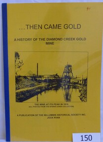
Book, Then came gold: a history of the Diamond Creek Gold Mine: by Jock Ryan, 2001_
The Diamond Creek Gold Mine was active from the 1860s and by 1912 had 12 known shafts. This book outlines ownership and contains anecdotes about the mine.A short history of the Diamond Creek Gold MineBook, 9 pages. Black and white illustrations and maps. Yellow front page with clear plastic cover.John Mackey in pencil inside front cover.diamond creek, john l ryan, jock ryan, diamond creek gold mine, gold discoveries victoria -
 Greensborough Historical Society
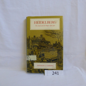
Book, Melbourne University Press, Heidelberg: the land and its people 1838-1900; by Donald P. Garden, 1838-1900
This book covers the early history of Heidelberg, Victoria from its beginnings in 1838 to 1900.There is some reference to the 'annexation' of Greensborough in 1875 and the route of the Heidelberg-Eltham railway line, 1893.Hard cover book. 218 p., ill., maps. Slip cover has a drawing based on an early photograph of the Old England Hotel.Property stamps from Nunawading Public Library (cancelled from their collection)heidelberg, greensborough, donald garden -
 Halls Gap & Grampians Historical Society
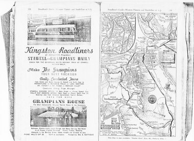
Magazine - Photocopy
Kingston Roadliners (F. Kingston, Proprietor) STAWELL - GRAMPIANS DAILY Coach for the Grampians meets mid day train at Stawell Return Daily Make the Grampians your next vacation Daily Conducted Tours, from Hotels and Guesthouses in Stawell and Hall's Gap to WONDERLAND - MCKENZIE FALLS - LAKE WARTOOK - MT. VICTORY - MT ROSEA - WANNON VALLEY conducted Hiking Trips Arranged Stawell booking office: 75 Main Street - Phone: Stawell 214, Hall's Gap booking office: Main Road - Phone: Hall's Gap 35, Bookings also from Vitorian Government Tourist Bureau, Cars for hire GRAMPIANS HOUSE The Most Conveniently Situated Tourist House in the Grampians. Ballroom, electric light, large garage, hot water service, hot water in all rooms, internal sewerage. Tennis, fishing, shooting, Alongside is the Bowling Green, where visitors are welcome to play. Phone: Hall's Gap 28. Tariff on application. Manageress: Mrs, E. MatthewsAdvertisement for Kingston Roadliners, Grampians House and Map of the GrampiansAdvertisement in Broadbents, Guide of western Victoria, and South-East of S.A.media, advertisements, grampian house -
 Kiewa Valley Historical Society
Photograph Farm Land, Mount Beauty Acreage before Golf Course, Circa 1950
This photograph is a "snap shot" in time circa 1950s detailing the rural environment before the effects of the Kiewa Valley Hydro Scheme altered the basic rural setting of the valley. The golfing fairway was being mapped out on previous grazing land, before the laying of a golf course, for use by the construction workers and auxiliary administration employees of the Victorian State Electricity Commission. This photograph details a dramatic period in time which saw an enormous change to the exclusively rural area of the Kiewa Valley region in the mid 1900s. This change presented both physical and mental challenges to the existing quiet rural inhabitants of the valley. The State of Victoria had to make adjustments to the changing demands imposed by population and industrial expansions. The development of cleaner energy supplies to a growing population has its downside ,which ever way the intrusion into the "natural" landscape is made.Black and white photograph detailing surveyor posts for construction of golf course. Land used, before establishment of the Mount Beauty Village, as farming/grazing cattle and viewed towards Mount Bogong and its Alpine ranges. The photo is on 200gms paper and not on photographic paper.nilmount beauty in the 1940s - 1950s, grazing in the kiewa valley, sec victoria -
4th/19th Prince of Wales's Light Horse Regiment Unit History Room
Card - Christmas Card, 1915 (exact)
Service of Frank Phillips Prior to the commencement of World War I, Frank Phillips served in the Minyip Troop of the Light Horse militia. His civilian occupation was that of clerk. On 22 August 1914 he enlisted in C Squadron 4th Light Horse Regiment. The 4th Light Horse Regiment embarked on the troop ship “Wiltshire “ for training at Mena Camp, in Egypt. During May 1915 the Regiment was deployed to the Gallipoli campaign in a dismounted role. After seven months, the Gallipoli campaigned was abandoned and the troops withdrawn. On return to Egypt the 4th Light Horse Regiment divided with one component deployed to Palestine and the other to the Western Front. Frank went on to serve in Palestine. He was promoted to Sergeant while at Gallipoli and, in Palestine, was promoted to Captain, serving as Adjutant of the Regiment. He was granted furlough to return to Australia from 14 October 1916 to 12 March 1917. On 16 January 1918 he was Mentioned in Despatches Citation: At Hill 750 near Bir El Esani on 30-4-17 he led an attack on Hill 750 under heavy rifle fire capturing the position and 7 armed Bedouins. On 23-5-17 during reconnaissance, he led and attack on 790 under very heavy rifle and machine gun fire and captured the position, inflicting losses on the Turks. He has, at all times, set a fine example of courage to his men. 22 October: 1918 he was awarded the Military Cross Recommendation of Commanding Officer – For exceptional gallantry and devotion to duty on the 28th September 1918, during the crossing of the JORDAN near EL MIN, this officer (adjutant of the Regiment) personally reconnoitred for crossings under heavy M.G. fire and led the Regiment to the only available crossing, rendering invaluable assistance during the crossing. On 3oth September when the Regiment was advanced guard on to KAUKAB, this officer’s personal reconnaissance to confirm patrol reports was of the highest order and utmost value to his C.O. culminating in the capture of KAUKAB with a mounted attack and the The 4th/19th Prince of Wales’s Light Horse Regiment has a long and distinguished history that pre-dates Federation to colonial Victoria’s mounted troops. Our history parallels that of the nation, including its active participation in some of the most inspiring events in Australian Military History including the Defence of ANZAC and the charge at Beersheba. The Regiment is based on a linkage of the two post-World War II Victorian Army Reserve RAAC units - 4th/19th Prince of Wales’ Light Horse and 8th/13th Victorian Mounted Rifles. From these units we derive our links with the six Light Horse Regiments of Victoria and Southern New South Wales (4th, 8th, 13th, 17th, 19th and 20th Light Horse Regiments.) The Regiment proudly bears the guidon of the 4th Light Horse, with the guidons of the remaining regiments being laid up in the crypt of the Melbourne Shrine of Remembrance. During World War I, the 4th Light Horse Regiment served with distinction on three fronts – Gallipoli, Palestine and the Western Front. Corporal, later Captain, Phillips was a member of the 4th Australian Light Horse Regiment. He created the post card while serving with the Regiment as a Corporal at Gallipoli. Post Card hand made and sent to familyFrom Cpl Frank Phillips, 4th Australian Light Horse Regiment. Entries in pencil Front: Addressed to Andrew Phillips (father) at Minyip, Victoria, Message: “A Merry Christmas and Happy New Year to all, Made while on my day out. Love Frank” Reverse Top Centre – 4 LH Badge Centre – cloth map of Australia stapled to card Bottom – Print of flag stapled to card, Irish green ensign, Union flag in canton, gold coloured Irish harp on fly. Notations: Broadmeadows, Wiltshire (Troop Ship), Shrapnel Gully, Suicide Gully, Courtney’s Post Mena, Mex, Heliopolis, Imbros, Gallipoli, Turkish soil underneath (flag), Australia on Turkey, Lone Pine, Leans Trench, Constantinople, All honour to our Irish comrades, To greet you 1915-16. From the shells, yells, and little Hells, of the Darda Dardenelles 0 – 0 May you enjoy your Xmas dinner as I hope to enjoy my Xmas billy in the trenches.ww1, gallipoli, 4th light horse, post card, frank phillips -
 Kiewa Valley Historical Society
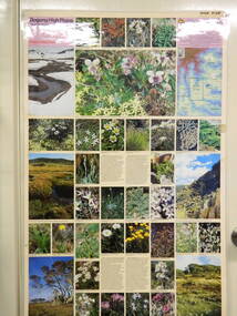
Map / Chart, Vegetation Map & Guide to Alpine Flora: Pretty Valley, 1982
This poster shows Pretty Valley is on the Victorian High Plains where the State Electricity Commission of Victoria worked on the Kiewa Hydro Scheme. Also cattle have grazed in the area over the years. This map is of interest to compare the flora in the area with times prior to 1982 and after 1982.This poster has historical and research value as it shows the flora in the pretty valley area therefore making it significant for people interested in plants. Also for those who would like to compare what plants are still in this area after 1982 and if the cattle grazing, climate change, of bush fires have had on the environment. Thus this poster also has good interpretive capacity of these reasons. Laminated double sided vegetation map and photographic guide to Alpine flora of the Pretty Valley areapretty valley. bogong. vegetation. plants. flowers. alpine. victorian high plains. cattle grazing. s.e.c.v. -
 Kiewa Valley Historical Society
Map / Chart, Vegetation Map & Guide to Alpine Flora: Hotham, 1982
... . vegetation. plants. flowers. alpine. high plains of victoria ...This poster shows Mt Hotham is on the Victorian High Plains. This poster and map enables the comparison to be made of flora in other areas of the Victorian High Plains e.g.. which was previously known as the Bogong High Plains. This poster has historical and research value as it shows the flora in Mt Hotham area therefore making it significant for people interested in plants. Also for those who would like to compare what plants are still in this area after 1982 and if the cattle grazing, climate change, of bush fires have had on the environment. Thus this poster also has good interpretive capacity of these reasons.Laminated double sided vegetation map and photographic guide to Alpine flora of the Hotham area.hotham. vegetation. plants. flowers. alpine. high plains of victoria. -
 Kiewa Valley Historical Society
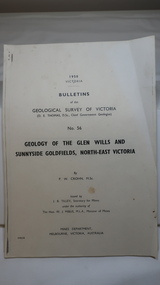
Document - Four Geological reports on the North-east Goldfields, Geological Survey of Victoria 1958 Bulletin
Geological Surveys of N.E. Goldfields Victoria included mines and tunnels. A resurvey of goldfields was necessary to re-assess economic possibilities using modern techniques and structural interpretation. It included an examination of a considerable surface area with maps and underground workings. Results were correlated and integrated and published by the Mines Department.The mines are in the Bogong Alpine Area.Foolscap printed Victorian Bulletins. Each stapled in the top left corner and each with varying number of pages. Covering 1941-1958 a) Glen Wills and Sunnyside b) Sunnyside Tunnel c) Red Robin d) Maud and Yellow Girl Government Printer, Mines Department, Melbourne, Victoriageology in the north-east, gold fields, goldmines, glen wills -
 Kiewa Valley Historical Society
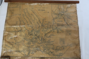
Map - Railway Map of Victoria, Amended to 1/11/1945
... Map - Railway Map of Victoria... of the map Amended to 1/11/1945 Map - Railway Map of Victoria ...Railways began in the 1850s and were privately owned and operated. Later they were taken over by the Victorian Government reaching a peak in the early 1940s.Steam trains were followed by electric trains with both running after the war in 1945.Bright was the closest station to the Kiewa Valley but road transport was used more often as the Kiewa Valley Highway was improved with the construction of the Kiewa Hydro Electric Scheme. To travel to Melbourne or Sydney by train residents went via Wodonga/Albury where they also did their shopping.Plastic on parchment with detailed railway routes (in green) across Victoria including each district's 'Road Foremen' and 'Depots'. There is a length of flat wood attached by 10 tacks across the top of the mapvictorian railways 1945, trains, transport -
 Kiewa Valley Historical Society
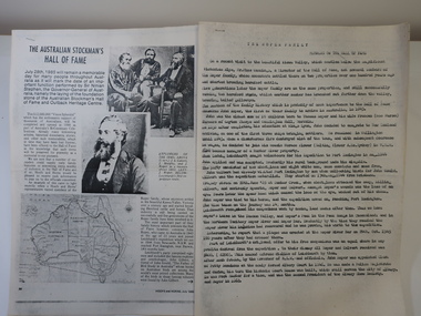
Papers - Roper Family, The Australian Stockman's Hall of Fame
The Australian Stockman's Hall of Fame is a museum located in Longreach, Queensland, Australia, which pays tribute to pioneers of the Australian outback. The centre is also dedicated to Australian stockmen who have shown bravery and courage. Registered in 1974. On July 28th 1985 the foundation stone of the Australian Stockman's Hall of Fame and Outback Heritage Centre was laid. Hoofs and Horns magazine was established by R.M.Williams in 1944 and ceased in 2005. It was aimed at cattlemen and horsemen.'The Roper family's ancestors settled in the beautiful Kiewa Valley, Victoria over a century ago and started breeding Hereford cattle and horses.' This is their interest in Hoofs and Horns but the Hall of Fame is interested in 'John Roper, who came to Australia in 1843 at the age of 23 years and joined Leichhardt's expedition ...'2 papers - Hoofs and Horns, July 1985, Page 88 and page 90 printed with photos and map. The article has the title: 'The Australian Stockman's Hall of Fame' 2 papers - Title The Roper Family compiled by Wilma Davies (nee Roper) and Mr Mike Cummings. Members of the Hall of Fame.. australian stockman's hall of flame, hoofs and horns magazine, cattlemen and horsemen, the roper family -
Kiewa Valley Historical Society
Ron White's Collection - 1920 - 2019
The State Electricity Commission of Victoria constructed the Kiewa Hydro Electric Scheme.See KVHS 1282Ron White was the Principal Hydro Engineer 1966 - 1985 on the Kiewa Hydro Electric Scheme. See KVHS 12821. Booklet "Rules of the Kiewa Hydro Co-operative Distribution Society Limited" and Ron's 'Share Certificate' dated 12th /4/1957 2. Book "Inside Information" explaining the ins and outs of a car for the motorist. 3. Black and White negatives 4. Ron's La Trobe Valley Health Services Membership card x2 5. State Savings Bank of Victoria Kiewa Operations social club 1962 x2 6. The Association of Professional Engineers, Victorian Branch receipts 1956 7. Upper Kiewa Valley Uniting Church list of members 1969-1970 & Financial Statement for 1970 8. 4 Bogong Village coloured postcards 9. Folded Plan of 'Kiewa Area Planimetric Map' 10. Large Photos sent to Ron by "Bill Greenaway / Y.T.S. Lab./ 11-5-66" 1) Football Team x2, 2) Mt Beauty Switchyard, 3) McKay Power Station, 4) Clover Power Stationron white -
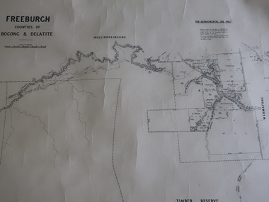 Kiewa Valley Historical Society
Map - Freeburgh - Counties of Bogong and Delatite
... and reproduced at the Dept. of Lands and Survey, Melbourne, Victoria ...Drawn and reproduced at the Dept. of Lands and Survey, Melbourne, Victoria November 1948Black and white map of Freeburgh, County of Bogong and Delatitefreeburgh, map county of bogong and delatite -
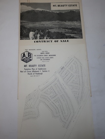 Kiewa Valley Historical Society
Folder - Mt Beauty Estate
After the State Electricity of Victoria completed the construction of the Kiewa Hydro Electric Scheme in 1961 the township of Mt Beauty was sold. The Shire of Bright (currently Alpine Shire) purchased the town and individual houses were put up for sale to the public.The sale of Mt Beauty changed the town - its occupants, its industry, its governance etc. Papers held in a manila folder. They include the Contract of Sale and Maps of Mt Beauty 1961mt beauty township, shire of bright -
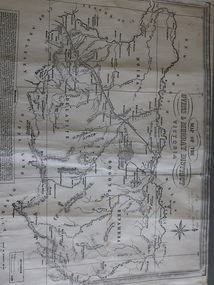 Kiewa Valley Historical Society
Map of the Ovens and Murray District of Victoria
The map features Beechworth and its history.This map features the north-east and in particular, Beechworth where residents of the Kiewa Valley may have shopped or visited for appointments.Black and white map with references to roads and gold. The centre of the map is Beechworth and in the bottom left side of the map is the heading Beechworth with 12 lines of print of information regarding Beechworth. The Kiewa Valley is not identified.beechworth