Showing 1015 items matching "paddock"
-
 Southern Sherbrooke Historical Society Inc.
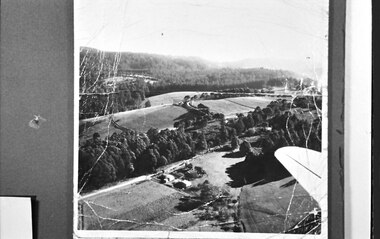
Photograph, Aerial view of Cotswold Valley
Aerial view of Cotswold Valley, Menzies Creek. B&W photos taken from light plane. Paddocks and treed areas are visible. Two houses are in the centre of the photo, presumably the Breen farmhouse on Jacksons Hill Road. The tip of the plane's left wing is also visible. -
 Orbost & District Historical Society
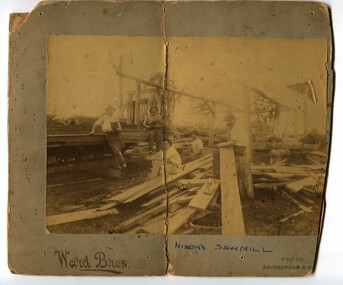
black and white photograph, Ward Bros, late 19th / early 20th century
Around 1885 Mr James Nixon started a sawmill in the paddock below Mr Harry Cameron's dairy. It was in Snaggers Lane on the east side of the present highway. The photo is of James Nixon's sawmill with Percy Nixon in the centre foreground. Orbost has historically been based on the timber industry, but that industry has declined considerably over the last 20 years. The number of locals involved in the timber industry has declined and many of the mills have closed. This item reflects a time when that industry was a significant contributor to the economy of the district.A very yellowed photograph of five men, probably workers, at a mill site. The photograph is on a grey buff card.on front - "Nixon's Sawmill" on back - "Toby Nixon's Sawmill"timber-industry-orbost sawmill-nixon -
 Ringwood and District Historical Society
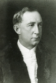
Memorabilia, Brief community and sporting history of Augustus Temple Miles, former orchardist, Mayor of Ringwood, Victoria, and Ringwood District Cricket Association founder life member
Images and information later included in production of "From Paddocks to Parks", a history of the development of cricket in the Lilydale, Croydon, Ringwood and Ferntree Gully districts and of the Ringwood and District Cricket Association, by P.J. McCallum, OAM, Melbourne, April, 2001.2-page handwritten letter from A.T. Miles' son, Edward Temple Miles, accompanied by Ringwood Cricket Club photographs and memorabilia outlining his father's achievements. -
 City of Kingston
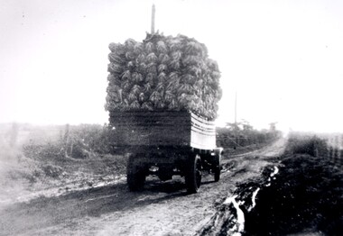
Photograph - Black and white
A truck, fully loaded with cauliflower travelling along McKinnon Road towards Tucker Road. The road is unsealed and recent rains have left large puddles along the sides. Open paddocks appear on either side of the road.Black and white image of a truck fully loaded with cauliflowers travelling along an unsealed boggy road, to market.Black ink printed on a white circular sticker: 32 Handwritten in red ink: 70%vegetables, cauliflower, market, truck, transport -
 Bacchus Marsh & District Historical Society
Map, Bacchus Marsh Suburban Allotments Parwan Road Lodge & Dunn's Paddocks 1888
This map was created as a plan for an auction of land close to the Bacchus Marsh Railway Station. The auction took place on 23 October 1888. 102 allotments of land from an area known as Lodge and Dunn's paddocks was offered for sale. A single page paper map showing allotments of land for sale along the Parwan Road in Maddingley. The map is pasted into a bound volume containing 76 maps or plans in total. High resolution digital image stored on BMDHS computer network. land sales bacchus marsh, land sales maddingley, bacchus marsh victoria maps, maddingley victoria maps -
 Kiewa Valley Historical Society
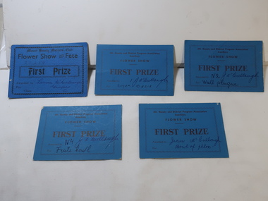
Cards - Gardening First Prize
Mt Beauty township was created in the late 1940s when the SECV built houses, roads, amenities etc. for their workers working on the Kiewa Hydro Electric Scheme. The town was built on a paddock so gardening was popular amongst the population.The residents of Mt Beauty created gardens for their new homes and were encouraged to enter competitions for the best flowers etc.. This was an enjoyable social occasion for them. 5 blue cardboard cards won for First Prize in 'Flower Show and Fete' presented by the Mt Beauty and District Progress Association Auxilary and the Mt Beauty Mothers Club.Name of winner written on each - won by members of the McCullough familygardening, flower show, mccullough family, mt beauty progress association -
 Sunbury Family History and Heritage Society Inc.
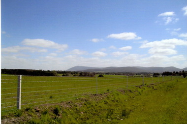
Photograph, Rosa McCall, September 2014
The countryside in this photograph was completely burnt out in February when a severe grassfire raged across the land in February 2024. This is a photograph of the same area taken in the following September 2024 after welcome rain brought growth back on the paddocks.A coloured digital photograph of a green landscape with hills in the background.springtime, grassfires, riddell road, riddells creek -
 Bendigo Historical Society Inc.
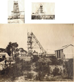
Photograph - NAPOLEON MINE, c1920
3 Black and white photographs of the Napoleon Mine. Image Description: 2 small photos, different views of poppet head and buildings. Larger photo, paddock foreground, poppet head and buildings - fuller view, mounted on masonite. 2 loose photos formaly mounted on black cardboardtopic, mining, napoleon -
 Lakes Entrance Historical Society
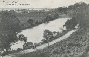
Postcard - Eagle Point bluff, silt Jetties and Jones' Bay, Eagle Point Victoria, A W Burman Bairnsdale, 1912 c
Letter on back dated Dec 30 1912 to Mrs Brewer Signed FloraBlack and white postcard showing view of Mitchell River looking east towards Eagle Point bluff and the silt Jetties and Jones' Bay small farm and buildings, hop kiln on bank opposite bluff and hop paddock. Horse and jinker on gravel road Eagle Point VictoriaMitchell River Eagle Point Bairnsdale waterways, rivers, jetties, roads and streets, transport -
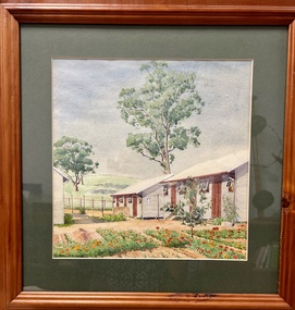
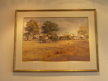 Friends of Westgarthtown
Painting, John Borrack, Last Days Ziebells "The Pines" Thomastown
Painted from the home (or front) paddock which ran south to the creek. The paddock was used for the cultivation of lucerne and maize crops in the lower regions while closer to the house where Ainwick Crescent is now situated, it was a burgeoning market garden for the cultivation of all varieties of vegetables. The large pines beyond, sheltered the farmyard on the west of Gardenia Road. That complex can be partly glimpsed on the left of the painting. This is a directly painted watercolour relying on the use of white paper and transparencies to impart a feeling of morning light. The figure is the artist's mother for whom the picture was painted. Provenance: Augusta Borrack (nee Ziebell) Collection, John Borrack CollectionWatercolour painting, depicting Ziebell's Farmhouse from the south (Thomastown and Mernda). Painting is mounted in a gold frame with cream board.Artist signature: John Borrack; Last Days at Ziebells "The Pines" Thomastown, 'Pro mea matre hanc picturan feci (In Memoria)'illustrations, watercolours, john borrack, ziebell, watercolour, painting -
 City of Kingston
Photograph - Black and white, 5 January 1984
Cheltenham and Heatherton are suburbs in the City of Kingston that were originally established as a rural market gardening community. The market gardens, farms and paddocks have gradually been sub-divided into housing and industrial estates and associated infrastructure such as schools and shopping facilities. This aerial image covers a diverse section of the City of Kingston, taking in the suburbs of Cheltenham, Heatherton, Mentone and Parkdale. By 1984, the market gardens of the district have been replaced by housing and factories. The Nylex factory is visible and now closed. Mentone Bowl on the corner of Warrigal Road and Nepean Highway has now been replaced by high rise apartments, another feature of the changing landscape in the City of Kingston. The vacant land now occupied by the Moorabbin Airport Direct factory Outlet (DFO) is also depicted.Aerial photograph of Cheltenham, Heatherton, Mentone and Parkdale within the City of Kingston. The area depicted in the 1984 aerial view includes Centre Dandenong Road and Cheltenham East Primary School (top left), Kingston Heath Reserve (top right), intersection of Lower Dandenong Road, Warrigal Road, Balcombe Road and Nepean Highway (bottom left), Balmoral Drive/McSwain Street Parkdale (bottom right).White text: 3831-179 Lens information [indecipherable] RINGWOOD M/S 7922-3 RUN 16 [Clockface image] 5,300' ASL VIC DLS© 5-1-84cheltenham, heatherton, mentone, parkdale, market gardens, urbanisation -
 Wycheproof & District Historical Society Inc.
Wool Picture, Wycheproof Craft Group Emblem, 1984 (exact)
The Wycheproof Craft Group emblem made by Mrs Elaine Storey depicts a large ram and showcases beautifully, wool colours and versatility of creator and medium used. The wool industry, since Wycheproof's settlement days, has greatly supported the town, families and farming in general.The wool picture is the emblem of a local group that met between 1977 and 2010.This item is aesthetically significant as a visually pleasing craft piece that demonstrates the adaptability of skills to raw materials.It is representative of the lifeblood of the town of Wycheproof for 145 years.A framed wool picture constructed entirely from natural fleece, showing a merino ram in a paddock with natural looking vegetation growth. The subject aptly lends itself to a subtle display of various shades of wool colours. It is framed in oak wood.The word WYCHEPROOF is worked in fleece in an arc formation.Wycheproof Craft Group 1977-2010storey, wycheproof craft, wycheproof wool, spinners weavers, elaine -
Glenelg Shire Council Cultural Collection
Flyer - Flyer - Real estate, c. 1989
Real estate flyer, with 8 coloured photos of properties: 'Cape South' - paddock with cattle; 'Cork Hill' homestead; 'Springcroft' homestead; view across blowholes; 'Tarragal South homestead; Lal Lal homestead; 'Tarragal Downs' shearing shed. Reverse has description of properties and vendor terms.Front: 'CAPE SOUTH', CORK HILL', 'SPRINGCROFT', 'BLOWHOLES', white print, bottom right corner of each photo. '1989' - handwritten, black pen, bottom left corner of Tarragal south photo. -
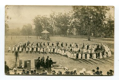 Orbost & District Historical Society
black and photograph / postcard, first half 20th century
There is no information available with this item. The photograph was possibly taken at the old showground in Orbost and may be associated with a church function. It may have been taken at a sports ground or at a race meeting. The rotunda may be a judge's stand.A black / white photograph / postcard. There is a large group of children girls in white dresses which have sashes or garlands. They are partnered with boys in suits. They are in a paddock in formation. There is an audience of mostly men watching them. In the right front is a group of men, wearing turbans, who appear to be Sikhs. In the background is a rotunda. there is a very faded indecipherable stamp on right side.children -
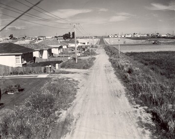 City of Kingston
Photograph - Black and white, c. 1960
This image depicts a scene of East Bentleigh in 1960, viewed along Thomasina Street as it crosses Gladwyn Street towards East Boundary Road in the distance. The gardens and new homes are well-tended, but the street surfacing is unsealed.Developing urban area now located within the City of Glen Eira, formally City of Moorabbin. This image illustrates the mid century urban sprawl of new suburbs and the subdivision of market gardens within the municipality and the changing demographic of the district as new houses are constructed and infrastructure established. Black and white photograph of unsealed road in new development in the area of Moorabbin, new houses appear on the lefthand side with paddocks on right side of image with installation of electric poles. Sealed road in the distance. Thomasina Street, as it crosses Gladwyn Street, East Bentleigh towards East Boundary Road. Handwritten in blue ink: 60 - 373 D Handwritten in red ink: 80% Handwritten in black ink: Ch. 6bentleigh, east bentleigh, market garden, housing, suburbs, infrastructure, moorabbin -
 Orbost & District Historical Society
black and white photograph, C 1880
This photograph shows Orbost's first cricket team in the Lochiel paddock - C 1880's.Included are: Alec Cameron; Harry Richardson; Jo Swallow; Matt Lynch; Joe Roderick; ? Hatton; Alf Richardson; Janes Cameron; John Cameron;John FarquharSport is often regarded as an important part of life in rural Australia. Cricket is one of the most popular sports in Australia at international, domestic and local levels. It has been played in Australia for more than 200 years. This photograph is a pictorial record of an Orbost cricket team in the nineteenth century.A black / white photograph of a group of men standing in front of a cricket pitch. Two men are holding cricket bats and are wearing pads. One man is crouching.sport-cricket recreation-cricket -
 Whitehorse Historical Society Inc.
Photograph, Smithy's Shed, 1996
The Blacksmith's shop or 'Smithy' was erected from timbers found in a paddock in the Dandenong Ranges by Mr George Cox which were transported to the Cottage site and re-erected in 1970 on a part of the site where remains of a previous building had been found.Coloured photo of Blacksmith's Shedblacksmith, smithy, schwerkolt cottage -
 Whitehorse Historical Society Inc.
Photograph, Schwerkolt Cottage
The Blacksmith's shop or 'Smithy' was erected from timbers found in a paddock in the Dandenong Ranges by Mr George Cox which were transported to the Cottage site and re-erected in 1970 on a part of the site where remains of a previous building had been found.Black and white photo of Smokehouse and Smithy at Schwerkolt Cottageschwerkolt cottage, smokehouse, smithy, blacksmith forge -
 Whitehorse Historical Society Inc.
Photograph, Schwerkolt Cottage, 1973
The Blacksmith's shop or 'Smithy' was erected from timbers found in a paddock in the Dandenong Ranges by Mr George Cox which were transported to the Cottage site and re-erected in 1970 on a part of the site where remains of a previous building had been found.Black and white photo of Blacksmith's shop at Schwerkolt Cottageschwerkolt cottage, smithy, blacksmith's -
 Hume City Civic Collection
Photograph, Emu Bottom Homestead
The photograph was taken from the rear of the Emu Bottom Homestead and its outbuildings in front of the home paddock. George Evans, one of the district's earliest European settlers built the original homestead from Silurian sandstone removed from the surrounding hillsides in the 1830s.A black and white landscape photograph with a cream border of a farm house and outbuildingsemu bottom homestead, homesteads, george evans, jackson creek, sunbury -
 Bendigo Historical Society Inc.
Book - STRAUCH COLLECTION: A HISTORY OF HOLY TRINITY BENDIGO
Initially set up as an outreach mission church of St Paul's, Bendigo, to serve the outlying paddocks and farms of the Flora Hill area. The church was originally built on the corner of Hallam and Somerville streets in 1904. In 1972 it moved to a new church built in Keck Street.A History Of Holy Trinity Bendigo A Spiritual Home.Keith Colebook, bendigo, church -
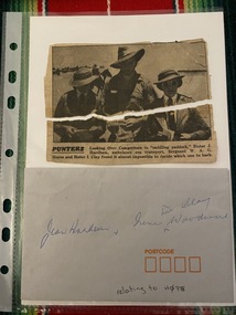 Returned Nurses RSL Sub-branch
Ephemera - Envelope & two pieces torn newspaper clipping, Punters
Envelope & newspaper clipping with photograph with caption 'PUNTERS Looking Over Competitors in "saddling paddock," Sister J. Harham, ambulance sea transport, Sergeant W. A. G. Heyes and Sister I. Clay found it almost impossible to decide which one to back.'Small envelope and torn newspaper clipping'Jean Hardham & Irene ^ nee Clay Woodward' 'relating to H078' [on envelope]sister j hardham, sergeant w a g heyes, sister i clay -
Glenelg Shire Council Cultural Collection
Photograph - Photograph - Bridge, n.d
Sourced from Casterton Town Hall (former Shire of Glenelg)Coloured photograph. Same as 7302 7302 - Coloured photograph. Unmade road between paddocks. Photo taken close to bridge with wooden railings. Erosion of creek sides can be seen. Sign at bridge ' Bridge Load Limit 5 t gross'? Same bridge as 7301, taken at different time. -
 Tatura Irrigation & Wartime Camps Museum
Painting - Painting - Water Colour, Lagerbild Germalt von Glunkler
The painting is of Camp 3 painted by internee Glunkler.Water colour of two huts with the windows open. Another hut is partially in the picture. An item of washing is hanging on a clothes line between two of the huts. A garden of red flowers in is the foreground and two gum tree are in the paddock behind a wire fence. Wooden frame behind glass with dark green matt.Glunkler 1942glunkler, camp 3, huts, watercolour -
University of Melbourne, Burnley Campus Archives
Plan, Alton-Hascombe Feature Survey, c. 1990
1 tracing paper and 2 paper copies of plan by Department of Conservation, Forests and Lands, Division of Survey and Mapping, of adjoining gardens Alton and Hascombe at Mount Macedon, Victoria. Scale 1:1000. Plan of properties includes buildings, gardens and paddocks. 1 copy has significant buildings coloured.feature survey, mount macedon, gardens, alton, hascombe -
Glenelg Shire Council Cultural Collection
Photograph - Contact Print - Portland, Victoria, 1970s
Set of 3 pairs of stereoscopic contact prints from glass plate negatives. Top: View from hill overlooking homestead and outbuildings. Middle: paddocks, fence, sheep run. Bottom: View from south side Cliff Street - looking north along Bentinck Street railway cutting to station.portland scene, bentinck street, street scene, photography -
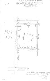 Ringwood and District Historical Society
Document - Copy of Lands Department Field Notes - Parish of Ringwood, Victoria, Field Notes 1917/137 - Part of O.P. R72 - Allotment 10, surveyed June 1917
5613b Foolscap size photocopy of survey map with handwritten notations. References include Knight's land, Wantirna Road, Canterbury Road, house, wirenetted, orchard, grass paddock, I certify that these notes are a true copy of observations and measurements taken on the ground by me (signed) H.W. Moore 5/6/17. -
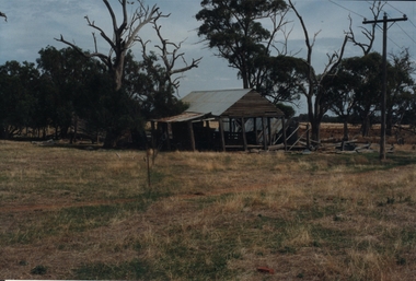 Bendigo Historical Society Inc.
Photograph - ROY J MITCHELL COLLECTION: FARM SHED
Colour photograph of dilapidated farm shed near Goornong. Shed appears to be a shelter, open underneath with corrugated iron roof. Trees behind, grass paddock in foreground. Written on back ' 29.3.96 near Goornong vict 14.30 hours, Shepparton-Bendigo Road, near Goornong. By Roy J Mitchell Bendigo.'agriculture, farm, shed -
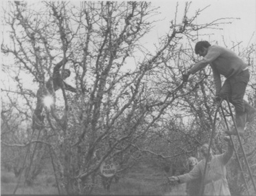 University of Melbourne, Burnley Campus Archives
Photograph - Black and white prints, Student Activities, Unknown
Collection of black and white photographs taken by an unidentified student showing various activities. Those scanned are: (2) Students pruning fruit trees. (4) Students propagating in a glass house. (11) Member of staff in the Orchard. (16) Students in the Bull Paddock with Dairy in the background. (21) Students in the Plant Science Laboratory.student activities, students, pruning, fruit trees, propagating, glasshouses, staff, orchards, bull paddock, dairy, plant science laboratory -
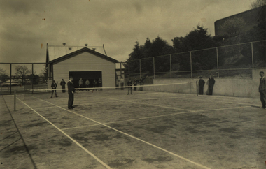 Federation University Historical Collection
Photograph - Photograph - Black and White, Richards & Co, Ballarat Junior Technical School Tennis Court - 1956, 1956
When Ballarat Junior Technical School building was opened in 1921, there was little cleared space for the students to use for sporting activities. The area known as Battery Paddock was used for dodge-ball and football. Gradually the slope area was cleared and planted. In November 1922 a tennis court was opened in the Battery Paddock. It was designed and built by two former students of the Ballarat School of Mines. The old Mount Doran school house was moved to the area as a students' common room. A new tennis court was built in the same vicinity in 1934. This area was on the corner of Grant and Albert Streets. Area is where the Corbould Building and the Automotive Skills Centre of School of Mines Ballarat Grant Street Campus now stand. Black and white photograph of the tennis court built in 1934 at Ballarat Junior Technical School. Gaol wall to the left and the old Mount Doran school house that was moved to the school grounds in 1922 and used as a Students' common room. Four students playing tennis with others watching.Stamp on back indicating photographer - "Richards & Co - Ballarat"ballarat junior technical school, student, 1921, battery paddock, ballarat school of mines, ballarat school of mines tennis court, mount doran, students' common room, 1934, grant street, albert street, corbould building, automotive skills centre, student activities