Showing 16209 items
matching community
-
 Greensborough Historical Society
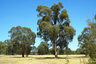
Photograph - Digital image, Marilyn Smith et al, Janefield Precinct: Looking toward grave area from camp, 27/11/2014
Janefield Precinct: Looking toward grave area from camp. The remains of this site are between Greensborough and Janefield. A RAAF Hygiene Training Camp was located on the Plenty River, just south of the Janefield community. It was in use from 1944 to 1946. The Camp was constructed from salvaged materials. Instruction included building and maintenance of grease traps, latrines, elementary plumbing and carpentry.Early remains of a WW2 training camp Digital colour photograph. -
 Greensborough Historical Society
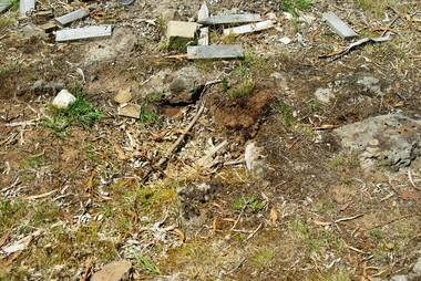
Photograph - Digital image, Marilyn Smith et al, Janefield Precinct: Cut Bluestone blocks from old building, 27/11/2014
Janefield Precinct: Cut Bluestone blocks from old building. The remains of this site are between Greensborough and Janefield. A RAAF Hygiene Training Camp was located on the Plenty River, just south of the Janefield community. It was in use from 1944 to 1946. The Camp was constructed from salvaged materials. Instruction included building and maintenance of grease traps, latrines, elementary plumbing and carpentry.Early remains of a WW2 training camp Digital colour photograph. -
 Greensborough Historical Society
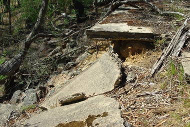
Photograph - Digital image, Marilyn Smith et al, Janefield Precinct: Decaying slabs near edge of cliff, 27/11/2014
Janefield Precinct: Decaying slabs near edge of cliff. The remains of this site are between Greensborough and Janefield. A RAAF Hygiene Training Camp was located on the Plenty River, just south of the Janefield community. It was in use from 1944 to 1946. The Camp was constructed from salvaged materials. Instruction included building and maintenance of grease traps, latrines, elementary plumbing and carpentry.Early remains of a WW2 training camp Digital colour photograph. -
 Greensborough Historical Society
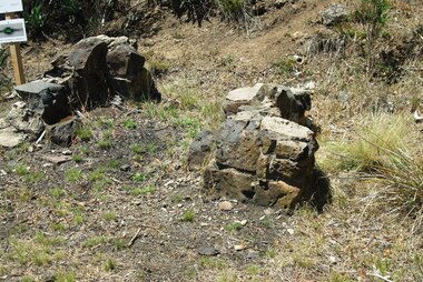
Photograph - Digital image, Marilyn Smith et al, Janefield Precinct: Old fire place on lower terrace, 27/11/2014
Janefield Precinct: Old fire place on lower terrace. The remains of this site are between Greensborough and Janefield. A RAAF Hygiene Training Camp was located on the Plenty River, just south of the Janefield community. It was in use from 1944 to 1946. The Camp was constructed from salvaged materials. Instruction included building and maintenance of grease traps, latrines, elementary plumbing and carpentry.Early remains of a WW2 training camp 2 Digital colour photographs. -
 Greensborough Historical Society
Photograph - Digital image, Marilyn Smith et al, Janefield Precinct: Outside building next to admin block, 27/11/2014
Janefield Precinct: Outside building next to admin block. The remains of this site are between Greensborough and Janefield. A RAAF Hygiene Training Camp was located on the Plenty River, just south of the Janefield community. It was in use from 1944 to 1946. The Camp was constructed from salvaged materials. Instruction included building and maintenance of grease traps, latrines, elementary plumbing and carpentry.Early remains of a WW2 training camp Digital colour photograph. -
 Greensborough Historical Society
Photograph - Digital image, Marilyn Smith et al, Janefield Precinct: World War 2 era concrete and guttering, 27/11/2014
Janefield Precinct: World War 2 era concrete and guttering. The remains of this site are between Greensborough and Janefield. A RAAF Hygiene Training Camp was located on the Plenty River, just south of the Janefield community. It was in use from 1944 to 1946. The Camp was constructed from salvaged materials. Instruction included building and maintenance of grease traps, latrines, elementary plumbing and carpentry.Early remains of a WW2 training camp Digital colour photograph.janefield -
 Eltham District Historical Society Inc
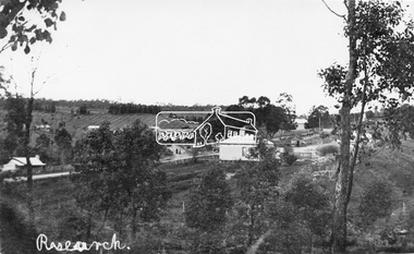
Negative - Photograph, Tom Prior, View of Research, Vic, c.1900
View of Research looking down Ingrams Road towards the rear of Doney's store, Main Road left to right. General Store centre. Ingrams Road opposite General Store. Hotel right of centre. The small building at left of photo housed the school for a short period of time but it was too hot in summer and the community lobbied for a more substantial school.This photo forms part of a collection of photographs gathered by the Shire of Eltham for their centenary project book,"Pioneers and Painters: 100 years of the Shire of Eltham" by Alan Marshall (1971). The collection of over 500 images is held in partnership between Eltham District Historical Society and Yarra Plenty Regional Library (Eltham Library) and is now formally known as the 'The Shire of Eltham Pioneers Photograph Collection.' It is significant in being the first community sourced collection representing the places and people of the Shire's first one hundred years. The Reynolds family were early settlers in Research. The Reynolds/ Prior collection of photographs were taken by Tom Prior, the maternal uncle of Ivy Reynolds, around 1900 and the 60 photos in the album give a fine overview of many of the landmarks of Research and Eltham over 100 years ago. lvy lived in the family home for many years at 106 Thompson Cres Research. Ivy's father, Ernst Richard Reynolds and grandfather, Richard Reynolds, lived at the same address. Ivy's father Richard worked for Mr. Trail on his property in Research. Reynolds Road is named after the family. Mr Tom Prior (wife Eva) worked at the Melbourne zoo. He was very innovative and made his own camera, using the black cloth hood to exclude the light. The photographs are a reminder of the rural nature of Research and Eltham and its rich heritage.Digital image 120 format B&W negativesepp, shire of eltham pioneers photograph collection, research (vic.), general store, ingrams road, main road, research hotel, doney property, research primary school, reynolds prior collection -
 Orbost & District Historical Society
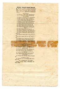
programe, 1888
Local land boards were community based "tribunals" consisting of a chairman appointed by the the state government and two(?) local members who were there or their knowledge of local land management practices. These boards were establishe in the mid-late 19th century and generally dealt with disputes about fencing, water rights, general land enquiries and the opening or closing of local roads.This document is a record of local land issues in the late 19th century. A sheet of paper, held together with sticky tape, stating the names of cases to be read by court regarding land. document land-use land-board gregson -
 Australian National Surfing Museum
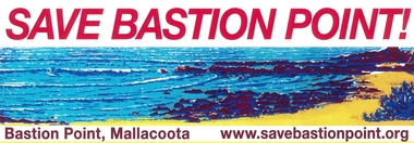
Sticker, SAVE BASTION POINT, Circa 2010
This colour sticker was produced and distributed Australia wide by the SAVE BASTION POINT CAMPAIGN to support their environmental campaign to stop a breakwall being built across the popular surf break - Bastion Point in Mallacoota, Victoria, Australia. The breakwall is supported by the local fishing community and local council. If built it would destroy one of the most popular surf breaks in East Gippsland.This sticker represents a local environmental campaign which has gained state and national attention. Full colour gloss car sticker featuring graphic artwork of Bastion Point and the website for the SAVE BASTION POINT campaign (based in Mallacoota, Victoria, Australia)Web address - www.savebastionpoint.orgsurf, bastion point, mallacoota, breakwall, surfrider foundation, east gippsland, save bastion point -
 Glen Eira Historical Society
Letter - Glen Huntly Road, Elsternwick
Ten documents concerning the redevelopment of 543-555 Glenhuntly Rd., Elsternwick in the early 1980s by B. P. Food Plus to create a 24 hour drive-in convenience store. Includes newspaper articles and correspondence from local residents, small business and community groups stating their objections and concerns. Also a report by the MMBW, 1982, on the development of guidelines for such shops.town planning appeals tribunal, de silva m., de silva m. a., b. p. australia ltd., city of caulfield, riley john, buckner john, wright h. mcm., cook r., burleigh brian, caulfield progress association, wilson lawrence john, murphy barry oliver, messrs. whiting and byrne solicitors, messers t. j. mulvaney co., mckimm russell, robinson g. a., watt h. w., kinder alan, commercial development, white o. a., van hoon joan, van hoon john, smith p., ben s. g., lee g. b., gibbs les, brennan h. p., pretty f. w., rasmussen l., orchard a. r., lopek m., carpenter mrs., pearce mrs., mcgrowan e., owens p., brawn j. e., harron g., brittingham w. c., lindsey m., de silva s., horton mary, james m., walker e., bennett h. l., riley s., b. p. food plus, coltex, glen huntly rd., hopetoun gardens, pickerd c. w., doolan g. n. (cr), the retail confectionary and mixed business association, town planning, land values, peak susan, white ted, ingleby june, elsternwick chamber of commerce, moore h. r., melbourne metropolitan board of works, ‘convenience premises and convenience shops report and guidelines’, legal documents, hawthorn road, petitions, north road, petrol stations, hopetoun hospital, foster street, winton hall (special accommodation home), caulfield council, resident action, murray street, councils -
Glen Eira Historical Society
Document - CHURCH OF CHRIST, NORTH ROAD AND ARNOTT STREET, ORMOND
This file contains 3 items: 1/A program for the 50th anniversary of Ormond Church of Christ dated 29/06/1975. 2/A Diamond Jubilee book for Ormond Church of Christ dated 23/06/1985. 3/A 75 years of witness book of Ormond Community Church of Christ from 1925-2000. It chronicles the church’s activities and progress by year.ormond, ormond church of christ, henrichsen e.c., hutchings brother, hutchings sister, lyall r., pratt c., lintott brother, lumley brother, ring brother, tuck brother, blair sister, olliver sister, ring sister, tuck sister, goddard elsie, hanaker sister, bowen-jones sister, kershaw brother, kershaw sister, merrin r. brother, moore sister, mcclelland i. brother, mcclelland i. sister, nesbit brother, oliver brother, oliver sister, oliver p. sister, paynter j. sister, ring sister, ring minnie, ring reynold, ring robbie, richards sister, small sister, smedley sister, scott brother, scott sister, taylor sister, telfer brother, telfer sister, theyer mrs., theyer miss., yewdall v., yewdall f., linttot mrs., lumley mr., ring mr., tuck mr., blair mrs., oliver mrs., ring mrs., tuck mrs., yewdall mrs., mcclelland mr., yewdall mr., thomson w.j., kershaw mr., taylor mr., mcclelland mrs., oliver mr., pioneers, ring mrs., veal mrs., oliver mrs., smail mrs., brown mrs., yates mrs., lumley mrs., knight mrs., hannaker mrs., hooper miss, merrin mrs., tuck mrs., smith mrs., henry mrs., bartlett mrs., johnson mrs., vautier mrs., mulroney mrs., bethany nursery school, murrumbeena, oakleigh, ward clive, henry edna, weaver edna, moorabbin hospital, north road, bambra road, mckenzie r., cole g., ghys p., jacques b., kay d., knee b., streader c., kilgour p., stibbe g.o., cannon p.r., hunt a., stibbe b., crittle w., yewdall sister, yewdall brother, mcclelland brother, thomson w.j. brother, taylor brother, brown sister, bartlett sister, hannaker sister, henry sister, hooper sister, johnson sister, knight sister, lumley sister, merrin sister, mclelland sister, smail sister, smith sister, theyer sister, meyer sister, veal sister, yates sister, clay w.h., clay l., withers a.b., baker s.r., andrews g.j., mcnaughton k.a., lang c.l., mcdowell w.w., martin j.k., vautier r.w., buckingham f.e., mansell d.w., randall e.h., garros n., mckenzie r.c., barker l.f., mathieson g.w., clayden c.p., cole brother, keneley brother, knee brother, alabaster brother, hood brother, hunt brother, kay brother, kilgour brother, manson brother, parker brother, towns brother, canns sister, houzego sister, grant sister, keneley sister, knee sister, mulroney sister, mcmillan sister, streader sister, young sister, hunt sister, whittaker brother, ennor sister, manson sister, ryall brother, alabaster j., beazley f., whittaker b., flanders g., north l., skews n., cole p., knee i., beazley bev., bradley n.w., cole d., keneley r., alabaster r., hood h., kay j., knee a.j., wannan john, wannan jennifer, arnott street, walsh street, hutchings mr., hutchings mrs., andrews sister, burton may, briggs b., bevan sister, brown brother, fisher brother, faragher l., streader d., mcdonald i., mcmillan d., cannon p., cannon h., mcquatter s., mcqualter s., kwong d., wittick r., mcdonald a., w.a. o’donnell pty ltd., williams louis r., henrichsen e.c., mayor of caulfield, shaw h.h., shaw w.g., drayton r., killmier e.r., stibbe glen, stibbe betty, stibbe ian, stibbe michelle, nicholls road, cannon peter, cannon helen, randall e.r., westwood j., langford f., white a.e., williams e.l., jones a.r., gray m., heath b., mullen i., van lean a., holt r., stevens d., fechner k., leake k., tippet i., tunks b., wilson d., bannon g., alabaster r.l., bishop j., faragher m., hunt l., reeves o., swankie m., cann b., ennor e., roper j., nash n., ryall d., kappa sigma pi, phi beta pi, clubs and associations, bethany close, webb j.e., lang c.l., skewes home, claire street, mckinnon, bethany nursing school, bentleigh east, j. bond and timms mission, thorpe jack, ormond station, ormond railway station, avery allan, aurelia, langford frank, drayton r., moorabbin town hall, hunt lindsay, whittaker john, deuble greg, gauson bill, beavis colin, pell norman, mansell david, niven alan, ormond road, ormond community church of christ, risson anthony, risson bronwyn, avery allan, avery liliane, cannon p.r., adamson m., bainbridge b., larkham j., moore j., bauer p., longmuir p., dodd m., uldrich m., thistlewaite a., english c., avery a., risson a., westwood t., langford f., white a.e., williams e.l., jones a.r., gray m., heath b., mullen i., van lean a., holt r., stevens d., fechner k., leake k., tippet i., tunks b., wilson d., bannon g., religious structures and establishments, religious groups, church groups, congregations (religious), monuments and memorials, clergy, baptisms, funerals, choirs, church festivals, rites and ceremonies, festivals and celebrations, paralysis epidemic, organs, manses -
 Hume City Civic Collection
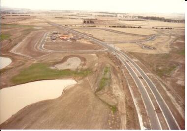
Photograph, c 1978
On 4th August 1978 the construction of the Goonawarra Estate commenced. The estate was formerly known as the Goonawarra Farm and overlooked the Sunbury Township and the Jacksons Creek Valley. Plans for the development included a golf course, houses and community and recreational facilities. The golf course opened in 1980 and the housing construction continued throughout the last two decades of the twentieth century and into the twenty first century.A coloured aerial photograph of a display village area under construction. Two lakes are on the LHS of the photograph and Francis Boulevard is in the foreground and the middle distance.goonawarra golf club, goonawarra farm, goonawarra housing estate, housing developments, sharkey, robert b., kilkenny homes, australian ideas homes pty.ltd., glamor homes, craftsmen homes., villa bella homes, george evans collection -
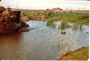 Hume City Civic Collection
Photograph, c 1978
On 4th August 1978 the construction of the Goonawarra Estate commenced. The estate was formerly known as the Goonawarra Farm and overlooked the Sunbury Township and the Jacksons Creek Valley. Plans for the development included a golf course, houses and community and recreational facilities. The golf course opened in 1980 and the housing construction continued throughout the last two decades of the twentieth century and into the twenty first century.A coloured photograph of the reflecting pool at the entrance of the Goonawarra Golf Club. The surrounding area has been landscaped and a display home is in the distance.goonawarra golf club, goonawarra farm, goonawarra housing estate, housing developments, sharkey, robert b., kilkenny homes, australian ideas homes pty.ltd., glamor homes, craftsmen homes., villa bella homes, george evans collection -
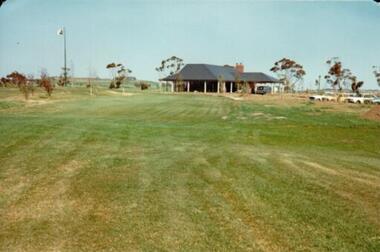 Hume City Civic Collection
Photograph, c 1978
On 4th August 1978 the construction of the Goonawarra Estate commenced. The estate was formerly known as the Goonawarra Farm and overlooked the Sunbury Township and the Jacksons Creek Valley. Plans for the development included a golf course, houses and community and recreational facilities. The golf course opened in 1980 and the housing construction continued throughout the last two decades of the twentieth century and into the twenty first century.A coloured photograph of the clubhouse at the Goonawarra Golf Course taken from the 10th fairway. Parked cars are visible on the RHS of the photograpg and there is a row of gum trees behind the clubhouse.goonawarra golf club, goonawarra farm, goonawarra housing estate, housing developments, sharkey, robert b., kilkenny homes, australian ideas homes pty.ltd., glamor homes, craftsmen homes., villa bella homes, george evans collection -
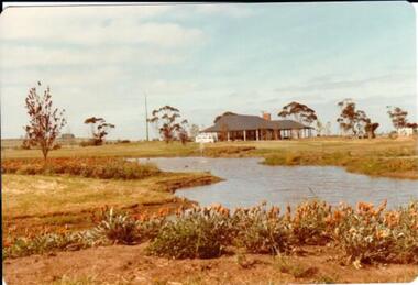 Hume City Civic Collection
Photograph, c 1978
On 4th August 1978 the construction of the Goonawarra Estate commenced. The estate was formerly known as the Goonawarra Farm and overlooked the Sunbury Township and the Jacksons Creek Valley. Plans for the development included a golf course, houses and community and recreational facilities. The golf course opened in 1980 and the housing construction continued throughout the last two decades of the twentieth century and into the twenty first century.A coloured photograph of the clubhouse at Goonawarra Golf Course as seen from the 10th green. A small white van is parked ouitside the building. There is a line of trees behind the clubhouse.goonawarra golf club, goonawarra farm, goonawarra housing estate, housing developments, sharkey, robert b., kilkenny homes, australian ideas homes pty.ltd., glamor homes, craftsmen homes., villa bella homes, george evans collection -
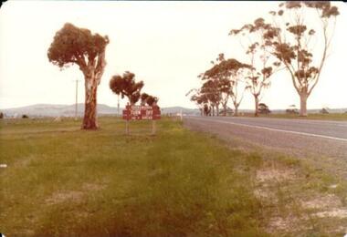 Hume City Civic Collection
Photograph, 1/08/1980
On 4th August 1978 the construction of the Goonawarra Estate commenced. The estate was formerly known as the Goonawarra Farm and overlooked the Sunbury town and the Jacksons Creek valley. Plans for the development included a golf course, houses, community and recreational facilities..The golf course opened in 1980 and the housing construction continued throughout the last two decadesd of the twentieth century and into the twenty firsat century.A coloured photograph showing the signpost indicating the entrance to the Goonawarra Estate from Sunbury Road. Trees are growing on either side of the road and Mt. Holden can be seen across the skyline.goona warra golf club, goonawarra farm, goonawarra housing estate, sharkey, robert b., kilkenny homes, australian ideas homes pty.ltd., craftsmen homes., glamor homes, villa bella homes, mt. holden, george evans collection -
 Stawell Historical Society Inc
Photograph, Brick Ticket Box at Central Park next to the former Dane House -- Coloured
This photo is another view of the brick Ticket Box (58.1) on the right side of main gates and next to the former Dane House. In 1999 the house was owned by Stawell City Council and used as the Community Neighborhood House. It was demolished some years ago. It was once the home of Misses Florence & Sophie Dane who moved to Queensland (taken from 1981 electoral roll). Photo of brick ticket box at Central Park to the right of main gate. The photo shows the ticket box beside a brick house. stawell central park -
 Moreland Turkish Association
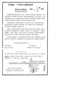
Flyer, Turk Islam Cemiyeti, Turk Toplumu Duyuru, 1974
This flyer in Turkish was printed by the Turkish Islamic Society to advertise an event celebrating the 51st anniversary of the establishment of the Turkish republic. The program for the evening included patriotic songs, poems and traditional music and dance as well as a 3 act play entitled 'Yetis Kemal'. This type of event was regularly held by the Turkish Islamic Society in the early years of the settlement of the Turkish community in Melbourne. This flyer is of social significance and demonstrates a stage of settlement of Melbourne's Turkish community.One page flyer, printed on cream paper in black.migration, turkey, islam -
 Whitehorse Historical Society Inc.
Photograph, Basketball Stadium, East Burwood
The East Burwood stadium was opened on the 24th July 1970 by Victorian Premier, Dick Hamer. It was the most famous basketball venue in the 70's and 80's costing $8 million. The stadium was financed by basketball patrons under administration of the Nunawading Basketball Association, a non-profit community advancement company. The stadium caters for 7000 players per week.Coloured photograph of the basketball stadium East Burwood. Cars parked at the front. The East Burwood hall in the distance. Located in Burwood Hwy East Burwood.basketball stadium, east burwood, sporting venue -
 Mt Dandenong & District Historical Society Inc.
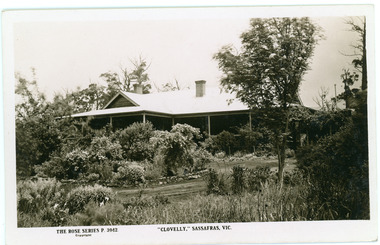
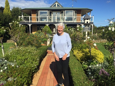
Photograph, Clovelly, c1920s
Clovelly Guest House was formerly Braco Park Guest House, owned and run by Eliza and Grace Murdoch. The original Guest House 'Clovelly' , owned by Mrs. Techow, was situated in The Crescent at Sassafras. After it burned down in 1921, Mrs. Techow purchased Braco Park and renamed it Clovelly. The site was purchased by the Education Department c1985 and is now Sherbrooke Community School. B & W Rose Series Postcard showing Front/Side view of Clovelly Guest House (formerly Braco Park) in Sassafras.The Rose Series P. 3942. "CLOVELLY" SASSAFRAS, VICclovelly, techow, murdoch, braco park, sherbrooke community school, guest house -
 Whittlesea Historical Society Inc.
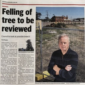
Newspaper - Newspaper clipping, Whittlesea Leader, Felling of tree to be reviewed, 3 Oct 2017
Published Whittlesea Leader, 3 Oct 2017. Felling of tree to be reviewed. A much loved 300 year-old gum tree was cut down from the corner of Bridge Inn and Plenty roads, Mernda, to make way for the Mernda Town Centre development. Many in the community loved this tree as it was a local landmark that stood on the corner of the former Cockerell's Forge.Newsprintwhittlesea leader, cockerell, gum tree, mernda, cockerell forge, mernda blacksmith -
 Otway Districts Historical Society
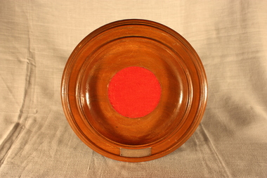
Plate, Les Flegg, Collection Plate, 1957
Mrs Mabel Olive Hobson (nee Nichols, b. 1895), owner of Cavan House, a guest house, in Lavers Hill, was a valuable community member who did a lot around district. When she died in Colac in 1957 a memorial collection plate inscribed with her details was given to the Presbyterian Church in Lavers Hill. The Church was built in the early 1900s.Wooden circular bowl, two lips around the outer edge, with red felt in centre, 54mm steel inscription. On verso, raised lip with red felt insert in centre. "In Loving Memory of Mrs Mable Hobson November 12th 1957"lavers hill; presbyterian church; mabel hobson; -
 Apollo Bay Museum
Audio - Bill Hurley Fraser Oral History Interview Apollo Bay May 2023
Local Otways residents (Gadubanud Country) were interviewed by artist/researcher Amy Tsilemanis for the 2023 storytelling project Heart Maps, a collaboration with the Apollo Bay Museum and Historical Society. Themes include memories of communication technologies, entertainments, school, work, community, and life near the ocean. More information here: https://amytsilemanis.com.au/portfolio/heart-mapsapollo bay, fishing, seafood -
 Apollo Bay Museum
Audio - Russell Frost Oral History Interview, Apollo Bay, April 2023
Local Otways residents (Gadubanud Country) were interviewed by artist/researcher Amy Tsilemanis for the 2023 storytelling project Heart Maps, a collaboration with the Apollo Bay Museum and Historical Society. Themes include memories of communication technologies, entertainments, school, work, community, and life near the ocean. More information here: https://amytsilemanis.com.au/portfolio/heart-mapsapollo bay, fishing, seafood -
 Apollo Bay Museum
Audio - Val Flitton Oral History Interview Apollo Bay April 2023
Local Otways residents (Gadubanud Country) were interviewed by artist/researcher Amy Tsilemanis for the 2023 storytelling project Heart Maps, a collaboration with the Apollo Bay Museum and Historical Society. Themes include memories of communication technologies, entertainments, school, work, community, and life near the ocean. More information here: https://amytsilemanis.com.au/portfolio/heart-mapsapollo bay, nursing, ww2 -
 Apollo Bay Museum
Audio - Nellie O'Meara Oral History Interview Apollo Bay April 2023
Local Otways residents (Gadubanud Country) were interviewed by artist/researcher Amy Tsilemanis for the 2023 storytelling project Heart Maps, a collaboration with the Apollo Bay Museum and Historical Society. Themes include memories of communication technologies, entertainments, school, work, community, and life near the ocean. More information here: https://amytsilemanis.com.au/portfolio/heart-mapsapollo bay, tourism -
 Apollo Bay Museum
Audio - Irene Newton Oral History Interview Apollo Bay May 2023
Local Otways residents (Gadubanud Country) were interviewed by artist/researcher Amy Tsilemanis for the 2023 storytelling project Heart Maps, a collaboration with the Apollo Bay Museum and Historical Society. Themes include memories of communication technologies, entertainments, school, work, community, and life near the ocean. More information here: https://amytsilemanis.com.au/portfolio/heart-mapsapollo bay -
 Apollo Bay Museum
Audio - John Marriner Oral History, Apollo Bay April 2023
Local Otways residents (Gadubanud Country) were interviewed by artist/researcher Amy Tsilemanis for the 2023 storytelling project Heart Maps, a collaboration with the Apollo Bay Museum and Historical Society. Themes include memories of communication technologies, entertainments, school, work, community, and life near the ocean. More information here: https://amytsilemanis.com.au/portfolio/heart-mapsapollo bay, hordern vale -
 Apollo Bay Museum
Audio - Val Cameron Oral History, Apollo Bay April 2023
Local Otways residents (Gadubanud Country) were interviewed by artist/researcher Amy Tsilemanis for the 2023 storytelling project Heart Maps, a collaboration with the Apollo Bay Museum and Historical Society. Themes include memories of communication technologies, entertainments, school, work, community, and life near the ocean. More information here: https://amytsilemanis.com.au/portfolio/heart-mapsapollo bay, hospital, nursing -
 Apollo Bay Museum
Audio - Olive and Gordon Currie Oral History, Apollo Bay April 2023
Local Otways residents (Gadubanud Country) were interviewed by artist/researcher Amy Tsilemanis for the 2023 storytelling project Heart Maps, a collaboration with the Apollo Bay Museum and Historical Society. Themes include memories of communication technologies, entertainments, school, work, community, and life near the ocean. More information here: https://amytsilemanis.com.au/portfolio/heart-mapsapollo bay, farming, killala rd