Showing 8870 items matching " construction"
-
 Ballarat Tramway Museum
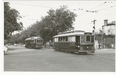
Photograph - Black & White Photograph/s, Lloyd Rogers, 21/03/1962 12:00:00 AM
Yields information about the appearance of Hospital Corner in the early 1960's and trams that used the area.Black and white photograph of Ballarat tram No. 30 followed by No. 34 leaving Drummond St south and crossing Sturt St, Hospital corner. No. 30 has the destination of City and No. 34, Lydiard St North. In the background is the construction of the liquor store on the south west corner by J Wier. Dated 21/3/1962. Printed on Agfa Gevaert paper in a postcard format. In the front of No. 30 can be seen a child hanging onto the door and pillar. No. 34 has SEC Electricity cooking advertisement. Photo by Lloyd Rogers.In ink "Ballarat Cars 30 and 34 entering Sturt St from Sebastopol route. 21/3/1962. and the number "4/43". In the top left hand corner "30 ex M?"trams, tramways, sturt st, drummond st sth, hospital corner, passengers, tram 30, tram 34 -
 Bendigo Historical Society Inc.
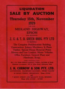
Document - IAN DYETT COLLECTION: AUCTION CATALOGUE - Z C & T D GREEN BROS PTY LTD
Light red covered auction catalogue for a sale on the 15th November 1979 of Z. C. & T. D. Green Bros. Pty Ltd of Complete Prefabrication Building Construction, Joinery Machinery & Plant, Timber, Special House Removal Prime Movers and Low Loaders, Motor Vehicles, Office Furniture, General Plant and Hardware and Scrap Under Instruction from: Mr. J. M. Walsh (Official Liquidator), Wallace, McMullin & Smail. J. H. Curnow & Son Pty Ltd were the auctioneersbusiness, auctioneers, j h curnow & son pty ltd, ian dyett collection - auction catalogue - z c & t d green bros pty ltd, mr j m walsh, wallace mcmullin & smail, j h curnow & son pty ltd, f c dyett, i m dyett, bolton bros print -
 Kew Historical Society Inc
Archive (Sub-series) - Subject File, 'Fairview', 34 Wrixon Street (Kew), 1979
Various partiesReference, Research, InformationSecondary Values (KHS Imposed Order)Subject file containing information about Fairview (built 1924 for F.F. Robinson, proprietor of Yarra Falls Mills). The house replaced an earlier single-storey brick house, also called Fairview. A comprehensive report prepared by Alan Willingham in 2006 found that there was no evidence that the architect Desbrowe-Annear incorporated parts of the original building in the new construction. The work by Willingham is a ‘Cultural and Architectural History and Assessment of the Cultural Heritage Significance’ of the building, prepared for Carey Grammar School. The Willingham report was donated by Sr Ruth Anderson.kew (vic) - history, fairview - 34 wrixon street - kew (vic), cluny house - 34 wrixon street - kew (vic), f.f. robinson, alan willingham, harold desbrowe-annearkew (vic) - history, fairview - 34 wrixon street - kew (vic), cluny house - 34 wrixon street - kew (vic), f.f. robinson, alan willingham, harold desbrowe-annear -
 Tennis Australia
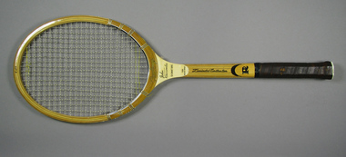
Racquet, Circa 1974
A Rawlings, John Newcombe Signature tennis racquet, with ribbon whipping around shoulders, and mottled leather handle grip. Rawlings logo features across base of head. Model name features across throat. Inscription: LAMINATED CONSTRUCTION features along shaft. Black Rawlings 'R' trademark features on lower shaft. Red, white and black 'R' trademark features in sunken butt cap. Materials: Wood, Nylon, Ink, Glue, Lacquer, Metal, Ribbon, Adhesive tape, Paint, Leather, Plastic, Bambootennis -
 Kew Historical Society Inc
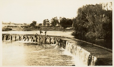
Photograph - Victorian Canoe Club, Dight's Falls, Studley Park, 1920-30
Canoeing on the River Yarra at Melbourne was an important and widespread recreational pursuit for Melbournians, especially in the first half of the twentieth century. The Victorian Canoe Club was formed in 1912 at a meeting in Melbourne and its first committee elected in the same year. Records indicate that the Club continued into at least the 1950s .The album has historic and social significance as a record of recreational activities (as well as canoe making) in the early years of the twentieth century. It has local significance as the site of the headquarters of the Club was in Studley Park. A number of photographs in the album provide vistas of Kew on the Yarra that are otherwise unavailable.One of 24 labelled photos in part album, originating from the Victorian Canoe Club, which had its headquarters in Studley Park, Kew. The album includes a photographic record of canoe construction and also locations in Studley Park and Kew where the canoes were used. The subject of this photograph is identified as 'Dight's Falls, Studley Park'.The view shows an early trestle bridge across the Falls on which people, possibly members of the Club, are standing. The point of view would appear to be looking up river towards Fairfield."Dyghts Falls, Studley Park"victorian canoe club, river yarra, burke road -- kew (vic.), dight's falls -- fairfield (vic.), dight's falls -- kew (vic.), dight's falls -- yarra river -
City of Kingston
Photograph - Colour, c. 1993
Patterson Lakes is a suburb in the City of Kingston that is built one kilometre upstream of the mouth of the Patterson River. The area is bordered by the Patterson River and Eel Race Drain which enters the Kananook Creek. The suburb consists predominantly of newer housing developments and the tidal canal system of the development joins Port Phillip Bay.Patterson Lakes and the Kananook Creek were previously part of the extensive Carrum Carrum Swamp. The area was once a source of fish and eels for the Mayone-Bulluk clan of the Bunurong people. Over time the area was drained and in 1973 investigations commenced into the development of a unique residential area that would be built adjacent to canals and waterways. It was originally proposed to be known as "Gladesville". The development would give the suburb's homeowners access to Port Phillip Bay "from their back door". Circa 1974, the area was rezoned from rural to residential and named Patterson Lakes. Development has been continuous since the 1970s with construction of residential housing, schools, shopping centres, marinas, a hotel and library.Laminated colour aerial photograph of the Carrum and Patterson Lakes region within City of Kingston. This 1993 image includes Patterson River Secondary College, Roy Dore Reserve, Kananook Creek and Nepean Highway. The railway line can be seen as it veers inland from Eel Race Road, Seaford. The section of Palm Beach Drive, Curlew Point Drive, Snapper Point Drive, Clipper Island and Myola Street in Patterson Lakes appears to be a recent development with many spare blocks and new houses under construction.patterson lakes, seaford, kananook creek, carrum carrum swamp, canals and waterways -
City of Kingston
Photograph - Colour, 29 January 1993
Bonbeach, Carrum and Patterson Lakes are suburbs in the City of Kingston. Bonbeach and Carrum were holiday destinations in early 20th century and over time the housing has converted to permanent residential structures. In Patterson Lakes, the area consists predominantly of newer housing developments and the tidal canal system which is accessible to many dwellings joins Port Phillip Bay.Bonbeach, Carrum and Patterson Lakes were previously part of the extensive Carrum Carrum Swamp. The area was once a source of fish and eels for the Mayone-Bulluk clan of the Bunurong people. Over time the area was drained and this allowed farming at Carrum and Bonbeach, although the area was prone to flooding. In the early 1920s and 30s the land was converted to residential dwellings. In 1973 investigations commenced nearby to Bonbeach and Carrum into the development of a unique residential area comprising canals and waterways. It was originally proposed to be known as "Gladesville". Circa 1974, the area was rezoned from rural to residential and named Patterson Lakes. Development has been continuous since the 1970s with staged construction of the waterways, residential housing, and supporting infrastructure and facilities.Laminated colour aerial photograph of the Bonbeach, Carrum and Patterson Lakes region within City of Kingston. This 1993 image includes Bonbeach High School prior to demolition, Bonbeach Primary School and Patterson River Golf Club. Sections of Patterson Lakes are not yet developed, including Rhode and Staten Islands. Long Island Point appears to be a recent development with many spare blocks and new houses under construction. The Patterson River marina is prominent and the river mouth as it meets Port Phillip Bay. The Carrum railway station is visible.Black type on white adhesive sticker: No. 6661 Black type on white adhesive sticker: 26E/6661, 29/1/93, 4.25 pm Black type on white adhesive sticker 29-1-93 Yellow circular adhesive stickerbonbeach, carrum, patterson lakes, patterson river, carrum carrum swamp, canals and waterways -
 Bendigo Historical Society Inc.
Photograph - PETITION FOR BACK CREEK RESERVOIR
Petition sent in 1886 by the residents of Sandhurst to the Honourable James Sullivan Minister of mines in the colony of Victoria requesting the construction of a reservoir on back creek. The petition is on thirty-three photographs and is inside a quite well worn plain brown folder. On the front of the folder a stamp of the Royal Historical Society of Victoria Bendigo branch with the date:1960 and the number 217. Inside the cover in blue pen: donated by the Victoria Legislative through Mr. Galvin MLA and another RHSV stamp. The Mayor of Sandhurst at the time was John McIntyre.government, state, 1886 petition -
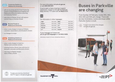 Melbourne Tram Museum
Pamphlet, Public Transport Victoria (PTV), "Buses in Parkville are changing", Feb. 2018
Pamphlet - 3 fold DL colour printed titled "Buses in Parkville are changing", advising of changes to routes 401, 402, 403,, 505 and 546 buses due to the construction of the Metro Tunnel station in Grattan Street from 18/2/2018. has a map showing the changed bus routes and tram routes. Parkville Station. Issued under the name of Transport for Victoria with a PTV web address. .1 - hanging pamphlet giving details of the proposed changes - cut to be hung on rails inside a bus.trams, tramways, buses, metro tunnel, grattan st, railways -
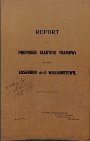 Melbourne Tram Museum
Document - Report, McCarty Underwood & Co, "Report on Proposed Electric Tramway between Essendon and Williamstown", 1914
Report - 16 foolscap pages, stapled into a brown cover report with a three part fold out map, glued into the rear cover, titled "Report on Proposed Electric Tramway between Essendon and Williamstown". Prepared by McCarty Underwood & Co. Consulting Engineers, August 1914. Details the route, estimate of construction costs, revenue, expenditure and engineer difficulties. Also reports on the use of Motor Buses and of Railless Electric Traction (Trolley Buses). Includes a detailed map showing the proposed route, existing cable and electric tramways.Has inked inscription on front cover "H. S. Dix Esq, compliments of F.O. McCarty"trams, tramways, new tramway, footscray, essendon, williamstown rd, trolley buses, buses -
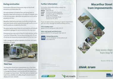 Melbourne Tram Museum
Pamphlet, VicRoads, "Macarthur Street tram improvements", Sep. 2011
Pamphlet, 3 fold DL, printed on gloss paper, titled "Macarthur Street tram improvements", giving details of the installation the installation of an "easy access" (Vienna style), for tram stop 11, routes 109 and 112. Issued Nov. 2011. Gives details of the project, how to use the stop, diagrams and artist views, arrangements for the tram stop during construction, the Think Tram project and contact details. Issued jointly by Yarra Trams and VicRoads. A photo features tram C3305 in Macarthur St. 2 copies held.trams, tramways, macarthur st, tram stops, vienna style stops, vicroads, disability services, tram c3005 -
 Melbourne Tram Museum
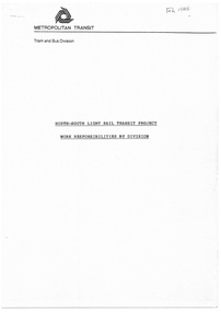
Document - Report, Metropolitan Transit Authority (MTA), "North South Light Rail Transit Project - Work Responsibilities by Division", 25/02/1986 12:00:00 AM
Report or Project plan - 5 A4 photocopied pages, were stapled in the top left hand corner, titled "North South Light Rail Transit Project - Work Responsibilities by Division". Produced by Metropolitan Transit Feb 1986, Tram and Bus division, gives a description of the light rail project to St Kilda and Port Melbourne conversion from rail to tram, which division would undertake which part of the project - MetRail or Tram and Bus, Property Group and Road Construction Authority or the Road Traffic Authority.In ink on the top right hand corner "Feb 1986"trams, tramways, the met, metropolitan transit, st kilda, port melbourne, light rail -
 Melbourne Tram Museum
Document - Memorandum, The Met, "W Class Tram Overhaul", Mar. 1989
Photocopy - report - of a The Met Memorandum dated 28 Oct. 1988 - 5 A4 Sheets stapled in the top left hand corner titled "W Class Tram Overhaul" from the Asset Development Co-ordinator to the Director, Engineering Maintenance and Construction. Memo looks at the concept of overhauling some 120 W class trams, project proposals, project need, alternatives, installation of AVM's, ticket machines, benefits, costs, compared to the cost of new trams, timing. Last sheet of the memo looks at the Preston Workshops capacity for such a project.written in ink on front cover "Includes comments on related PW Shop capacity for the overhauls"trams, tramways, w class, the met, preston workshops, overhauls -
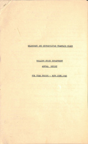 Melbourne Tram Museum
Document - Report, Melbourne & Metropolitan Tramways Board (MMTB), "Rolling Stock Department - Annual Report", Jul. 1940
Report - six foolscap sheets stapled in the top left hand corner enclosed by folder protective corner, titled "Rolling Stock Department - Annual Report for the year ending 30 June 1940". Gives details of the trams maintained and built, the workshops, running sheds, availability, buses, new buses, improvements to the rolling stock, defence work, work for other departments, foundry, laboratory, drawing office cable system and staffing. Last sheet details various classes available for service and those under construction.trams, tramways, workshops, staff, new trams, world war 2, buses -
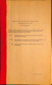
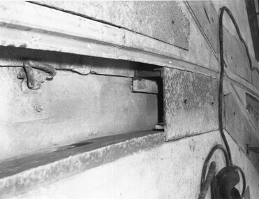 Melbourne Tram Museum
Photograph - Set of 5 Black & White Photograph/s, Melbourne & Metropolitan Tramways Board (MMTB), 1966
Series of 5 black and white photographs of the trackwork used at specific locations:\ .1 - plated curve of embedded plates for spandrel clips retaining the rails - would have allowed access. .2 - joint between rails - bridge expansion? In a temporary position. .3 - track being laid over a rail based bridge deck. .4 - track being laid or positioned for a bridge or replacement - possible slot beam and cable track in the background. .5 - temporary track over a bridge abutment or structure under construction.trams, tramways, trackwork, rails, track materials, track repairs, sleepers, equipment, bridges -
 Melbourne Tram Museum
Document - Report, Melbourne & Metropolitan Tramways Board (MMTB), 'Current trends which may indicate the future growth and nature of the metropolitan area and in particular the Central Business area of Melbourne", Jan. 1966
Report - Foolscap, card covers, red binding strip, about pages + drawings or charts, titled 'Current trends which may indicate the future growth and nature of the metropolitan area and in particular the Central Business area of Melbourne" Has three parts: 1 - Future growth of population of the Melbourne Metropolitan Area 2 - The Centre of Gravity of and general distribution of the Central Business area of Melbourne 3 - Future growth of the Central Business Area of Melbourne. Dated Jan 1966, prior to the construction of the Underground Railway and the move to Docklands.Has "JEC" in pencil on top right hand corner.trams, tramways, melbourne, planning, development -
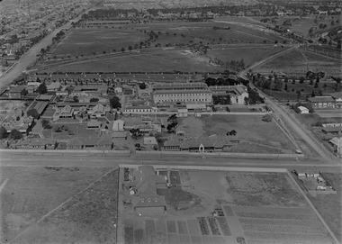 Melbourne Tram Museum
Photograph - Digital Image, Kevin O'Reilly, Royal Park looking east over the Royal Park Hospital, mid 1920's
Image from CD (Compact Diskette for use in computers) - see Reg Item 135. Image titled "Royal Park 2" on CD, of looking east over the Royal Park Hospital in the north west corner of the Royal Park itself. Has the West Coburg tram line in the photograph in the top quarter. The Royal Park railway station and cutting can be seen in the top right hand corner of the photograph. Possibly late 1920's given the construction of the Royal Park tram line was completed through the park in 1925.trams, tramways, royal park, west coburg -
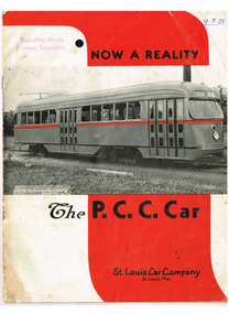 Melbourne Tram Museum
Pamphlet, St Louis Car Company Missouri, Now a Reality - The PCC car", late 1930's?
Sixteen (16) page booklet or pamphlet, centre stapled, black and white photographs with bold red overprinting in heading and company name. Produced by the St Louis Car Company Missouri. Gives the background to the Presidents Conference Committee (PCC) type streetcar or tramcar, St Louis Car Company involvement, has photos of the first car on the front cover (1001), photos of interior, drawings, doors, copy of letters dated 1936, details of structure, construction, PCC truck, body details, equipment and general dimensions.Has AETA stamp on front cover with the letters "4J31" in ink as well.trams, tramways, pcc, transport equipment, tramcars, usa -
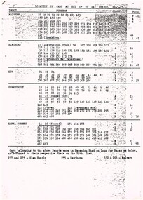 Melbourne Tram Museum
Administrative record - Depot List, Preston Workshops, "Allocation of Tramcars as at 26 March 1927", 1927
Photocopy onto an A4 sheet, two sheets, stapled in top left hand corner, titled "Location of cars at end of 28 Day Period 26-3-27", listing the class of trams allocated or allocation to each depot in Melbourne, including trams at Preston workshops, bodies under construction, W, X and Y class cars. Includes Coburg, Preston and Footscray. Shows depot allocation. Not known when copy made. 2nd copy added 14-5-2016 from the estate of Charles Craig.trams, tramways, preston workshops, lists, tramcars, lists, depots, depot allocation -
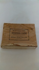 Kiewa Valley Historical Society
Photographs of small box originally used to contain sensitized photographic paper
The Junction Dam and Clover Dam Power Station, stages of the Kiewa Hydro-Electric Scheme, were needed to meet the increased power demands of the wartime industry in Victoria. Clover added 26 megawatts to the grid. Junction Dam was completed and ready to hold water by September 1943, but was emptied in December 1943 and not filled again until May 1944. Construction of Clover Power Station commenced in July 1941 and both turbines were in service by May 1945.Clover Power Station and Junction Dam were part of the Kiewa Hydro Electric Scheme constructed by the State Electricity Commission of Victoria. SECV official photographers took photographs of most stages of construction of the Hydro Electric Scheme and referenced each photo with a number and dating system as an historical record and for reference for other projects. This provided a thorough history of the construction of the Hydro Electric Scheme, some of the workers involved in its construction and the infrastructure supporting its construction, such a Bogong Village.Small light brown cardboard box originally containing sensitized photographic paper, now containing a range of black and white photographs of the Kiewa Hydro Electric System taken by the official SECV photographer Box has some damage – Front panel on lid is missing. Top has a puncture in top right corner and some peeling of paper along sides and at edges. Printed on the top of the box in black ink: OPEN ONLY IN PHOTOGRAPHIC DARK ROOM SENSITIZED PAPER Manufactured by – KODAK (A/asia) PTY. LTD. Melbourne Australia Green and white sticker on right side of lid and bottom right side of box, torn at join 1. 1B1 Single Weight Soft. Available in Soft (1) Medium (2) Contrast (3) Extra Contrast (4) Single and Double Weight Stamped at bottom of sticker in grey ink G8087 CK photographic paper box; state electricity commission of victoria; official photographer; kiewa hydro electric scheme; clover power station; junction dam; bogong village -
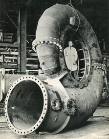 Kiewa Valley Historical Society
Photographs – SECV– Clover Power Station
The Junction Dam and Clover Dam Power Station, stages of the Kiewa Hydro-Electric Scheme, were needed to meet the increased power demands of the wartime industry in Victoria. Clover added 26 megawatts to the grid. Junction Dam was completed and ready to hold water by September 1943, but was emptied in December 1943 and not filled again until May 1944. Construction of Clover Power Station commenced in July 1941 and both turbines were in service by May 1945.Clover Power Station and Junction Dam were part of the Kiewa Hydro Electric Scheme constructed by the State Electricity Commission of Victoria.Set of 2 large black and white photographs of spiral casing for a turbine being transported to a power station on the Kiewa Scheme. Gentleman in lab coat standing inside casing in photograph 1 On the back – dark grey ink stamp “Photographed by / E.B. Studios / 309 George St., / Tel. SW 7373 Sydney” clover power station, secv -
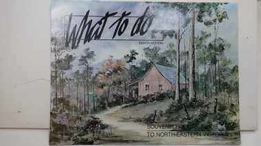 Kiewa Valley Historical Society
Brochure - Tourism, What to do - Souvenir Holiday Guide to North-Eastern Victoria
The Kiewa Valley has promoted itself as a tourist hot spot since the Kiewa Hydro Electric Scheme concluded. Mt Beauty began as a construction town and was to be sold off but tourism became promising so the SECV handed the town over to the Bright Shire, houses were sold and businesses commenced. From the early 1960s the town promoted itself and Falls Creek as a tourist destination. The Kiewa Valley Accommodation group combined with the local advertisers to publish this brochure.This brochure promotes tourism all year round promoting the local businesses enabling them to succeed. As tourism is the main industry in Mt Beauty and Falls Creek since the Kiewa Hydro Electric Scheme finished, this advertising is important. It is interesting to note the businesses - their type, their location and the comparison with those in the area now.19 black and white pages including maps and advertisements. Cover is a 'washed' color of a hut in the bush. The title is in black across the top and at the bottom right hand corner. The front cover is in 'landscape' format but the rest of the book is 'portrait'.mt beauty; falls creek; kiewa valley; tourism; north east victoria -
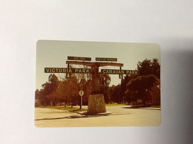 Port of Echuca
Colour Photograph, Approx.1979
In 1869 the Council moved to name this park "Victoria Park. The cricket pitch construction began in 1873 and major improvements to the ground were undertaken in 1881. It is still the primary sporting ground in Echuca, offering AFL football oval, cricket pitch and nets, athletics and entry to the Echuca boat ramp and the natural bush land of the scenic drive. It also houses Echuca Council caravan park. The signage in this photograph is no longer there and the enterance to the caravan park has moved.This area of Echuca has historically been a major recreational area for the town. Being the primary sporting ground since its establishment in 1869., the area has a number of sporting and recreational facilities for the people of Campaspe Shire, from natural bush walks in and along the Murray river to more formal facilities such as AFL football ground, firefighting training area, netball courts, cricket pitch and nets, and grass tennis courts. Colour photograph (post-card size) of directory signs to entrance of Victoria Park, Echuca taken facing north. Two driveways are shown, to the east "Caravan Park" and to the west , "Victoria Park", "Boat ramp", " Scenic drive"Printed in black on the reverse:"this paper manufactured by Kodak"echuca, port of, echuca council caravan park, victoria park, echuca, echuca-tourist attraction -
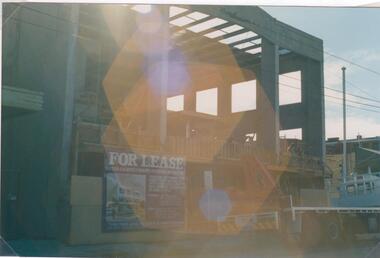 Glen Eira Historical Society
Photograph - Hawthorn Road, 342, Caulfield
Two items about this address: 1/Two colour photos of a commercial building under construction on Hawthorn Road in September 1987. Building is south of Glenhuntly Road on western side And was being built for Caulfield City Council. 2/Print of comment entered 03/03/2019 on Victorian Collections website for this file from reader Angus giving street number as '342'. Google map photo print done 04/04/2019 confirms this.hawthorn road, caulfield, caulfield city council, commercial buildings, council buildings -
 Eltham District Historical Society Inc
Photograph, Kerb and channeling works, Beard Street and Main Road, Eltham, 3 Sep 1981
Roll of film taken by Eltham Shire Council officers of roads and houses in the Eltham East area, 3 September 1981 prior to construction of new water main; including views of existing damage to footpaths and gutters and general views of Beard Street. These images provide a perspective of housing estate developments and changes in housing styles and road development which began sweeping in from the mid 1970s with increasing urbanisation of what was once more outlying suburbs and regions.35mm colour positive transparency (1 of 28) Mount - Kodak Kodachrome Cardbeard street, eltham, footpaths and gutters, infrastructure, roads, main road -
 Eltham District Historical Society Inc
Photograph, Beard Street, Eltham, 3 Sep 1981
Roll of film taken by Eltham Shire Council officers of roads and houses in the Eltham East area, 3 September 1981 prior to construction of new water main; including views of existing damage to footpaths and gutters and general views of Beard Street. These images provide a perspective of housing estate developments and changes in housing styles and road development which began sweeping in from the mid 1970s with increasing urbanisation of what was once more outlying suburbs and regions.35mm colour positive transparency (1 of 28) Mount - Kodak Kodachrome Cardbeard street, eltham, infrastructure, roads, horse, park road -
 Eltham District Historical Society Inc
Photograph, Foothpath and kerb damage, Bainbridge Drive, Eltham, 3 Sep 1981
Roll of film taken by Eltham Shire Council officers of roads and houses in the Eltham East area, 3 September 1981 prior to construction of new water main; including views of existing damage to footpaths and gutters and general views of Beard Street. These images provide a perspective of housing estate developments and changes in housing styles and road development which began sweeping in from the mid 1970s with increasing urbanisation of what was once more outlying suburbs and regions.35mm colour positive transparency (1 of 28) Mount - Kodak Kodachrome Cardeltham, infrastructure, roads, bainbridge drive, footpaths and gutters -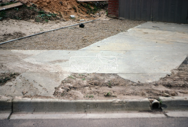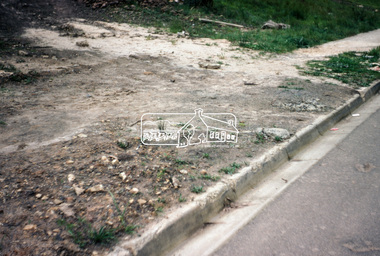
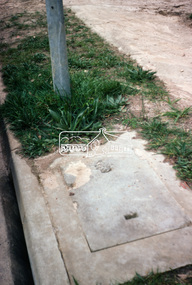 Eltham District Historical Society Inc
Photograph, Foothpath and kerb damage, Bainbridge Drive, Eltham, 3 Sep 1981
Roll of film taken by Eltham Shire Council officers of roads and houses in the Eltham East area, 3 September 1981 prior to construction of new water main; including views of existing damage to footpaths and gutters and general views of Beard Street. These images provide a perspective of housing estate developments and changes in housing styles and road development which began sweeping in from the mid 1970s with increasing urbanisation of what was once more outlying suburbs and regions.35mm colour positive transparency (1 of 28) Mount - Kodak Kodachrome Cardeltham, infrastructure, roads, bainbridge drive, footpaths and gutters