Showing 10876 items
matching land
-
 Eltham District Historical Society Inc
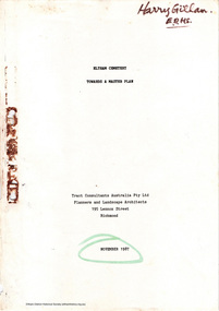
Document - Report, Tract Consultants Australia Pty Ltd, Eltham Cemetery: Towards a Master Plan, Nov 1987
BACKGROUND The Eltham Cemetery is of historic significance to the Eltham area. The Trust was established in 1858 and has administered and maintained the cemetery from that date right up to the present. Among the more noteworthy graves is that of Sir William Irvine, a former State Premier and Chief Justice of Victoria. Eltham Cemetery is surrounded on three sides by urban development. Montsalvat Artists Colony adjoins the remaining (eastern) side. A Joint Select Committee of Parliament called the “Mortuary Industry and Cemeteries Administration Committee" (MICA) enquired into the land requirements at the Eltham Cemetery in 1986. The MICA recommendations contained in its 1986 report are included in the Appendices attached to this report. Although the recommendations have not been adopted by the Government it is interesting to note that the MICA report recommended the use of the bulk of the land for cemetery purpose. In June of 1987, the Cemetery Trust was expanded to include additional members from the Eltham Community by the Minister for Health. At the same time, he instructed the Trust to resolve the land requirement issues. As a result of this Ministerial direction, Tract Consultants has been instructed by the Eltham Cemetery Trust to prepare a report addressing the issues raised in the Minister's letter (see Appendix 1) to the Trust. Principally, the study will examine options available for development of the Cemetery. These options will explore possible boundaries, cemetery design, vegetation, the overall environment, landscaping and financial planning for the Cemetery operations. Appendix 2 details the Cemetery Trusts Terms of Reference for the Study. Before commencing the study in detail, additional basic information was sought; viz: a) sub-soil and rock analysis; and b) feature survey by a Licensed Surveyor. The results from both exercises are included as appendices to this report. Section three includes a summary of the findings along with other analytical results. Also: Eltham Cemetery - planning bewteen 1859 to 1860; research by Alan Sheehan April 2015, collated by Harry Gilham, EDHS, April 2016 (2 pages) PROV Guide 5: Cemetery Records (8 pages), printed 7 May 2014Development of Eltham Cemeteryeltham cemetery trust, master plan, mica, montsalvat, mortuary industry and cemeteries administration committee, tract consultants -
 Orbost & District Historical Society
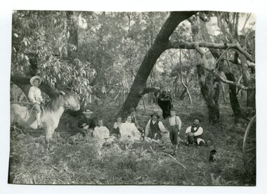
black and white photograph, 1901
This photograph was taken at the "old station" at Corringle near Orbost. It was a popular picnic spot. Late in 1857 Mr Thomas T. Stirling took over Corringle Run ("Corringle" means "shallow water"). Mr Stirling and his family came from the wester district - Winchelsea. He settled at the Old Station. A few people were employed at the Orbost Stationb and there was settlement on the Orbost flats, Mr T. T. Stirling held the land from Lake Tyrers to Bemm River as a cattle run. About 1888 he became Secretary of the new Tambo Shire.This is a contemporary pictorial record of rural family life in Orbost in the early 20th century.A black / white photograph of a group of people sitting in a clearing under some trees having a picnic. On the left - hand side is a young boy on a horse.on back - "Old Station"old-station-orbost family-life -
 Orbost & District Historical Society
black and white photograph, 1901
The Old Station at Corringle was a popular picnic spot in 1901. Late in 1857 Mr Thomas T. Stirling took over Corringle Run ("Corringle" means "shallow water"). Mr Stirling and his family came from the wester district - Winchelsea. He settled at the Old Station. A few people were employed at the Orbost Stationb and there was settlement on the Orbost flats, Mr T. T. Stirling held the land from Lake Tyrers to Bemm River as a cattle run. About 1888 he became Secretary of the new Tambo Shire.This is a contemporary pictorial record of rural family life in Orbost in the early 20th century.A black / white photograph of a group of early settlers (it appears to be a family group) having a picnic underneath trees. There is a young boy on a horse on the left hand side.on back - "Picnic at the Old Station"family-rural-life-orbost old-station-corringle -
 Warrnambool and District Historical Society Inc.
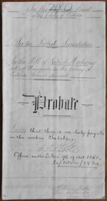
Document - Patrick Mahony Probate 1894, 1894
These are the Probate papers for Patrick Mahony, a farmer from Wangoom who died in 1894. He left an estate of £995 and personal effects worth £138. The estate was to be administered by the two sons, William and Timothy in trust for another son, Michael Mahony. The wife Margaret was granted three acres of land, £25 a year and ‘the choice of two cows out of my stock’. The daughter Johanna was to receive the same benefits after the death of her mother. Patrick Mahony, being illiterate, signed his will with a cross. Tait collection: item 12 of 62This document is of interest as it concerns a local farmer, Patrick Mahony and a local lawyer, William Ardlie. The latter had a practice in Warrnambool for the best part of seventy years, firstly in Timor Street and then in Kepler Street. He was a prominent resident in Warrnambool. The document was originally in the hands of the law clerk, Thomas Goodall and it was passed on to lawyers occupying the Kepler Street premises until it was found in the buildings once used by the law firm of Mackay Taylor. This is a piece of parchment paper, folded in two with writing in black ink on all four pages. There is a seal of the Supreme Court of the Colony of Victoria attached with a green ribbon and three red stamps of the Master in Equity in the Supreme Court. The document has ruled lines and some annotations in the margins. ‘280, In the Supreme Court of the Colony of Victoria, in the Probate Jurisdiction in the Will of Patrick Mahony, late of Wangoom, in the Colony of Victoria, Farmer deceased, Probate. I certify that there is no duty payable on the within Probate, J. Poole, Officer under Section 96 of Act 1060, 24/October/1894, William Ardlie, Proctor for Executors, Warrnambool’patrick mahony, william ardlie, warrnambool -
 Warrnambool and District Historical Society Inc.
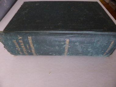
Book, The library dictionary of the Eng language
This dictionary belonged to John Brass, an early settler in South Warrnambool. He owned several block of land and operated a lighterage business with John Young. As a lighterman and boatman he was well-known in Warrnambool. He was drowned in March 1895 while attempting to cross a temporary foot bridge across the Merri River. His house (probably in Stanley Street) was built in 1868 and remained as an interesting example of a lighterman’s cottage until1974. The dictionary probably became the property of W. Macdonald after John Brass’ death. No information has been found on this W. Macdonald. This book is of interest as it belonged to John Brass, an important early settler in South Warrnambool. This is a hard cover book of 974 pages. The cover is green with embossed patterning and lettering on the front cover and gold lettering on the spine. The book has a Preface, a Contents page, the Dictionary entries and an Appendix. There are many illustrations, from engravings on wood, scattered throughout the text. The cloth binding is coming loose and there are several loose pages. The last page is missing. The inscriptions are written in pencil and in blue ink and there are red stamps of John Brass. The cover is stained and faded. ‘John Brass, South Warrnambool, Victoria, Aust- 1893’ ‘June 5 x 6 x 93’ ‘J.Brass, Jetty’ Stamps – ‘John Brass, South Warrnambool’ ‘W.J. Macdonald, Moyston, Dec.23-11-95’ ‘W.J.McDonald’ john brass, history of south warrnambool, w. macdonald (moyston), warrnambool’s maritime history -
 Warrnambool and District Historical Society Inc.
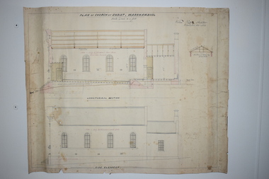
Document, Plan of Church of Christ Warrnambool, 1883
These plans have been drawn up in 1883 by the Warrnambool architect, William Patterson. They show six sections of plans for the erection of a Church of Christ at 12 Spence Street Warrnambool. The mason was William Kellas and the builder was Harold Dawkins. Church of Christ adherents began meeting in Warrnambool in 1875 and bought land in Spence Street in 1877. The church was opened in 1885 with visiting pastors until a resident minister, A. J. Fisher, was appointed in 1915. This church was closed early in the 21st century when a new church, Gateway Church of Christ, was opened in Ragland Parade in Warrnambool. These plans are of great interest as original ones of the Church of Christ In Spence Street Warrnambool. The plans have come from the present-day Warrnambool Church of Christ. The building still exists but is no longer is use as a church. These are two sheets of cream-coloured thick paper with scaled drawings of plan sections of the Church of Christ in Warrnambool. The drawings are in black ink with some sections coloured in. Both pages have a black line margin drawn around the edges. The pages are torn at the edges in several places and the sheets are much stained. The sheets have been reinforced at the back (left side) with thick brown paper.‘Plan of Christ Church Warrnambool’plans church of christ warrnambool, william kellas, harold dawkins warrnambool -
 Warrnambool and District Historical Society Inc.
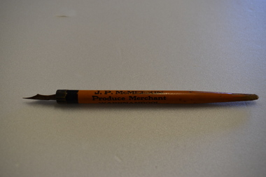
Pen and Nib, Early 1930s
This item has come from the business of J.P.McMeekin of Warrnambool. It would have been sold or given to clients of the business for promotion purposes. The father of James McMeekin, with his brother, William, established their business in Warrnambool in the early 1880s with land, estate and insurance agencies and a produce store, including a dairy produce trade exporting butter to South Australia, South Africa and England. The business was initially in Fairy Street Warrnambool and then moved to Kepler Street. James McMeekin’s son, also James Parker McMeekin (1885-1935) continued on with the business until his death.His pen is of interest as an example of the type of promotion item issued by business men in Warrnambool in the 1930s. This is a pen with a brown-coloured wooden body tapering to a point at its end. It has a metal band at the other end with a metal nib inserted. The end of the pen is slightly broken and the nib is rusted. J.P.McMeekin Produce Merchant Warrnambool Phone 263j.p.mcmeekin, history of warrnambool -
 Eltham District Historical Society Inc
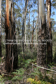
Photograph - Digital Photograph, Alan King, Manna Gums at the Gawa Wurundjeri Aboriginal Resource Trail, 28 December 2007
Manna Gum is a species of a small to a very tall tree that is endemic to south-eastern Australia. These particular trees are part of the Gawa Wurundjeri Resource Trail at Watsons Creek. Signs share information about how the Wurundjeri people lived near the creek and used the land to obtain bush foods, medicines, tools, shelter and clothes. The trail introduces visitors to the indigenous flora and fauna, including manna gums, Lomandra (used to weave baskets) and wombat burrows. Published: Nillumbik Now and Then / Marguerite Marshall 2008; photographs Alan King with Marguerite Marshall.; p3This collection of almost 130 photos about places and people within the Shire of Nillumbik, an urban and rural municipality in Melbourne's north, contributes to an understanding of the history of the Shire. Published in 2008 immediately prior to the Black Saturday bushfires of February 7, 2009, it documents sites that were impacted, and in some cases destroyed by the fires. It includes photographs taken especially for the publication, creating a unique time capsule representing the Shire in the early 21st century. It remains the most recent comprehenesive publication devoted to the Shire's history connecting local residents to the past. nillumbik now and then (marshall-king) collection, gawa wurundjeri aboriginal resource trail, manna gums, watsons creek -
 Glen Eira Historical Society
Article - Shoobra Road, 52, Elsternwick, 'Wee Nestie'
Four items about this property: One typed document and its handwritten document of working notes on 52 Shoobra Road. Document gives a brief history of land subdivision and local tenants and owners of number 52 Shoobra Road by Brighton Historical Society One typed letter to J Atkin form Brighton Historical Society One photocopied typed letter to Rosalind Landells from Jenni Atkin dated 24/05/1993 Domain.com.au advertisement giving details for upcoming auction of the property on 08/09/2013. Includes 4 photographs of property.riddell john carre, pioneers, elsternwick, cavers carre, caulfield, hamilton thomas ferrier jp, land subdivision, hamilton street, shoobra road, wee nestie, ettrick, deeside, cerutty peter, cerutty lem mrs, kirby charles p, kirby charles f, landells rosalind, bullock hilary, atkin jenni mrs, house names, timber houses, edwardian style, noel jones real estate, brukarz jack, real estate agents, ashton daniel, stavrakis bill, lead lights, verandahs -
 Eltham District Historical Society Inc
Newsletter, Eltham District Historical Society, Newsletter, No. 241 August 2018
Contents: • Finding a Home by Russell Yeoman • Our Next Meeting – Wednesday 8th August 2018 • Open Day at our Local History Centre – Saturday 1st September 2018 • Eltham 1950s – Childhood Reminiscences – Part 5 by Ann Constable • Land for Sale at Little Eltham by Russell Yeoman • The County of Evelyn by Russell Yeoman • An ‘enlightening’ tale by Jim Connor • The Andrew Ross Museum by Mick Woiwod • Kangaroo Ground – Centre of the Shire by Mick Woiwod • On the Thirsty Road to the Diggings by Mick Woiwod • Contacts for the Eltham District Historical Society The Shire of Eltham Historical Society was formed in October 1967. The first newsletter of the Society was issued May 1978 and has been published continuously ever since on a bi-monthly basis. With the cessation of the Shire of Eltham in late 1994, the Society's name was revised to Eltham District Historical Society and this name first appeared with issue No. 103, July 1995. The collection of the Society's newsletters provides a valuable resource on the history of the Society's activities, office bearers and committee members, guest speakers and subjects of historical interest pertinent to the former Shire of Eltham and the Eltham District.A4 newsletter distributed to membersnewsletter, eltham district historical society -
 Federation University Historical Collection
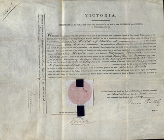
Document, Certificate to Naturalize under the Provisions of an Act of the Governor and Council, Victoria, 13 June 1860
In 1860, Charles Herold of Ballarat, a gold miner applied to be naturalized. He was born in Kitzinger Bavaria and at the age of thirty-five arrived by the ship "Mary Ross" in Tasmania in 1854 from Hamburg. He then came to the Colony of Victoria by the SS "Queen" in 1857. He wished to purchase land and settle in the Colony for life. This was granted but he first needed to swear an Oath before one of the Judges of the Supreme Court. The Certificate was signed by Henry Barkly. Charles Herold took the Oath before Robert Molesworth, Judge of the Supreme Court on 18 July 1860.Thick cream paper, hand written in ink. Official seal - red and gold - between two pieces of light blue paper and dark blue ribbonSeal Signature of I Moore Date 13 June 1860 Signature of Governor of Victoria, Sir Henry Barklyballarat, naturalize, colony of victoria, judge of the supreme court, charles herold, kitzinger, bavaria, gold miner, henry barkly, robert molesworth -
 Wycheproof & District Historical Society Inc.
Photograph - Coloured photograph, framed, 1940
Michael Forrester b.1866 Branxholme,Victoria,d.1945 age 79 years. Buried Quambatook,he was the 8th of 10 children of parents, Pat and Johanna Forrester, both buried at Wycheproof. A bachelor farmer, Michael worked on the selection property at East Towaninnie.He and his unmarried sister, Ellen Forrester, inherited some of the parents' land, sold it and lived out their final years at Quambatook. Typical of many early local residents,Michael was born into a large family and did not move far from his beginnings. Farming and family was his life. This photograph is of Michael Forrester a local member of the community who spent most of his adult life in the area.Large glass framed 'Heirloom' photo reproduced from a 1940 photo- ornate and oval framed.Coloured formal photo with bronze attachment with words, "portrayed by the artist in a manner and quality befitting work to be passed on to future genertions as a priceless heirloom.Workmanship and materials guaranteed." Heirloom Product Style 37. F.L. Wirth Art Director. Price 5 Guineas.michael forester, branxholme -
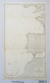 Flagstaff Hill Maritime Museum and Village
Document - Navigation Chart, Portsmouth to Canary Islands, Ca. 1928
This is an Official British Admiralty Navigation Chart, one of a set of 65 charts donated together with a wooden chart case. It was published and printed in London in 1928 by the British Admiralty. Navigation charts are drawn by professional hydrographers and describe the geography of land and water, enabling a water based navigator on board vessels such as ships to safely negotiate between ports locally and around the world. They are drawn to a particular standard with common symbols noting landmarks. The charts are used in conjunction with other navigational instruments and tools to calculate the vessel’s exact location and a safe route to its destination.The set of charts and their chart are of significance as examples of equipment and documents used to navigate the oceans of the world, particularly to Australia. Migration to Australia is an important part of this country's history.British Admiralty Navigation Chart - Portsmouth to Canary Islands - printed on rectangular white paper. Published in London by the British Admiralty in 1928.warrnambool, shipwreck coast, flagstaff hill, flagstaff hill maritime museum, flagstaff hill maritime village, chart, map, navigate, navigation, location, vessel, 1928, british admiralty, hydrographer, geography, admiralty chart, portsmouth, canary islands -
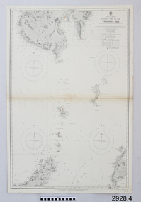 Flagstaff Hill Maritime Museum and Village
Document - Navigation Chart, Eastern Part of the Celebes Sea, Ca. 1928
This is an Official British Admiralty Navigation Chart, one of a set of 65 charts donated together with a wooden chart case. It was published and printed in London in 1928 by the British Admiralty. Navigation charts are drawn by professional hydrographers and describe the geography of land and water, enabling a water based navigator on board vessels such as ships to safely negotiate between ports locally and around the world. They are drawn to a particular standard with common symbols noting landmarks. The charts are used in conjunction with other navigational instruments and tools to calculate the vessel’s exact location and a safe route to its destination.The set of charts and their chart are of significance as examples of equipment and documents used to navigate the oceans of the world, particularly to Australia. Migration to Australia is an important part of this country's history.British Admiralty Navigation Chart - Eastern Part of the Celebes Sea - printed on rectangular white paper. Published in London by the British Admiralty in 1928.warrnambool, shipwreck coast, flagstaff hill, flagstaff hill maritime museum, flagstaff hill maritime village, chart, map, navigate, navigation, location, vessel, 1928, british admiralty, hydrographer, geography, admiralty chart, celebes sea -
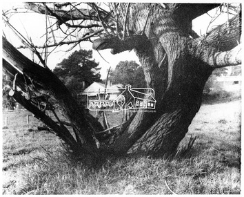 Eltham District Historical Society Inc
Negative - Photograph, George W. Bell, Gahan house, Main Road, Eltham, c.1964
View of Gahan house originally known as 'Derril' framed by an old tree. Part of a collection of photos donated by George W. Bell to the former Shire of Eltham, c.1970. In 1964 the Shire of Eltham acquired the land upon which Shillinglaw Cottage stood for the purposes of building a new Shire Office. Shillinglaw Cottage was to be demolished but a campaign was managed by the local community to save Shillinglaw Cottage which was relocated to its present day site, (Panther Place, Eltham) immediately in front of the Gahan house as viewed in the photo. The Gahan house was subsequently demolished.This photo forms part of a collection of photographs gathered by the Shire of Eltham for their centenary project book, "Pioneers and Painters: 100 years of the Shire of Eltham" by Alan Marshall (1971). The collection of over 500 images is held in partnership between Eltham District Historical Society and Yarra Plenty Regional Library (Eltham Library) and is now formally known as 'The Shire of Eltham Pioneers Photograph Collection.' It is significant in being the first community sourced collection representing the places and people of the Shire's first one hundred years.Digital image 4 x 5 inch B&W Negsepp, shire of eltham pioneers photograph collection, eltham, shillinglaw cottage, gahan, gahan house, george w. bell collection, houses, main road, panther place, significant tree -
 Warrnambool and District Historical Society Inc.
Book, Book Holy Bible, 19th century
This Bible was owned by Janet Hose (nee Murfitt) 1856-1947. She was married to George Hose and they lived in Warrnambool for all of their married life. They had eleven children and all the births and some of the deaths of the children are recorded in this little Bible. The book was purchased from James Hider who had been a carpenter, a land agent and a rate collector before he established a bookstore in Timor Street in the 1860s. He was heavily involved in community affairs, being a local Councillor and Mayor in 1868-9. He was also an early commercial photographer in Warrnambool. This small Bible is of great interest because of its connection to the Hose family in Warrnambool. In the book are recorded the births and deaths of members of the Hose family. It was a common custom in the 19th century to include family history details in family Bibles and some larger-style Bibles had pages specifically printed to include family history material. This Bible is also of antiquarian interest, an attractive item with its leather cover and gold clasp.This is a mottled brown leather-covered Bible of 840 pages. The pages are gilt-edged and there is a gold metal clasp to close over the pages. Inside the front and back pages there are signatures and other handwritten material, some written in black ink and some in pencil. There is also a label from the Warrnambool book shop and stationery store of James Hider. The inscription pages and the front cover are stained. The cover is also rubbed. ‘J.Hider Opposite the Post Office Warrnambool’ ‘Janet Hose 19/07, 78,83 (Plus the family history details of the Hose Family, mostly on the back pages) janet and george hose, history of warrnambool -
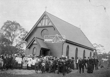 Eltham District Historical Society Inc
Negative - Photograph, St Mary's Catholic Church, cnr Main Road and Henry Street, Eltham, c.1912
St Mary's Catholic Church, cnr Main Road and Henry Street, Eltham was opened/blessed October 13, 1912. The wooden church was built to replace an earlier brick church also known as St Mary's (1865-1912), which had been situated on the main road near present day Wingrove Park. The church and land cost £1,400 (Evelyn Observer). The wooden church was destroyed by fire in 1961. Record includes a photo print copy of image as illustrated in the 'Diamond Valley News', 4 Feb 1998, p 31.This photo forms part of a collection of photographs gathered by the Shire of Eltham for their centenary project book,"Pioneers and Painters: 100 years of the Shire of Eltham" by Alan Marshall (1971). The collection of over 500 images is held in partnership between Eltham District Historical Society and Yarra Plenty Regional Library (Eltham Library) and is now formally known as the 'The Shire of Eltham Pioneers Photograph Collection.' It is significant in being the first community sourced collection representing the places and people of the Shire's first one hundred years.Digital image 4 x 5 inch B&W Negsepp, shire of eltham pioneers photograph collection, eltham, church, catholic church, henry street, main road, st marys catholic church -
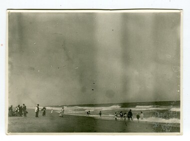 Orbost & District Historical Society
black and white photograph, January 1901
This photograph was taken at the "old station" at Corringle near Orbost. It was a popular picnic spot. Late in 1857 Mr Thomas T. Stirling took over Corringle Run ("Corringle" means "shallow water"). Mr Stirling and his family came from the wester district - Winchelsea. He settled at the Old Station. A few people were employed at the Orbost Stationb and there was settlement on the Orbost flats, Mr T. T. Stirling held the land from Lake Tyrers to Bemm River as a cattle run. About 1888 he became Secretary of the new Tambo Shire.This is a contemporary pictorial record of rural family life in Orbost in the early 20th century.A black / white photograph showing people on a beach with some in the water. those on the sand are dressed formally - men wearing suits and hats, the ladies in long dresses and hats.on back - "Picnic at OLD STATION Jan 1901"orbost-station orbost-family-life recreation -
 Orbost & District Historical Society
black and white photograph/ poscards, Vogt. W.S, C1890 - 1920
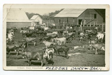
Edward James Pardew died in 26/9/1927 aged 92. He came to Orbost from New Zealand in 1886 and selected 720 acres of hill land in the Brodribb area. He was a member of the first Orbost Shire Council. His daughter had a fruit & meat shop in McLeod Street. He was an inaugural vestryman of St James Church of England. One of the most prominent farmers on the Snowy was John Gilbert, a large landowner. His breeding establishment was at Tullagoota, about two and a half kilometres down the river from Orbost.Dairying in the Orbost district was once a mainstay of the farming community. Today the properties are fewer and smaller.Two black / white photographs of dairy herds. 3188.1 - on front - printed -"ORBOST EAST GIPPSLAND"; hand-written - :PARDEWS DAIRY & BARN" 3188.2 - on front - printed - " W. S. VOGT"; hand-written - "DAIRY HERD TALLAGOOTA< ORBOST"dairying-orbost agriculture-orbost pardew-dairy tallagoota-dairy -
 Orbost & District Historical Society
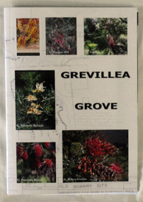
Book, Grevillea Grove, 2017
This book was compiled and published in 2017. The contents are based on a scrapbook and photographs compiled by Margaret Kleinitz who was Secretary of the Orbost Garden Club during the time when Grevillea Grove was proposed and developed from1979-1989. The development of this garden in a disused quarry in Orbost involved a substantial community campaign and on-going effort, particularly from members of the Garden Club. The demise of Grevillea Grove came when the Vic. Govt. decided to develop this parcel of crown land for a Rainforest Garden and Information Centre. Local resident, Audrey Van Den Berg has compiled this book. Shows the effort and dedication involved in this community project.A 40 page book with cardboard cover. Front cover has 6 colour photos of Grevillea plants overlaid onto a plan of the Grevillea Grove garden. This book contains b/w photographs and a written history of the creation of the Grevillea Grove garden in Orbost. It also has site plans and newspaper articles.GREVILLEA GROVE grevillea grove, orbost -
 Orbost & District Historical Society
smoking cap, late 19th century
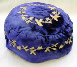
Smoking Caps are caps worn by men while smoking to stop the hair from smelling of smoke. They also kept the head warm. They were popular in the period 1840-1880, usually worn by gentlemen in the privacy of their home. This beautiful velvet smoking cap was worn by James Stirling who was the first settler to occupy land in the Marlo township. James stirling arrived in Victoria from Scotland in 1842.He took over Corringle Station (Ewing's Marsh). His son James stirling later established theMarlo Hotel. (Read more in Mary Gilbert’s book)Smoking accessories like this cap were popular through the mid-to-late nineteenth century to prevent the smoker's hair from absorbing the smell of tobacco smoke and were often worn with smoking jackets. The design, with its elaborate embroidery shows an aspect of Victorian material culture and reflects the nineteenth-century love of 'Oriental' style. . A domed shaped smoking cap of blue velvet .It is lined with silk. The tops and sides are embroidered with tan coloured leaves. head-coverings stirling-james smoking-cap -
 Marysville & District Historical Society
Photograph (Item) - Colour photograph, Unknown
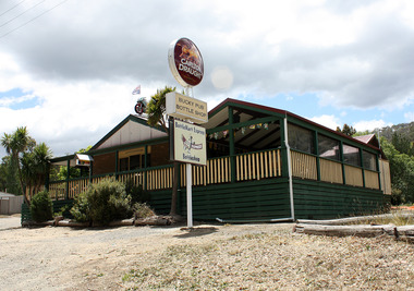
A colour photograph of the Buxton Hotel in Buxton. The Buxton Hotel was built by William Burchall, probably in the late 1870s. The first owner, who also had land locally, was Frederick Nichols (1833-1904). The Buxton Hotel is located directly opposite the General Store. It was fronted with two huge oak trees and bordered and backed by large pine trees. It was a weatherboard structure with a painted corrugated iron roof. Old split wood shingles were covered by corrugated iron, which overlaid the shingles to make the roof watertight. The wooden shingles date back to the 1850s.A colour photograph of the Buxton Hotel in Buxton.buxton, victoria, australia, buxton hotel, william burchall, frederick nichols, accommodation, carlton draught, photograph -
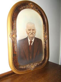
 Federation University Historical Collection
Photograph, Geoff Biddington, Former Cyril Retallick House (Now Australian Catholic University), Ballarat, c1967
In 1881 Cyrus Bath Retallack purchased land now known as 1200 Mair Street Ballarat. Retallack was a successful Cornish miner and engineer. He built a two storey brick mansion between 1882 and 1883, naming the property ‘Carn Brae’ after the castle in Cornwall. Substantial grounds were established with with range of exotic trees planted, a tennis court was laid out and a stables building was erected. In 1918 the site become a campus of Queen’s GIrls’ Grammar School, then Aquinas College which was merged into the Australian Catholic University from 1973. Photograph of a double storey brick building on bluestone foundations, with cast iron balcony. ballarat, geoff biddington, cast iron, bluestone, cyril retallick, australian catholic university, ballarat, aquinas college -
 Federation University Historical Collection
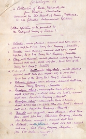
Document, SMB: Catalogue of a Collection of Rocks, Minerals, etc, 1883
This list of rocks, minerals, etc. from Victoria was complied and forwarded by the School of Mines, Ballarat, to the Calcutta International Exhibition. At the end of the exhibition the items were to be presented to the Geological Survey of India. One Hundred items are listed. Pages 4 and 5 also show diagrams relating to the land formations and sections. Places in Victoria are named indicating where items were found. List compiled by Professor Ferdinand Moritz Krause. He joined Ballarat School of Mines in 1880 and lectured in Mineralogy and Geology. He was also the Curator of the Ballarat School of Mines Museum.6 pages, handwrittenSignature of F M Krause Dated 30th August 1883ballarat school of mines, rocks, minerals, calcutta international exhibition, geology survey of india, victoria, professor ferdinand moritz krause, mineralogy, geology, curator, ballarat school of mines museum -
 Bendigo Historical Society Inc.
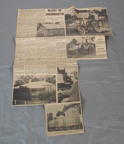
Newspaper - Lydia Chancellor collection: McKay of Drummartin
William McKay came to Australia in 1851 with three sons and four daughters. He selected land at Drummartin and the family farmed extensively. Williams grandson, Hugh Victor, was only sixteen and helping his father with the wheat harvest, when he had the idea to make a machine that would both strip and winnow the wheat, thus saving time and effort. His first machine was ready by February 1884. Hugh Victor subsequently started a small factory in Ballarat before moving to the Melbourne suburb of Sunshine. Thus became what is known as the Sunshine combine harvester.Bendigo Advertiser from Saturday May 9, 1970. The article is titled: "McKay of Drummartin, he began a new era for the world". Several photographs complement the article.drummartin, mckay -
 Donald History and Natural History Group operating the Donald Court House Museum
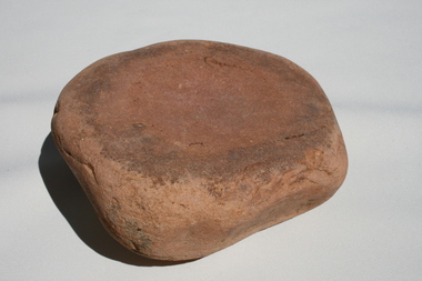
Aboriginal grinding stone (mortar)
This grinding stone (mortar) was used by Aboriginal people to grind or crush different materials such as berries and seeds for food production. In order to grind material, a smaller upper stone (the pestle) would have been used to grind material against this lower stone (the mortar). The stone was found by a farmer on land south of Donald in the 1950’s and was used as a door stop in the family home for many years. In the 1990's the stone was used by the farmer's grandaughter at her home at Swanwater West, to hold the lid down on an above ground swimming pool skimmer box. Stone -
 City of Ballarat
Artwork, other - Public Artwork, Marley Smith et al, Campsite by Marley Smith and Billy Blackall, 2020
The Campsite mural features Bunjil (wedge-tailed eagle) the creator and spiritual leader for Aboriginal people of this land. The Baarlijan (platypus) is a representation of the local Aboriginal community who have come from different Aboriginal nations and have made Ballaarat their home. The circular motifs represent campsites of different sizes located across Ballaarat, indicating that Ballaarat was and continues to be an important meeting place. Campsite (2020) is a re-commissioned artwork based on the original Campsite Mural installed in Alfred Deakin Place for the Commonwealth Games in 2006. The Campsite mural features Bunjil (wedge-tailed eagle) the creator and spiritual leader for Aboriginal people of this land. The Baarlijan (platypus) is a representation of the local Aboriginal community who have come from different Aboriginal nations and have made Ballaarat their home. The circular motifs represent campsites of different sizes located across Ballaarat, indicating that Ballaarat was and continues to be an important meeting place. Commissioned by the City of Ballarat. Painted mural on six weatherproof sheetsbunjil, baarlijan, aboriginal history, ballarat history, wadawurrung -
 Stawell Historical Society Inc
Photograph, "Ashen" Homestead Remnants in Murtoa after a Storm c1920’s
Dugald McPherson's Ashen's Homestead (Remnants) c1920’s Ashen's south of Murtoa was one of the area's original squatting runs. This photo taken in the 1920's shows the homestead after a violent storm had been through the area. In 1853, the country around Ashen's was covered by timber, she-oaks, bull-oaks, light gum and box thickets of ti-tree and clumps of pine and wattles. The vegetation was so thick outside the horse paddock it was difficult to move in any direction. It was said McPherson and two others fought over the land.Back entrance to Ashen's Station.stawell -
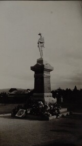 Stawell Historical Society Inc
Photograph, Soldiers’ Memorial World War 1 in Main Street -- Different angle
Soldiers’ Memorial World War 1 with wreaths at base. The "Girl's Remembrance League" worked to raise money for the memorial to be built. Cost was 643.0.0 pounds. The memorial was unveiled on Saturday 10th Nov. 1923, by Archdeacon T.P. Bennett, (a respected pardre and old Stawell boy). Photo was copied from original donated by Mrs. L Matthew's whose mother Mrs. A. V. Cornish was a member of the Girls Remembrance League. Memorial was partly built by Robson & Grey, when partnership dissolved Mr. G.M. Robson completed the work. The Borough Council donated the land for the memorial.Black & white photograph of a World War 1. memorial. The fallen soldier statue is on a tiered granite base with flowers and wreaths around the base and steps of the memorial. There are two black & white photos one an enlargement. stawell ww1 -
 Ballarat Heritage Services
Photograph - Photograph - Colour, Smeaton Presbyterian Church, 2015, 18/12/2015
The Smeaton Presbyterian Church was built in 1859 of locally made brick, and opened in 1860. The building committee was . Messrs. John Hepburn, W. McAlpine, W. Anderson, S. Moore, W. H. Clarke and W. Miller. It cost an estimated 1,200 pounds, and was assisted by Captain John Hepburn who donated 5 acres of land and 150 pounds for the church. The rest was contributed by the settlers and their employees. Around 1890, the outside brickwork was given a coat of cement, which has improved with age. In 1938 the grey stained exterior was described as “not altogether displeasing”. Colour photographs of Smeaton Presbyterian Church.smeaton, smeaton presbyterian church, churches, kooroocheang