Showing 6392 items matching " red white "
-
 Woodend RSL
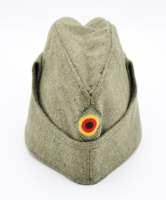
Headwear - Hat (foreign), 1966
Military cap dating from 1966, possibly worn by military personnel in West Germany.This cap is significant as an example of military headwear dating to 1960’s West Germany. Olive drab coloured forage or side cap lined with matching colored fabric. Cap has a flap on each side which may be unfolded. Side flaps are joined by by strip of fabric (all one piece), across the front of the cap which when extended, may form a covering for the mouth area. Flap may be secured with a silver stud button attached to each side of cap. Front of cap displays West German roundel in black, red, and yellow set in olive coloured diamond shaped piece of fabric. Off-white manufacturer’s label on inside, sewn to lining with white thread. Cap is size 54. On inside of hat: (in red) BAMBERGER MUTZEN INDUSTRIE (in black) US12d/22/15565/0028 IX/1966 /5 54 8405-12-138-8897 -
 Disability Sport & Recreation Victoria
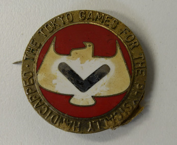
Metal badge, Metal badge from 1964 Tokyo Paralympics, unknown
The 1964 Summer Paralympics, originally known as the 13th International Stoke Mandeville Games and also known as Paralympic Tokyo 1964, were the second Paralympic Games to be held. They were held in Tokyo, Japan, and were the last Summer Paralympics to take place in the same city as the Summer Olympics until the 1988 Summer Paralympics. The 1964 Games, although still formally an edition of the International Stoke Mandeville Games, were the first to use the term "Paralympic" in association with the event; the term "Paralympic Games" was approved by the International Olympic Committee (IOC) first in 1984, while the International Paralympic Committee (IPC) was formed in 1989. In contrast with the 1960 Games, many events had more than three participants, meaning that athletes were no longer guaranteed a medal upon completing their eventMetal and enamel badge.Front: Text: THE TOKYO GAMES FOR THE PHYSICALLY HANDICAPPED Image: White dove with silver chevron across its chest, on a red background. Text in border surrounding the image of the dove. Reverse: Unidentified kanji characters; the katakana for the word "sports"; English text "1964 TOKYO"1964 tokyo paralympics, paralympics -
 Disability Sport & Recreation Victoria
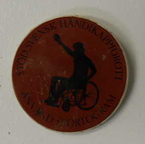
Badge, Swedish disabled sports badge
Round crimson and red plastic badge.Front of the badge has a black silhouette of a wheelchair athlete on a crimson background, surrounded by the Swedish text STÖD SVENSK HANDIKAPPIDROTT - ANVAND SPORTOGRAM (SUPPORT SWEDISH DISABILITY SPORT - USE SPORTOGRAM) Back is plain white, with what is likely to be the badge maker's business name and phone number in red text. "PER EDBERG AB 08-34 04 30" -
 Disability Sport & Recreation Victoria
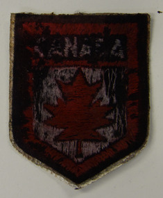
Patch, Canada patch
... The word "CANADA" in white, on a red background. A red... Collingwood The word "CANADA" in white, on a red background. A red ...Shield shaped clothing patch.The word "CANADA" in white, on a red background. A red maple leaf inset a white background. -
 Disability Sport & Recreation Victoria
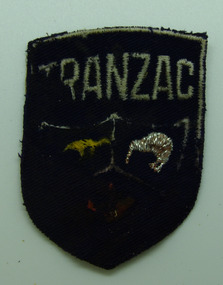
Patch, TRANZAC patch
Shield shaped clothing patch.The word "TRANZAC" in white across the top of the patch, on a navy blue background. Underneath, embroidered images of a kangaroo (in gold), a kiwi (in white), and an indistinct object in red. -
 Disability Sport & Recreation Victoria
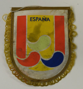
Pennant, Espana pennant
Shield shaped pennant. with thread hanging device.Red/yellow/red striped shield design (imitative of Spanish national flag). on white background. The word "Espana" in dark blue at the top of the yellow band. Underneath, three coloured droplets (green, red, blue), symbolising "body, mind, and spirit", symbolising the Paralympic movement worldwide. The same design is on both sides of the pennant. -
 Disability Sport & Recreation Victoria
Stickers, Stickers and sheets from first Commonwealth Paraplegic Games, Perth 1962, 1962
The 1962 Commonwealth Paraplegic Games, held in Perth, were the first edition of the Commonwealth Paraplegic Games.Approximately 100 stickers, both loose and attached in original sheets.Red image and text, in white/cream background. Drawing of a male wheelchair athlete throwing a javelin, in front of an Australian flag. Text underneath: FIRST COMMONWEALTH PARALYMPIC GAMES. Perth. 10-17 November 1962commonwealth paraplegic games, disabled sports, wheelchair sport, 1962 commonwealth paraplegic games, perth -
 Falls Creek Historical Society
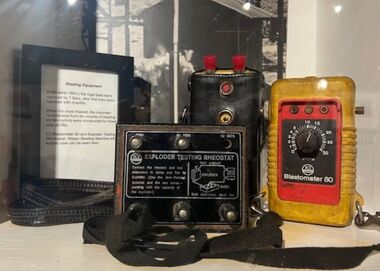
Equipment - Blasting Equipment
In the early 1970s the rope tows at Falls Creek were replaced by T Bars, after which they were replaced by chairlifts. When the snow thawed, the mountains reverberated from the sounds of blasting as new pylons were constructed for these chairlifts.Blasting equipment from the early 1970s in three parts, including a rectangle metal box with black with white text on top and six connectors, a rectangle yellow 'Blostometer 80' and a rectangle box with red knobs at end and enclosed in a black-brown leather case. 'EXPLODER TESTING RHEOSTAT' 'Blastometer 80' 'Nissan Blasting Machine - ICI - 30 shot condenser'falls creek, construction, blasting, explosives, snow, snow fields -
 Falls Creek Historical Society
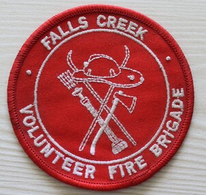
Uniform - Falls Creek Volunteer Fire Brigade
The Falls Creek Volunteer Fire Brigade provided a critical service at Falls Creek. They have since become the Falls Creek CFA with continued support of local Volunteers.This uniform patch represents an important safety organisation at Falls Creek.A red circular cloth badge with writing and fire fighting tools embroidered in white thread.FALLS CREEK VOLUNTEER FIRE BRIGADEfalls creek services, falls creek volunteer fire brigade -
 City of Kingston
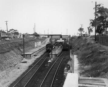
Photograph - Black and white, Public Transport Corporation, c. 1959
Black and white photograph of Moorabbin railway station, at the completion of works to relocate it to below street level. There are two "red rattler" trains pulled in to the station, utilising each of its two tracks and two of its three platforms. A third platform is visible to the left of the image, but no tracks have been laid to allow for an additional train. This image is part of a larger collection of images from the Public Transport Corporation displaying train stations and streetscapes in what is now the City of Kingston.Black and white photograph of Moorabbin railway station, at the completion of works to relocate it to below street level. There are two "red rattler" trains pulled in to the station, utilising each of its two tracks and two of its three platforms. A third platform is visible to the left of the image, but no tracks have been laid to allow for an additional train. Stamped in blue ink on reverse: COPYRIGHT / Public Transport Corporation / For re-ordering photographs / Please quote negative No M6859 / Enquiries C/- PTC Photographic Unit / Telephone switchboard 619 111moorabbin, railway station, red rattler, public transport -
 City of Kingston
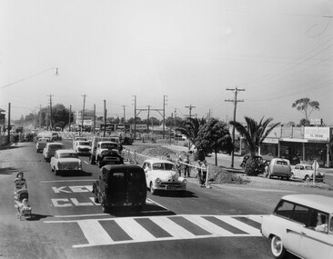
Photograph - Black and white, c. 1957
Copy black and white photograph of railway level crossing on Nepean Highway Moorabbin before excavations for the below ground rail crossing. The level crossing gates are closed and five cars are waiting, while other cars can be seen coming in the opposite direction. A woman with a child in a pram is walking along the road, and a number of men, probably construction workers, are standing behind a barricade on the right hand side of the road. Gilbey's Gin distillery is visible in the background. TCopy black and white photograph of railway level crossing on Nepean Highway Moorabbin before excavations for the below ground rail crossing. The level crossing gates are closed and five cars are waiting, while other cars can be seen coming in the opposite direction. A woman with a child in a pram is walking along the road, and a number of men, probably construction workers, are standing behind a barricade on the right hand side of the road. Gilbey's Gin distillery is visible in the background. Handwritten in blue ink on reverse: 57-465C Handwritten in red ink on reverse: 71% A red circle has been drawn around all handwritten text.moorabbin, railway station, railway crossing, suburbs, cars, local production -
 City of Kingston
Photograph - Black and white, c. 1950
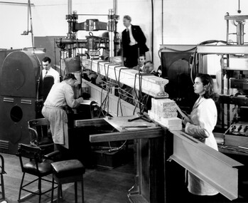
CSIRO, the Commonwealth Scientific and Industrial Research Organisation, moved into a former RAAF factory in Highett in the post-war years. CSIRO closed down the Highett facility and sold it in 2011.Black and white photograph of workers at CSIRO (Commonwealth Scientific and Industrial Research Organisation) complex in Highett. In this image, building materials are being tested. In the foreground is physicist Valerie Goullet, standing top centre is Dr Keith Martin both CSIRO Division of Building Research.Small white sticker adhered to reverse of image with printed black text: 206 Handwritten in red ink on reverse of image: 53%science, highett, workers, industry -
 City of Kingston
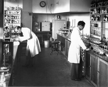
Photograph - Black and white, c. 1950
CSIRO, the Commonwealth Scientific and Industrial Research Organisation, moved into a former RAAF factory in Highett in the post-war years. CSIRO closed down the Highett facility and sold it in 2011.Black and white photograph of workers at the CSIRO (Commonwealth Science and Industrial Research Organisation) facility in Highett.Small white circular sticker with black printed text: 205 Handwritten in red ink: 55%science, highett, workers, industry -
 City of Kingston
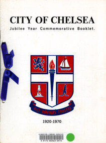
Booklet - Commemorative book, City of Chelsea, City of Chelsea Jubilee Commemorative Booklet, 1970
In 1920 the City of Chelsea was formally proclaimed to be a city, rather than a township. This booklet, produced in 1970 was to commemorate it being 50 years since Chelsea was proclaimed a city.Five (5) page booklet with white cardboard covering with black text at top and bottom and a blue and red coat of arms for the City of Chelsea in the centre. The book was, at one time, registered with the Kingston Library Service and has a barcode and green sticky dot adhered to the front. There are two holes punched into the left hand side of the booklet with a royal blue ribbon threaded through and connected with a bow.chelsea, proclamation, city -
 City of Kingston
Photograph - Black and white, c. 1970
This photograph depicts the steel tramway (or tram plate) along Centre Dandenong Road, Cheltenham near the Moorabbin Airport entrance in the 1970's. These tramways played an important role in transportation along Moorabbin's major roads. Heavily laden carts could travel smoothly and safely along the steel plates when the road surfaces were often rutted and hazardous. This surviving section was later moved for road improvements. The area now known as the City of Kingston was a market garden region and the round trip to market could take as long as eight hours on poorly maintained roads. The installation of the steel tramway transformed the arduous journey faced by market gardeners in transporting their produce to market. As there was only a single tramway, the carts often travelled in convoy, enabling drivers to leave piloting to the first cart and having a rest. The rails did not speed the journey to the city, but it smoothed progress immeasurably. Black and white photograph of steel tram plates on Centre Dandenong Road, Cheltenham. The road is sealed. At the top of the image there are trees behind a parked car which is adjacent to a white shelter. There is a large sign stating MOORABBIN AIRPORT above an arrow pointing to the right in the top centre of the image. Handwritten in pencil: A 28 / [indecipherable] 3 / [indecipherable] Handwritten in red ink: A28 / 70%market gardening, infrastructure, transport, steel tramway, industry, moorabbin -
 City of Kingston
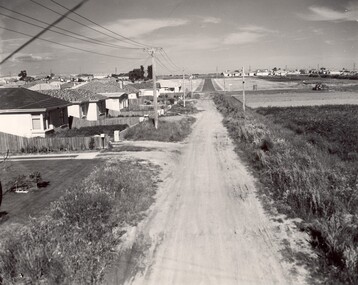
Photograph - Black and white, c. 1960
This image depicts a scene of East Bentleigh in 1960, viewed along Thomasina Street as it crosses Gladwyn Street towards East Boundary Road in the distance. The gardens and new homes are well-tended, but the street surfacing is unsealed.Developing urban area now located within the City of Glen Eira, formally City of Moorabbin. This image illustrates the mid century urban sprawl of new suburbs and the subdivision of market gardens within the municipality and the changing demographic of the district as new houses are constructed and infrastructure established. Black and white photograph of unsealed road in new development in the area of Moorabbin, new houses appear on the lefthand side with paddocks on right side of image with installation of electric poles. Sealed road in the distance. Thomasina Street, as it crosses Gladwyn Street, East Bentleigh towards East Boundary Road. Handwritten in blue ink: 60 - 373 D Handwritten in red ink: 80% Handwritten in black ink: Ch. 6bentleigh, east bentleigh, market garden, housing, suburbs, infrastructure, moorabbin -
 City of Kingston
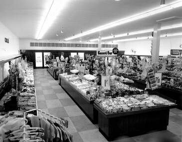
Photograph - Black and white, c. 1956
This photograph depicts the interior of the Coles Variety Store within Bentleigh's Centre Road shopping precinct in 1956. Signage represents the pre decimal currency era. The Record Bar advertises the availability of standard and microgroove vinyl records.In this era, the Centre Road Bentleigh shopping strip provided consumers with access to many of the major retail outlets and provided for a wide range of shopping needs. By the 1960s, Chadstone Shopping Centres (opened 1960) and Southland (opened 1968) had been established which created changes to the way in which people shopped.Black and white photograph of interior of Coles Store in Centre Road, Bentleigh displaying prominent signage predating decimal currency. Other signage includes the Coles Record Bar indicating the sale of standard and microgroove vinyl records.Handwritten in blue ink: Coles Bentleigh Sep 1956 B Black printed text on white round adhesive sticker: 202 Handwritten in red ink: 80%shopping strip, strip shopping, bentleigh, city of moorabbin, coles stores -
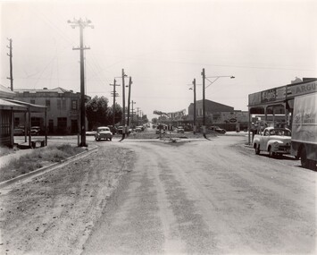
 City of Kingston
Photograph - Black and white
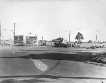
This photograph depicts the road diversion on Nepean Highway that was implemented to allow construction of the railway line underneath the Nepean Highway at Moorabbin. An "Allourie" Cheese, Honey Canned Ham van is prominent on the left of the image, the railway gates are central and the old Moorabbin Station is visble. Beyond the dates, pedestrians are visible crossing the Nepean Highway. This image is part of a larger collection of images from the Public Transport Corporation displaying train stations and streetscapes in what is now the City of Kingston.In 1958 excavations began for the removal of the level crossing gates at the southern end of the Moorabbin shopping centre on Nepean Highway. The station was also lowered below ground. A diversion route was created to enable the flow of traffic in both directions along the highway.Black and white photograph of road diversion on Nepean Highway, Moorabbin to allow the construction of the railway line below the Nepean Highway at Moorabbin and also to trench the station. This image is part of a larger collection of images from the Public Transport Corporation displaying train stations and streetscapes in what is now the City of Kingston.White adhesive dot sticker: Printed black 199 Handwritten in red ink: 80% Handwritten in black ink on yellow Post-It Note: [indecipherable] 199 - Diversion for Crossing Stamped in blue ink: COPYRIGHT Public Transport Corporation, For reordering photographs, Please quote negative No m 5687, Enquiries C/- PTC Photographic Unit, Telephone switchboard 619 1111railway crossing, railway station, city of moorabbin -
 City of Kingston
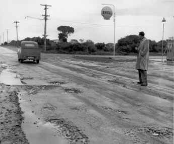
Photograph - Black and white, c. 1950
This image depicts the unsealed roads with potholes prevalent in the quickly developing suburbs of Black Rock and Beaumaris. In the post war era, as the suburbs of Beaumaris and Black Rock grew, the infrastructure for roads was falling behind. The unsealed roads were dusty in summer and muddy with potholes in winter. Drainage was poor and roads difficult to navigate.Black and white photograph of a man standing outside the Shell service station in Balcombe Road, possibly at Beaumaris. He is watching a utility vehicle with registration GFM033 as it drives on the unsealed road through mud and potholes.Handwritten in blue ink: 2195 Handwritten in red ink: 80%roads, infrastructure, beaumaris, black rock, balcombe road -
 City of Kingston
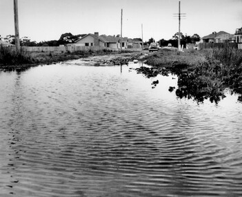
Photograph - Black and white, c. 1958
This photograph depicts flooding of Ozone Avenue in Beaumaris, located off Balcombe Road. Roads in the Beaumaris area lacked sufficient drains to clear surface water. In many cases streets were unsealed and without footpaths and some were dirt tracks. Gutters and road surfaces were made of clay and in the wetter months of winter, unsealed roads and tracks became impossible quagmires that were unnavigable for vehicles and pedestrians. In the first decade after World War II there was rapid expansion in construction of new houses in the suburb of Beaumaris. Utilities and infrastructure to support the growth of housing was inadequate and not provided for prior to the development of the area. Without rudimentary drainage, flooding was frequent. Storm water runoff, domestic sullage and septic tank overflow would form large pools and families were sometimes marooned within their homes. The frequent flooding caused isolation and hardship and residents endured difficulties with accessibility to facilities. These disadvantages had the potential to cause social issues for the new residents.Black and white photograph of flooding in Ozone Avenue, Beaumaris. The image shows floodwaters with boggy and rough terrain on an unsealed road with housing in the distance.Handwritten in blue ink: 2124 circled Handwritten in red ink: 80% Handwritten in blue ink on yellow Post-It note: Chap 6. underlined, 2194 Ozone Ave Beaumaris 1958beaumaris, ozone avenue, balcombe road, flooding, roads, infrastructure -
 City of Kingston
Photograph - Black and white, c. 1970
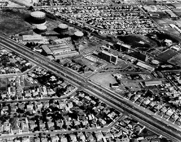
The Highett Gas Works were a landmark along the Nepean Highway for many years. With the cessation of the gasification of coal and the introduction of natural gas to Victoria, the gas holders were demolished and the Sir William Fry Reserve was developed on the southern end of the site. The Gas and Fuel redeveloped the northern end of the site with modern offices and laboratories for the organisation's scientific services. At this time, the chimney and retort house were retained.The Highett Gasworks had its beginning in 1939 operated by the Central Brighton and Moorabbin Gas Co Ltd. The company had expanded its gas production facilities to Highett where it had purchased 45 acres of land adjacent to the Melbourne-Frankston railway line. The first gasholder was erected on the Highett site in 1927 and connected with high pressure mains to the Brighton Gas Works. In 1939 the building program including gasometers, the vertical retort house and coal store was completed and gas making commenced. Its area of supply covered approximately 70 square miles and included the municipalities of Brighton, Sandringham, Moorabbin, Mordialloc, Chelsea and part of Dandenong. The Gas and Fuel Corporation eventually took over operations and with the disaggregation and privatisation of the organisation, the site was eventually closed c. 2002.Black and white aerial photograph featuring the Highett Gas Works with gasholders and retort house. In the top right-hand corner, a former Highett Primary School on Graham Road can be viewed. Photograph includes Bay Road, Royal Avenue, Princess Avenue and Jackson Road (Highett) and Alfred, Turner and Sandford Streets (Moorabbin).Handwritten in black ink: [indecipherable] in a circle Handwritten in red ink: 70% Four velcro display adhesivesgasification of coal, gas and fuel corporation of victoria, gasholders, highett, moorabbin, utilities -
 City of Kingston
Photograph - Black and white, c. 1956
Strip shopping and ample parking were features of suburbs in the middle of the twentieth centuries. Cars were still considered a luxury, although that would soon change, and local, independent shops serviced local areas.During the post-war years, the municipality of Moorabbin experienced a population boom. The 'newcomers' were predominantly returnees from the war who were marrying and establishing families; those from the old inner-suburban areas who were moving away from rented premises to establish their own homes on cheap land. The 1950s were a time of immense growth for the area now known as City of Kingston.Black and white photograph of the intersection of Centre and East Boundary roads, Bentleigh East. Several cars are visible both in the foreground and background, and the intersection includes a roundabout. The street is lined with poles to carry electricity cables, and the roundabout is dotted with four poles for electric street lights.Handwritten in blue ink: 56 - 230 Handwritten in red ink: 82% Handwritten in black ink: Ch. 6shopping strip, cars, suburbs -
 City of Kingston
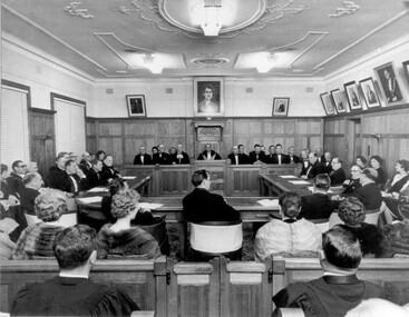
Photograph - Black and white, 1962
Local government for Moorabbin began in 1862 when the area was separated from Brighton with the creation of the Moorabbin Roads Board. This meeting commemorated the centenary of local government in 1962.1862 saw the beginnings of local government in the Moorabbin district when the area was separated from Brighton with the creation of the Moorabbin Roads Board. Moorabbin was declared a shire in 1871 and a city in 1934. While tinkering with boundaries occurred over time, the first major severance from Moorabbin was when the Borough of Sandringham was created in 1917. Three years later, after persistent agitation, on May 27, 1920 Mordialloc, Parkdale and Mentone became part of the new Borough of Mordialloc. With this change the Shire of Moorabbin no longer had authority for land with a frontage to Port Phillip Bay. In 1994 councils across Victoria were amalgamated and the City of Moorabbin was divided between the cities of Kingston and Glen Eira. The City of Kingston is made up the former cities of Chelsea, Mordialloc, Moorabbin, Oakleigh and Springvale.Black and white image of inside of Moorabbin Council Chambers, with a meeting (possibly staged) in progress. Council members are seated behind a bench which connects to a horseshoe shaped table. All in attendance are in formal attire. Men are wearing black tie and the women in the audience (with backs to camera) are wearing fur coats or stoles.Black printed text of white round sticker adhered to reverse: 191 Handwritten in red ink: 80%moorabbin, council, chambers, council meeting, centenary -
 City of Kingston
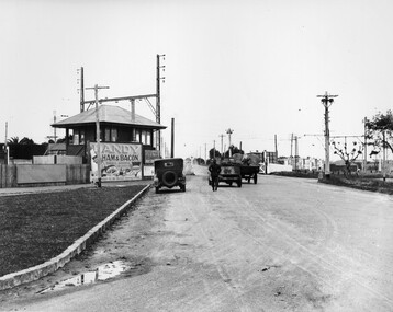
Photograph - Black and white, c. 1930
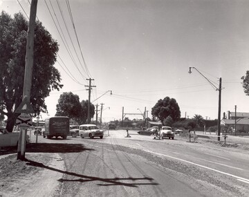
This image is part of a larger collection of images from the Public Transport Corporation displaying train stations and streetscapes in what is now the City of Kingston.The Nepean Highway is a major highway running through the City of Kingston. This image is one of many that depicts its importance to the local community as it undergoes many changes over time.Black and white photograph depicting the level crossing at Moorabbin. While the gates at the level crossing are open, two cars are making their way across the crossing, while a third car is parked on the side of the road, in front of a large billboard/hoarding for ham and bacon products. There is a man standing on the road as if watching the cars go through the crossing. The road appears to be unsealed. Black printed text on a round white sticker adhered to the reverse: 148 Handwritten in red ink: 60% Blue ink stamped on reverse: COPYRIGHT / Public Transport Corporation / For re-ordering photographs / Please quote negative No ADU907 / Enquiries C/- PTC Photographic Unit / Telephone switchboard 619 111moorabbin, trains, railway crossing, level crossing, cars, roads, nepean highway -
 City of Kingston
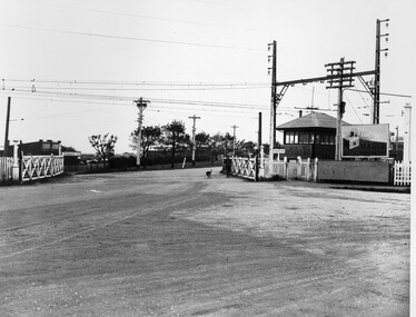
Photograph - Black and white, c. 1930
This image is part of a larger collection of images from the Public Transport Corporation displaying train stations and streetscapes in what is now the City of Kingston.The Nepean Highway is a major highway running through the City of Kingston. This image is one of many that depicts its importance to the local community as it undergoes many changes over time.Black and white photograph depicting railway crossing at Nepean Highway Moorabbin. The level crossing gates are open and a man is walking through with his dog. To the right of the crossing is a billboard/hoarding promoting what appears to be a brand of radio/wireless.White round sticker with indecipherable black printed text which has been scribbled over with black pen. White round sticker with black printed text: 175 Handwritten in red ink: 50% Blue ink stamped on reverse: COPYRIGHT / Public Transport Corporation / For re-ordering photographs / Please quote negative No ADV 903 / Enquiries C/- PTC Photographic Unit / Telephone switchboard 619 111moorabbin, trains, railway crossing, level crossing, nepean highway -
 City of Kingston
Photograph - Black and white, c. 1930
This image is part of a larger collection of images from the Public Transport Corporation displaying train stations and streetscapes in what is now the City of Kingston.The Nepean Highway is a major highway running through the City of Kingston. This image is one of many that depicts its importance to the local community as it undergoes many changes over time.Black and white photograph of the level crossing at Neapean Highway Moorabbin. Photograph is a slightly side view, with a blurred image of a car approaching the level crossing. The gates are closed. To the left of the image is a pair of billboards. The billboard on the left is promoting Creamoata, a New Zealand brand of oats, and the billboard on the right is promoting Kraft cheese.White round sticker on reverse with black printed text: 147 Handwritten in red ink on reverse: 100% Blue ink stamped on reverse: COPYRIGHT / Public Transport Corporation / For re-ordering photographs / Please quote negative No ADV 1030 / Enquiries C/- PTC Photographic Unit / Telephone switchboard 619 111moorabbin, level crossing, railway crossing, cars, advertising, nepean highway -
 City of Kingston
Photograph - Black and white, c. 1920
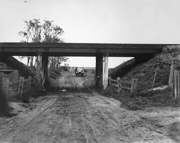
This image is part of a larger collection of images from the Public Transport Corporation displaying train stations and streetscapes in what is now the City of Kingston.While the focus of this image is the train line running overhead, the unsealed nature of the road speaks to the progression of suburban development during the 1920s.Black and white image of an unsealed underpass at Patterson Road, looking west. A car has stopped on the road in the distance and man is standing on the duckboard leaning into the car.Round white sticker on reverse with black printed text: 177 Handwritten in red ink: 60% Blue ink stamped on reverse: COPYRIGHT / Public Transport Corporation / For re-ordering photographs / Please quote negative No ADV 300 / Enquiries C/- PTC Photographic Unit / Telephone switchboard 619 111patterson road, railway, trains, cars, unsealed roads -
 City of Kingston
Photograph - Black and white, c. 1930
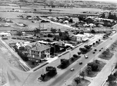
During the 1930s Moorabbin was an area with open grasslands, still often used for market gardening. The development of the city (and, later, suburb) can be seen emerging from the railway station.The Nepean Highway is a major highway running through the City of Kingston. This image is one of many that depicts its importance to the local community as it undergoes many changes over time.Black and white photograph of aerial view of intersection of Nepean Highway and South Road. Moorabbin Council Chambers are situated on the corner with the library, old shire building, Moorabbin railway station, St David's Anglican Church market gardens and open paddocks in the background.White round sticker on reverse with black printed text: 143 Handwritten in red ink on reverse: 156% / k000786moorabbin, council, railway station, railway, suburbs, paddocks, nepean highway -
 City of Kingston
Photograph - Black and white, c. 1950
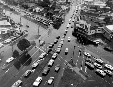
The image shows a line of traffic travelling along South Road in response to traffic light signlas while an increasing number of cars are banking up along Nepean Highway, also in response to traffic light signals.This image provides a strong contrast to images from earlier eras of the same intersection. The amount of traffic has increased enormously as well as commercial development.Black and white photograph with an aerial view of the intersection of Nepean Highway and South Road, taken from above the Moorabbin Council Chambers.Handwritten in black ink Pic [indecipherable] / 1000 Handwritten in red ink: 150%moorabbin, traffic lights, cars, nepean highway -
 City of Kingston
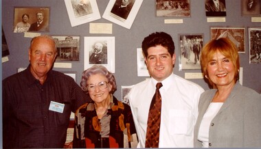
Photograph - Colour, 2000
Narratives of Kingston was an oral history project where the personal memories of residents were collected and compiled into a reference book. The image suggests there was also an exhibition of personal photographs as the people depicted are standing in front of photo boards.Colour photograph taken at the launch of the Narratives of Kingston project. Depicted in the image (L to R) are Ron Jacobs, President Chelsea Historical Society, Sylvia Roberts, granddaughter of Roderick Mills/Saltbush Bill, Mayor Arthur Athanasopoulos, and Piri White, member of the Narratives team. People pictured are standing in front of a photo board.Handwritten in red ink on reverse: K000740.tif Launch of Narratives of Kingston / Ron Jacobs - Presidetn Chelsea Hist Soc / Sylvia Roberts - granddaughter of / Roderick Mills/Saltbush Bill / Mayor Arthur - Mayor of Kingston / Piri White - member of Narratives Teamoral history, kingston