Showing 11008 items matching " land"
-
 Mt Dandenong & District Historical Society Inc.
Photograph
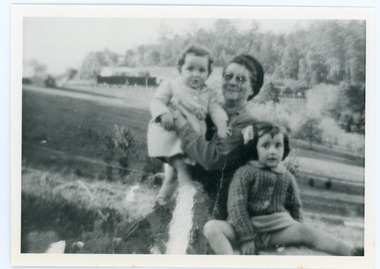
The Wenborn family acquired Ferguson's Lot 19 of the Village Settlement where the original Mount Dandenong School was opened in a shed. WH Collom owned the land after Ferguson and then it passes to the Wenborns. This photograph, taken c1942, shows Ivy Wenborn with her daughters Mary and Joan. John Lundy-Clarke grew up in the Kalorama/Mt Dandenong area and later in life (1972-74) began to write a comprehensive history of the area working from an original settlement map in an effort to cover all areas.Black and white photograph of a woman nursing a young girl Another young girl is seated at her right.Behind is a view of trees and a house. Handwritten inscription on reverse by John Lundy-ClarkeWenborn Family. Looking across what is now Kalorama Park showing Norman Jeeves' house behind the hedge to the left of the child.wenborn, ivy wenborn, mary wenborn, joan wenborn, norman jeeves, kalorama park, jeeves -
 8th/13th Victorian Mounted Rifles Regimental Collection
Photograph - Moving Centurion
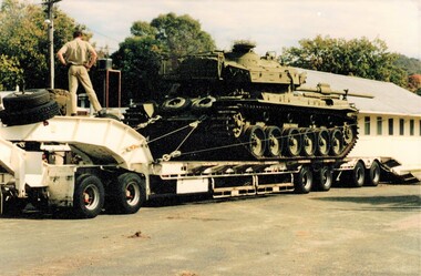
In May 2000, the Victorian Mounted Rifles Squadron 4/19 Prince of Wales's Light Horse relocated from its depot, Buna Barracks Albury to a new depot at Building 105 North Bandiana. The relocation included the regiment's heritage collection, and its heritage vehicles needed to be moved. Buna Barracks had been home to the 8/13 VMR since 1948, and to the city's citizen soldiers for fifty years prior to that. Following the move the historic Drill Hall was demolished and the land sold for residential development. Colour photograph of a Centurion tank loaded onto a low-loader trailer during the relocation from Buna Barracks Albury to North Bandiana May 2000.vmr, centurion, pwlh -
 Queenscliffe Maritime Museum
Instrument - Binnacle Compass
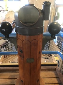
Built in 1914 by Fleming and Ferguson in Paisley Scotland as Sir William Matthews for the Ceylon Government, she was a twin screwed steam bucket dredge. She was purchased from the Western Australian Government by the Melbourne Harbour Trust on 10 October 1941. After an extensive overhaul, the vessel was renamed the George Kermode and commenced operation in Victorian waters on 22 June 1942. The George Kermode was scuttled by the Department of Conservation, Forests and Land off Phillip Island on the 1 April 1976 as part of an artificial reef program. This vessel was used to dredge the Port Phillip channels from 1942 and is of cultural significance to Queenscliffe.Binnacle compass from the 'George Kermode'Compass No. 3127N Sestrel Type 89098bucket dredge, port phillip, melbourne harbour trust -
 Kew Historical Society Inc
Photograph - 'Fernhurst', 13 Fernhurst Grove, 1978
George Wharton arrived in Melbourne in 1844. An architect and surveyor, he was appointed to lay out the 'Village of Kew' by N.A. Fenwick following the land sales of 1851. A protagonist for Kew's separation from the Boroondara District Road Board, he was elected chairman when Kew achieved municipal status in December 1860. His home, 'Fernhurst', was built in 1866 on eight acres in Studley Park, with a four-storey tower and pyramidal roof. The Italianate home was a prominent Kew landmark. It was demolished in 1979 and replaced by St Paul's College in 1980.Rare colour photograph of what was once a significant mansion in Kew.Original colour positive photograph (Kodak print) of 'Fernhurst' in 1978. Photographed by Stewart West in May 1978, one year before it was demolished, the photograph gives little idea of the large landholding once surrounding the house. Originally accessed from near the corner of Princess Street and Studley Park Road, its gardens had been subdivided in the 1900s and its footprint restricted to 13 Fernhurst Grove. Like many other grand houses, by the 1970s it had been converted into apartments. From the photograph, one can see that the house had retained many of its original features such as the distinctive tower and the wide bow-fronted verandah. The slates on the roof (apart from those on the tower) had been replaced by tiles and the cement render of the exterior painted white. Annotated reverse: "View of Fernhurst Home Taken from Street / 10"fernhurst, 13 fernhurst grove -- kew (vic.), george wharton, italianate architecture, vila maria society, st paul's school for the blind -
 Kew Historical Society Inc
Photograph - 'Fernhurst', 13 Fernhurst Grove, 1978
George Wharton arrived in Melbourne in 1844. An architect and surveyor, he was appointed to lay out the 'Village of Kew' by N.A. Fenwick following the land sales of 1851. A protagonist for Kew's separation from the Boroondara District Road Board, he was elected chairman when Kew achieved municipal status in December 1860. His home, 'Fernhurst', was built in 1866 on eight acres in Studley Park, with a four-storey tower and pyramidal roof. The Italianate home was a prominent Kew landmark. It was demolished in 1979 and replaced by St Paul's College in 1980.Rare colour photograph of what was once a significant mansion in Kew.Original colour positive photograph (Kodak print) of 'Fernhurst' in 1978. Photographed by Stewart West in May 1978, one year before it was demolished, the photograph gives little idea of the large landholding once surrounding the house. Originally accessed from near the corner of Princess Street and Studley Park Road, its gardens had been subdivided in the 1900s and its footprint restricted to 13 Fernhurst Grove. Like many other grand houses, by the 1970s it had been converted into apartments. From the photograph, one can see that the house had retained many of its original features such as the distinctive tower and the wide bow-fronted verandah. The slates on the roof (apart from those on the tower) had been replaced by tiles and the cement render of the exterior painted white. Annotated reverse: "Fernhurst from higher ground level side shot / 7"fernhurst, 13 fernhurst grove -- kew (vic.), george wharton, italianate architecture, vila maria society, st paul's school for the blind -
 Kew Historical Society Inc
Photograph - 'Fernhurst', 13 Fernhurst Grove, 1978
George Wharton arrived in Melbourne in 1844. An architect and surveyor, he was appointed to lay out the 'Village of Kew' by N.A. Fenwick following the land sales of 1851. A protagonist for Kew's separation from the Boroondara District Road Board, he was elected chairman when Kew achieved municipal status in December 1860. His home, 'Fernhurst', was built in 1866 on eight acres in Studley Park, with a four-storey tower and pyramidal roof. The Italianate home was a prominent Kew landmark. It was demolished in 1979 and replaced by St Paul's College in 1980.Rare colour photograph of what was once a significant mansion in Kew.Original colour positive photograph (Kodak print) of 'Fernhurst' in 1978. Photographed by Stewart West in May 1978, one year before it was demolished, the photograph gives little idea of the large landholding once surrounding the house. Originally accessed from near the corner of Princess Street and Studley Park Road, its gardens had been subdivided in the 1900s and its footprint restricted to 13 Fernhurst Grove. Like many other grand houses, by the 1970s it had been converted into apartments. From the photograph, one can see that the house had retained many of its original features such as the distinctive tower and the wide bow-fronted verandah. The slates on the roof (apart from those on the tower) had been replaced by tiles and the cement render of the exterior painted white. Annotated reverse: "Back view of Fernhurst / 8"fernhurst, 13 fernhurst grove -- kew (vic.), george wharton, italianate architecture, vila maria society, st paul's school for the blind -
 Kew Historical Society Inc
Photograph - 'Fernhurst', 13 Fernhurst Grove, 1978
George Wharton arrived in Melbourne in 1844. An architect and surveyor, he was appointed to lay out the 'Village of Kew' by N.A. Fenwick following the land sales of 1851. A protagonist for Kew's separation from the Boroondara District Road Board, he was elected chairman when Kew achieved municipal status in December 1860. His home, 'Fernhurst', was built in 1866 on eight acres in Studley Park, with a four-storey tower and pyramidal roof. The Italianate home was a prominent Kew landmark. It was demolished in 1979 and replaced by St Paul's College in 1980.Rare colour photograph of what was once a significant mansion in Kew.Original colour positive photograph (Kodak print) of 'Fernhurst' in 1978. Photographed by Stewart West in May 1978, one year before it was demolished, the photograph gives little idea of the large landholding once surrounding the house. Originally accessed from near the corner of Princess Street and Studley Park Road, its gardens had been subdivided in the 1900s and its footprint restricted to 13 Fernhurst Grove. Like many other grand houses, by the 1970s it had been converted into apartments. From the photograph, one can see that the house had retained many of its original features such as the distinctive tower and the wide bow-fronted verandah. The slates on the roof (apart from those on the tower) had been replaced by tiles and the cement render of the exterior painted white. Annotated reverse: "Fernhurst front view taken from across Fernhurst Grove / 6"fernhurst, 13 fernhurst grove -- kew (vic.), george wharton, italianate architecture, vila maria society, st paul's school for the blind -
 Kew Historical Society Inc
Photograph - 'Fernhurst', 13 Fernhurst Grove, 1978
George Wharton arrived in Melbourne in 1844. An architect and surveyor, he was appointed to lay out the 'Village of Kew' by N.A. Fenwick following the land sales of 1851. A protagonist for Kew's separation from the Boroondara District Road Board, he was elected chairman when Kew achieved municipal status in December 1860. His home, 'Fernhurst', was built in 1866 on eight acres in Studley Park, with a four-storey tower and pyramidal roof. The Italianate home was a prominent Kew landmark. It was demolished in 1979 and replaced by St Paul's College in 1980.Rare colour photograph of what was once a significant mansion in Kew.Original colour positive photograph (Kodak print) of 'Fernhurst' in 1978. Photographed by Stewart West in May 1978, one year before it was demolished, the photograph gives little idea of the large landholding once surrounding the house. Originally accessed from near the corner of Princess Street and Studley Park Road, its gardens had been subdivided in the 1900s and its footprint restricted to 13 Fernhurst Grove. Like many other grand houses, by the 1970s it had been converted into apartments. From the photograph, one can see that the house had retained many of its original features such as the distinctive tower and the wide bow-fronted verandah. The slates on the roof (apart from those on the tower) had been replaced by tiles and the cement render of the exterior painted white. Annotated reverse: "Front view of Fernhurst showing tower to advantage / 9"fernhurst, 13 fernhurst grove -- kew (vic.), george wharton, italianate architecture, vila maria society, st paul's school for the blind -
 Kew Historical Society Inc
Photograph - 'Fernhurst', 13 Fernhurst Grove, 1978
George Wharton arrived in Melbourne in 1844. An architect and surveyor, he was appointed to lay out the 'Village of Kew' by N.A. Fenwick following the land sales of 1851. A protagonist for Kew's separation from the Boroondara District Road Board, he was elected chairman when Kew achieved municipal status in December 1860. His home, 'Fernhurst', was built in 1866 on eight acres in Studley Park, with a four-storey tower and pyramidal roof. The Italianate home was a prominent Kew landmark. It was demolished in 1979 and replaced by St Paul's College in 1980.Rare colour photograph of what was once a significant mansion in Kew.Original colour positive photograph (Kodak print) of 'Fernhurst' in 1978. Photographed by Stewart West in May 1978, one year before it was demolished, the photograph gives little idea of the large landholding once surrounding the house. Originally accessed from near the corner of Princess Street and Studley Park Road, its gardens had been subdivided in the 1900s and its footprint restricted to 13 Fernhurst Grove. Like many other grand houses, by the 1970s it had been converted into apartments. From the photograph, one can see that the house had retained many of its original features such as the distinctive tower and the wide bow-fronted verandah. The slates on the roof (apart from those on the tower) had been replaced by tiles and the cement render of the exterior painted white. Annotated reverse: "Fernhurst corner shot through trees / 12-22"fernhurst, 13 fernhurst grove -- kew (vic.), george wharton, italianate architecture, vila maria society, st paul's school for the blind -
![Congregational Church, Walpole Street [Kew], 1977](/media/collectors/550653872162f11fb04854aa/items/58ce2f27d0ce2909d88dffec/item-media/58cf5dbbd0ce9d3314c36111/item-fit-380x285.jpg) Kew Historical Society Inc
Kew Historical Society IncPhotograph, Unknown, Congregational Church, Walpole Street, 1977
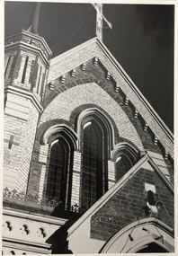
The Congregational Church was built on the site of the first church in Kew. This church, the second on the site, was designed by the Kew architect Charles Vickers and opened in 1860. The distinctive polychrome brick façade designed by Vickers contrasted with the style that he employed for other churches he designed during this period; they were usually constructed in bluestone. In the 1960s, a new ministry saw the erection of a neon cross at the apex of the church. The illuminated cross could be seen from Church Street, Hawthorn. The church was later to be demolished, and the land sold for the construction of modern villas. The Kew Historical Society's Pictures Collection is comprised of photographs, postcards and original works of art. The photographs include original (mainly) images dating from the 1870s to the present. A number of these photographs derive from the former City of Kew's Civic Collection while others are the work of amateur and professional photographers. Most of the images in the collection depict people, places and objects within the suburbs of Kew and Kew East. Other photographs depict other locations in Melbourne and Victoria. A number of the photographs are of statewide and/or national significance.Congregational Church, Walpole Street, Kew, 1977 (now demolished). View of the polychrome facade facing Walpole Street. The use of polychrome brick by Alfred Purchas (the second architect) reflects his preference for this architectural style, such as in his design for Tarring (now Ruyton Girls' School)Inscriptions on reverse: "KH-99. Congregational Church Walpole St Kew. Built 1854. Now amalgamated with United Churches 1977."congregational church, walpole street (kew), charles vickers -
![Congregational Church, Walpole Street [Kew], 1977](/media/collectors/550653872162f11fb04854aa/items/58ce3037d0ce2f09d89eafac/item-media/58cf5d86d0ce9a3314909edb/item-fit-380x285.jpg) Kew Historical Society Inc
Kew Historical Society IncPhotograph, Unknown, Congregational Church, Walpole Street, 1977
The Congregational Church was built on the site of the first church in Kew. This church, the second on the site, was designed by the Kew architect Charles Vickers and opened in 1860. The distinctive polychrome brick façade designed by Vickers contrasted with the style that he employed for other churches he designed during this period; they were usually constructed in bluestone. In the 1960s, a new ministry saw the erection of a neon cross at the apex of the church. The illuminated cross could be seen from Church Street, Hawthorn. The church was later to be demolished, and the land sold for the construction of modern villas. Photograph of an historic church in Kew by noted architects Charles Vickers and Alfred Purchas.Congregational Church, Walpole Street, Kew, 1977 (now demolished). View of the polychrome facade facing Walpole Street. The use of polychrome brick by Alfred Purchas (the second architect) reflects his preference for this architectural style, such as in his design for Tarring (now Ruyton Girls' School)Inscriptions on reverse: "KH-100. Congregational Church Walpole St Kew. First church built in Kew 1860. Chapel on site 1854. Became a member of the United Churches 1970s". congregational church, walpole street (kew), charles vickers -
 Kew Historical Society Inc
Photograph, Congregational Church, Walpole Street, 1977
The Congregational Church was built on the site of the first church in Kew. This church, the second on the site, was designed by the Kew architect Charles Vickers and opened in 1860. The distinctive polychrome brick façade designed by Vickers contrasted with the style that he employed for other churches he designed during this period; they were usually constructed in bluestone. In the 1960s, a new ministry saw the erection of a neon cross at the apex of the church. The illuminated cross could be seen from Church Street, Hawthorn. The church was later to be demolished, and the land sold for the construction of modern villas.Congregational Church, Walpole Street, Kew, 1977 (now demolished). View of the polychrome facade facing Walpole Street. The use of polychrome brick by Alfred Purchas (the second architect) reflects his preference for this architectural style, such as in his design for Tarring (now Ruyton Girls' School) Inscriptions on reverse: "K.H.701. Congregational Church Walpole St Kew. First church in Kew. Now amalgamated with the United Churches."congregational church, walpole street (kew), charles vickers -
 Sunbury Family History and Heritage Society Inc.
Photograph, 18 October 1978
George and Anne Evans settled in Sunbury in 1836 after migrating to Van Diemens Land from Plymouth in 1825. He took upland along the Jacksons Creek and built his Emu Bottom Homestead. He married Anne, who was forty years younger than him on 11 May 1843 and they had six children. He and his wife Anne are buried in Melbourne General Cemetery in Compartment 'H'.George died on 26 August 1876 and Anne died on 12 January 1893. George Evans was a one of the first Europeans to take up land in the the area that was originally known as Buttlejork ( Batterjork) in the area now known as Sunbury. A black and white photograph with a cream border of the headstone of George and Anne Evans.evans, george., evans, anne., emu bottom, headstones -
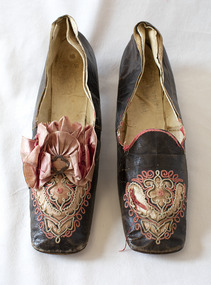 Brighton Historical Society
Shoes, circa 1867
These shoes were worn by Emily Cock (nee Smith), the daughter of wealthy early settler John Matthew Smith. From 1856 until 1931 the Smiths lived at 'Castlefield', a mansion on a vast estate that at one time stretched along South Road from Bluff Road to Hampton Street. The land was gradually subdivided, and the house is now a part of Haileybury College. Julien Mayer was a French ladies shoemaker and prolific exporter who advertised his successes on the shoes themselves by stamping the soles with details of the prizes he had won.Pair of black kid leather shoes with low block heel, decorated with pink silk, cut-away applique and embroidery. Pink bow with metal clasp on one shoe; missing from the other. Edged with pink silk ribbon binding, largely deteriorated.Sole embossed with "MAYER / Julien / à Paris", in addition to tamped with three small medallions proclaiming the awards the shoemaker won in London in 1862, Porto in 1865 and Paris in 1867. Handwritten in interior sole of T0124.2 in pencil: "Emily Smith / Castlefield"emily smith, castlefield, shoes, 1860s, applique, embroidery, julien mayer -
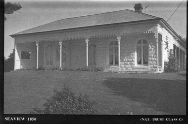 Port Fairy Historical Society Museum and Archives
Souvenir - Postcard, Seaview 1850
The construction of Seaview commenced in 1860, after David Talbot, purchased the land from James Atkinson,It had been suggested that it was intended to be double storied but there is no evidence of how that would have been accomplished. Following Talbot’s insolvency, Michael O’Reilly leased the house in 1862 until 1876 when he left for Melbourne.William Powling (Solicitor) acquired the house for Eight hundred and twenty three pounds in 1890 and lived there the rest of his life. His son Ernest Powling continued living there before selling it to Matthew Cathcart in 1917.A black and white photograph of the house called Seaview to be used as a postcard in a series by the National Trust Front of Seaview showing bay window and verandah bluestone painted whiteSeaview 1850 - Nat.Trust. CL1souvenir, port-fairy, seaview, powling, cathcart, talbot, o’reilly, house -
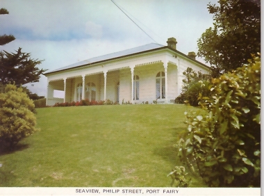 Port Fairy Historical Society Museum and Archives
Postcard, Seaview Philip Street Port Fairy
The construction of Seaview commenced in 1860, after David Talbot, purchased the land from James Atkinson,It had been suggested that it was intended to be double storied but there is no evidence of how that would have been accomplished. Following Talbot’s insolvency, Michael O’Reilly leased the house in 1862 until 1876 when he left for Melbourne.William Powling (Solicitor) acquired the house for Eight hundred and twenty three pounds in 1890 and lived there the rest of his life. His son Ernest Powling continued living there before selling it to Matthew Cathcart in 1917.Coloured photograph of Front of Seaview showing bay window and verandahsouvenir, port-fairy, seaview, philip street, house -
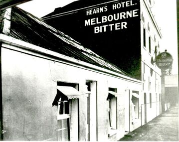 Port Fairy Historical Society Museum and Archives
Photograph
Tennysons Hotel Sackville Street Port Fairy Patrick Tennyson leased the Farmers Inn in 1882 and applied to change the name to Tennysons Hotel. In 1885 he bought the freehold in the Great Land Sale for 780 pounds.12 shillings and 8 pence and then carried out extensive renovations. The double storied addition was added in 1893. The hotel continued under various licensees until it burned down in 1977 under the name "Fishermen's Arms". This photograph was taken during the licencee W J Wright; the single story was the Farmers InnBlack and white photograph of facade of Hearn’s hotel with two advertising signs for beerhotel, sackville street, tennysons hotel, farmers inn, fishermen’s arms, inn, w.j.wright, patrick tennyson -
 Vision Australia
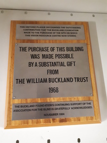
Image, The William Buckland Trust 1968, 1994
The William Buckland Trust (now Foundation) provides support for disadvantaged Victorians through support for four key areas. The growing need for space at the Association for the Blind's offices in Kooyong was constraining the amount of people who could benefit from it's programs. With the assistance of the William Buckland and Hecht Trusts, the adjoining blocks of flats fronting Glenferrie Road were acquired and eventually demolished to make way for the Vision Resource Centre. The support from the Buckland Trust in 1968 was not forgotten however, and this plaque acknowledges the support gained in purchasing the land.Digital image of metal plaques attached to a boardThis historic plaque recognises the outstanding contribution that the Buckland Foundation made to the purchase of the site on which the Vision Resource Centre now stands. The purchase of this building was made possible by a substantial gift from the William Buckland Trust 1968. The Buckland Foundation's continuing support of the Association for the Blind is gratefully acknowledged. November 1994.association for the blind, h & l hecht trust, william buckland trust -
 Port Fairy Historical Society Museum and Archives
Photograph
The construction of Seaview commenced in 1860, after David Talbot, purchased the land from James Atkinson,It had been suggested that it was intended to be double storied but there is no evidence of how that would have been accomplished. Following Talbot’s insolvency, Michael O’Reilly leased the house in 1862 until 1876 when he left for Melbourne.William Powling (Solicitor) acquired the house for Eight hundred and twenty three pounds in 1890 and lived there the rest of his life. His son Ernest Powling continued living there before selling it to Matthew Cathcart in 1917.Coloured photograph of White painted stone house with bay window to right and large verandahcottage, building, home, house, seaview -
 Port Fairy Historical Society Museum and Archives
Negative - Photograph
The construction of Seaview commenced in 1860, after David Talbot, purchased the land from James Atkinson,It had been suggested that it was intended to be double storied but there is no evidence of how that would have been accomplished. Following Talbot’s insolvency, Michael O’Reilly leased the house in 1862 until 1876 when he left for Melbourne.William Powling (Solicitor) acquired the house for Eight hundred and twenty three pounds in 1890 and lived there the rest of his life. His son Ernest Powling continued living there before selling it to Matthew Cathcart in 1917.negative, seaview, house -
 The Beechworth Burke Museum Research Collection
Card (Series) - Index Card, George Tibbits, 11 William Street, Beechworth, 1976
George Tibbits, University of Melbourne. Faculty of Architecture, Building and Town & Regional PlanningIndex system that support the research for Beechworth : historical reconstruction / [by] George Tibbits ... [et al]Arranged by street names of BeechworthEach index card includes: street name and number of property, image of property, allotment and section number, property owners and dates of ownership, description of the property according to rate records, property floor plan with dimensions.beechworth, george tibbitsbeechworth, george tibbits -
 The Beechworth Burke Museum Research Collection
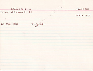
Card (Series) - Index Card, George Tibbits, Ford Street, Beechworth, 1976
George Tibbits, University of Melbourne. Faculty of Architecture, Building and Town & Regional PlanningIndex system that support the research for Beechworth : historical reconstruction / [by] George Tibbits ... [et al]Arranged by street names of BeechworthEach index card includes: street name and number of property, image of property, allotment and section number, property owners and dates of ownership, description of the property according to rate records, property floor plan with dimensions.beechworth, george tibbitsbeechworth, george tibbits -
 The Beechworth Burke Museum Research Collection
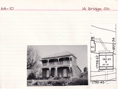
Card (Series) - Index Card, George Tibbits, 14 Bridge Street, Beechworth, 1976
George Tibbits, University of Melbourne. Faculty of Architecture, Building and Town & Regional PlanningIndex system that support the research for Beechworth : historical reconstruction / [by] George Tibbits ... [et al]Arranged by street names of BeechworthEach index card includes: street name and number of property, image of property, allotment and section number, property owners and dates of ownership, description of the property according to rate records, property floor plan with dimensions.beechworth, george tibbitsbeechworth, george tibbits -
 Harcourt Valley Heritage & Tourist Centre
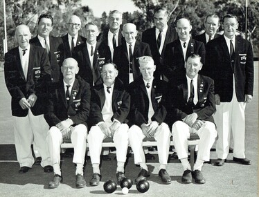
B & W photograph of fourteen men dressed in bowls club uniforms, Harcourt Bowling Club BDBA Pennant Winner Division 3 Season 1966-67, 1967
The inaugural meeting to form Harcourt Bowling Club was held in May 1955. Cr Ben Bingham donated half an acre of land in Bagshaw st Harcourt and the club acquired a small building from Blight's Quarry to serve as a clubhouse. The first day's play took place on 24th October 1959. New clubrooms were built in 1961 with the official opening of the Club held on Saturday 11th November 1961. The club became affilaited with Bendigo District Bowling Assocaition and, in 1966/67 won the Associated division 3 pennant. ; Depicts a group of men, the core ‘movers and shakers’ of the Harcourt community, in the course of their favourite recreation, Association champions in just the seventh year after formation.. Black and white photograph of fourteen men dressed in collar and tie, white trousers and dark blazers, each bearing the club name, HARCOURT BOWLING CLUB B.D.B.A. PENNANT WINNER - DIVISION 3- SEASON 1966-67 and the names of each player. -
 Linton and District Historical Society Inc
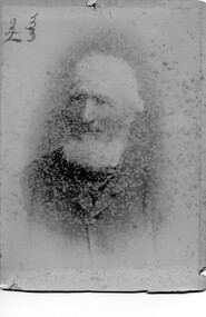
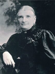
Photograph, Mr William Ching Snr
William Ching and his wife Mary migrated from Cornwall to Victoria in 1853. They lived at Buninyong and Geelong before buying farm land at Linton/Happy Valley. The Ching farm was known as 'Ophir Farm'. William Ching died 1917 at Linton age 89. His wife Mary Ching died 1894 age 64 at Linton. William, Mary, and their children Francis William Ching, Mary Ann Ching, and Godiva Marion Ching are all buried at Linton cemetery. Photograph is part of Old Lintonian collection ; No. 23 Sepia photograph of and old white haired bearded man wearing suit.mr william ching snr., old lintonian collection, mary ching -
 Eltham District Historical Society Inc
Document - Folder, Rosier, James Watson and descendants
James Watson Rosier purchased a block in Little Eltham in 1850 and married Nancy or Elizabeth Richards in 1856. Contents Letter Judy Gibson to EHDS, 7 April 1991: Seeks information about James Watson Rosier. Note Sue Law, 9 February 2010: Information about Rosier and Peers sent to Lois Sinclair. Email exchange Malcolm and Wendy Rosier, Nillumbik Historical Society and EDHS, March-May 2016: Information about James Rosier and land purchased in Little Eltham in 1850. Newspaper clippings, A4 photocopies, etcjames watson rosier, nancy rosier nee richards, samual horace richards rosier, carlton and united breweries, little eltham, josiah holloway, humphrey peers, diamond creek, elizabeth rosier, george rosier, thomas rosier -
 Linton and District Historical Society Inc
Photograph, Anna Rankin
Anna Woods, 1848-1920, was a daughter of James Burns Woods and his wife Anna, née Coates. The Woods family migrated to Victoria in 1864. In 1974, Anna married Ewen Rankin, who held land adjoining her father's property near Linton. Ewen and Anna build a house which they called 'Glenree'. Anna and Ewen Rankin had eight children - Catherine (Kate), James, John, Anna, Mary, Lucy, William (Bill) and Ewen. The Rankins were active members of the Presbyterian congregation in Linton.Black and white photograph which shows a woman wearing a dark dress with full sleeves and a wide decorative collar. A small brooch is pinned on the collar. The woman's hair is parted in the centre and drawn back. Anna Rankin née Woods.anna rankin (née woods) -
 Greensborough Historical Society
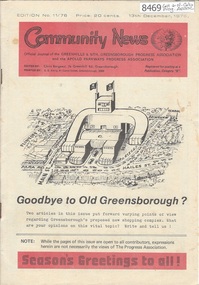
Newsletter, Greenhills and North Greensborough Progress Association, Community News: official journal of the Greenhills and Nth. Greensborough Progress Association and the Apollo Parkways Progress Association.13th December, 1976. Edition No. 11/76, 13/12/1976
This edition includes a report on the The Apollo Parkways Progress Association's November 1976 meeting, Goodbye to old Greensborough?, Lament for the loss of my loved one - Greensborough, Is bigger best?, Church of Christ, This and That, A breeding success story, Cameo of Eric and Prisca Rosario, Land of the brave & the free, Grief, Nursing Mothers Association, Parent Australia, From the Council Chamber, School news, Scout news, Plenty Valley Squash Club, Bird survey of Yandell Reserve. A digital copy of this Newsletter is available from Greensborough Historical Society. Newsletter, 24 p., illus., map.greenhills and north greensborough progress association, greenhills, apollo parkways progress association, apollo parkways -
 Falls Creek Historical Society
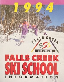
Booklet - Falls Creek Ski School 1994
Part of yearly marketing and information material promoting the Falls Creek Ski School. This publication includes detailed information about the Falls Creek Ski School and its wide range of programs for 1994. Activities include Kids Ski Land, NASTAR Recreational racing, Ski School Race program as well as an extensive snowboarding program. Family night skiing was available for the first time. Special events included the Ski School International Ball, a TELEMARK and Powderhound Women's program as well as a Kangaroo Hoppet Preparation Clinic.This item is important because it documents seasonal activities at Falls Creek Alpine Resort across all age groups.A glossy booklet featuring images and information about programs to be offered at Falls Creek in the 1994 winter season. The front cover features a photo of two downhill skiers at Falls Creek Ski School. Coloured images are included throughout the booklet. Each page has a different coloured background and black or white text.On Cover: 1994 Falls Creek Ski School SSS FALLS CREEK SKI SCHOOL INFORMATIONfalls creek marketing, falls creek ski school, falls creek ski academy, falls creek race club -
 Stawell Historical Society Inc
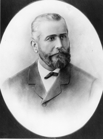
Photograph, Portrait of Mr Jean Pierre Trouette -- Studio Portrait
Portrait of Jean Pierre Trouette who planted vines at St Peters Great Western 1862. Jean Pierre Trouette, was a Frenchman who had difficulty obtaining a block of land at Great Western about 1862. He was permitted to purchase a small allotment on the Concongella Creek in 1863. In 1863 Jean Pierre and Mr. Blampied began planting grape vines. The winery that Trouette and Blampied established was called St Peters. Jean Pierre was Shire President in 1876. E. Blampied was also Shire President in 1887.Black and white photograph setting oval in a rectangle, mounted in a brown folder. The male is neatly dressed, trimmed hair and beard.great western shire president