Showing 8647 items matching "bridge-spike"
-
 Ballarat Tramway Museum
Document, Gold Museum, Royal visit tram 38, 1990's
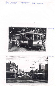
Yields information about the photographic holdings of the Gold Museum, an din particular the preparation of No. 38 decorated for the Royal visit of 1954 and Bridge St Ballarat.Photocopy of two photographs from the Gold Museum Tramways Map Cabinet: 80-020b - No. 38 in Wendouree Parade, at depot junction receiving finishing touches in March 1954, prior to the Royal visit - See Reg Item 412 for a photo in Lydiard St Nth and other items. 80-020c - Bridge St looking West from Stones Comer, shows tram track, parked cars.Along top edge "Gold Museum Tramways Map Cabinet"trams, tramways, ballarat, royal visit, decorated trams, bridge st -
 Ballarat Tramway Museum
Photograph - Black & White Photograph/s, Wal Jack, 10/04/1950 12:00:00 AM
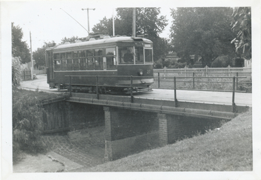
Black and White print contained within the Wal Jack Bendigo and Geelong Album, see Reg Item 5003 for more details. Photo of Bendigo Birney No. 27 crossing the bridge entering the depot 10-4-1950, Photo by Wal Jack. Printed on Ilford paper. i1 - scan of print in the album i2 - rear of image i3 - scan of negative at 3200dpi added 6/6/2020. On the rear in blue ink "SEC Bendigo Birney #27 crossing over creek near depot 10-4-50" with Wal Jack copyright stamp in the top right hand corner and the number "T210" written in.trams, tramways, bendigo, depot, birney, tram 27 -
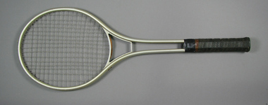
 Tennis Australia
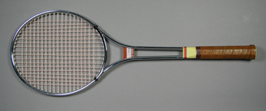
Racquet, Circa 1975
An 'R-600' metal tennis racquet with double shaft and round head and string whipping around shoulders and shaft. Metal bridge with orange adhesive label printed with 'R-600'. Cream plastic shaft casing and butt cap. Handle wrapped with perforated tan leather grip tape. Label on side of shaft states: TAIWAN. Materials: Metal, Nylon, Adhesive tape, Leather, Plastic, Stringtennis -
 Tennis Australia
Racquet, Circa 1975
A JCP 'TR-555' metal tennis racquet with double shaft and round head. Black plastic bridge with yellow adhesive label printed with 'TR/555'. Black plastic shaft casing and butt cap. Handle wrapped with perforated black leather grip tape. Adhesive label on butt cap states: JCP/ MADE IN KOREA. Materials: Metal, Nylon, Adhesive tape, Leather, Plastic, Adhesive labeltennis -
 Tennis Australia
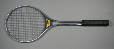
Racquet, Circa 1970
A Spalding metal tennis racquet, with double shaft, rounded head; metal throat bridges; black plastic shaft casing; and handle wrapped in black perforated leather. Black plastic butt cap has adhesive label featuring wreathed 'S' logo. Strip of brown leather used under throat as string buffer. Materials: Metal, Adhesive tape, Plastic, Leather, Adhesive label, Nylontennis -
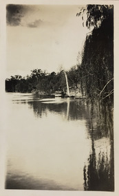 Kew Historical Society Inc
Photograph - Yarra River, Studley Park, 1924
Henry Beater Christian (1886-1962) , was a descendant of one of the earliest settler families in Kew. Employed at the Kew Asylum as a 'public servant', he was a skilled amateur photographer, photographing numerous scenes in Kew and on his travels around Victoria. The majority of his photographs date from 1916 to 1929. His finest photographs are housed in two photograph albums. Digital copy of a photograph from page 7 of the 47-page photograph album containing 261 gelatinous silver images, loaned by Diane Washfold with permission given to digitise and hold a copy in our collection. This photograph shows a covered tourist ferry moored on the river bank at Studley Park. Tourist cruises traversed the Yarra between Princess Bridge and Heidelberg, stopping at scenic points along the journey. "Studley Park / Kew"henry beater christian (1886-1962), landscape photography, kew (vic.) — yarra river, christian-washfold collection, photograph albums, kew, ferries, tourism, studley park -
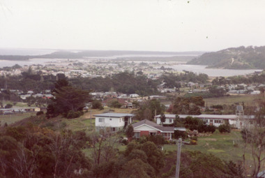 Lakes Entrance Historical Society
Photograph - Township, Fish, Marie, 1985c
\Colour photograph of township showing, North Arm and North Arm Bridge, Jemmys Point, Mount Barkly, Kalimna Heights on right, Cunninghame Arm and sand dunes on left. Looking towards Bullock Island and Rigby Island and Hopetoun Channel in centre background. Sea Vista flats in foreground. Photo take from near Telecom Tower on Merrangbaur Hill circa 1985. Lakes Entrance Victoria bridges, waterways, township -
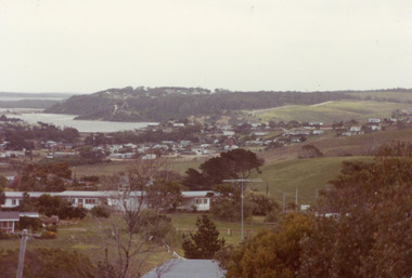 Lakes Entrance Historical Society
Photograph - Township, Fish, Marie, 1985c
Colour photograph of township showing, North Arm and North Arm Bridge, Jemmys Point, Mount Barkly, Kalimna Heights on right, Cunninghame Arm and sand dunes on left. Looking towards Bullock Island and Rigby Island and Hopetoun Channel in centre background. Sea Vista flats in foreground. Photo take from near Telecom Tower on Merrangbaur Hill circa 1985. Lakes Entrance Victoria bridges, waterways, township -
 Melbourne Tram Museum
Document - Research Notes, H. S. McComb, details of the Hawthorn system - part 3, 1950's
Set of papers - 12 foolscap - hand written in plain and red pencil giving details of the Hawthorn system, sketches showing changes to the trackwork, duplication dates, lengths of track, level book references, calculations, references to MMTB Annual reports, Bridge Road interchange with the cable trams, Items 2037 to 2041 within box 72.3 in a brown folder marked "Hawthorn Tramway Trust" in red pencil.trams, tramways, htt, hawthorn, reports, routes, track, hawthorn depot, opening, cable trams -
 Melbourne Tram Museum
Magazine, Victorian Railways, "Alterations at Epsom Road Newmarket", Jun. 1930
Photocopy of pages 361 and 365 Victorian Railways Magazine, July 1925 and page 485 of September 1925 about the construction of the rail over road/tram bridge in Epsom Road, Newmarket to replace the level crossing. Titled: "Alterations at Epsom Road Newmarket" and "Lifting 28-ton Girders an all-night job!" Gives details and photographs of the work and how financed. Sheets have been stapled together.trams, tramways, victorian railways, epsom road, level crossings, newmarket -
 Flagstaff Hill Maritime Museum and Village
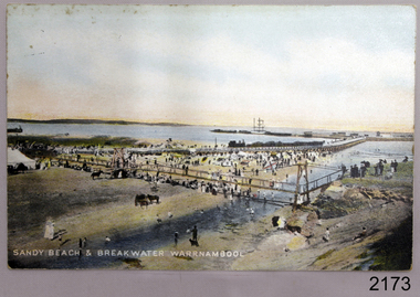
Postcard - Coastal Scene, Joseph Jordan, Sandy beach & breakwater Warrnambool, 1910
The coloured postcard depicts the Port of Warrnambool in the early 1900s. It shows the Breakwater, completed in 1890, the Viaduct, and the Merri River footbridge. There are many people on the sandy river banks, beach and bridge, and some are on the rocks of Middle Island. The printed postcard was made in England and is one of the Jordan Series produced by Joseph Jordan, a renowned photographer in Victoria's Western District.The postcard is locally significant as a record of the early footbridge over the Merri River, and the Viaduct before the space between the pylons was filled it. It shows the use of horses as a means of transportation. The photograph is also associated with Joseph Jordan, a renowned Victoria's Western District photographer.Postcard, coloured, showing the Port of Warrnambool. People are gathered on the sandy beach beside the river and near the river mouth. They are on and below the footbridge, along with several horses. Some are on the rocky Middle Island. There is a white ship in port. There is a jetty on the left, and buildings at the start of the breakwater. An inscription is printed at the bottom of the picture. The picture is one of the Jordan Series. It was printed in England in 1910."SANDY BEACH & BREAKWATER AT WARRNAMBOOL" "JORDAN SERIES" "PRINTED IN ENGLAND" "1910"warrnambool, shipwreck coast, flagstaff hill, flagstaff hill maritime museum, flagstaff hill maritime village, postcard, merri river, footbridge, warrnambool breakwater, breakwater, viaduct, middle island, port of warrnambool, jordan series, printed in england, 1910, joseph jordan, jordan photography -
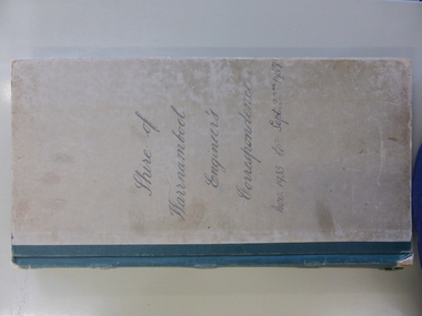 Warrnambool and District Historical Society Inc.
Legal record - Ledger, Shire of Warrnambool Engineer's Correspondence, Circa 1935
This ledger contains outward correspondence from the Shire of Warrnambool, Engineer from the period November 1935 to September 1937. It covers matters such as bridges, roads noxious weeds, drainage. It contains areas such as Wangoom Nirranda, Childers Cove, Hopkins Falls, Panmure and local names such as Jenkins, Holloway, Delaney, Davidson, Digby, Bennett, Kruger, McDowall. This collection of letters provides a very good overview of issues and work covered in the period 1935-1937.Grey card cover with dark green binding. Alphabetical index at the front . Following pages are light pink paper and numbered 1-500, two to a page. Label inside front cover Arnall & Jackson, printers lithographers, bookbinders, publishers, Manufacturing Stationers, 428 Collins St Melbourne. Repeat Order No B 87970 ledger engineer's correspondence, 1935 -1937, shire of warrnambool, warrnambool -
 Warrnambool and District Historical Society Inc.
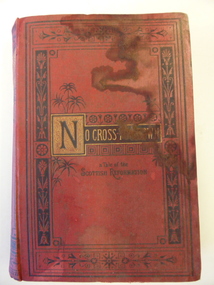
Book, No cross no crown
This book has been given by the Woodford Sunday School to Edith Cassady (note the misspelling of ‘Cassady’). Edith Cassady was the daughter of William and Elizabeth who lived at Boughton on the Merri River (near Cassady’s Bridge, Caramut Road today). This property was established about 1845. The donor of the book was William Wines, a member of a pioneering family in the Woodford district. This book is of some interest as it belonged to Edith Cassady, a member of a pioneering family who lived at Boughton on the Merri River. This is a hard cover book of 344 pages. The cover is red with black border decorations and black and gold lettering. There are several full page black and white illustrations scattered throughout the book which has 23 chapters of story. The cover and pages are much water-stained. The inscription is handwritten in black ink. ‘Woodford Sunday School Presented to Edith Cassidy (sic) by her well-wisher William Wines’ william wines, woodford, history of woodford, edith cassady, boughton property, cassady family -
 Eltham District Historical Society Inc
Photograph, Jim Connor, Main Road, Eltham, 14 Jan 2017
Eltham Gateway, Unit complex at 72-74 Bridge Street, Eltham at corner of Main Road. Before reconstruction of Main Road, this intersection had deep cutting embankments on all four corners. Roadworks and private development have levelled the land on the low side of the road. The Eltham War Memorial was originally located on the north western corner.Tomorrow's history documented todayeltham, jim connor collection, main road, eltham gateway, bridge street -
 Eltham District Historical Society Inc
Slide, Construction of Eltham Town Park, 22 Feb 1974
Construction of Eltham Town Park, later renamed Alistair Knox Park. View looking across the front of Shillinglaw Cottage and what was to be developed as the Eltham Town Common (now the site of the Eltham Library) across to the Eltham Town Park development. To the right is the Eltham Trestle Bridge and to the left what was once the overflow site for the Susan Street Tip.35 mm colour positive transparency Mount - Agfacolor Service (Blue)alistair knox park, eltham town park, eltham tip, eltham town common, eltham trestle bridge -
 Halls Gap & Grampians Historical Society
Photograph, C 1930s
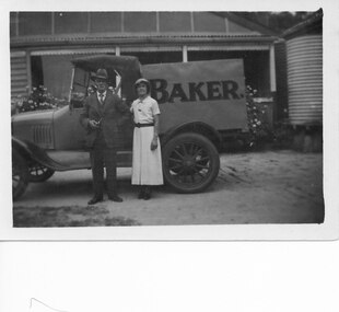
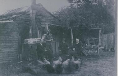
Wilfred (Fred) Warren and niece Ida Warren (who later married Robert Greer). They are shown standing in front of Warren's Bakery van, which is parked in front of their house. Warren bakery was started in 1929 by John Warren, his wife Florence, their daughter Ida and an aunt Miss Vine. see Bridging the Gap p.58A man and a woman standing in front of a truck marked "Baker.". There is a house in the background.people, warren, transport, trucks -
 Halls Gap & Grampians Historical Society
Photograph - B/W
Fred Paasch was born in Denmark in 1862. It is unknown when he arrived in Australia or when he settled in Halls Gap. He owned land generally in the area now occupied by the Halls Gap Supermarket where he established an orchard. See " Bridging the Gap " p.58-60 "Victoria's Wonderland" p.98-99.Shingle and slab house, chimney has loose brick base and tin flue. Four men in foreground. Freddy Paasch, owner of the house is seated in the centre. A number of hens feed in the near foreground. A climbing rose coyers the fence and part of the house roof.buildings, houses, people, paasch -
 Warrnambool and District Historical Society Inc.
Book, Barnes Notes on the Four Gospels, 1857
This is a book given in 1860 to Miss M. Davidson by L.H.R Miss M. Davidson would most likely be Margaret Milne Davidson (1839-1928) who was born in Kirremuir, Scotland and was the daughter of James and Isabella Davidson of Woodend near Cassadys Bridge on the outskirts of Warrnambool. She never married. The identity of ‘L. H. R.’ is unknown. This book is significant firstly because of its antiquarian interest (an 1857 publication) and secondly because of its connection to Margaret Davidson. Her father and uncle and their families were pioneer settlers in Warrnambool and thus of great importance in our history. This is a hard cover book of 53 pages. The cover is brown with an ornamental pattern impressed into the front cover and gold lettering on the spine. The book has a Preface, an Introduction, 21 chapters of text by Rev. Albert Barnes and an Index. It has a colour fold-up map of Palestine. There is a stamp of the Warrnambool & District Historical Society on the first page and an inscription in black ink. The cover is partly broken away and torn. ‘Miss M. Davidson from L.H.R. Warrnambool 4 May 1860’. margaret davidson, history of warrnambool -
 Hume City Civic Collection
Photograph, 1990-1999
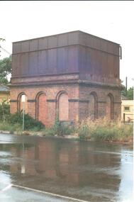
The photograph is one of a series of 6 which feature the Sunbury Railway Station complex. The complex includes photographs of the railway station with the wooden pedestrian bridge which has been demolished and two photographs of the water towers. The photographs were taken before the railway land on the west side of the line was developed to make way for a supermarket complex in 2000.A view of the brick and iron water tower which is sited on the Bendigo side of the Sunbury Railway Station. The brick structure at the base has 3 arched recesses across the front and two at the side. Two of the railway buildings are visible on either side of the tower.sunbury railway station, water towers, footbridges, bridges, railways, george evans collection -
 Melbourne Tram Museum
slide - Colour - Melbourne trams - Collins St, David Verrier, 7-11-2002
1 - C1 3032 at Collins and King St. Note the Collins St over bridge and the tram stops at King St intersection. 2 - City Circle car 925 at corner of Spencer and Collins Sts 3 - C1 3024 westbound at corner of King and Collins St. 4 - W7 1021 (Route 12) in Collins StYields information about Collins Street services and the City Circle tram.Set of four colour Sides - white Kodak KodachromeSlide marked with date and details.tramways, trams, tram 3032, king street, spencer street, c1 class, tram 3024, tram 1021, route 12, tram 925, city circle, collins st -
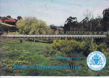 Greensborough Historical Society
Booklet, The Shire of Diamond Valley Handbook 1982, 1982_
Guide to services provided by Shire of Diamond Valley. The Shire of Diamond Valley was a Local Government Area located about 20 kilometres northeast of Melbourne. The shire covered an area of 74.38 square kilometres and existed from 1964 until 1994. Cover illustration of aqueduct and bridge over Plenty River near Apollo Parkways estste.Annual guide to services in Shire of Diamond Valley32 pages, col illus., maps. 2 copiesshire of diamond valley, greensborough, handbooks -
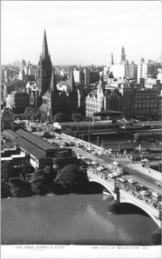 Melbourne Tram Museum
Postcard, Rose Stereograph Co, "The City of Melbourne", early 1950s
Rose Series postcard No. P 14227 titled "The City of Melbourne", with Flinders St and Princes Bridge station buildings, St Paul's Cathedral, Gas and Fuel and Ball and Welch buildings in the view. There are some 10 trams in the view. There is a Craven A cigarette advert on the south end of the station buildings. See also item 8058 for a similar photo.Yields information about Flinders Street Railways Station and the Melbourne skyline, late 1950s.Postcard - printed real photograph with Rose Stereograph Co. name on the rear.trams, st kilda road, swanston st, flinders st station, princes bridge station, tramways, princes bridge, w2 class -
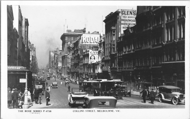 Melbourne Tram Museum
Postcard, Rose Stereograph Co, "Collins Street Melbourne", c1928
Rose Series postcard No. P 4738, titled "Collins Street Melbourne", looking west from Swanston Street. Has several cable trams in the view, the nearest one having a destination of "Victoria Bridge". There are adverts for Kodak, and "Listen in Radios". A "Tramway Inspector?" is standing in the safety zone. The Collins Street cable trams were closed in 1929.Yields information about Collins St c1928Postcard - printed real photograph with Rose Stereograph Co. name on the rear.Has the Ken Magor stamp on the rear.trams, tramways, cable trams, collins st -
 Melbourne Tram Museum
Photograph - Batman Ave tram terminus, David Menzies, 21-11-1971
The photograph shows the scissors cross over and signage at the Batman Ave tram terminus - Princes Bridge. Has two W2 class trams at the terminus, with Flinders St station in the background. This terminus was relocated as part of the Federation Square and Tennis Centre developments during 1999 - see reference. Photo by David Menzies, 21/11/1971.Provides information about the Batman Ave tram terminus.Black and white photograph with notes on rear.trams, tramways, mmtb, batman ave, w2 class, flinders st station -
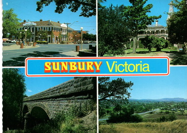 Sunbury Family History and Heritage Society Inc.
Postcard, Newcolourvue Productions Pty.Ltd, Sunbury Victoria, c1970s
The four photographs on the post card are well-known places in the town. They are the 1930s Royal Hotel building which was build on the same site of the original building on the corner of Evans and Brook Streets, Rupertswood Mansion, built 1874-45, the historic bluestone road bridge over Jacksons Creek and a view of the township in the 1970s taken from Francis Boulevard.The four views of Sunbury give an overview of the township in the 1970s before the increased development took place from the 1980s onwards.A coloured collection of four non-digital photographs of places in Sunbury in post card format. The edges of the post card are rippled. the back of the card gives details of the places as well as the maker.Sunbury Victoriaroyal hotel, rupertswood mansion, bluestone road bridge, sunbury, post cards -
 Melbourne Tram Museum
Drawing - Swanston St underground tramway at Flinders St, Melbourne & Metropolitan Tramways Board (MMTB), mid 1960s
Drawing shows the proposed layout of the Swanston St underground tram line at Flinders St. Shows the tram stop, the layout of the access to the stop, Flinders St and Princes Bridge stations, the demolition of Young and Jacksons Hotel, a railway booking office. This was part of a project that was for undergrounding of a number of tram lines in Melbourne during the early to mid 1960s. Yields information about the proposed undergrounding of the Swanston St tram line at Flinders St.Foolscap photocopied sheet on heat sensitive paper with four punched holes on the side.tramways, underground tramways, swanston st, proposed works, flinders st station -
 Eltham District Historical Society Inc
Document - Folder, Shanhun, Cheon and James
Cheon Shanhun lived between Wattle Glen and Hurstbridge from about 1870 to 1900. His son James settled in Panton Hill. Contents Letter Alison Connett, 27 December 1993, seeking information on the naming of Shanhuns Road, Cottles Bridge. Photocopy of photograph, group of people c1929, Mrs Jim Shanhun identified.Newspaper clippings, A4 photocopies, etccheong shanhun, james shanhun, shanhuns road cottles bridge, panton hill -
 Lakes Entrance Historical Society
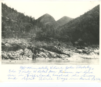
Photograph - Snowy River Buchan, 1977 c
Polish scientist explorer Dr. Lhotsky explored the Australian Alps south of Mt Kosciusko (not named at that date)as far as McKillops Bridge (unnamed then) between 1834 and 1839. His claims were largely ignored he being labelled imposter and humbug but recent research indicates his rightful place amongst Victorias early explorersBlack and white photograph of Snowy River at Suggan Buggan VictoriaApproximately where John Lhotsky the first white man known to have been in Gippsland reached the Snowy and spent three days in March 1834topography, rivers -
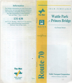 Melbourne Tram Museum
Ephemera - Timetable - route 70 - Wattle Park - Princes Bridge, The Met, 2/1998
Timetable - route 70 - Wattle Park - Princes Bridge, dated 22/2/1998, published by The Met, with Yarra Trams logo as well, and PTC name on the rear cover. Has a map of the route, forward by Geoff Lockwood Operations Supt of Camberwell depot, the Met Fare system, an advert for tram hire, timing points, and contact information.Demonstrates a timetable at the time of the formation of Yarra Trams when it was operated by The Met and the PTC.Timetable - printed, centre stapled, 24 pages.tramways, timetables, route 70, wattle park, the met, yarra trams -
 Eltham District Historical Society Inc
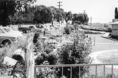
Photograph, Eltham War Memorial Gardens, Main Road, Eltham, c.September 1966, 1966c
Black and white photographic printIlford paper stamped 8963 Originally located in a Filmpro King Size Prints processing envelope $3.01 Shire of Eltham 9/9/66 and noted as Calrossie Ave area and crossed out Eltham-Yarra Glen Road, Bridge Street to Elsa Court existing conditions mid 19671966-09, eltham, eltham war memorial, main road, shillinglaw trees, war memorial buidings, war memorial garden