Showing 10927 items
matching a lake
-
 Ballarat Tramway Museum
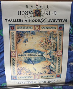
Poster, City of Ballarat Begonia Festival Committee, Begonia Festival program, 1998
Poster - full colour printed on gloss paper, advertising the 1998 Begonia Festival March 6 - 15, 1998. Has the theme "Come back to Ballarat." with a montage view of the Lake, Town Hall and Eureka banners.trams, tramways, begonia festival, city of ballarat, posters -
 Ballarat Tramway Museum
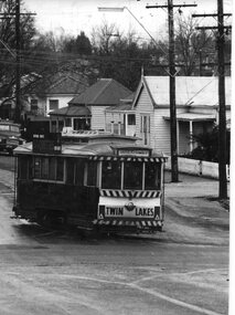
Photograph - Black & White Photograph/s, Peter Bruce, c1970
Black and white photograph of SEC No. 11 turning from Barkly St into Main St.. Tram has destination of "Gardens via Drummond Nth", Twin Lakes sign on end and SEC briquettes roof ad.trams, tramways, ballarat, barkly st., mt pleasant , tram 11 -
 Ballarat Tramway Museum
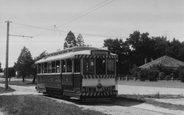
Photograph - Digital image, c1971
Yields information about Ballarat streetscape and its trams in the closing days of the SEC tramway system.Digital image from a black and white print of tram 33 outbound in Albert St Sebastopol, south of Ophir St nearing the terminus. The tram has a Twin Lakes sign on it. Photo by Marc Dahlstrom c1971. On rear is the Marc Dahlstrom stamp.trams, tramways, albert st, sebastopol, tram 33 -
 Ballarat Tramway Museum
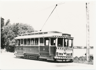
Photograph - Black & White Photograph/s, Lloyd Rogers, early 1960's
Yields information about the appearance of tram No. 12 in Wendouree Parade, St Aidans drive area, early 1960's.Black and white photograph of Ballarat tram No. 12 in Wendouree Parade, near St Aidans Drive, early 1960's. Tram has the destination of Victoria St. In the background is Lake Wendouree. Photo by Lloyd Rogers.trams, tramways, wendouree parade, st aidans drive, lake wendouree, tram 12 -
 Lakes Entrance Regional Historical Society (operating as Lakes Entrance History Centre & Museum)
Photograph, Lakes Post Newspaper, 2000
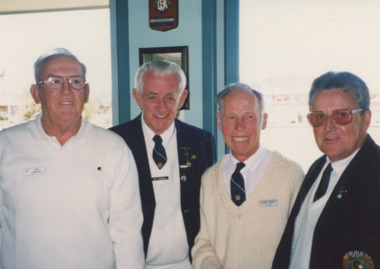
number in album 03569.03Colour photograph East Gippsland Bowls Association opening, Andy Campbell from Bairnsdale, Ian Tremmell from Lindenow, Kevin Every from Metung, John Lewis from Metung. Lakes Entrance Victoriabowls club, sports -
 Lakes Entrance Regional Historical Society (operating as Lakes Entrance History Centre & Museum)
Photograph, 1938
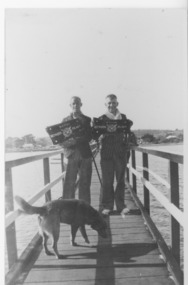
Sepia toned photograph of Jack Harbeck and Tommy Todd with dog members of Surf Life Saving Club standing on Cunningham Arm foot bridge holding patrol signs Lakes Entrance Victoria Circa 1938surf lifesaving, volunteering -
 Melbourne Legacy
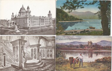
Postcard, Postcards of Ireland and Northern Ireland
Postcards were a common form of souvenirs for soldiers who were travelling around Europe either during World War 1 or just after, before returning to Australia. These were with other World War 1 memorabilia that has come from Private John Basil McLean, 2nd Reinforcements, 37th Battalion, A.I.F. There was a large collection of postcards so he may have been collecting them as souvenirs. He also had a vesta (match) case from Belfast, so it is likely he visited there. These scenes include the Guiness Brewery in Dublin and the Belfast Town Hall, and a set of scenes from Killarney. J.B. McLean (Service No. 13824) was from near Maffra, Victoria and enlisted on 22 January 1916. He embarked on 16 December 1916 for Europe. His full war record is available from AWM. He spent time with the Australian Field Artillery (Pack Section). At the end of the war he worked for a year at the A.I.F. Headquarters in London before returning to Australia on the 'Ceramic', arriving Portsea in 1920.Postcards were a very common form of communication in the first World War. Postcards as souvenirs or as correspondence would have been familiar to the first Legatees as they had served in World War 1.Postcards x 15 with images from Ireland and Northern Ireland. Most from 'Valentine's Series' printed in Scotland.01136.1 City Hall, Belfast 01136.2 Marble Stairway, City Hall, Belfast 01136.3 Killarney 01136.4 'Tis said that passing angles paused a while / To rest within and bless the Emerald Isle 01136.5 Guiness's Brewery, Lower Level, Dublin 01136.6 Scald Bank (Unloading empty casks) Guiness's Brewery, Dublin 01136.7 Fermenting House (Exterior) Guiness's Brewery, Dublin 01136.8 The Islands, Upper Lake, Killarney 01136.9 On Middle Lake, Killarney 01136.10 Serpent Lake, Gap of Dunloe, Killarney 01136.11 Shooting the rapids, Killarney 01136.12 Ross Castle, Killarney 01136.13 Eagle's Nest, Killarney 01136.14 Colleen Bawn Rock, Killarney 01136.15 Grafton Street, Dublin Each one has the word POST CARD on the reverse with room for an address and an area for Correspondence. Different makers.souvenir, world war one -
 Flagstaff Hill Maritime Museum and Village
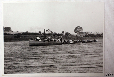
Photograph - Vessel - steam launch, Mrs. A. Dawson, Lady Loch, Feb 1907 - Jun 1910
The photograph shows the steam launch Lady Loch towing five rowing boats full of passengers on the Hopkins River at Warrnambool. The boat is travelling downstream from the riverbank near Jubilee Park towards Warrnambool and the river mouth. A similar trip in 1909 was a fund-raising excursion when the Lady Loch was to tow boats from Flett & Sons' boating establishment on the Hopkins River, travelling towards Jubilee Park. The photograph was taken between February 1907 and June 1910 by Mrs A. G. Dawson from the Hopkins River Bank at “Allandale”, which she was leasing. She took another photograph that day, which was published in the Warrnambool Standard on 24th March 1973. At the time of the photograph the launch Lady Loch was owned by James Flett & Son who operated a boatshed on the bend of the Hopkins River. The boat was described as “a fine little steamer”. In 1916 it was licenced to carry 42 passengers. The LADY LOCH: - In February 1884 Mr Sutton’s steam launch had the name of Lady of the Lake. The boat was part of the entertainment for a Sunday school picnic at Ballarat Lake and Gardens. In October 1884 Mr Ivey from Lake Wendouree purchased two vessels, the steamer Ballarat and Mr Sutton’s well-known and popular launch, Lady of the Lake, to join his own fleet of pleasure boats. In November 1887 Mr Mark Hooper’s purchase of a ‘new’ pleasure boat, Lady of the Lake, arrived in Colac to be an addition to his boating business. The launch had been transported by road from Ballarat, but the boiler and the engine had travelled by rail the previous day. In June 1888, Fanny Nelson purchased the steam launch Lady of the Lake for her Nelson’s Boating and Fishing Establishment on the Hopkins River, Warrnambool. She renamed it Lady Loch. People have suggested the mane was in honour of the wife of the then-current Governor of Victoria, Sir Henry Loch, and the local paper stated that Lady Loch flew the Governor’s colours of yellow, black and blue on her first trip under Nelson’s ownership, Sunday 12th August 1888. In 1890 Fanny Nelson sold her complete business, including Lady Loch, to Mr Chapman. in January 1897 James Flett & Sons, already involved in boating, purchased the business from Chapman. In January 1916, Flett advertised everything for sale, including the boatshed and the steam launch Lady Loch. NOTE: - at least three vessels in Victoria were named Lady Loch; a river launch (ca 1884-ca 1916), a steamer ferry (1884-1920s) and a government steam lighthouse tender HMS Lady Loch (1886-1962)The photograph of the Lady Loch pleasure steamer represents the social and recreational activities of late 19th-century people from Warrnambool and the local district. It shows an example of the pleasure craft of that era. The history of the Lady Loch includes the history of fishing and boat hire businesses of that period. The photograph is also connected with an early Warrnambool buat builder James Flett & Sons. representing the maritime history of the town.Photograph, black and white, of the steam launch Lady Loch towing five rowing boats downstream on the Hopkins River from Jubilee Park towards the river mouth. There are many figures on the boats. The photograph was taken from a property called Allandale on the south river bank between February 1907 and June 1910. The photographer was Mrs A. G. Dawson. The Lady Loch was owned by Mr James Flett & Sons at that time. The photograph is mounted on card.flagstaff hill, warrnambool, shipwrecked-coast, flagstaff-hill, flagstaff-hill-maritime-museum, maritime-museum, shipwreck-coast, flagstaff-hill-maritime-village, lady of the lake, lady of the lake steamer, lady loch steamer, lake colac steamer, hopkins river warrnambool, jubilee park warrnambool, francis maria mann, andrew abernathy nelson iiird, hopkins hotel, nelson's boathouse, chapman's boathouse, flett's boathouse, fanny (francis) nelson, james flett & sons -
 Warrnambool and District Historical Society Inc.
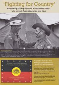
Booklet, 'Fighting for Country' Honouring Aborigines from South West Victoria who served Australia during war time, February 2014
This booklet was collated and printed for the 2014 Lake Bolac Eel Festival, ‘Return to Country’. The author, Peter Bakker, has spent several years researching the part played by south western Victorian aborigines and this booklet details the results of this research. Several of the soldiers came from the Warrnambool area.This is a booklet of ten pages with printed material and black and white and colour photographs and a map.Front Cover: ‘Fighting For Country – Honouring Aborigines from South West Victoria who served Australia during War Time’ (plus other printed material) Back Cover: Map and List of Service Men and Women of Aboriginal Descent with connections to South West Victoria aborigines from south west victoria, return to country, lake bolac eel festival, peter bakker, world war one, world war two, korean war, vietnam war -
 Lakes Entrance Regional Historical Society (operating as Lakes Entrance History Centre & Museum)
Photograph, 1994 c
Also two photographs of U3A Geology group on track overlooking Mitchell River 04609.1 and .2 10 x 15 cm and black and white photograph of Billy Goat Bend donated by Lakes Post Newspaper 6 January 2010 04609.3 11.5 x 8.5 cmColour photograph of Mitchell River from Billy Goat Bend showing steep gorge between heavily forested high banks. Glenaladale Victoriajetties, topography, waterways -
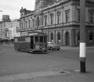 Ballarat Tramway Museum
Photograph - Digital Image, Peter Knife, SEC 28 Westbound in Sturt St, 14/8/1965
Digital image of SEC 28 Westbound in Sturt St at Armstrong St with the Ballarat Town Hall in the background. The tram has a Castrol oil and SEC cooking roof advert. On the front are a Twin Lakes and dancing at Civic Hall signs. Photo by Peter Knife 14 Aug 1965,Yields information about Ballarat's trams in August 1965.Digital image of a black and white negativetramways, tramcars, ballarat, sturt st, town hall, tram 28 -
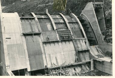 Kiewa Valley Historical Society
Photo - Junction Dam Construction, Circa 1940's
Junction (Lake Guy) Dam is a 'slab and buttress' type wall. A timber frame is built and then filled with concrete. The first batch of concrete was placed in September, 1940. By June, 1941 the buttresses were finished to a height safe from floods and in October of that year a flood of 2,800 cusecs occurred but with only slight damage to the installations. Industrial trouble caused some delays but there was also slow progress on the part of the contractor and the work was taken over by the S.E.C., terminating the contract. The dam was completed in March, 1944. A walkway was made through the dam wall. Lake Guy was named after Mr. L.T. Guy who was the Resident engineer, in charge of construction work and associated activities on the Kiewa Area from 1939 to November 1946Photos of the construction of the Junction Dam detail the harsh conditions faced by construction workers, building dams and villages to accommodate workers in the 1940s to the 1950s. Australia at this period in time, experienced a surge of population (influx of World War II refugees), which was the catalyst for developing and undergoing an enormous hydroelectricity program for the Alpine regions, both in Victoria and New South Wales. This program was initiated to supply electricity to the major southern Australian cities of Adelaide, Melbourne and Sydney. It was thought that these developments would reduce, if not eliminate, the requirement for coal driven power stations. However time has demonstrated that these power stations have not matched the demand required by the industries and the populations of the major urban and cities.Black and white photograph of Junction Dam constructionjunction dam, bogong, secv -
 Kiewa Valley Historical Society
Photo - Junction Dam Diversion Tunnel
Junction (Lake Guy) Dam is a 'slab and buttress' type wall. A timber frame is built and then filled with concrete. The first batch of concrete was placed in September, 1940. By June, 1941 the buttresses were finished to a height safe from floods and in October of that year a flood of 2,800 cusecs occurred but with only slight damage to the installations. Industrial trouble caused some delays but there was also slow progress on the part of the contractor and the work was taken over by the S.E.C., terminating the contract. The dam was completed in March, 1944. A walkway was made through the dam wall. Lake Guy was named after Mr. L.T. Guy who was the Resident engineer, in charge of construction work and associated activities on the Kiewa Area from 1939 to November 1946.Diversion dams are installed to raise the water level of a body of water to be redirected. The redirected water is used for hydro electric power generation. A diversion tunnel is usually bored through solid rock next to the dam site to bypass the dam construction site. The dam is built while the river flows through the diversion tunnel.Photos of the construction of the Junction Dam detail the harsh conditions faced by construction workers, building dams and villages to accommodate workers in the 1940s to the 1950s. Australia at this period in time, experienced a surge of population (influx of World War II refugees), which was the catalyst for developing and undergoing an enormous hydroelectricity program for the Alpine regions, both in Victoria and New South Wales. This program was initiated to supply electricity to the major southern Australian cities of Adelaide, Melbourne and Sydney. It was thought that these developments would reduce, if not eliminate, the requirement for coal driven power stations. However time has demonstrated that these power stations have not matched the demand required by the industries and the populations of the major urban and cities.Black and white photograph of Junction Dam diversion tunnel at Bogong VillageHandwritten on back - Junction Dam Diversional Tunnelbogong, secv, junction dam, lake guy -
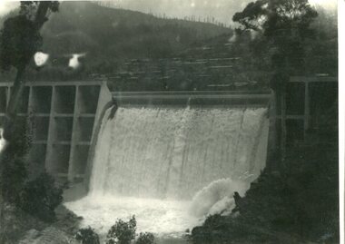 Kiewa Valley Historical Society
Photograph - Junction Dam spilling
Junction (Lake Guy) Dam is a 'slab and buttress' type wall. A timber frame is built and then filled with concrete. The first batch of concrete was placed in September, 1940. By June, 1941 the buttresses were finished to a height safe from floods and in October of that year a flood of 2,800 cusecs occurred but with only slight damage to the installations. Industrial trouble caused some delays but there was also slow progress on the part of the contractor and the work was taken over by the S.E.C., terminating the contract. The dam was completed in March, 1944. A walkway was made through the dam wall. Lake Guy was named after Mr. L.T. Guy who was the Resident engineer, in charge of construction work and associated activities on the Kiewa Area from 1939 to November 1946Photos of the construction of the Junction Dam detail the harsh conditions faced by construction workers, building dams and villages to accommodate workers in the 1940s to the 1950s. Australia at this period in time, experienced a surge of population (influx of World War II refugees), which was the catalyst for developing and undergoing an enormous hydroelectricity program for the Alpine regions, both in Victoria and New South Wales. This program was initiated to supply electricity to the major southern Australian cities of Adelaide, Melbourne and Sydney. It was thought that these developments would reduce, if not eliminate, the requirement for coal driven power stations. However time has demonstrated that these power stations have not matched the demand required by the industries and the populations of the major urban and cities.Black and white photograph of Junction Dam spilling at Bogong VillageHandwritten in pencil - Junction Dam spillingbogong, junction dam, lake guy, secv -
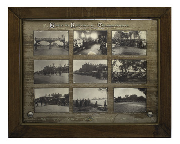 Arapiles Historical Society
Photograph - Black and white photographs, framed, Back to Natimuk Celebrations, 1924
The photographs depict the "Back to Natimuk Celebrations" organised between 28 February and 4 March 1924 in Natimuk. From top to bottom, left to right: - Welcome sign in the main road. - Locals in the school titled "Back to school" - "Group of comebacks at lake" (Natimuk) - Band procession on main road - Start of motor ? - Swimming carnival at Natimuk lake - Evolution of farm implements - Group taken on the site of Mrs Scudasore's old home: Mr A.W. Lockwood (secretary), Mrs Scudasore (first white woman resident in district), Mr G. Graham (president), Mrs J. Russell (first white child born in district-daughter of Mrs Scudasore), Mr John Russell. - Group of cars at Mount Arapiles. Significant as it depicts first settlers.9 black and white photographs set in inscribed board and wooden frameBack to Natimuk Celebrations. Feb 28th to March 4th 1924natimuk, festivities, mount arapiles, lake natimuk, a.w. lockwood, mrs scudasore, g.t. graham, john russell, mrs john russell, swimming carnival -
Stawell Historical Society Inc
Photograph, Aerial Photos of Stawell from a Hot Air Balloon 1992 -- 12 Photos
Series of 12 Aerial Photos of Stawell. Hot Air Balloon 1992 1. Cnr Maude St & Grant Street 2. Maude St Napier Street & Railway cutting 3. Trotting Track 4. Roundabout Wimmera & Sloane Street 5. Florence Street towards Cato Lake & Park 6. Grampians Range with Lake Lonsdale near center 7. Gold Reef Mall looking West 8. Church Street looking West 9. Looking towards Black Range 10. Moonie Dams Darlington Road Leisure Complex 11. Stawell Gold Mine Evaporations Dams, Stawell Water Reservoirs, Moonie Dams 12. Darlington Road looking towards Black RangeColour photographs from Airstawell -
 Ballarat Tramway Museum
Slide - 35mm slide/s - set of 2, Noel Simons, 23/12/1967 12:00:00 AM
Set of two Kodak Ready-mount with slides made from the Association of Railway Enthusiast Provincial Tramways film strip. Both taken by D. Macartney, 23/12/1967. See Reg Item 2560 for details of the slide strip and reference to the other slides within the strip. 1164.1 - No. 18 north bound in Drummond St. North, at Victoria Ave. - side on photo - slide has a red coloured background. 1164.2 - No. 32 decorated for Myer's Christmas tram at Macarthur St. with destination of "Victoria St." See Reg Item 4184 for a black and white photograph.1164.1 - "No. 18 heads up Drummond St. North, bound for "Gardens"" 1164.2 - "No. 32 with Christmas decoration alongside Lake Wendouree" All have date stamp of "Dec 1967" in blue ink. Writing in blue ink.tramways, trams, myer, christmas trams, drummond st. nth, wendouree parade, tram 18, tram 32 -
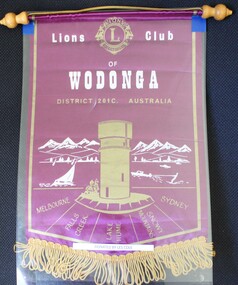 Wodonga & District Historical Society Inc
Banner - Lions Club of Wodonga, c1965
Leslie William Cole was born on 31 January 1920 in Albury, the first child of William James Cole and Gwendoline Fair. Les spent most of his childhood living with his grandparents in Bethanga, Victoria. In 1934 when he finished school, Les moved into Wodonga. His first job was at Mates Timber Yard. He later worked for Mylons of Wodonga driving taxis and buses. In 1939 after completing militia training, Les applied to enlist with the RAAF and eventually trained as an Aircraft Mechanic. He was posted to the 6th Squadron, serving in Port Moresby, Milne Bay and Goodenough Island before returning to the RAAF base in Sale, Victoria. On discharge. Les returned to Wodonga and resumed working with Mylons. After a range of jobs, Les and his wife Lorna operated a shop in Ariel Street, Wodonga. In the community, Les was a founding member of Wodonga Lions Club. He also joined the Civil Defence which was a predecessor off the SES. He became the Communications Officer and trained other members. Les became the first Controller of the Wodonga Branch of the State Emergency Service, a position he held for 17 years. The new SES headquarters was named in his honour. In retirement he also worked as a Volunteer Community Driver. Les was also named Wodonga Citizen of the Year in 1984 Les continued living in Wodonga until the age of 103 in 2023, when he moved to Melbourne to be closer to his children. He passed away on 12 December 2023. The Lions Club of Wodonga was chartered in 1965 with 18 Founding Members including Les Cole. Lions Australia was first formed in Lismore, NSW in September and has grown to be Australia’s largest service club organisation.A small purple and gold fringed banner with the emblem of Wodonga Lions ClubAt the top centre: The logo of Lions International Across the centre of banner: Lions Club of Wodonga / District 201C Australia In semi-circle below Water Tower: Melbourne/ Falls Creek/Lake Hume/ Snowy Mountains/ Sydneyles cole, wodonga lions club, lions international -
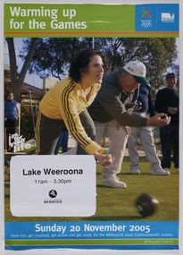 City of Greater Bendigo - Civic Collection
Poster - Advertising poster, Warming up for the Games, 2005
The 2006 Commonwealth Games, officially the XVIII Commonwealth Games and commonly known as Melbourne 2006, was an international multi-sport event for members of the Commonwealth held in Melbourne, Australia between 15 and 26 March 2006. It was the fourth time Australia had hosted the Commonwealth Games. Glossy colour poster advertising the upcoming Commonwealth Games, depicting women in foreground and man behind lawn bowling. t; Warming up for the games. ll; (Sticker) Lake Weeroona / 11.00am - 3.30pm / City of Greater Bendigo b; 20th November 2005. Have fun, get involved and get active for the Melbourne 2006 Commonwealth Games.city of greater bendigo tourism, city of greater bendigo community partnerships, commonwealth games 2006, city of greater bendigo events -
 The Beechworth Burke Museum
Photograph
The photograph depicts two young men standing atop a prominent outcrop at Lake Sambell, with buildings visible on the further shore. The present day park and reserve occupies the site of the former Rocky Mountain Mining Company, an open-cut sluice mine that began operations in the mid-Nineteenth Century and operated until the early 1900s, through the peak of Victoria’s Gold Rush. It was converted into a park and leisure area in the 1920s. Lake Sambell was formally opened to the public on Friday 5th October 1928 and was opened by the Victorian Government’s Minister of Lands, Mr Bailey, as part of initiatives to boost the economies and development of country towns. The lake was named after Mr L.H. Sambell, a shire engineer and secretary of the Forward Beechworth Committee who was involved in promoting the transformation of the mining site and promoting plantation forestry and tourism as alternative industries. £300 to begin the process was provided by Mr J. McConvill, a former resident of Beechworth, who is remembered in a street name adjacent to the lake. An article in the Ovens and Murray Advertiser on Saturday, 5th May, 1917, gives some insight into issues in the Rocky Mountain Mining Company’s final years. The writer details the 1917 annual meeting of the Rocky Mountain Mining Company, stating that locals present appeared ‘well pleased this important local industry is in such a prosperous condition and that future prospects are so encouraging’. The author describes plans to give workers a bonus as evidence of profit-sharing that would ‘bridge the gulf between capital and labour’. The article concludes, however, with the statement that ‘there is a little arithmetical puzzle in the report in connection with the dredging operations I have been unable to solve.' The photograph is significant as it contributes to knowledge about how Beechworth reinvented itself after the Gold rush period, and more broadly how country towns repurpose and redevelop infrastructure and facilities to meet the present needs of their population. Sepia rectangular photograph printed on matte photographic paper. Obverse: nil. Reverse: 3471 / Velox (paper mark)beechworth, beechworth lake, lake sambell, l.h. sambell, mcconvill, rocky mountain mining company, rocky mountain mining co, minister of lands, forward beechworth committee, wallace park-lake sambell development scheme, wallace park lake sambell development scheme, lake, sambell, j. mcconvill, recreation, reserve, park, transformation, repurposed, redeveloped -
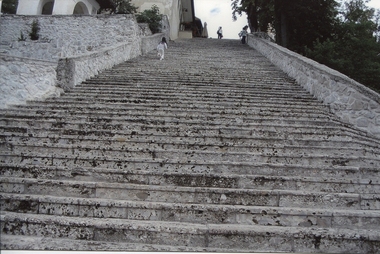 Ballarat Heritage Services
Digital photograph, Dorothy Wickham, Steps at Lake Bled, Slovenia, 2007
The lake surrounds Bled Island (Blejski otok). The island has several buildings, the main one being the pilgrimage church dedicated to the Assumption of Mary (Cerkev Marijinega vnebovzetja), built in its current form near the end of the 17th century, and decorated with remains of Gothic frescos from around 1470 in the presbyterium and rich Baroque equipment. The church has a 52 m (171 ft) tower and there is a Baroque stairway dating from 1655 with 99 stone steps leading up to the building. The church is frequently visited and weddings are held there regularly. Traditionally it is considered good luck for the groom to carry his bride up the steps on the day of their wedding before ringing the bell and making a wish inside the church. The traditional transportation to Bled Island is a wooden boat known as a pletna. The word pletna is a borrowing from Bavarian German Plätten 'flat-bottomed boat'. Some sources claim the pletna was used in Lake Bled as early as 1150 AD, but most historians date the first boats to 1590 AD. Similar in shape to Italian gondolas, a pletna seats 20 passengers. Modern boats are still made by hand and are recognizable by their colorful awnings. Pletna oarsman employ the stehrudder technique to propel and navigate boats across the lake using two oars. The role of the oarsman dates back to 1740, when Empress Maria Theresa granted 22 local families exclusive rights to ferry religious pilgrims across Lake Bled to worship on Bled Island. The profession is still restricted. Many modern oarsman descend directly from the original 22 families. https://en.wikipedia.org/wiki/Lake_BledDigital photographlake bled, church, stairway, steps, slovenia, stone, tradition -
 Bendigo Military Museum
Photograph - Group Photos - Army Headquarters Survey Regiment, Fortuna, Bendigo, c1950s to 1960s
This is a collection of three photographs taken at the Army Headquarters Survey Regiment, Fortuna Villa, Bendigo, circa 1950s to 1960s. Personnel are not unidentified.This is a collection of three group photographs taken at the Army Headquarters Survey Regiment, Fortuna Villa, Bendigo, circa 1950s to 1960s. The photographs were printed on photographic paper and are part of the Army Survey Regiment’s Collection. They were scanned at 300 dpi. .1) - Photo, black and white, 1950s. Group photo of unidentified personnel by Fortuna’s lake. .2) - Photo, black and white, 1950s. Group photo of unidentified personnel at a wind up party. .3) - Photo, black and white, 1960s. Group photo of unidentified personnel by Fortuna’s lake.Personnel are not identified. Photo .2P. is annotated ‘Wind up party’.royal australian survey corps, rasvy, army survey regiment, army svy regt, fortuna, asr -
 Ballarat Tramway Museum
Slide - 35mm slide/s - set of 2, Noel Simons, 24/11/1962 12:00:00 AM
Set of 2 Kodachrome transparencies taken on 24/11/1962. 1163.1 - No. 21 in Bridge St., with destination of "Mt Pleasant" with a Twin Lakes advert and "Trotting Showgrounds Friday Night" auxiliary board on front dash panel. Also Picot & Widmer, chemists shop alongside tram. Tram at a stop with people boarding. 1163.2 - No. 13 and 30 crossing at the end of the double track in Sturt. St, at Grenville St. Both trams have Twin Lakes signs. Photo shows buildings either side of Sturt St.1163.1 - "No. 21 in Bridge St. Ballarat" 1163.2 - "No. 13 and 30 at foot of Sturt St. Ballarat" All have date stamp of "24 Nov. 1962" in purple ink. All black ink unless otherwise noted.tramways, trams, ballarat, bridge st, grenville st., sturt st., tram 13, tram 21, tram 30 -
 Conservation Volunteers
'Conservateers' T-Shirt (1983) - do you have one?, Unknown, 'Conservateers' T-Shirt (1983), 1988
By the early 1980's, the population of Little Terns visiting Rigby Island in the Gippsland Lakes had fallen to a low level as the species has a very low reproduction rate. ACTV arranged, at short notice, a "Tern watch" which was literally volunteers babysitting the birds. The project was very successful.This was the first ACTV project which actively used volunteers to protect a threatened species. The Little Terns are now off the official list of endangered species. It was among the first of our corporate sponsorships.Cream coloured, t-shirt, with ACTV logo, blue ANZ logo and text "Tern Watch '88" on front.gippsland, anz bank, little tern, tern watch, gippsland lakes, actv, conservation volunteers, endangered species, successful species recovery -
 Lake Bolac & District Historical Society
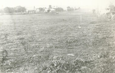
Black and white photograph, Mortlake Rd./Montgomery St., Lake Bolac, 1912
Mortlake Rd./Montgomery St., Lake Bolac, 1912. Looking northwards. Image shows the broad expanse of the grass verge and road (top left) with Josiah Park's forge and smithy, the pub and the store, with peppercorn trees planted along the street. On the right the public hall can be faintly seen.lake bolac, montgomery st., 1912. -
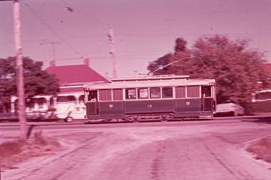
 Ballarat Tramway Museum
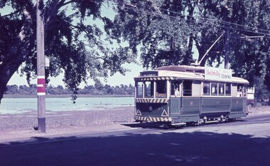
Slide - 35mm slide/s, Keith Caldwell, Tram 14 Wendouree Parade, 12/03/1962
Photo by Keith Caldwell on 12/3/1962 of tram 14 in Wendouree Parade at Depot Junction. Note the compulsory stop sign on the east side or the left hand side of the pole. The tram has the destination of Victoria St and has a Electricity Cooking roof advertisement. Lake Wendouree in the background.Yields information about the nature of tram services in Wendouree Parade.Agfa colour slide, white cardboard mount.In ink "Ballarat 12.3.62"tramways, trams, tram 14, wendouree parade, depot junction, lake wendouree -
 Bendigo Historical Society Inc.
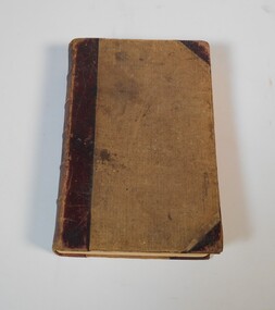
Book - Geographical dictionary
The Gazetteer presents an extensive a to z list of Victorian towns and villages, lakes, rivers and creeks, islands, bays, hills and mountains, runs and other localities and features. Entries include latitude and longitude, populations, proximity to other towns, local industries, coach and mail runs, hotels, churches and schools.Bailliere's Victorian Gazetteer and road guide containing the most recent and accurate information as to every place in the colony. Brown hardcover book, on the spine: Victorian Gazetteer with map 1865. The first and last pages are advertisements. The book has 442 pages listing every place in the colony. The map is not included. Compiled by Robert P. Whitworth. Published by Bailliere, Regent Street Unreadable name on first page and the name of F. Houston in blue pen on first page geographic dictionary, colony of victoria -
 Warrnambool and District Historical Society Inc.
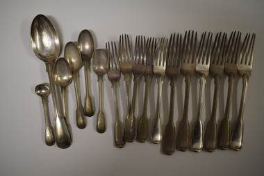
Cuttlery, George Rolfe, Mid to late 19th century
In 1854 in Melbourne George Rolfe Senior established an import business dealing in groceries, wines and spirits and tea. His son George, born in England, took over the business of Rolfe and Co in 1871. A keen sportsman, George Rolfe’s love of fishing led him to take frequent holidays in Warrnambool. He began buying blocks of land near the mouth of the Hopkins River in Warrnambool in the 1870s. By the 1880s Rolfe owned 50 acres in the Hopkins River area and named the property, Lyndoch. He built stables, chaff and bone sheds, a jetty, a boatshed, a water well, a windmill, a reservoir and extensive gardens. He also bought the nearby properties of Shipley and Fairy Hill, establishing a stud farm and breeding cattle. In 1891 he married Jane Ann Lake, the widow of his property manager, and when he died in 1919 his step-daughters, Florence and Annie Lake, inherited Lyndoch. The property was sold and became an aged care facility in 1952. The cutlery items were in use in the building erected by Florence Lake in 1920 and known today as Lyndoch but the ‘R’ monogram on the items suggest that they belonged to George Rolfe or even his father before him.These cutlery items are of considerable importance as mementoes of George Rolfe and his family. They were prominent in Warrnambool’s history in the late 19th and early 20th centuries with the establishment and development of the property, Lyndoch, near the mouth of the Hopkins River. These are 17 pieces from a silver cutlery set that belonged to the Rolfe family (one tablespoon, six large forks, five smaller forks, four small spoons and one mustard spoon.) All the pieces of cutlery have a monogrammed ‘R’ at the end of the handles. Twelve of the items are tarnished and one small spoon is very worn. All the items have six hallmarks. ‘R’george rolfe, lyndoch, warrnambool, rolfe & co. melbourne, florence lake, lyndoch warrnambool., history of warrnambool -
Glenelg Shire Council Cultural Collection
Book, People of the Lake - the story of Lake Condah Mission, n.d
27,000 years ago molten lava pouring from the eruption of Budjbim (Mt. Eccles) formed Lake Condah and the unique landscape that surrounds it. Over time this area known as "The Stony Rises" or "The Stones" became an important geological area for Koories and, later, Europeans.12 page A4 size booklet, cream with brown print.27,000 years ago molten lava pouring from the eruption of Budjbim (Mt. Eccles) formed Lake Condah and the unique landscape that surrounds it. Over time this area known as "The Stony Rises" or "The Stones" became an important geological area for Koories and, later, Europeans.aboriginal history, gunditjmara, lake condah, mission history, budj bim -
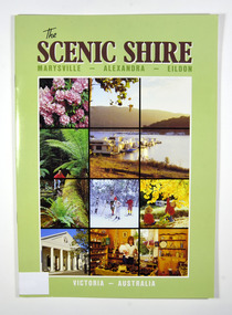 Marysville & District Historical Society
Book, The Scenic Shire-Marysville-Alexandra-Eildon, 1987
A book outlining recreational activities available in the towns of Marysville, Alexandra and Eildon and their surrounds Paperback. Front cover has a series of colour photographs depicting flora, places to visit and activities in the areas named in the title. Back cover has a photograph of houseboats at Eildon Boat Club at Anderson Harbour on Lake Eildon.Stamp of Marysville & District / Historical Society Inc / P.O. Box 22 / Marysville 3779marysville, alexandra, eildon, recreation