Showing 8870 items matching " construction"
-
 Kew Historical Society Inc
Photograph - Railway level crossing in Glenferrie Road, Glenferrie, E.J. Dower, c.1912
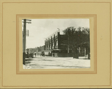
One of a series of photographs, taken by Edgar James Dower in the second decade of the twentieth century. Born and raised in Olinda, his family later moved to Surrey Hills. He worked as an adult as a clerk in the city office of the Metropolitan Gas Company, and in his role as a 'collector', he was able to photograph scenes including the construction of tramlines and associated buildings in Kew, Hawthorn, Camberwell and Surrey Hills. Later he established a real estate agency with his brother - the E.J. Dower Real Estate Agency, Dandenong Office.The image is an historically significant record of the development of transport infrastructure which was used to connect Victorians in the first two decades of the twentieth century. This development resulted from increases in population and the consequent extension of Melbourne's suburbs. The photographs, both individually and collectively, richly detail the labour of workers and the tools and machinery used to create and extend Melbourne's public transport network in the years preceding and during World War 1.Digital copy of an original mounted photograph showing Glenferrie Road Hawthorn, looking north towards the old railway level crossing that existed before the line was elevated on a bridge over Glenferrie Road. "The Don Store" at right is immediately behind the old railway level crossing. The tree and shops at left before the crossing were to be removed / demolished as part of the realignment of the train tracks.Annotated verso: "1914 [deleted]/1913 / Glenferrie Road showing railway gates / Taken just before the commencement of the regrading of railway line to Camberwell".theme --- travelling by tram, theme -- connecting victorians by transport and communications, glenferrie road -- hawthorn (vic.), railways -- hawthorn, the don store -- hawthorn (vic.) -
 Kew Historical Society Inc
Photograph - Camberwell Railway Station & Auburn Railway Station, E.J. Dower, 1915
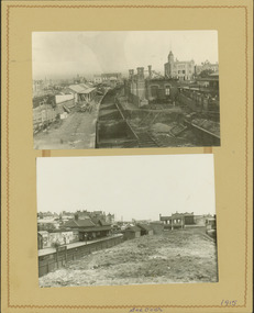
One of a series of photographs, taken by Edgar James Dower in the second decade of the twentieth century. Born and raised in Olinda, his family later moved to Surrey Hills. He worked as an adult as a clerk in the city office of the Metropolitan Gas Company, and in his role as a 'collector', he was able to photograph scenes including the construction of tramlines, railways and associated buildings in Kew, Hawthorn, Camberwell and Surrey Hills. Later he established a real estate agency with his brother - the E.J. Dower Real Estate Agency, Dandenong Office.The image is an historically significant record of the development of transport infrastructure which was used to connect Victorians in the first two decades of the twentieth century. This development resulted from increases in population and the consequent extension of Melbourne's suburbs. The photographs, both individually and collectively, richly detail the labour of workers and the tools and machinery used to create and extend Melbourne's public transport network in the years preceding and during World War 1.Digital copy of a an original mounted photograph showing the Camberwell Railway station being demolished and the Auburn Railway Station. The photos were later dated by the photographer as being taken in 1915.verso: "2015 / Top picture - Original Camberwell railway station being demolished / Bottom picture - Original Auburn Railway station on left / Taken by E.J. Dower"theme -- connecting victorians by transport and communications, camberwell railway station, auburn railway station, theme - travelling by train -
 Kew Historical Society Inc
Photograph - Construction of the electric tram line in Riversdale Road, Camberwell
One of a series of photographs, taken by Edgar James Dower in the second decade of the twentieth century. Born and raised in Olinda, his family later moved to Surrey Hills. He worked as an adult as a clerk in the city office of the Metropolitan Gas Company, and in his role as a 'collector', he was able to photograph scenes including the construction of tramlines, railways and associated buildings in Kew, Hawthorn, Camberwell and Surrey Hills. Later he established a real estate agency with his brother - the E.J. Dower Real Estate Agency, Dandenong Office.The image is an historically significant record of the development of transport infrastructure which was used to connect Victorians in the first two decades of the twentieth century. This development resulted from increases in population and the consequent extension of Melbourne's suburbs. The photographs, both individually and collectively, richly detail the labour of workers and the tools and machinery used to create and extend Melbourne's public transport network in the years preceding and during World War 1.Digital copy of an original mounted photograph showing workers excavating Riversdale Road, Camberwell, in preparation for the laying of the new electric tramline.Verso: "Riversdale Road between Wattle Valley and Highfield Roads"theme -- connecting victorians by transport and communications, riversdale road - camberwell (vic.), theme -- travelling by tram -
 Kew Historical Society Inc
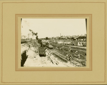
Photograph - Regrading the Camberwell Railway Line near Burke Road, E.J. Dower, 1915
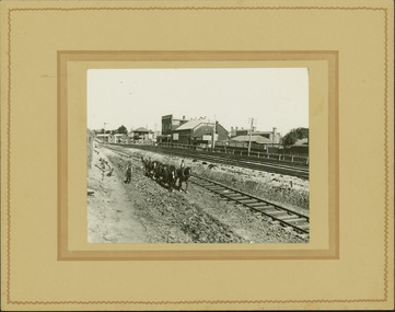
One of a series of photographs, taken by Edgar James Dower in the second decade of the twentieth century. Born and raised in Olinda, his family later moved to Surrey Hills. He worked as an adult as a clerk in the city office of the Metropolitan Gas Company, and in his role as a 'collector', he was able to photograph scenes including the construction of tramlines, railways and associated buildings in Kew, Hawthorn, Camberwell and Surrey Hills. Later he established a real estate agency with his brother - the E.J. Dower Real Estate Agency, Dandenong Office.The image is an historically significant record of the development of transport infrastructure which was used to connect Victorians in the first two decades of the twentieth century. This development resulted from increases in population and the consequent extension of Melbourne's suburbs. The photographs, both individually and collectively, richly detail the labour of workers and the tools and machinery used to create and extend Melbourne's public transport network in the years preceding and during World War 1.Digital copy of an original mounted photograph depicting workers regrading the Camberwell Railway line following the demolition of the original Camberwell Railway Station. The level crossing gates at Burke Road can be seen in the distance. Named buildings include The Assembly Hall at right.Verso: "1915 / Regrading Camberwell Railway Line / Note Railway Gates on Burke Road / Taken by E.J. Dower"theme -- connecting victorians by transport and communications, theme - camberwell railway station, theme - travelling by train -
 Kew Historical Society Inc
Photograph - Regrading the Camberwell Railway Line, E.J. Dower, 1915
One of a series of photographs, taken by Edgar James Dower in the second decade of the twentieth century. Born and raised in Olinda, his family later moved to Surrey Hills. He worked as an adult as a clerk in the city office of the Metropolitan Gas Company, and in his role as a 'collector', he was able to photograph scenes including the construction of tramlines, railways and associated buildings in Kew, Hawthorn, Camberwell and Surrey Hills. Later he established a real estate agency with his brother - the E.J. Dower Real Estate Agency, Dandenong Office.The image is an historically significant record of the development of transport infrastructure which was used to connect Victorians in the first two decades of the twentieth century. This development resulted from increases in population and the consequent extension of Melbourne's suburbs. The photographs, both individually and collectively, richly detail the labour of workers and the tools and machinery used to create and extend Melbourne's public transport network in the years preceding and during World War 1.Digital copy of an original mounted photograph depicting workers regrading the Camberwell Railway line following the demolition of the original Camberwell Railway Station. The photographer noted the presence of a wheeled 'steam shovel' at left Verso: "1915 / Regrading Camberwell railway line taken just east of Camberwell Station / Note steam shovel at work / Taken by E.J.D."theme -- connecting victorians by transport and communications, theme - camberwell railway station, theme - travelling by train -
 Kew Historical Society Inc
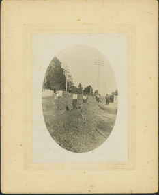
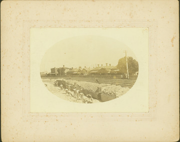
Photograph - Regrading the Camberwell Railway Line near Burke Road, E.J. Dower, 1915
One of a series of photographs, taken by Edgar James Dower in the second decade of the twentieth century. Born and raised in Olinda, his family later moved to Surrey Hills. He worked as an adult as a clerk in the city office of the Metropolitan Gas Company, and in his role as a 'collector', he was able to photograph scenes including the construction of tramlines, railways and associated buildings in Kew, Hawthorn, Camberwell and Surrey Hills. Later he established a real estate agency with his brother - the E.J. Dower Real Estate Agency, Dandenong Office.The image is an historically significant record of the development of transport infrastructure which was used to connect Victorians in the first two decades of the twentieth century. This development resulted from increases in population and the consequent extension of Melbourne's suburbs. The photographs, both individually and collectively, richly detail the labour of workers and the tools and machinery used to create and extend Melbourne's public transport network in the years preceding and during World War 1.Digital copy of an original oval mounted photograph depicting workers regrading the Camberwell Railway line in the vicinity of Burke Road following the demolition of the original Camberwell Railway Station. Verso: "1915 / Regrading Camberwell railway line, near Burke Road / Taken by E.J.Dower."theme -- connecting victorians by transport and communications, theme - camberwell railway station, theme - travelling by train -
 Kew Historical Society Inc
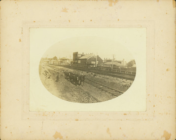
Photograph - Regrading the Camberwell Railway Line near Burke Road, E.J. Dower, 1915
One of a series of photographs, taken by Edgar James Dower in the second decade of the twentieth century. Born and raised in Olinda, his family later moved to Surrey Hills. He worked as an adult as a clerk in the city office of the Metropolitan Gas Company, and in his role as a 'collector', he was able to photograph scenes including the construction of tramlines, railways and associated buildings in Kew, Hawthorn, Camberwell and Surrey Hills. Later he established a real estate agency with his brother - the E.J. Dower Real Estate Agency, Dandenong Office.The image is an historically significant record of the development of transport infrastructure which was used to connect Victorians in the first two decades of the twentieth century. This development resulted from increases in population and the consequent extension of Melbourne's suburbs. The photographs, both individually and collectively, richly detail the labour of workers and the tools and machinery used to create and extend Melbourne's public transport network in the years preceding and during World War 1.Digital copy of an original oval mounted photograph depicting workers regrading the Camberwell Railway line following the demolition of the original Camberwell Railway Station. The level crossing gates at Burke Road can be seen in the distance. Named buildings include The Assembly Hall at right.Verso: "1915 / Regrading Camberwell railway line, near Burke Road / Taken by E.J.Dower."theme -- connecting victorians by transport and communications, theme - camberwell railway station, theme - travelling by train -
![Congregational Church, Walpole Street [Kew], 1977](/media/collectors/550653872162f11fb04854aa/items/58ce2f27d0ce2909d88dffec/item-media/58cf5dbbd0ce9d3314c36111/item-fit-380x285.jpg) Kew Historical Society Inc
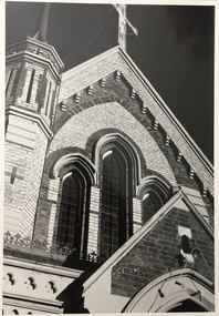
Kew Historical Society IncPhotograph, Unknown, Congregational Church, Walpole Street, 1977
The Congregational Church was built on the site of the first church in Kew. This church, the second on the site, was designed by the Kew architect Charles Vickers and opened in 1860. The distinctive polychrome brick façade designed by Vickers contrasted with the style that he employed for other churches he designed during this period; they were usually constructed in bluestone. In the 1960s, a new ministry saw the erection of a neon cross at the apex of the church. The illuminated cross could be seen from Church Street, Hawthorn. The church was later to be demolished, and the land sold for the construction of modern villas. The Kew Historical Society's Pictures Collection is comprised of photographs, postcards and original works of art. The photographs include original (mainly) images dating from the 1870s to the present. A number of these photographs derive from the former City of Kew's Civic Collection while others are the work of amateur and professional photographers. Most of the images in the collection depict people, places and objects within the suburbs of Kew and Kew East. Other photographs depict other locations in Melbourne and Victoria. A number of the photographs are of statewide and/or national significance.Congregational Church, Walpole Street, Kew, 1977 (now demolished). View of the polychrome facade facing Walpole Street. The use of polychrome brick by Alfred Purchas (the second architect) reflects his preference for this architectural style, such as in his design for Tarring (now Ruyton Girls' School)Inscriptions on reverse: "KH-99. Congregational Church Walpole St Kew. Built 1854. Now amalgamated with United Churches 1977."congregational church, walpole street (kew), charles vickers -
![Congregational Church, Walpole Street [Kew], 1977](/media/collectors/550653872162f11fb04854aa/items/58ce3037d0ce2f09d89eafac/item-media/58cf5d86d0ce9a3314909edb/item-fit-380x285.jpg) Kew Historical Society Inc
Kew Historical Society IncPhotograph, Unknown, Congregational Church, Walpole Street, 1977
The Congregational Church was built on the site of the first church in Kew. This church, the second on the site, was designed by the Kew architect Charles Vickers and opened in 1860. The distinctive polychrome brick façade designed by Vickers contrasted with the style that he employed for other churches he designed during this period; they were usually constructed in bluestone. In the 1960s, a new ministry saw the erection of a neon cross at the apex of the church. The illuminated cross could be seen from Church Street, Hawthorn. The church was later to be demolished, and the land sold for the construction of modern villas. Photograph of an historic church in Kew by noted architects Charles Vickers and Alfred Purchas.Congregational Church, Walpole Street, Kew, 1977 (now demolished). View of the polychrome facade facing Walpole Street. The use of polychrome brick by Alfred Purchas (the second architect) reflects his preference for this architectural style, such as in his design for Tarring (now Ruyton Girls' School)Inscriptions on reverse: "KH-100. Congregational Church Walpole St Kew. First church built in Kew 1860. Chapel on site 1854. Became a member of the United Churches 1970s". congregational church, walpole street (kew), charles vickers -
 Kew Historical Society Inc
Photograph, Congregational Church, Walpole Street, 1977
The Congregational Church was built on the site of the first church in Kew. This church, the second on the site, was designed by the Kew architect Charles Vickers and opened in 1860. The distinctive polychrome brick façade designed by Vickers contrasted with the style that he employed for other churches he designed during this period; they were usually constructed in bluestone. In the 1960s, a new ministry saw the erection of a neon cross at the apex of the church. The illuminated cross could be seen from Church Street, Hawthorn. The church was later to be demolished, and the land sold for the construction of modern villas.Congregational Church, Walpole Street, Kew, 1977 (now demolished). View of the polychrome facade facing Walpole Street. The use of polychrome brick by Alfred Purchas (the second architect) reflects his preference for this architectural style, such as in his design for Tarring (now Ruyton Girls' School) Inscriptions on reverse: "K.H.701. Congregational Church Walpole St Kew. First church in Kew. Now amalgamated with the United Churches."congregational church, walpole street (kew), charles vickers -
 Kew Historical Society Inc
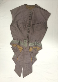
Clothing - Grey Silk Taffeta Bodice, 1880s
The Fashion & Design collection of the Kew Historical Society includes examples of women’s, men’s, children’s and infants’ clothing from the 18th, 19th and 20th centuries. Items in the collection were largely produced for, or purchased by women in Melbourne, and includes examples of outerwear, protective wear, nightwear, underwear and costume accessories. 1880s women's dress featured tightly fitting bodices with very narrow sleeves and high necklines, often trimmed at the wrists with white frills or lace. This example may have had its sleeves removed post construction.Grey coloured silk taffeta, ‘tailed’ woman’s waistcoat with cream silk panels. It would appear that the sleeves have been removed. women's clothing, fashion - melbourne - 1880s, bodices, vests -
 Port Fairy Historical Society Museum and Archives
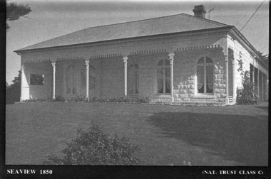
Souvenir - Postcard, Seaview 1850
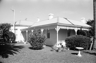
The construction of Seaview commenced in 1860, after David Talbot, purchased the land from James Atkinson,It had been suggested that it was intended to be double storied but there is no evidence of how that would have been accomplished. Following Talbot’s insolvency, Michael O’Reilly leased the house in 1862 until 1876 when he left for Melbourne.William Powling (Solicitor) acquired the house for Eight hundred and twenty three pounds in 1890 and lived there the rest of his life. His son Ernest Powling continued living there before selling it to Matthew Cathcart in 1917.A black and white photograph of the house called Seaview to be used as a postcard in a series by the National Trust Front of Seaview showing bay window and verandah bluestone painted whiteSeaview 1850 - Nat.Trust. CL1souvenir, port-fairy, seaview, powling, cathcart, talbot, o’reilly, house -
 Port Fairy Historical Society Museum and Archives
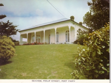
Postcard, Seaview Philip Street Port Fairy
The construction of Seaview commenced in 1860, after David Talbot, purchased the land from James Atkinson,It had been suggested that it was intended to be double storied but there is no evidence of how that would have been accomplished. Following Talbot’s insolvency, Michael O’Reilly leased the house in 1862 until 1876 when he left for Melbourne.William Powling (Solicitor) acquired the house for Eight hundred and twenty three pounds in 1890 and lived there the rest of his life. His son Ernest Powling continued living there before selling it to Matthew Cathcart in 1917.Coloured photograph of Front of Seaview showing bay window and verandahsouvenir, port-fairy, seaview, philip street, house -
 Port Fairy Historical Society Museum and Archives
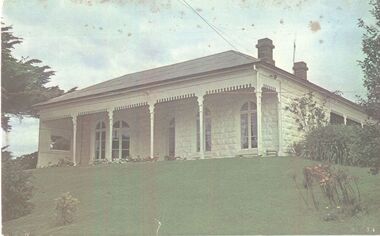
Photograph
The construction of Seaview commenced in 1860, after David Talbot, purchased the land from James Atkinson,It had been suggested that it was intended to be double storied but there is no evidence of how that would have been accomplished. Following Talbot’s insolvency, Michael O’Reilly leased the house in 1862 until 1876 when he left for Melbourne.William Powling (Solicitor) acquired the house for Eight hundred and twenty three pounds in 1890 and lived there the rest of his life. His son Ernest Powling continued living there before selling it to Matthew Cathcart in 1917.Coloured photograph of White painted stone house with bay window to right and large verandahcottage, building, home, house, seaview -
 Port Fairy Historical Society Museum and Archives
Negative - Photograph
The construction of Seaview commenced in 1860, after David Talbot, purchased the land from James Atkinson,It had been suggested that it was intended to be double storied but there is no evidence of how that would have been accomplished. Following Talbot’s insolvency, Michael O’Reilly leased the house in 1862 until 1876 when he left for Melbourne.William Powling (Solicitor) acquired the house for Eight hundred and twenty three pounds in 1890 and lived there the rest of his life. His son Ernest Powling continued living there before selling it to Matthew Cathcart in 1917.negative, seaview, house -
 City of Greater Bendigo - Civic Collection
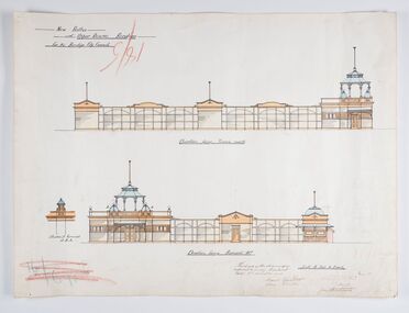
Work on paper - Architectural Drawing, City of Bendigo, New Baths at Upper Reserve Bendigo for the Bendigo City Council, 18th November 1912
The 'New' City of Bendigo baths also known as 'The Baths' were opened on 26th February,1913 at a cost of £2000. These baths made use of an existing dam and had men only and ladies bathing areas as well as a 'paddling paddock' for young children. This set of plans is for the Men's Bathing shed which serviced the men's bathing area adjacent to the still existing tennis courts on Barnard Street. In 1958 the Municipal Baths were replaced by an Olympic Pool and £17,000 was raised by public subscription towards this pool’s construction. Ink, pen, pencil and watercolour architectural drawing for the proposed new baths at the Upper Reserve on Barnard Street, Bendigo.New baths / at Upper Reserve Bendigo / for the Bendigo City Council / Elevation facing tennis courts / Elevation of Terminals at A, A, / Elevation facing Barnard Street / This is one of the drawings /referred to in my contract/ dated 18th November 1912 / Signed Robert J Rogers / (unknown) / Mayor Jas Semmensbendigo swimming club, rosalind park, upper reserve bendigo, faith leech memorial swimming pool, bendigo baths, city of greater bendigo community groups -
 Wodonga & District Historical Society Inc
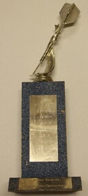
Award - Darts Trophy - A.W.D.D.A Winter '93 - A-Grade
The Terminus Hotel was one of the earliest hotels in Wodonga, with clear links to the establishment of the railway line. It was an important business and meeting place from the original construction in 1873 until 1st June 1998 the Terminus Hotel when it was destroyed by fire. It provided a popular venue for social activities, including competitive darts, both through its own competition and as part of the Albury-Wodonga District Darts Association. The remains of the building were demolished in 1999. This is a trophy for the Albury-Wodonga District Darts Association won by the team "Terminus Goers' in 1993.The Terminus Hotel was an important meeting place in Wodonga for more than 100 years. This item is representative of one of the social and sporting activities it provided for members of the local community.A trophy made from timber and metal with a representation of a dart on the top.On plaque lower front "A.W.D.D.A WINTER '93/A GRADE PREMIERS TERMINUS GOERS" In vertical list "B. TINGWELL (C) S. GRIFFITHS J. DE KRUIFF A. GARDNER R. GARDNER L. SIMS W. KILPATRICK B. SNEDDONterminus hotel, terminus hotel darts, sport and recreation wodonga -
 Wodonga & District Historical Society Inc
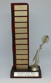
Award - Darts Trophy - Terminus Dart Club Doubles Championship, 1985
The Terminus Hotel was one of the earliest hotels in Wodonga, with clear links to the establishment of the railway line. It was an important business and meeting place from the original construction in 1873 until 1st June 1998 the Terminus Hotel when it was destroyed by fire. It provided a popular venue for social activities, including competitive darts, both through its own competition and as part of the Albury-Wodonga District Darts Association. The remains of the building were demolished in 1999. This is a perpetual trophy for the Terminus Dart Club Doubles Championship from 1985 to 1992.The Terminus Hotel was an important meeting place in Wodonga for more than 100 years. This item is representative of one of the social and sporting activities it provided for members of the local community.A wood and metal engraved trophy with stylised dart mounted on the side.At base: " TERMINUS DART CLUB/ DOUBLES CHAMPIONSHIP" On vertical list - top to bottom 1985 J. DEKRUIFF/ H. DEKRUIFF 1985 R. HUDSON/ A. FLEMING 1986 K. COOK/ H.M. COOK 1986 TONY LOWE / K.A.COOK 1987 J. DEKRUIFF/ A. FLEMING 1987 L. STOKES / K. MERRILESS 1988 J. DEKRUIFF/ T. LOWE 1989 ROB BENNETT/ B. STEWART 1989 L. BRUCE/B. STEWART 1991 J. DEKRUIFF/ P. HOLLINGSWORTH 1992 B. TINGWELL/ S. GRIFFITHS 1992 B. TINGWELL / C. BLUNDEN terminus hotel darts, terminus hotel wodonga, sport and recreation -
 Melbourne Legacy
Document, Residences
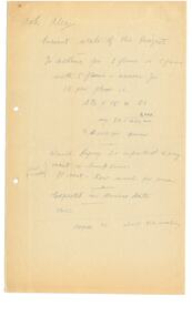
Handwritten anonymous notes, possibly 1971, headed "Ask Alec" and identifying information the writer needed such as 'Present state of the project'. There is no indication of what the project was beyond dates for the acceptance of tenders, start of construction and date of completion etc. Appears to be part of the review of the residences done at that time. When ideas for renovating and upgrading one of the homes was being considered. Apparently building would start in March 1972 and be completed before the end of 1972. There is no record of a Legatee called 'Alec' at the appropriate time in Melbourne Legacy records.Part of the history of Melbourne Legacy's involvement with residential care for children.2 pencilled foolscap sheets, black on discoloured white. Two holes punched for filing. residences, review -
 Melbourne Tram Museum
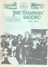
Magazine, Australian Tramway & Motor Omnibus Employees Association (ATMOEA), The Tramway Record", June 1983
The tram union journal "The Tramway Record", published by ATMOEA Vic Branch, June 1983 with a photo of John Cain, Premier of Victoria opening the new tramway to Bolderwoood Parade 18/5/1983. Has a photo on page 7 of W7 1001, when new running in High St Northcote during the construction of the line which was done in two halves. Has news from the various depots, industrial and political news and an article on page 13 about the Ballarat Tramway Preservation Society and its operations.Yields information about the Union activities and news in June 1983.Magazine 34 printed pages, side stapled with light green cover sheets.tramways, unions, atmoea, btps, opening, bolderwood parade -
 Falls Creek Historical Society
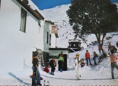
Postcard - The Frying Pan Inn, Falls Creek
With the completion of the Kiewa Hydroelectric Scheme in 1959, Falls Creek began to change from being a construction site into an alpine tourism resort. In 1964 the Frying Pan Inn group consisting of Bill Bridgford, Geof Henke and L G Morrison acquired a license to construct a restaurant. It opened in time for the 1965 season, but the Frying Pan venue was damaged by fire in 1967. Renovations took until 1973 when the Frying Pan Inn reopened. It is now a popular Apres Ski location in the heart of Falls Creek Village.This postcard depicts a popular venue at Falls Creek.A postcard featuring a coloured photograph of the Frying Pan Inn. It has a title and publisher details on the reverse.In image: Sign - Frying Pan Inn Licensed Restaurant On reverse: Top Left: FALLS CREEK, Victoria, Australia /Frying Pan Inn and Summit beyond. Centre: Nu-Color- Vue of AUSTRALIA In stamp square: FC 12 NCV 2562 Publisher information vertically down centre: NUCOLORVUE PRODUCTIONS PTY. LTD./ COPYRIGHT PRINTED IN AUSTRALIAfalls creek village, frying pan inn, falls creek tourism -
 Melbourne Tram Museum
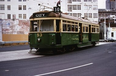
Slide, Tramway Museum Society of Victoria (TMSV), Tram VR 53 La Trobe St, c1974
Colour slide of VR class tram 53, route 30, westbound in La Trobe St on the bypass built to enable the construction of the Melbourne Central or Museum station between Dec 1973 and 1978 - see reference. The concrete looks relatively new in the photograph. The tram was originally built by the Victorian Railways for their St Kilda Brighton tramway in 1942. It is currently on display at the Melbourne Tram Museum. Many of the buildings in the background have since been demolished. The former Myer warehouse can be seen in the top right-hand corner of the photo.Yields information about VR tram 53 and Latrobe St c1974.Kodachrome colour slides, cardboard mount.Has "MP146" in pencil and stamped "Tramways Museum Society Victoria" on rear.tramways, vr class, tram 53, route 30, latrobe st -
 Emerald Museum & Nobelius Heritage Park
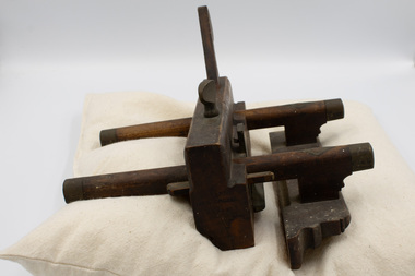
Tool - Plough Plane, Jenkins & Clark, Circa late 19th century
This plough plane is a hand tool that was used to cut grooves or rabbets into wood, for example for furniture construction. It was manufactured in Birmingham by Jenkins & Clark and imported or taken to Australia most likely in the nineteenth century. The several names imprinted into the tool imply that it may have been used by several unique owners at different points in time - J.O. Hart, Micl (likely Michael) Orgill, and D. Brown. Names may have been imprinted in the tool to prevent confusion in settings with many workers supplying their own tools.Unknown donor but assumed to have been used locally.Wooden plough plane with brass fittings. Includes adjustable wooden clamp and removable wooden blade clamp. The blade slot cuts diagonally through the object. There are inscriptions on both shorter ends of the object.On side opposite blade slot: 'JENKINS/&/CLARK/J.O.HART/MICL ORGILL/J.O.HART/D. BROWN' On side near blade slot: 'D. BROWN/[upside-down] J.O.HART/MICL ORGILL/[upside-down] J.O.HART'plough plane, tools, jenkins & clark -
 Melbourne Tram Museum
Ephemera - Greetings card - Swanston St at Collins St - cable trams, Jack Cranston, c1905
Greetings card with a photo of Swanston St looking south from Collins St. On the left side of the photo is a cable tram signal shelter with a signal man at the levers. A St Kilda tram is southbound. Image prior to the construction of Flinders St station building. The Water Tower clock is visible at Princes Bridge Station - see reference. It was moved from Elizabeth St to Princes Bridge in 1902. The card was produced Jack Cranston and published for Glencon Insurance Assessors. See item 8448 for images of the card itself.Yields information about cable trams in Swanston St and a cable tram signalmen c1905.Greetings card with a colour photograph, printed on stippled paper.tramcars, tramways, cable trams, mtoco, swanston st, signalmen -
 Ballarat Tramway Museum
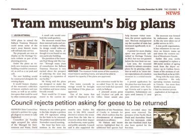
Newspaper, The Courier Ballarat, "Tram Museum's big plans", Dec. 2019
Set of 7 items related to the proposed extension of the BTM's depot to the south, Dec. 2019. Comprises: .1 - Newspaper clipping from The Courier, 19/12/2019 titled "Tram Museum's big plans", advising that the proposal was being advertised by Heritage Victoria, along with a photo of No. 26. .2 - Newspaper clipping from The Courier, 18/12/2019 for the advertising the permit application under the Heritage Act 2017 - in the Public Notice section. .3 - Digital image of "Museum Extension - Heritage Impact Statement - revised Oct. 2019." - 16 A4 pages. .4 - Digital image of Plans - 8 sheets of the proposal by MKM constructions. .5 - Digital image of Report - Urber Arbor - Arboricultural Report - Tree Management Plan. .6 - Digital image of Coloured site plan and drawings showing proposal depot trackwork and support mechanism around trees. Note this does not open on dbTextWorks interface. .7 - Digital image of 11 sheets of concept plans for the exterior and interior of the museum proposal by MKM Constructions. .8 - digital image of the advertising sign on the rear wall of the depot taken 7-1-2019. A similar poster was on the south east corner of the depot.btm, museum, drawings, depot extensions, heritage buildings, heritage, trackwork -
 Kew Historical Society Inc
Plan, Melbourne & Metropolitan Board of Works. Borough of Kew Detail Plan No.1579, 1904
The Melbourne and Metropolitan Board of Works (MMBW) plans were produced from the 1890s to the 1950s. They were crucial to the design and development of Melbourne's sewerage and drainage system. The plans, at a scale of 40 feet to 1 inch (1:480), provide a detailed historical record of Melbourne streetscapes and environmental features. Each plan covers one or two street blocks (roughly six streets), showing details of buildings, including garden layouts and ownership boundaries, and features such as laneways, drains, bridges, parks, municipal boundaries and other prominent landmarks as they existed at the time each plan was produced. (Source: State Library of Victoria). This plan forms part of a large group of MMBW plans and maps that was donated to the Society by the Mr Poulter, City Engineer of the City of Kew in 1989. Within this collection, thirty-five hand-coloured plans, backed with linen, are of statewide significance as they include annotations that provide details of construction materials used in buildings in the first decade of the 20th century as well as additional information about land ownership and usage. The copies in the Public Record Office Victoria and the State Library of Victoria are monochrome versions which do not denote building materials so that the maps in this collection are invaluable and unique tools for researchers and heritage consultants. A number of the plans are not held in the collection of the State Library of Victoria so they have the additional attribute of rarity.Original survey plan, issued by the MMBW to a contractor with responsibility for constructing sewers in the area identified on the plan within the Borough of Kew. The plan was at some stage hand-coloured, possibly by the contractor, but more likely by officers working in the Engineering Department of the Borough and later Town, then City of Kew. The hand-coloured sections of buildings on the plan were used to denote masonry or brick constructions (pink), weatherboard constructions (yellow), and public buildings (grey). While MMBW Plan No.1579 does not include many buildings, those that it does show are significant to Kew’s history. These include the ‘Kew [Railway] Station’ in Denmark Street and the ‘Recreation Hall’ and rear courts off Wellington Street. The plan shows the outline of the Recreation Hall, constructed in 1880, at the rear of which is listed a bowling green, two tennis courts, a ‘skittle alley’ and a pavilion. When the Hall was first built, the Kew Cricket Club occupied an adjacent ground, however in 1885 this was acquired by the State Government as the future location of the Kew Railway Station. The Plan also shows a single oval at Xavier College. This oval was completed in 1883. One of the current ovals conforms to this oval’s original shape and position in the school grounds.melbourne and metropolitan board of works, detail plans, maps - borough of kew, mmbw 1579, cartography -
 Kew Historical Society Inc
Plan, Melbourne & Metropolitan Board of Works / Borough of Kew, Detail Plan No.1593, 1905
The Melbourne and Metropolitan Board of Works (MMBW) plans were produced from the 1890s to the 1950s. They were crucial to the design and development of Melbourne's sewerage and drainage system. The plans, at a scale of 40 feet to 1 inch (1:480), provide a detailed historical record of Melbourne streetscapes and environmental features. Each plan covers one or two street blocks (roughly six streets), showing details of buildings, including garden layouts and ownership boundaries, and features such as laneways, drains, bridges, parks, municipal boundaries and other prominent landmarks as they existed at the time each plan was produced. (Source: State Library of Victoria)This plan forms part of a large group of MMBW plans and maps that was donated to the Society by the Mr Poulter, City Engineer of the City of Kew in 1989. Within this collection, thirty-five hand-coloured plans, backed with linen, are of statewide significance as they include annotations that provide details of construction materials used in buildings in the first decade of the 20th century as well as additional information about land ownership and usage. The copies in the Public Record Office Victoria and the State Library of Victoria are monochrome versions which do not denote building materials so that the maps in this collection are invaluable and unique tools for researchers and heritage consultants. A number of the plans are not held in the collection of the State Library of Victoria so they have the additional attribute of rarity.Original survey plan, issued by the MMBW to a contractor with responsibility for constructing sewers in the area identified on the plan within the Borough of Kew. The plan was at some stage hand-coloured, possibly by the contractor, but more likely by officers working in the Engineering Department of the Borough and later Town, then City of Kew. The hand-coloured sections of buildings on the plan were used to denote masonry or brick constructions (pink), weatherboard constructions (yellow), and public buildings (grey). The laborious task of hand-tinting these Board of Works plans was not without hazards as is evidenced by Plan No. 1593. On the Plan, the original colourist spilt black and green ink, partially obscuring some parts. The most obvious casualty is ‘Clifton’ located on the corner of Cotham Road and Park Street [now Adeney Avenue]. Included in this Plan, and outlined in pink is that part of the section that the contracting engineer was tasked with completing. This included sewering on both sides of this part of Cotham Road, but excluded properties such as ‘Glendonald’ and ‘Monnington’. This area was to undergo a series of subdivisions including the ‘Clifton Estate’, which created housing lots on Adeney Avenue and Florence Avenue in 1916. The most notable occupant of Clifton was William Adeney [died 1893], a pioneer of Camperdown, after which Park Street was later renamed.melbourne and metropolitan board of works, detail plans, survey plans - borough of kew, mmbw 1593, cartography -
 Kew Historical Society Inc
Plan, Melbourne & Metropolitan Board of Works : Borough of Kew : Detail Plan No.1291, 1905
The Melbourne and Metropolitan Board of Works (MMBW) plans were produced from the 1890s to the 1950s. They were crucial to the design and development of Melbourne's sewerage and drainage system. The plans, at a scale of 40 feet to 1 inch (1:480), provide a detailed historical record of Melbourne streetscapes and environmental features. Each plan covers one or two street blocks (roughly six streets), showing details of buildings, including garden layouts and ownership boundaries, and features such as laneways, drains, bridges, parks, municipal boundaries and other prominent landmarks as they existed at the time each plan was produced. (Source: State Library of Victoria). This plan forms part of a large group of MMBW plans and maps that was donated to the Society by the Mr Poulter, City Engineer of the City of Kew in 1989. Within this collection, thirty-five hand-coloured plans, backed with linen, are of statewide significance as they include annotations that provide details of construction materials used in buildings in the first decade of the 20th century as well as additional information about land ownership and usage. The copies in the Public Record Office Victoria and the State Library of Victoria are monochrome versions which do not denote building materials so that the maps in this collection are invaluable and unique tools for researchers and heritage consultants. A number of the plans are not held in the collection of the State Library of Victoria so they have the additional attribute of rarity.Original survey plan, issued by the MMBW to a contractor with responsibility for constructing sewers in the area identified on the plan within the Borough of Kew. The plan was at some stage hand-coloured, possibly by the contractor, but more likely by officers working in the Engineering Department of the Borough and later Town, then City of Kew. The hand-coloured sections of buildings on the plan were used to denote masonry or brick constructions (pink), weatherboard constructions (yellow), and public buildings (grey). A detail plan of part of Studley Park bordered by the major streets of Hodgson Street, Stevenson Street and Studley Park Road. Included on the plan are a number of significant Studley Park mansions in existence at the beginning of the 20th century. The unnamed street shown in the middle of the plan is McEvoy Street. The most important house still extant is Campion House, formerly named Dalsraith [Dalswraith] and Glendalough, owned since the 1940s by the Society of Jesus. Campion House can be seen on the corner of Hodgson and Studley Park Road. Its stables at the rear of the block have now been incorporated into a contemporary residence. An interesting feature of the plan is the 1910 annotation by Ed Seitz, professional designing engineer. Is Seitz the contractor who modified the MMBW original?melbourne and metropolitan board of works, detail plans, mmbw 1291, cartography -
 Kew Historical Society Inc
Plan, Melbourne & Metropolitan Board of Works : Borough of Kew : Detail Plan No.1564, 1905
The Melbourne and Metropolitan Board of Works (MMBW) plans were produced from the 1890s to the 1950s. They were crucial to the design and development of Melbourne's sewerage and drainage system. The plans, at a scale of 40 feet to 1 inch (1:480), provide a detailed historical record of Melbourne streetscapes and environmental features. Each plan covers one or two street blocks (roughly six streets), showing details of buildings, including garden layouts and ownership boundaries, and features such as laneways, drains, bridges, parks, municipal boundaries and other prominent landmarks as they existed at the time each plan was produced. (Source: State Library of Victoria)This plan forms part of a large group of MMBW plans and maps that was donated to the Society by the Mr Poulter, City Engineer of the City of Kew in 1989. Within this collection, thirty-five hand-coloured plans, backed with linen, are of statewide significance as they include annotations that provide details of construction materials used in buildings in the first decade of the 20th century as well as additional information about land ownership and usage. The copies in the Public Record Office Victoria and the State Library of Victoria are monochrome versions which do not denote building materials so that the maps in this collection are invaluable and unique tools for researchers and heritage consultants. A number of the plans are not held in the collection of the State Library of Victoria so they have the additional attribute of rarity.Original survey plan, issued by the MMBW to a contractor with responsibility for constructing sewers in the area identified on the plan within the Borough of Kew. The plan was at some stage hand-coloured, possibly by the contractor, but more likely by officers working in the Engineering Department of the Borough and later Town, then City of Kew. The hand-coloured sections of buildings on the plan were used to denote masonry or brick constructions (pink), weatherboard constructions (yellow), and public buildings (grey). In 1905, when Plan No.1564 was printed, that part of Kew bordered by Brougham Place (now Daniell Place), Mount Street, Sackville Street and Ross Street was already the location of a number of large mansions. Here, subdivisions, at least at this stage, produced larger blocks than in Central Kew. Many of the houses on this plan are named: ‘Faybrook’, ‘Northumbria’, ‘Parkholm[e]’, ‘Dunboe’, ‘Katoomba’ and ‘Eschol’ fronting Sackville Street. Eschol was once the home of the manufacturer Robert Harrison, whose cordial factory in Spring and Argyle Streets Fitzroy are noted on the Victorian Heritage Register. ‘The Hawthorns’ on the corner of Brougham Place and Mount Street was the home of the medical practitioner Frank William Fay, who won the military cross and other honours for conspicuous gallantry and devotion to duty in World War 1.melbourne and metropolitan board of works, detail plans, mmbw 1564, cartography -
 Kew Historical Society Inc
Plan, Melbourne & Metropolitan Board of Works : Borough of Kew : Detail Plan No.1570, 1905
The Melbourne and Metropolitan Board of Works (MMBW) plans were produced from the 1890s to the 1950s. They were crucial to the design and development of Melbourne's sewerage and drainage system. The plans, at a scale of 40 feet to 1 inch (1:480), provide a detailed historical record of Melbourne streetscapes and environmental features. Each plan covers one or two street blocks (roughly six streets), showing details of buildings, including garden layouts and ownership boundaries, and features such as laneways, drains, bridges, parks, municipal boundaries and other prominent landmarks as they existed at the time each plan was produced. (Source: State Library of Victoria)This plan forms part of a large group of MMBW plans and maps that was donated to the Society by the Mr Poulter, City Engineer of the City of Kew in 1989. Within this collection, thirty-five hand-coloured plans, backed with linen, are of statewide significance as they include annotations that provide details of construction materials used in buildings in the first decade of the 20th century as well as additional information about land ownership and usage. The copies in the Public Record Office Victoria and the State Library of Victoria are monochrome versions which do not denote building materials so that the maps in this collection are invaluable and unique tools for researchers and heritage consultants. A number of the plans are not held in the collection of the State Library of Victoria so they have the additional attribute of rarity.Original survey plan, issued by the MMBW to a contractor with responsibility for constructing sewers in the area identified on the plan within the Borough of Kew. The plan was at some stage hand-coloured, possibly by the contractor, but more likely by officers working in the Engineering Department of the Borough and later Town, then City of Kew. The hand-coloured sections of buildings on the plan were used to denote masonry or brick constructions (pink), weatherboard constructions (yellow), and public buildings (grey). Plan No.1570 shows the layout of gardens and houses in Sackville Street, Davis Street, Wrixon Street, and Fitzwilliam Street in 1904. While Thomas Street is included on the map, at this stage no houses had been built. The plan identifies two named houses: ‘Fairview’ and ‘Kylemore’. Fairview is more fully delineated in Plan No.1563. Kylemore is one of the few houses in Kew designed by John Beswicke. The most notable owner of Kylemore was William Whitehead, who owned the house between 1895 and 1900. In 1894, Australian newspapers reported the marriage of Whitehead’s daughter to Dr. Gerald Eugene Cussen, the brother of Sir Leo Cussen, the Supreme Court Judge. The married couple was to live at ‘Wilton’ (now the Kew RSL) from 1911-15.melbourne and metropolitan board of works, detail plans, mmbw 1570, cartography