Showing 965 items matching " brighton road"
-
 City of Moorabbin Historical Society (Operating the Box Cottage Museum)
Book, Brighton Cemetorians Inc, Time Lines of the Brighton General Cemetery : Visits to the Cemetery over many years
... Cottage Museum) Joyce Park Jasper Road Ormond melbourne Brighton ...The Brighton General Cemeterynon-fictionThe Brighton General Cemeterybrighton general cemetery, brighton, cemetery -
 City of Moorabbin Historical Society (Operating the Box Cottage Museum)
Book, Brighton Cemetorians Inc, Our Men & Women of WW1
... Cottage Museum) Joyce Park Jasper Road Ormond melbourne Brighton ...Men & women of WW1 buried in the Brighton Cemeterynon-fictionMen & women of WW1 buried in the Brighton Cemeterybrighton general cemetery, brighton, cemetery, artists -
 City of Moorabbin Historical Society (Operating the Box Cottage Museum)
Book, Brighton Cemetorians Inc, Our Gallipoli Boys : The centenary of Gallipoli
... Cottage Museum) Joyce Park Jasper Road Ormond melbourne Brighton ...Boyd who fought at Gallipoli and buried in the Brighton Cemeterynon-fictionBoyd who fought at Gallipoli and buried in the Brighton Cemeterybrighton general cemetery, brighton, cemetery, artists -
 Bendigo Historical Society Inc.
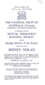
Document - ART OF SIDNEY NOLAN, PROGRAM FOR EXHIBITION BENDIGO 1972, 07/08/1972
Three copies of program for an art exhibition August 7 until August 11, 1972. Those associated with the exhibition are: City of Bendigo, The National Trust of Australia (Victoria) Central Victorian Branch, Mutual Permanent Building Society, Mrs D. I. Nolan and the Australian Galleries. The brochure names the twelve paintings, on exhibition by Sidney Nolan and Portrait of Sidney Nolan, by Christine Backhaus. There is also a short biography on Sidney Nolan. Handwritten in the top right corner of one copy is: Bush 1972.art, document, art of sidney nolan, city of bendigo, the national trust of australia (victoria) central victorian branch, mutual permanent building society, sidney nolan, cr d e elliott, colonel s r birch o b e, australian galleries, christine backhaus, the age, sidney henry nolan, dora irene nolan (sutherland), mrs l sweet, mrs m goslin, brighton technical school, raymond nolan, malcolm goslin, prahran technical school, national gallery art school, serge lifar, icarus, colonel de basil, kelly gang, unesco gallery paris, paradise gardens, her majesty the queen, arts centre st kilda road, prince phillip, lord snowdon, rev. fr. j p stockdale, mr a j watts, rosalind landells, feargus niall, mari mullins, brian mcgrath, bush -
 Bendigo Historical Society Inc.
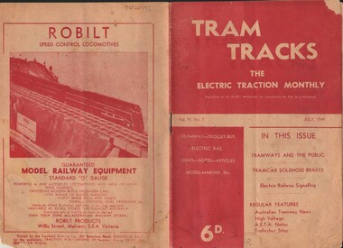
Document - BASIL MILLER COLLECTION: TRAMS - JOURNAL 'TRAM TRACKS', July 1949
Journal of Australian Electric Traction Association, Volume IV, No. 7, July 1949, 12 pages. History of document: Part of 'Basil Miller Collection'.Pub: Tractions Publications, 29 Seymour Grove, Brighton. Printer, Caulfield Printing co., 202 Balaclava Road., Caulfielddocument -
 Port Melbourne Historical & Preservation Society
Document - Notice, Land auction, Williamstown Road to Plummer Street, Port Melbourne, R Holden Stone, Borough Surveyor Brighton and Port Melbourne, Mar 1887
Large auction notice advertising sale of land Williamstown Road to Plummer Street 19.3.1887, with general (distorted) plan of Port Melborne and a larger plan of the allotmentstown planning, fishermans bend, land sales -
 St Kilda Historical Society
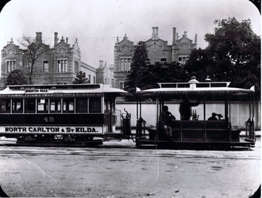
Photograph, CableTram, c. 1905
also stamped on back D.J. Taggartblack and white photograph1900. CableTram (North Carlton to St Kilda) in Lonsdale St, Melbourne about 1905. Brian Pump 36 Knaith road, Ringwood East. Phone: 8707001. Rathdowne, Lygon and Swanston sts and St Kilda rd. Rathdowne st to Brighton rd. 49 North Carlton and St Kilda. -
 Anglesea and District Historical Society
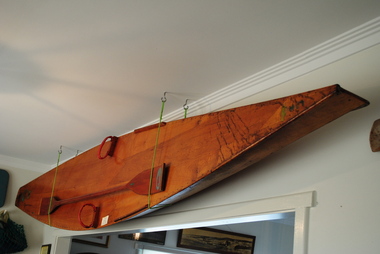
Surf Ski, C.W. Downie, Between 1935-1955
14 ft hollow plywood surfboard (ski) with paddle (wooden, double ended). Two foot holds, one on either side of board. Initials LBH (owner Basil Hunter) hand painted on pointy end of board.Built by C.R. Downie, Hampton, Victoria. A Downie Product 7 Higinbotham Street, Brighton. Victoria LBH printed on pointy end of board. surf ski, basil hunter -
 Uniting Church Archives - Synod of Victoria
Document - Invitation, Methodist Homes for Children New Domestic Economy School
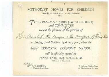
E3000.30.1 White card printed invitation to the Mayor and Mayoress of Brighton to the opening of the domestic economy school at the Methodist Homes for Children, Point Nepean Road, Cheltenham. E3000.30.2 Copy of reply sent. Typed on pink paper.methodist homes for children, tuckfield j w mrs, tate frank -
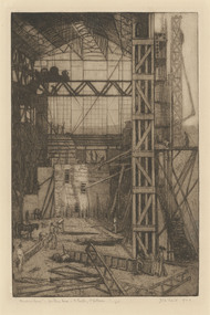 Latrobe Regional Gallery
Print, TRAILL, Jessie b. 1881 Brighton, Victoria d. 1967 Emerald, Victoria, Meccano House, 1923
Drypoint etchingTitled, edition 1/25, signed and dated 1923 under printed imagefactory, industrial, etching, architectural -
Whitehorse Historical Society Inc.
Map, Melbourne Geological Map, 1937
Geological Map of Melbourne & Suburbs.Geological Map of Melbourne & Suburbs. Scale: 40 chains to 1 inch with inset 10 miles to 1 inch. Includes Municipal and Parish boundaries, railways and stations, electric tramways, cable tramways, Post Offices and State schools. Area bounded by Braybrook, Preston, Blackburn & Brighton. Printed on linen.Geological Map of Melbourne & Suburbs. melbourne, maps -
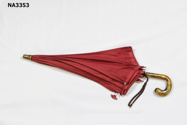 Whitehorse Historical Society Inc.
Functional object - Umbrella, c 1920
Donated by Christine Pitt, Whitehorse Historical Society member. Umbrella is from the 1920's, belonged to her mother, Fay Pitt of Box Hill, and her grandmother, Myrtle Grant of Richmond and Brighton.Red cotton umbrella with plastic handle and paint in a marble pattern. Ten black metal spokes are tipped with red, clear plastic. Wooden shaft. Material fastened with red elastic and metal button and eye clasp. Red material covers the join of spokes to shaft. Brown cotton cord fastened around shaft for hand-hold. From the 1920's'British Make' on one spoke.costume accessories, female -
 Whitehorse Historical Society Inc.
Print - Photograph, Windsor Family, c1940
By1880 most railway crossings were identified by a sign, although at very busy crossings a watchman was posted. Eventually most stations were manned and gates were installed. The watchman was generally housed in a small wooden or brick building with a clear view of the single line. The next stage was mechanical closing of the gates, using a lever situated in a shed behind the gatehouse. By 1956 automatic barriers had been installed. A working model of the gate style crossing can be seen at New Street Brighton.A collection of 12 black and white photographs of the Windsor family who lived in the gatehouse next to the Tunstall station. The stationmaster Ernest Windsor was also responsible for track maintenance between Ringwood and Middleborough Road Box Hill. His wife Betty Jean Windsor was gatekeeper for 2 years. On the back of each photograph are the names of the family members in the photo.Catherine Ann Windsor (born 1897), John Ernest (Ern) WIndsor, Catherine (Kitty) Windsor (born 1919), Patricia Janette WIndsor (born 1935) Tunstall Railway Gatesstationmasters, tunstall station, windsor ernest, windsor catherine, windsor patricia, windsor betty, windsor catherine (kitty) -
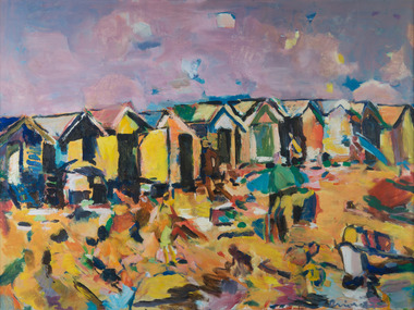 Kingston Arts
Painting, Elizabeth Prior, Summer Brighton, 1982
-
 Ballarat Tramway Museum
Photograph - Digital image, Dick Jones, W3 661 outbound in St Kilda Road, Dec. 1964
... Kilda Road East Brighton tram 661 Digital Image of MMTB tram W3 ...Demonstrates one of the Museum's trams in service in Melbourne.Digital Image of MMTB tram W3 661 outbound in St Kilda Road, approaching Doman Junction. Tram has destination of East Brighton, Route 64 and an advertisement for Proofkote (rain wear protection?) BP House in the background. Photo December 1964. Photo reference from Dick Jones - 661_StKildaRd_DickJones_6412MIns.23.04trams, tramways, w3 class, st kilda road, east brighton, tram 661 -
 Ballarat Tramway Museum
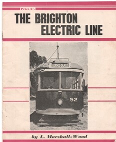
Book, Leon Marshall -Wood, "The Brighton Electric Line", 1956, 1958
.1 - Twenty page booklet on the history of the Brighton Electric Line by Leon Marshall-Wood, published 1956. Gives a brief history of the electric tramway operated by the Victorian Railways between St. Kilda Station and the Brighton Beach railway station, that commenced operation in 1905. The booklet was priced 2/-, published by the Traction Publications. Has 18 photographs, map 1905 and present day (when printed), rolling stock roster and notes and on the rear cover has details of the AETA. Front cover has horizontal crimson stripes. Has details of the AETA on the back cover and listing of some publications. Second copy from Ian Stanley added 24-1-2016. .2 - as for above - second edition, 1958, similar text, different photo layout and different front cover photo. See Reg Item 7631i for a scan of the 1966 edition.On front cover of first copy of .1 - top right hand corner; "N.Z.R.L.S / with compliments" and initials. Under title of book, "Price to Society 18/- Aust. per doz. / Retails 2/-" On page 3 of second copy of .1 - "Ian J Stanley 28 Park Road, South Camberwell, SE6, BK3746" On page 3 of .2 - "Ian J Stanley" in ink.trams, tramways, vr, melbourne, brighton, st kilda -
 Ballarat Tramway Museum
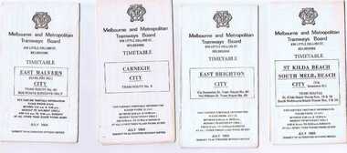
Ephemera - Timetable/s, Melbourne and Metropolitan Tramways Board (MMTB), Set of 24 MMTB Melbourne tram timetables, 1969
Set of 24 MMTB timetables for various routes, dated July 1969. Generally includes Sat and Suns, Good Friday and Christmas day as well as weekdays, unless noted otherwise. Also includes a map of the route, detailed time points, sections, connecting services, fares, and organisation address - 616 Little Collins St. Melbourne. Have been folded into ten portions. All on white paper unless noted otherwise. Items shown with an # - have a sticker modifying timetable information details on the front page. 1154.1 - Route 4 - Carnegie - City .2 - Route 4D - East Malvern (Darling Road) - City # .3 - Route 5 - Malvern Burk Road, - City # .4 - Route 6 - Glen Iris - City # .5 - Route 7 - Camberwell - City # .6 - Route 8 - Toorak - City # .7 - Routes 9, 10 and 12 - South Melbourne and St Kilda Beach - City (Brunswick St.) - via Collins St. .8 - Routes 10, 11 - West Preston and routes 9 & 9A Northcote .9 - Routes 15 & 22 - Moreland and 1 & 21 - East Coburg .10 - Route - 15 & 16 - St Kilda Beach and 1 & 2A - South Melbourne Beach - via Swanston St. .11 - Route 19 - North Coburg - City # .12 - Route 42 - Mont Albert - City # .13 - Routes 48 - North Balwyn and Burwood - City .14 - as above, but for Saturdays and Sundays on pink paper .15 - Routes 55 & 56, West Coburg - City - (William St.) - Domain Road. .16 - Route 57 - West Maribyrnong - City .17 - Route 59 - Essendon (Aerodrome) - City .18 - Route 64 & 65 - East Brighton - City .19 - Route 69 - Kew Cotham Road - St. Kilda Beach # .20 - Route 70 - Wattle Park - City # .21 - Routes 77 - Prahran - City, 78 - North Richmond - Prahran, 79 - North Richmond - St Kilda Beach .22 - Route 82 - Footscray to Moonee Ponds .23 - Route 88 - East Preston - City and Route 96, East Brunswick - City .24 - as above but for Saturdays and Sundays on pink paper. Images of a sample of documents added 16-11-2013.mmtb, timetables, melbourne -
 Ballarat Tramway Museum
Photograph - B&W print of donated negative, Ron E. Fluck, 7/04/1950 12:00:00 AM
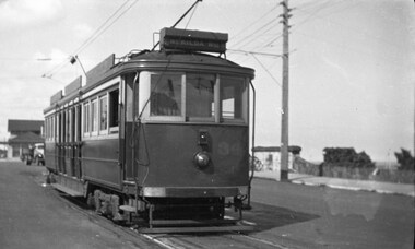
... /1998. Photo of Victorian Railway tram No.34 at the Brighton... Parade Ballarat Ballarat goldfields tramways trams Brighton Beach ...Black and white print of a donated negative. Print made 8/1998. Photo of Victorian Railway tram No.34 at the Brighton Beach terminus. Tram has the destination of "St Kilda Rly Stn". In the overhead can be seen the pan for assisting the driver to put the rear pole onto the wire. Also in the background of the photo is a stone wall of the railway tunnel under the road that served the Brighton Beach Pier. Photo taken 7-4-1950. See Victorian Railways to '62, pages 47 and 49 re railway tunnel.tramways, trams, brighton beach, vr, railway tunnel, tram 34 -
 Bendigo Historical Society Inc.
Photograph - HILDA HILL COLLECTION: BLACK AND WHITE PHOTOS, 1918
Series of black and white photos depicting The Hill family and friends during the post war years. Total number 9 photos. Two young ladies one seated in a deck chair and the other to the right standing with her right arm on the back of the chair, both girls wearing pinafores and white blouses at Brighton January 1918. Mog and two small girls all wearing white standing in front of a wooden structure and garden in background, Bendigo 1918. group of four girls and four boys, three of the girls are dressed in white and the fourth in a darker colour, one of the boys is wearing a white shirt and waistcoat two of them are in white shirts, two in middle background are indistinct, 17 Clive road January 1918. Double exposure gives the outline of a car in front of a white picket fence, right foreground at rear of car there is a group of adults and children that is indistinct for details, St Patrick's procession 1918 and family car. Rosa in light coloured dress with white collar, garden setting 'Moorilim' October 1918.Unnamed girl 'a Vision' wearing a white dress sitting on a wooden stump that is part of a building support, to left is a man in dark waistcoat and trousers with a white shirt sitting on the ground with his back to an axle with two large wheels, and a building support, Hibernian Picnic Axedale November 13 1918. Two ladies in foreground both wearing white, one also wears black hat and scarf, to left on stump is a light coloured hat and white coat, background has girl dressed in white blouse and dark skirt and further back can be seen more people, Hibernian Picnic 13 November 1918. 'three Merry maids' sitting on blanket on the ground two dressed in full white and third white top and dark dress, more people in the far background, Hibernian picnic Axedale 13 November 1918. Mrs Cavagna and Carmy, young girl dressed white dress with black belt and long white socks and black shoes, seated lady in white dress and dark hat with black veil, number of people in the far background, Hibernian picnic 13 November 1918.Hilda Hill Personal Collectionaustralia, history, post war life -
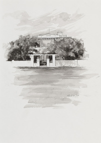
 Bayside Gallery - Bayside City Council Art & Heritage Collection
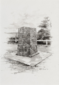
Work on paper - ink and watercolour, Annette Meikle, Moysey Memorial, 1977
In 1977, artist Annette Meikle undertook a commission to illustrate a book recording stories of places and people in the Bayside area. It was published in 1978 as Sandringham Sketchbook, with text by Elizabeth Waters. The sketches were intended to record remaining examples of Bayside’s early architecture and environment, as well as reflect newer architectural changes. Meikle went on to donate 22 of these sketches to Bayside City Council in 2003. Erected in 1964, this stone cairn on Beach Road in Beaumaris marks the site of the wattle and daub cottage of James and Susannah Moysey. James, Susannah and their cousin Nicholas arrived in Victoria in 1844 and leased land on the cliff-top. They built a cottage, cleared the land for sheep and cattle and established vegetable gardens. They later purchased the land and named it Beaumaris Park, derived from the name of the Welsh coastal resort where Edward I built Beau Marais castle.Annette Meikle, Moysey Memorial 1977, ink and watercolour, 35 x 23.5 cm. Bayside City Council Art and Heritage Collection. Donated by the artist, 2003annette meikle, sandringham sketchbook, elizabeth waters, port phillip bay, moysey memorial, coastline, stone cairn, james and susannah moysey, beaumaris -
 Bayside Gallery - Bayside City Council Art & Heritage Collection
Work on paper - ink and watercolour, Annette Meikle, Semco Park, 1977
In 1977, artist Annette Meikle undertook a commission to illustrate a book recording stories of places and people in the Bayside area. It was published in 1978 as Sandringham Sketchbook, with text by Elizabeth Waters. The sketches were intended to record remaining examples of Bayside’s early architecture and environment, as well as reflect newer architectural changes. Meikle went on to donate 22 of these sketches to Bayside City Council in 2003. Semco Park was a model of exemplary modern business in the 1920s. Located on Cheltenham Road, Black Rock, then considered to be an outer suburb, the property was home to Semco, a manufacturing and importing business of paper goods and cotton fabric items. The business’s governing director, Charles Mylius, wanted a firm that treated staff with fairness, created healthy and spacious working sites and offered recreational facilities. The site contained a factory as well as three houses for staff, a park with lawns, trees and flowerbeds, a cricket oval and a canteen serving hot food. Staff enjoyed soft background music played in the factory, and benefited from a superannuation scheme. Semco Park was sold to developers in 1977 but the business continued until the early 1990s with the office moving to Mulgrave, while factory work shifted to New Zealand.Annette Meikle, Semco Park 1977, ink and watercolour, 25.8 x 35.7 cm. Bayside City Council Art and Heritage Collection. Donated by the artist, 2003annette meikle, sandringham sketchbook, elizabeth waters, semco park, semco, cheltenham road, black rock -
 Bayside Gallery - Bayside City Council Art & Heritage Collection
Work on paper - ink and watercolour, Annette Meikle, Donald MacDonald Reserve, 1977
In 1977, artist Annette Meikle undertook a commission to illustrate a book recording stories of places and people in the Bayside area. It was published in 1978 as Sandringham Sketchbook, with text by Elizabeth Waters. The sketches were intended to record remaining examples of Bayside’s early architecture and environment, as well as reflect newer architectural changes. Meikle went on to donate 22 of these sketches to Bayside City Council in 2003. An area of natural bushland on Haydens Road, Beaumaris, was set aside in the early twentieth century as a reserve in memory of journalist and naturalist Donald MacDonald (c. 1859 – 1932). MacDonald was trained as a teacher but became a journalist for The Argus and The Australasian, working as a war correspondent, cricket commentator and nature writer. In 1900 he began the popular Argus column Nature notes and queries. Part of the Donald MacDonald Reserve was later cleared for an oval, a club pavilion and a scouts hall. Annette Meikle, Donald MacDonald Reserve 1977, ink and watercolour, 35.9 x 25.5 cm. Bayside City Council Art and Heritage Collection. Donated by the artist, 2003annette meikle, sandringham sketchbook, elizabeth waters, donald macdonald reserve, donald macdonald, journalist, naturalist, oval, sports pavilion, beaumaris -
 Bayside Gallery - Bayside City Council Art & Heritage Collection
Work on paper - ink and watercolour, Annette Meikle, Shenval, 1977
In 1977, artist Annette Meikle undertook a commission to illustrate a book recording stories of places and people in the Bayside area. It was published in 1978 as Sandringham Sketchbook, with text by Elizabeth Waters. The sketches were intended to record remaining examples of Bayside’s early architecture and environment, as well as reflect newer architectural changes. Meikle went on to donate 22 of these sketches to Bayside City Council in 2003. Built in 1891 for Captain Murray to his own design, ‘Shenval’ originally stood on five acres fronting Bluff Road, Black Rock.Annette Meikle, Shenval 1977, ink and watercolour, 33 x 23.5 cm. Bayside City Council Art and Heritage Collection. Donated by the artist, 2003annette meikle, sandringham sketchbook, elizabeth waters, black rock, architecture, historic house, shenval, captain murray, bluff road, verandah -
 Bayside Gallery - Bayside City Council Art & Heritage Collection
Work on paper - ink and watercolour, Annette Meikle, St Vincent de Paul's Children's Home, 1977
In 1977, artist Annette Meikle undertook a commission to illustrate a book recording stories of places and people in the Bayside area. It was published in 1978 as Sandringham Sketchbook, with text by Elizabeth Waters. The sketches were intended to record remaining examples of Bayside’s early architecture and environment, as well as reflect newer architectural changes. Meikle went on to donate 22 of these sketches to Bayside City Council in 2003. This red brick building in Balcombe Road, Black Rock, was constructed in the inter-war period (1939) as a holiday home for State wards and neglected children who were placed in the care of the Sisters of Mercy.Annette Meikle, St Vincent de Paul's Children's Home 1977, ink and watercolour, 35.7 x 25.6 cm. Bayside City Council Art and Heritage Collection. Donated by the artist, 2003annette meikle, sandringham sketchbook, elizabeth waters, st vincent de paul's children's home, balcombe road, black rock, sisters of mercy -
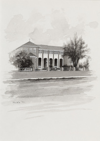
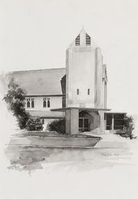 Bayside Gallery - Bayside City Council Art & Heritage Collection
Work on paper - ink and watercolour, Annette Meikle, Church of England, 1977
In 1977, artist Annette Meikle undertook a commission to illustrate a book recording stories of places and people in the Bayside area. It was published in 1978 as Sandringham Sketchbook, with text by Elizabeth Waters. The sketches were intended to record remaining examples of Bayside’s early architecture and environment, as well as reflect newer architectural changes. Meikle went on to donate 22 of these sketches to Bayside City Council in 2003. All Souls Memorial Church, located at 48 Bay Road, Sandringham, is believed to be the first reinforced concrete church in Australia. The foundation stone laid on 7 September 1919 and was consecrated in December 1921, the church seats 350 and contains an organ loft, a marble chancel floor, and Australian hardwood pulpit and pews.Annette Meikle, Church of England 1977, ink and watercolour, 35.6 x 25 cm. Bayside City Council Art and Heritage Collection. Donated by the artist, 2003annette meikle, sandringham sketchbook, elizabeth waters, all souls memorial church, church, building, architecture, bay road, sandringham, church of england -
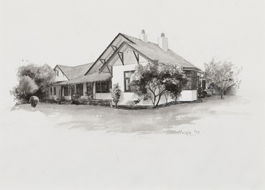 Bayside Gallery - Bayside City Council Art & Heritage Collection
Work on paper - ink and watercolour, Annette Meikle, Hollyburton, 1977
In 1977, artist Annette Meikle undertook a commission to illustrate a book recording stories of places and people in the Bayside area. It was published in 1978 as Sandringham Sketchbook, with text by Elizabeth Waters. The sketches were intended to record remaining examples of Bayside’s early architecture and environment, as well as reflect newer architectural changes. Meikle went on to donate 22 of these sketches to Bayside City Council in 2003. ‘Hollyburton’ was built in 1908 by the Honourable JV Fairbairn MHR and is notable for its Australian-style arts and crafts detailing. Located on Fernhill Road, Sandringham, it covered 930 square metres and included a servants’ wing.Annette Meikle, Hollyburton 1977, ink and watercolour, 25.8 x 35.6 cm. Bayside City Council Art and Heritage Collection. Donated by the artist, 2003annette meikle, sandringham sketchbook, elizabeth waters, hollyburton, honourable jv fairbairn mhr, arts and crafts, architecture, historic house, fernhill road, sandringham -
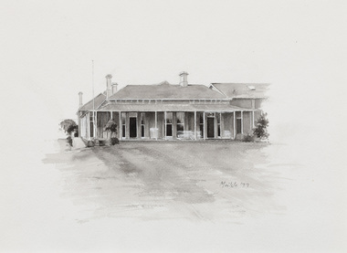 Bayside Gallery - Bayside City Council Art & Heritage Collection
Work on paper - ink and watercolour, Annette Meikle, Sandringham Club, 1977
In 1977, artist Annette Meikle undertook a commission to illustrate a book recording stories of places and people in the Bayside area. It was published in 1978 as Sandringham Sketchbook, with text by Elizabeth Waters. The sketches were intended to record remaining examples of Bayside’s early architecture and environment, as well as reflect newer architectural changes. Meikle went on to donate 22 of these sketches to Bayside City Council in 2003. In the mid 1870s wealthy solicitor David Abbot bought a large block on the corner of Bamfield Street and Beach Road and built an imposing family home with a stately tower. It featured rare Hawthorn Blacks – hand-made bricks of brown-red with streaks of charcoal black. For many years the home was the most prominent in the district. In 1922 ‘Coggeshall’ was subdivided, and the house was sold to the Sandringham Club, a gentleman’s club that had formed in 1913 and required more space for its growing membership. Members enjoyed lawn tennis courts, a bowling green and a cricket green, as well as a large billiard room. The Sandringham Club still owns ‘Coggeshall’.Annette Meikle, Sandringham Club 1977, ink and watercolour, 25.7 x 35.7 cm. Bayside City Council Art and Heritage Collection. Donated by the artist, 2003annette meikle, sandringham sketchbook, elizabeth waters, sandringham, sandringham club, gentleman’s club, coggeshall, david abbot, historic house -
 Bayside Gallery - Bayside City Council Art & Heritage Collection
Work on paper - ink and watercolour, Annette Meikle, Karinga, 1977
In 1977, artist Annette Meikle undertook a commission to illustrate a book recording stories of places and people in the Bayside area. It was published in 1978 as Sandringham Sketchbook, with text by Elizabeth Waters. The sketches were intended to record remaining examples of Bayside’s early architecture and environment, as well as reflect newer architectural changes. Meikle went on to donate 22 of these sketches to Bayside City Council in 2003. This inter-war house located at 60 Bluff Road, Black Rock, was built in 1926 for former Scotland Yard and Criminal Investigation Branch detective Horatio Reginald Clarence McWilliams. When McWilliams died it was found that he had taken extreme measures to protect his security. All the windows were nailed shut, a network of burglar alarms ran through the house and a complicated underground air raid shelter had been built in the garden. The security measures were at odds with the name of the house – Karinga or Karinya – an Aboriginal word meaning peaceful, happy home. Later residents of ‘Karinga’ included Senator Don Chipp and his family. The property has since been demolished and apartments have been built on the land.Annette Meikle, Karinga 1977, ink and watercolour, 32 x 23.5 cm. Bayside City Council Art and Heritage Collection. Donated by the artist, 2003annette meikle, sandringham sketchbook, elizabeth waters, black rock, karinga, karinya, horatio reginald clarence mcwilliams, senator don chipp, historic house, bluff road -
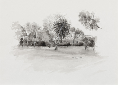
 Bayside Gallery - Bayside City Council Art & Heritage Collection
Map, H.B. Foot, Plan of the Brighton Estate containing 5120 acres, first special survey at Port Phillip, c. 1842
This plan records the Brighton Estate, also known as Dendy's Special Survey. In 1840 Henry Dendy, a farmer in Surrey, England acquired a "Special Survey" from the Commissioners for Land and Emigration which gave him the right to choose land in Port Phillip for the low price of £1 per acre for 5120 acres. Dendy appointed Jonathan Binns Were, as his agent, who later became a partner. Together, Dendy and Were decided on an area 5 miles south from Melbourne, bounded by North Road, East Boundary Road, South Road and to the west by Port Phillip Bay. Their Brighton Estate was first surveyed by T. S. Townsend in May 1841 and was re-surveyed by Robert Hoddle. Dendy and Were were making plans to sell the land and advertised a 30-guinea prize for the best subdivision which was to be divided into a village, marine residences, suburban and cultivation allotments, with the remainder being divided into country sections. The competition was won by H.B. Foot, who planned the village around a reserve and crescents and a 'green belt' forming the town boundary. brighton estate, dendy's special survey, special survey, henry dendy, jonathan binns were, w.b. were, survey, plan, map, brighton, george ward cole, baker's lithographer, hibernian, subdivision, town planning, cartographic material, h.b. foot -
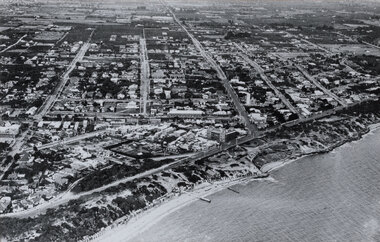 Bayside Gallery - Bayside City Council Art & Heritage Collection
Photograph, W.H. Hansom, Sandringham, 1921
sandringham, aerial, coast, bathing box, w.h. hansom, victoria, suburbs, photograph, airspy, beach street, bay road, abbott street, sandringham hotel