Showing 6760 items matching " rivers"
-
 Marysville & District Historical Society
Postcard (item) - Colour postcard, Rose Stereograph Company, Greetings from MARYSVILLE, Victoria, Pre 2009
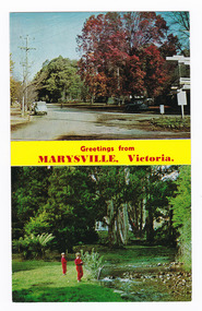
A postcard with two colour photographs taken in Marysville in Victoria.A postcard with two colour photographs taken in Marysville in Victoria. The top photograph was taken on the corner of Murchison Street and Pack Road and shows an iconic wooden direction sign. The other is taken along the Steavenson River in Marysville. Murchison Street is Marysville's main street and is where most of the businesses in Marysville are. This postcard was produced by the Rose Stereograph Co as a souvenir of Marysville. Rose Series Colorview No. 348.POST CARD The "Rose" Series/ De Luxe Produced in Australia Signpost Corner At Marysville, Victoria. Stevenson's River, Marysville, Victoria Rose Series Colorview No. 348 Published by the Roe Stereograph Co., Armadale, Victoria.marysville, victoria, signpost, steavenson river, rose stereograph co, postcard, souvenir -
 Kew Historical Society Inc
Photograph - Former Chandler Highway Bridge, 2001
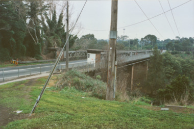
The heritage listed Fairfield Bridge was originally constructed for the Outer Circle Railway to bridge the Yarra River between East Kew and Fairfield stations. In the 1930s it was converted for vehicular traffic. In the 2010s a new concrete bridge was erected beside it to increase vehicular capacity. Original colour print positive of the (former) Chandler Highway bridge in 2001. The point of view is from the Fairfield side of the river looking towards Kew. The heritage listed bridge was originally constructed for the Outer Circle Railway to bridge the Yarra River between East Kew and Fairfield stations. In the 1930s it was converted for vehicular traffic. In the 2010s a new concrete bridge was erected beside it to increase vehicular capacity. Ink inscription on reverse: "Chandler Highway bridge / (Originally Outer Circle Railway Bridge) / From Fairfield side towards Kew / July 2001"bridges -- kew (vic), fairfield bridge, chandler highway bridge, outer circle railway viaduct -
 Orbost & District Historical Society
book / souvenir, Lancelot Herbert, Snowy River Stores and Bakery and at Cann River, c. 1910-20
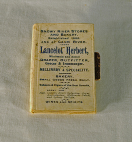
This is a small souvenir or promotional book for Herbert Stores in Orbost and Cann River. Lancelot Herbert came to Orbost in 1886, taking up a partnership with local store-owner George Temple. After Mr Temple’s death in 1891, Lancelot took over the store and progressively developed Herberts Snowy River Stores which grew into a department store of several shops along Nicholson St. He also had small shops at Cann River, Noorinbee and Genoa which were run by members of his family, as well as a carrying business and fuel outlets. Lancelot died on 2/6/1911 and his wife Martha [died 1945] are buried in a joint grave in Orbost Cemetery. (info. Noreen and Lindsay Thomson. More from "In Times Gone By' by Deborah Hall)Associated with a well-known Orbost business which started in 1888 and finally closed in c.1970. A small book with a white/cream cover and black printing. It has three cardboard pages inside which are blank. A pencil holder is attached to the back cover. On front cover: SNOWY RIVER STORES AND BAKERY. Established 1886, AND CANN RIVER. Lancelot Herbert, Wholesale and Retail DRAPER, OUTFITTER, Grocer & Ironmonger, MILLINERY A SPECIALTY. BAKERY, SMALLGOODS FRESH DAILY. Tobacco & Cigars of the Best Brands. AGENT FOR: Age, Leader, Every Saturday, Argus, Australasian, Melbourne Punch, and Sydney Morning Bulletin. WINES AND SPIRITS.souvenir herbert-stores -
 Port of Echuca
Black and white photograph, 1971
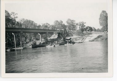
This is a photograph showing the P.S. Alexander Arbuthnot about to be removed from the water to be transported to Shepparton for restoration. The Alexander Arbuthnot was pulled off the bottom of the river at Yielma in July 1972 and taken to Shepparton via Barmah in January 1973.This photograph is significant as it shows the P.S Alexander Arbuthnot about to come out of the river, to be fully restored.A black and white photograph 13 cms X 9 cms of the P.S Alexander Arbuthnot under the Barmah Bridge, prior to being taken out of the river and taken to Shepparton.Written on the back of the photo are the following words. "Alexander Arbuthnot being moved into position under the Barmah Bridge prior to removal from the water and transported to Shepparton for restoration 1971 - 1973. The paddle screamer was previously sunk near the Victorian bank. At Newmans property at Yielma." paddle steamers, ralton, greg, shepparton, p.s alexander arbuthnot, international village shepparton, yielma -
 Warrnambool and District Historical Society Inc.
Plate, The Hopkins Warrnambool
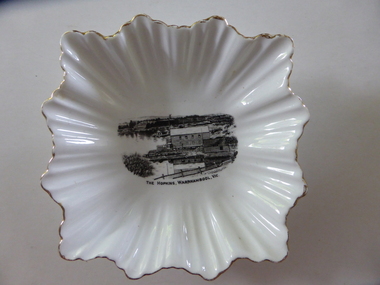
This is a dish sold to tourists visiting Warrnambool in the 1920s as a souvenir of Warrnambool and the Hopkins River. It was made by the Royal Stafford Bone China Company which was founded in the mid 1800s and based in Stoke-on-Trent in Staffordshire, England. The scene depicting the Hopkins River mouth shows the Lyndoch windmill, the Lyndoch bungalow built in the early 1920s by Florence Lake, Proudfoots Boathouse and the Rowing Club building. This dish is an interesting example of the high-quality souvenirs sold to tourists in the mid 1920s. Local Warrnambool residents may also have purchased an item such as this. Souvenir items depicting local scenes are still sold today in most places in Australia.This is a square-shaped white china dish with a fluted edge and gold colouring on the edge of the fluting. In the centre of the dish is a black and white image of the mouth of the Hopkins River near its mouth. On the base is a blue stamp of the maker of the dish. ‘The Hopkins, Warrnambool, Vic.’ ‘Guaranteed Royal Stafford English Bone China, Made in England’ hopkins river, warrnambool, lyndoch, warrnambool, history of warrnambool -
 Port of Echuca
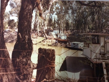
Photograph - Coloured rectangular photograph, 03/04/1984
The P.S Adelaide had been displayed in the Hopwood Gardens from 1960. In 1984 The City of Echuca decided to put the paddle steamer back in the river. This happened over several weeks and involved digging a boat ramp into the bank in front of the Hopwood Gardens. This involved a lot of skill and people. It also attracted a lot of attention. Crowds gathered every day to watch the task. In this photograph the P.S Pevensey in the foreground still has the name P.S Philadelphia writing on its name plate. The P.S Pevensey was used in the TV Series 'All The Rivers Run', as the P.S Philadelphia. Relates to a series of images Reg. nos. P000059.3, P000061.3, P000062.2, P000063.3, P000070.2, P000071.The re-floating of the P.S Adelaide is significant because it occurred at a time when the Tourist Industry was gathering momentum in Echuca. The City of Echuca made the decision to add another paddle steamer to its fleet to carry passengers on the Murray River. The P.S Adelaide is one of the oldest, still operative wooden hulled paddle steamers in the world. It celebrated it's 150th birthday in July 2016. The re-floating of the P.S Adelaide created a lot of attention locally and regionally.A rectangular coloured photograph, and enlargement photograph, of the P.S. Adelaide being re-launched into the Murray River , on the 3rd April, 1984. The photograph is taken from the N.S.W bank with the P.S Pevensey in the foreground right corner of the photograph. The word Philadelphia can be seen faintly on the P.S Pevensey. There is a large crowd of people on the Victorian bank watching. There is a floating pontoon on the river immediately in front of the P.S Adelaide.On near boat obscured are the words Philadelphia.p.s adelaide, p.s pevensey, all the rivers run, p.s philadelphia, hopwood gardens, re-floating of the p.s adelaide. -
 Kew Historical Society Inc
Print, Sands & Kenny, Dights Mill, 1856
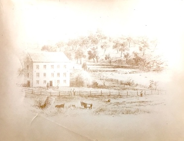
"In 1839 John Dight purchased Melbourne block 88, which included 26 acres of land along the Yarra River for £481 at the Port Phillip land sales held in Sydney. Dight was already in the business of flour milling and had a mill near Campbell Town in New South Wales called ‘Ceres’. In April 1840, he notified his customers through The Sydney Herald that he was leaving to go to Port Phillip. The first steam powered flour mill was constructed in Melbourne in 1841. Dight built his water powered mill, soon after, from bricks bought over from Tasmania. Dight used the river to power his mill: Water flowed along an inlet channel to turn an undershot water wheel. In order to regulate flow or to ensure flow for times when river levels were low, Dight constructed a rough stone weir." (Melbourne Water)Dights Mill. Reproduction of a book plate from an original wood engraving, showing Dights Mill and Falls on the River Yarra. The image was originally published in Sands & Kenny, Melbourne & Sydney.Annotation on reverse: "Dights Flour".dights mill, yarra river -
 Power House Rowing Club
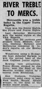
Newspaper clipping, RIVER TREBLE TO MERCS, 1958
RIVER TREBLE TO MERCS -
 Lakes Entrance Historical Society
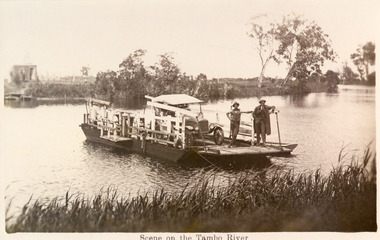
Photograph - Johnsonville Punt, 1930
Also black and white copy 16.5 x 25 donatedBlack and white photograph of a postcard of the punt, two men and early model motor vehicle on punt. Johnsonville, Victoria.Scene on the Tambo River waterways, transport -
![Photograph - Construction of the F19 [Eastern Freeway], Ron Setford, May 1976](/media/collectors/550653872162f11fb04854aa/items/68287c9964071e7c58e66ab5/item-media/68287cbb64071e7c58e66c8f/item-fit-380x285.jpg) Kew Historical Society Inc
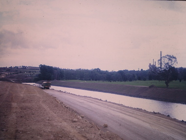
Kew Historical Society IncPhotograph - Construction of the F19 [Eastern Freeway], Ron Setford, May 1976
Ron Setford and his wife Grace Setford lived in Tanner Avenue, East Kew, from c.1946 to c.1995. A keen photographer, he recorded the changing face of Kew over a 20 year period. Apart from 30 photographs of built structures and places in Kew dating from 1960 and 1961, 145 of his 35mm colour slides chronicle the development of the F19 (later renamed Eastern) Freeway through the Yarra Valley in Kew over a five year period from c.1972 to c.1977. This important collection was donated to the Society by his granddaughter in 2025.This collection of 175 35mm slides is of local and statewide significance, owing to its subject matter, particularly the major development of road transport infrastructure during the 1970s with the construction of the Eastern Freeway. The photographer also took care to annotate and date most of his slides which enable the researcher to pinpoint temporal and spatial locations."Yarra River & Lagoon"ron setford, eastern freeway, f19 freeway -
 Lakes Entrance Historical Society
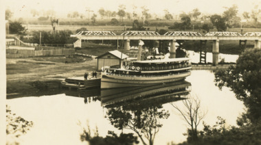
Postcard - S.S. Gippsland, 1932 c
Message on back from Ada Grant wife of Edward Grant of MetungBlack and white postcard showing SS Gippsland moored at Bairnsdale wharf. Rail bridge and road bridge in background behind office warehouse Bairnsdale VictoriaMitchell River Bairnsdaleships and shipping, correspondence -
 Kew Historical Society Inc
Photograph - Construction of the Eastern Freeway (F19), Ron Setford, November 1972
Ron Setford and his wife Grace Setford lived in Tanner Avenue, East Kew, from c.1946 to c.1995. A keen photographer, he recorded the changing face of Kew over a 20 year period. Apart from 30 photographs of built structures and places in Kew dating from 1960 and 1961, 145 of his 35mm colour slides chronicle the development of the F19 (later renamed Eastern) Freeway through the Yarra Valley in Kew over a five year period from c.1972 to c.1977. This important collection was donated to the Society by his granddaughter in 2025.This collection of 175 35mm slides is of local and statewide significance, owing to its subject matter, particularly the major development of road transport infrastructure during the 1970s with the construction of the Eastern Freeway. The photographer also took care to annotate and date most of his slides which enable the researcher to pinpoint temporal and spatial locations."New river course / Latrobe golf club across river / Nov 72"ron setford, eastern freeway, f19 freeway -
 City of Warrnambool Rowing Club
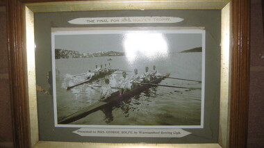
Photograph, The Final for Mrs Rolfe's Trophy
Mrs George Rolfe was the wife of the owner of Lyndoch. He was a Melbourne tea merchant, who owned 216 acres of the Shipley estate further up the Hopkins River. In the late 1870s he bought 2 acres of land and house along the Hopkins near the bridge and developed into Lyndoch. By 1883 he increased to 50 acres. He resoiled the land, put in a water supply reservoir, water tanks and pumps, a reticulation system and a windmill- 50 feet high with four sails 18 feet high and 4 1/2 wide. George Rolfe died in 1919 and the present Lyndoch House was built in 1925. Source: By These We Flourish, A History of Warrnambool by C.E. Sayers and P.L. Yule Edition 1 A4 landscape black and white photograph of a mens rowing four on the Hopkins River, Warrnambool.The Final for Mrs Rolfe's Trophy Presented by Mrs George Rolfe by W.R.C.lyndoch, lyndoch warrnambool, city of warrnambool rowing club, warrnambool rowing club, george rolfe -
 Sunbury Family History and Heritage Society Inc.
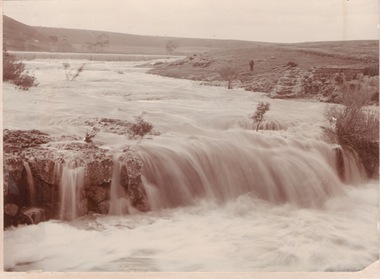
Photograph
The waterfalls were on the Jacksons Creek downstream from Sunbury township and in the vicinity of a mill which was built on the river bank. The man standing on the riverbank on the RHS of the image is near the remains of Eadie's Mill which was one of the early structures erected in Sunbury.A sepia photograph mounted on a cream board of two waterfalls in a flooded river with bare hills on either side. A man is standing near some stone ruins on the RHS of the image.waterfalls, jacksons creek, mill falls -
 Marysville & District Historical Society
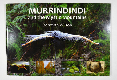
Book, Donovan Wilson, Murrindindi and the Mystic Mountains, Post 2009
... rivers ...A book of photographs of natural attractions, flora and fauna taken in and around the Murrindindi Shire.Paperback. Front cover has a large photograph of a lyrebird in full song. Along the lower edge of the front cover are four photographs; a Spotted March frog, the Gould Memorial Drive, a river and a wombat. Back cover has a photograph of the Cathedral Range at dawn.non-fictionA book of photographs of natural attractions, flora and fauna taken in and around the Murrindindi Shire.murrindindi, victoria, landmarks, flora, fauna, waterfalls, rivers, nature, natural attractions -
 Marysville & District Historical Society
Book, Donovan Wilson, Murrindindi and the Mystic Mountains, Post 2009
... rivers ...A book of photographs of natural attractions, flora and fauna taken in and around the Murrindindi Shire.Paperback. Front cover has a large photograph of a lyrebird in full song. Along the lower edge of the front cover are four photographs; a Spotted March frog, the Gould Memorial Drive, a river and a wombat. Back cover has a photograph of the Cathedral Range at dawn.non-fictionA book of photographs of natural attractions, flora and fauna taken in and around the Murrindindi Shire.murrindindi, victoria, landmarks, flora, fauna, waterfalls, rivers, nature, natural attractions -
 Kew Historical Society Inc
Photograph, Floods in North Kew, 1971
Living with natural processes was frequently a challenge to early European settlers and later residents of what was in the 1850s administered by the Borondara Road Board. This was compounded by the area being bounded on three sides by rivers (Yarra River, Koonung Creek and Gardiner's Creek). In 1849, the historian James Bonwick recorded that "our district [Kew] suffered considerably. Mr Wade speaks of 80 acres, out of 100 acres of his cultivated paddock, covered by water." Newspapers continued to describe major flooding in Kew in 1863, 1869, 1878, 1880, 1889, 1891, 1916 and 1934. While the construction of the Upper Yarra dam in 1957 reduced the levels of flowing downstream, local and riverine floods continue.The Kew Historical Society's pictures and map collections testify to the impact of flooding in the district. They have historical importance in documenting the extent of flooding in the district and its affects on homes, services and recreation. Numerous photographs record flooding throughout the Twentieth Century.Floods in North Kew, 1971. Looking northeast towards Kilby Road from River Avenue. Annotation on reverse: map and date "8 Nov. 71 10.30am".floods (kew), yarra river, kew flood, kilby road flood -
 Warrnambool and District Historical Society Inc.
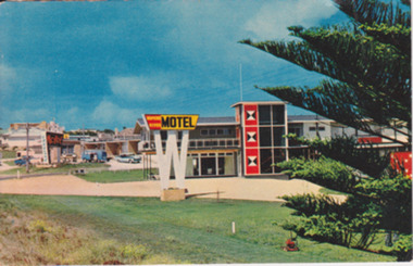
Postcard - Post Card Warrnambool Motels, Circa 1960’s
These two motels were built in the 1960’s on the eastern outskirts of Warrnambool on the corner of the old Princes Highway and Simpson St. They were both built around 1960. The Turn In was originally known as Freeland’s Turn In. The Hopkins River, later the Riverside Motel, was demolished in around 2000. This photograph provides a view of Warrnambool as it was beginning the expansion on the East side of Warrnambool. The buildings depicted are very typical of the style of buildings of the 1960.s Coloured photograph postcard depicting the Hopkins River Motel. Large red and yellow sign mounted on top of a white ‘W’ Part of Norfolk pine. The back is unused. Nucolorvue productions Pty Ltd. W4. Printed in Australia. Printed in Australia. warrnambool, freeland’s turn in, hopkins river motel, turn in motel, warrnambool motels -
 Orbost & District Historical Society
plastic bag, mid-second half 20th century
This was used by Snowy River Dry Cleaners. Snowy River Dry Cleaners was situated in Stanley Street, Orbost (previously a hat factory). There was also a shop in the CBD of Orbost. Basil Dowie moved his dry cleaning business from Nicholson Street to 31 Stanley Street where Stuart Hats had been. He had originally bought the business from Laurie Harrington in August 1950. (more information in Orbost & District Historical Society Newsletter No. 138 - John Phillips)This item is from a business which no longer exists in Orbost.A clear rectangular shaped plastic bag with red print inside a red frame - : Snowy River Dry Cleaners Orbost Moth Proof Storage Bag Service". It has a logo for FlexPak on an outline of Australia. snowy-river-dry-cleaners -
 Kew Historical Society Inc
Photograph - Yarra Valley Floods: Kew East, 1916
Flooding of the Yarra Valley, including that section of the Yarra bordering Kew and Kew East in the north and west of the municipality, was a regular occurrence. Extreme flood events of the Yarra River are recorded to have occurred in 1891, 1901, 1916, 1923 and 1934. The Municipality of Kew's response to these floods was to enact planning decisions restricting residential development in flood prone areas following the floods of 1916, 1921 and 1934. While floods continued after the development of the Upper Yarra Reservoir (construction 1948-57), the regularity and extent of these inundations diminished. During the nineteenth century, the land abutting the south side of the Yarra in Kew was devoted to dairy farming. In the twentieth century, before and after the construction of the Eastern Freeway, much of this low-lying area was used as golf courses and public parks.One of a collection of photographs of flooding in the Kew section of the Yarra Valley which are in important research resource for the location and extent of flooding in the first half of the twentieth century. Flooding of the Yarra Valley at East Kew in 1916. The view is taken from a street (maybe Birdwood Avenue) intersecting with Kilby Road looking northeast across the flood waters to Ivanhoe and Heidelberg. The extensive flooded area shown in the photograph would have included remnant dairy farms and the Kew Golf Club. Verso: "Floods / Yarra River / East Kew / Kilby Road / 1917? / 87"yarra river, yarra valley, floods -- kew, kilby road -- kew (vic.), kew golf club -
 Orbost & District Historical Society
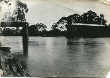
black and white photograph, January 1934
Damage estimated at £500,000 was caused by the 1934 floods in the Orbost district. This 1934 flood was devastating, destroying a section of the 1922 Orbost bridge, wrecking fences, bridges and roads, dumping silt and debris on the rich river flats and drowning cattle. The centre span of the Orbost Bridge was washed away. This item is a pictorial record of the 1934 floods, a significant part of Orbost's history.A black / white photograph showing the flood damage to the Snowy River Bridge. There is a gap in the bridge where the centre span has been washed away. In the background is a punt.orbost-floods-1934 natural-disasters-floods snowy-river-bridge -
 Port of Echuca
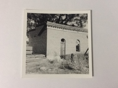
Black and white photograph, Approx. 1975
The old brick office buildings of the Murray River Sawmills were demolished around 1975. This photo relates to the series P000105-P000107. Sawmills in the Echuca area were historically and socially significant being a large employer in the area. The Murray River sawmill was one of the biggest and longest operating sawmills in the area. Black and white photograph of the old Murray River Sawmills, showing rear and side of the building with doorway and window. Lumber is piled at left front of photograph and other material (wire?) has been dumped in front of and along the side of the building.On reverse, in pencil, " M. R. Sawmills office or other old building, demolished". In pen "c.1975". Printed "Kodak paper". Blue ink"0932"murray river sawmills, echuca, echuca, victoria, pullicino, j -
 Warrnambool and District Historical Society Inc.
Map - An Angler's map of the Hopkins River Estuary, Angler's map Hopkins River, 1980s
This is a map of the Hopkins River Estuary prepared by Dr John Sherwood for the benefit of anglers. The information on the sheet includes the location of sand banks, the water depths, boat ramp facilities and public access facilities. Some of the information has been gathered from aerial photographs. The map has been produced by the Warrnambool Institute of Advanced Education which was developed in the late 1960s from the tertiary section of the Warrnambool Technical College and with all its departments established by 1984 at the Sherwood Campus five kilometres from Warrnambool on the Princes Highway. Today the site is occupied by Deakin University, Warrnambool campus. The Warrnambool Anglers’ Club has its headquarters on the banks of the Hopkins River near the mouth of the river and the Lyndoch Aged Care facility.This map is of interest as a specialist one, providing fishermen with detailed information on all aspects of the Hopkins river estuary. Fishing has been both a profession and a popular recreational pursuit for Warrnambool residents since the early days of the city’s settlement. The Hopkins River Estuary has been a focal point for fishermen throughout Warrnambool’s history. This is a sheet of paper folded three times to produce a folded map. The front cover has a black and white photograph of two fishermen with a large fish. The map of the Hopkins River Estuary is in yellow, blue and black and covers the side of one sheet and three quarters of the other side. There is an advertisement for the Hopkins River Boathouse with a black and white sketch of the boathouse and notes on the map written by Dr John Sherwood. There are several diagrams showing the water depths. The map has some silverfish damage and some tearing at the folds. warrnambool anglers’ club, history of warrnambool, hopkins river, hopkins river estuary, john sherwood -
 Clunes Museum
Artwork, other - PLATE, RICHARD FORD
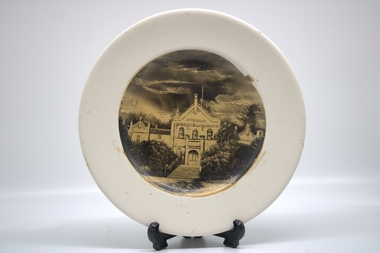
.1 PAINTING OF ORIGINAL CRESWICK HOSPITAL SKETCHED ON CERAMIC PLATE, THEN VARNISHED .2 PAINTING OF MOUNTAINS, RIVER AND COTTAGE SKETCHED ON CERAMIC PLATE, THEN VARNISHED.1 CREAM COLOURED CERAMIC CIRCULAR PLATE, SKETCH OF ORIGINAL CRESWICK HOSPITAL. IMAGE SKETCHED INTO CANDLE SMOKE .2 CREAM COLOURED CIRCULAR PLATE, SKETCH OF MOUNTAIN AND RIVER SCENE. IMAGE SKETCHED INTO CANDLE SMOKER FORDrichard ford, local history -
 Port of Echuca
Black and white photograph, approx 1980
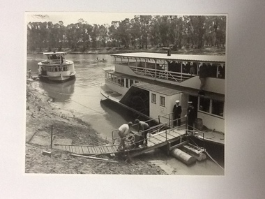
Black and white photograph of 2 steamers moored by the river bank. The foreground steamer has 2 crew dressed in sailors uniform (band members?) There is a person standing on the lower roof section putting a case (?) into the upper floor with quite a few people up there also. There appears to be musical instruments behind the crowd. On the gangplank 2 men are wheeling a piece of equipment onto the steamer. The background steamer is the P. S. Canberra, also moored to the bank and unloading. There is a row boat in the middle of the river with 4 rowers and a standing cox.This appears to be a navel band getting ready for a cruise on the river, a social event that often happens in the Echuca area. On the other side of the river can be seen a "Caltex" sign and a couple of caravans parked between the trees. This could have been part of a river festival.Black and white photograph of 2 steamers moored by the river bank. The background steamer is the P. S. Canberra. The foreground steamer has crew dressed in sailors' uniforms (band members?). There is a person standing on the lower roof section putting a case (?) into the upper floor with quite a few people up there also. There appears to be musical instruments behind the crowd. On the gangplank 2 men are wheeling a piece of equipment onto the steamer. There is a row boat in the middle of the river with 4 rowers and a standing cox.The steamer in the background is marked "Canberra". In pencil on the back is marked P000102.paddle steamers, p.s.canberra -
 Tatura Irrigation & Wartime Camps Museum
Photograph, Stuart Murray Canal Sign, 1890s
Taken by photographer for State Rivers and Water Supply Commission.Medium sized black and white photograph. Sign:-"STATE RIVERS AND WATER SUPPLY COMMISSION/GOULBURN IRRIGATION SYSTEM/STUART MURRAY CANAL/CONVEYS WATER FROM GOULBURN WEIR TO WARANGA RESERVOIR/DESIGNED AND CONSTRUCTED BY VICTORIAN WATER SUPPLY DEPARTMENT - 1981./STUART MURRAY M.I.C.E CHIEF ENGINEER."goulburn weir, victorian state rivers and supply commission -
 Marysville & District Historical Society
Postcard (item) - Colour postcard, Nicholas John Caire, Scene Watt's River, Fernshaw, 1858-1918
One of a series of postcards of photographs taken by socialite photographer Nicholas John Caire. N.J. Caire had a great love for the area and in the late 1800's took many photographs of Marysville and its surrounds.One of a series of postcards of photographs taken by socialite photographer Nicholas John Caire. N.J. Caire had a great love for the area in and surrounding Marysville and in the late 1800's took many photographs of Marysville and its surrounds. N.J. Caire was born in 1837 in Guernsey. He arrived in Adelaide about 1860 along with his parents who encouraged his early interest in photography. He opened a studio in Adelaide in 1867 after traveling extensively throughout the Gippsland taking photographs. After marrying in 1870 he moved to Talbot in Victoria until 1876 when he opened a studio in the Royal Arcade in Melbourne. After 1885 N.J. Caire gave up his city work and made his home in South Yarra and devoted the rest of his life to outdoor photography, specializing in the bush, the gullies and the mountains of south-eastern Victoria. POST CARD This Space may be used for Correspondence (FOR ADDRESS ONLY) Orange one penny postage stamp with an image depicting Queen Victoria Date stamp/ 8.3.06/ 4AM/ MELBOURNE/ 14 7.3.06 My Dear Em/ I received your kind/ note and will be very pleased/ to go out & see you tomorrow/ but cannot say what/ train I will catch as/ I do not know how/ they run. I will try/ not to miss the train/ though. I heard Vic was/ down will be glad to see/ her love to you both/ Yours in health Mary. Mrs Tribeau/ "Hazel Dell"/ Connell Street/ Hawthornwatt's river, fernshaw, victoria, nicholas john caire, postcard, souvenir -
Port Melbourne Historical & Preservation Society
Map - Yarra River, Saltwater River and Coode's Canal, 1935
Plan No.7. Yarra River, Saltwater River, Coode's Canal area 1935.Signed Walker A.W.melbourne, a w walker, melbourne and metropolitan board of works, mmbw -
 Warrnambool and District Historical Society Inc.
Plate, Mouth of the Hopkins, c.1920
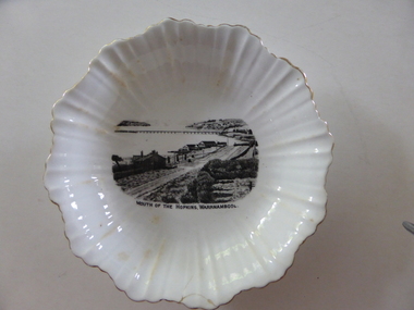
This is a dish made by the English company of Royal Stafford Bone China about 1920 and sold in Warrnambool as a souvenir of the city with an image of the scene at the mouth of the Hopkins River. The scene depicted shows the old Hopkins Hotel, Proudfoots Boathouse, Lyndoch and the Hopkins River Bridge. This dish is of some interest as an example of the type of high quality souvenir offered to local tourists in the early 20th century. It is historically interesting as it depicts the Hopkins River mouth about 1920 and there have been many changes since then.This is a white oval dish with fluting on the sides and fluted edges. The rim of the fluting is outlined in gold. On the inside base of the dish is a black and white image of the mouth of the Hopkins River. There are brown stains on part of the fluted material and the outside base has the maker’s shield and name. There is a small crack on the edge of the dish.‘Guaranteed Royal Stafford English Bone China Made in England.’ history of warrnambool -
 Orbost & District Historical Society
printer's block, 1920's
This printer's block was used by the Snowy River Mail in the 1920's. This block is an advertisement for Tomlinson and McFarlane Bros, Drapers and General Merchants of Nicholson Street, Orbost.Since 1890 the Snowy River Mail has been the local newspaper of the Orbost district.This local paper has been the means by which readers in Orbost were able to learn about newsworthy events and issues in their local community for over a century.A printer's block from the Snowy River Mail. It is an advertisement for ladies' wear in the 1920's. It is an ad for Tomlinson and McFarlane Bros.of Nicholson Street Orbost and advertises fashionable contour corsets. The plate is nailed onto a block of chipboard.printing newspaper media advertisement tomlinson-and-mcfarlane-bros