Showing 1520 items matching " sand"
-
 Bright & District Historical Society operating the Bright Museum
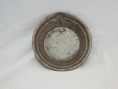
Pan gold
Gold pans were used to separate gold flakes or particles from alluvial deposits by washing and discarding sand, gravel and the like. This pan is very small and may have been produced for demonstration or display purposes.Gold pans had widespread use wherever alluvial deposits were found an d water was available.Gold Pan. Smal size, as to have been galvanised. Diameter 240mmgold, gold pan, goldfields -
 Bright & District Historical Society operating the Bright Museum
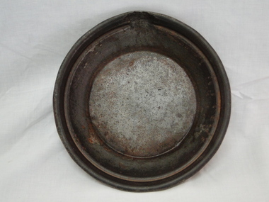
Pan gold
Gold pans were widely used in alluvial gold fields for seperating particles or flakes of gold from gravel, sand and the like. This one is small and may have been used for demonstration only or for display purposes.Gold pans had widespread use in alluvial gold fields where water is available.Gold Pan, small. Diameter 240mm.gold, gold pan, goldfields -
 Lakes Entrance Historical Society
Photograph - Lake Bunga, M Holding, 1/06/1998 12:00:00 AM
Also a second coloured photograph showing expanse of sand on western shore with Mrs Glad Scarce seated on fence looking at open entrance Lake Bunga number 03849.1 size 10 x 15 cmColour photograph of the open entrance after an unusual weather condition Lake Bunga Victoriawaterways, lake bunga -
 The 69 Collective
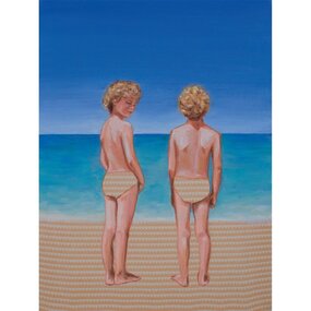
Painting, Leah Mariani, Beach bums, 2013
This artwork is part of 69Fifteen, the book published in 2013 celebrating 69 Smith Street Gallery’s 15th year in operation as an artist-run space.Oil on cotton fabric. Image of two young boys standing beside each other looking out to sea. They are painted against a background of blue-green water and a clear blue sky. The pattern on the sand is repeated in the boys' swimming costumes. One of the boys has his head turned away from the water.leah mariani, 69 smith street gallery, artist-run initiative, artist-run space, melbourne art galleries, painting, www.leahmariani.com -
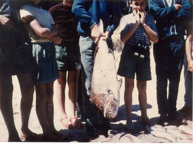 Southern Sherbrooke Historical Society Inc.
Photograph
Colour photograph of a group of people after having caught a snapper at Rosebud in 1960. Seven people are standing in a row on the sand with one of them holding the snapper that's almost as long as their legs. A boy on the right has his hands to his mouth, whilst everyone else's heads have been cropped off. -
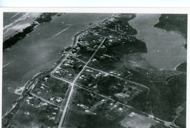 Lakes Entrance Historical Society
Photograph - Lakes Entrance, Bulmer H D, 1940c
Black and white photograph of aerial view of township. It shows route of Princes Highway through town, turning north at Myer Street and continuing along Roadknight Street. Few jetties on North Arm, many on Cunninghame Arm. In far upper left of image sea is breaking on sand hummocks. Lakes Entrance Victoriawaterways, township -
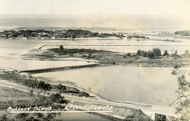 Lakes Entrance Historical Society
Postcard - Bullock Island, Bulmer H D, 1945
Black and white postcard of Bullock Island, Lakes Entrance, showing an extensive rock groyne to the south of the island, into which dredged sand and spoil is to be placed in order to extend the island's area. North Arm bridge, Bullock Island footbridge, New Works settlement and Entrance channel also in image. Lakes Entrance VictoriaBullock Island, Lakes Entranceboats and boating, fishing industry, islands -
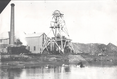 Bendigo Historical Society Inc.
Photograph - FORTUNA COLLECTION: HUSTLERS AND ENERGETIC MINE
Black and white photograph of mine site. Metal poppet head in centre, engine room buildings on LH side. Brick chimney extreme left. Large mullock/sand heap on RH side. Mine dam in foreground, three geese floating in water. In front of poppet head, horse drawn wooden cartbendigo, mining, hercules and energetic mine -
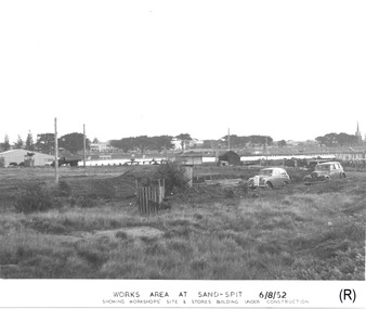 Glenelg Shire Council Cultural Collection
Photograph - Photograph - Portland Harbour Trust - Works area at Sand-spit, 6.8.52, 1952
Port of Portland Authority archivesFront: WORKS AREA AT SAND-SPIT. 6/8/52/ SHOWING WORKSHOPS' SITE & STORES BUILDING UNDER CONSTRUCTION (lower centre) Back: P.H.T./ Print No. 3/3 Neg. No // Date taken 6-8-52./ SUBJECT./ % (Ink stamp with blue pen and pencil additions, centre)port of portland archives -
 Eltham District Historical Society Inc
Map (item) - Sales Brochure, Plenty Township Estate and Bryn Teg Hill's Estate, Coghill & Haughton, Melbourne, c.1924
Plenty Township Estate "The rapid growth of Greensborough and the great traffic development on the main road between Heidelberg and Eltham augurs well for Plenty Township Estate. Already a Store, Post Office and State School have been started, and the activities of the Local Progress Association will help the district forward considerably. Within walking distance of the Montmorency and Greensborough stations." Bryn Teg Hill's Estate "Better known as "The Old Sand Hill, "within walking distance of the Montmorency and Greensborough railways stations." "Some few years back Mrs Thomas subdivided portion of the Sand Hill Paddocks, and the areas sold have been settled and many converted into charming outer suburban garden homes with cultivation and orchard plots. The south-eastern slope gives the land a grand outlook over the Yarra Valley on to the Dandenoings, and the are is very picturesque and homely." "A number of the blocks contain large deposits of valuable building sand, which should prove good speculation in view of the forecast for further rapid home development along the Eltham Suburban Electric Service." Sand Hills Road (Old Eltham Road) Date estimated as c.1924 - Electricification of railway line to Eltham referenced on map occured April 1923 and Mrs Mary Thomas died August 1925. Her home Bryn Teg became part of the Heidelberg Golf Club in 1927.The establishment of Lower Plenty as a suburban growth area supported by easy commuting facilitated by the elctrification of the Eltham railway linebonds road, bridge, bryn teg hill's estate, coghill & haughton, eltham road, heidelberg golf club hotel, houses, lower plenty, lower plenty bridge, lower plenty road, main road, plenty hotel, plenty river, plenty township estate, real estate agent, sales brochure, sand hills road, the old sand hill, sand hill paddocks, woodfull road, old eltham road, bryn teg, mrs m thomas -
 4th/19th Prince of Wales's Light Horse Regiment Unit History Room
Field Sketch, From General Chaytor's HQ After the battle of Bir El Abd, c 1917
A field sketch by Sgt Otho Hewett looking North toward Bir El Abd (a well near Arish). The country depicted is a vast area of sand dunes, with the only named features being the Canterbury MR Graves, Bir El Abd (a well), graves, Hod el Zawara and Old Turk telegraph line.field sketch, bir el abd -
 Bendigo Historical Society Inc.
Photograph - IRONBARK MINE, NEW CHUM REEF, BENDIGO, 1930 ?
black and white photo: collapsed wooden poppet head of the Ironbark Mine, four men on the left hand side., with engine holding down bolts in the right foreground. 'Old Ironbark, New Chum Reef ?' 26.11.1999 Previous mng 39 In pen - Ironbark legs looking from the tram track and sand heap behind it.organization, business, ironbark mine -
 Lakes Entrance Historical Society
Photograph - Safeway Supermarket, Holding M, 1994
Date made May 1994Colour photograph of the old Carnival site, Esplanade, showing preliminary work on site of Safeway Supermarket. Pile of sand and soil, tip truck and pile of large diameter pipes on site. Five people on footpath beside highway which has tiled traffic island division. Township houses in the background. Lakes Entrance Victoriatownship, transport, retail trade -
 Lakes Entrance Historical Society
Photograph - Butcher's Paddock, Hanlon, Vera, 1940c
Historic home at 90 Captenter St 'Corrumbene' is pictured on right hand side of photograph. Godsell's house opposite on Western side of North ArmBlack and white photograph showing view of lower reaches of North Arm, part of town, Cunninghame Arm and sand dunes in background, and North Arm on right. Photo taken from Allens Hill, Myer St, vacant paddocks in foreground, known as Butcher's Paddock, slaughterhouse and buildings in mid view. Lakes Entrance Victoriatownship, waterways, animals -
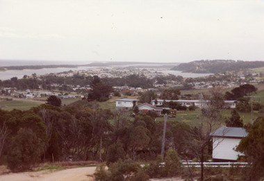 Lakes Entrance Historical Society
Photograph - Township
Colour photograph of township of Lakes Entrance showing North Arm, North Arm Bridge, Jemmys Point, Mount Barclay, Kalimna Heights, Cunningham Arm and sand dunes on left. Looking west to Bullock Island and Rigby Island. Photo taken from near Telecom Tower on Merrangbaur Hill. Lakes Entrance Victoria bridges, waterways, islands, township -
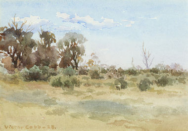 Bayside Gallery - Bayside City Council Art & Heritage Collection
Work on paper, Victor Cobb, Evening Hampton, 1923
watercolourhampton, evening, beach, foreshore, landscape, victor cobb, coast, bayside, sand, shrub, tree -
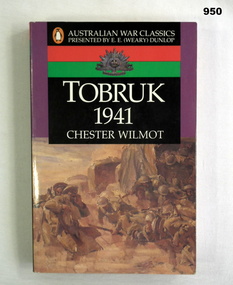 Bendigo Military Museum
Book, Chester Wilmot, Tobruk 1941, 1993
Book is part of the Australian War Classics series presented by E E (Weary) Dunlop. Author documents the story of the fighting in & around Tobruk from January to December 1941.Book, soft cover, cardboard, white colour print on front, back & spine, cover illustrations - Troops debussing in a sand storm, Libya by Ivor Hele, purple, black, red & green colour background. Rising Sun badge on front & back covers, 348 cut plain pages, illustrated black & white coloured maps.Handwritten in blue colour ink on front flyleaf: F Fuller In black ink on front title page & page 348 - RSL Stampbooks, military history -
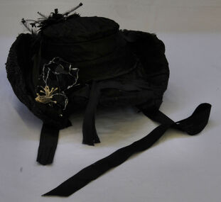 Orbost & District Historical Society
hat
Lady's black bonnet made of silk. Edges (sides) tilt upwards and the front is peaked. Black flowers, ribbon and feathers are displayed at the back and plastic and wire black flowers with white stamens at the front Two long pieces of ribbon fall at sides to tie under chin. Sequins at the R.H. sand. Whole hat is a wire structure.hat costume-female headwear -
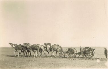 Bendigo Historical Society Inc.
Postcard - ACC LOCK COLLECTION: B&W PHOTO OF A 6 CAMEL TEAM WITH A GUN CARRIAGE, POSTCARD, 1914-1918
Postcard, WW1, B&W photo of a 6 camel team pulling a gun carriage in a desert landscape. A soldier walking behind the gun carriage and an officer standing at right. Handwritten in ink on the back - Testing Rdrail attachment (10 wheels) in loose sand. Zeitoun Jany'16. (Zeitoun is the NZ army training camp near Cairo)postcard, postcard, ww1, egypt, zeitoun, camels -
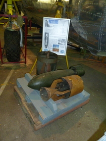 B-24 Liberator Memorial Restoration Australia Inc
WWII Practice Bombs
Practice bombs could be service bombs, inert loaded with sand, water for chalk/lime solution. Standard practice bombs were painted white overall with two light green bands painted around centre of the tail. Inert service bombs painted black and those containing an exploder had a red band around the body.a14 -
Tatura Irrigation & Wartime Camps Museum
Book - text, Internees at camp 1 Tatura, 1942
Text book on navigation compiled in Camp 1 Tatura by interneesHard sand coloured covered stitched text book of 208 pages. Separate dust cover and errata section/insert. Dust cover has hand painted illustration on front of sea/sky landscape, Ship, compass like star and title at top. Errata. Consists of 2 single sheets folded forming 8 pages.as abovekeuchenmeeister, fleth -
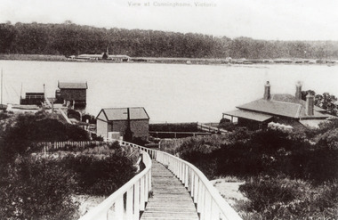 Lakes Entrance Historical Society
Photograph - New Works, 1910c
Also black and white copy 12.5 x 18 cm with smear of purple ink in top left hand corner, purchased from Helen ClothierTinted black and white photograph showing boardwalk from New Works Jetty over the sand dunes with small shed on jetty, small one room Boole Poole school on right of boardwalk and harbour master's house on right. Club Hotel on opposite foreshore and town on far right. Kalimna escarpment in background, at Lakes Entrance, Victoria.View of Cunninghame Victoriaboardwalk, waterways, ships and shipping, township, topography -
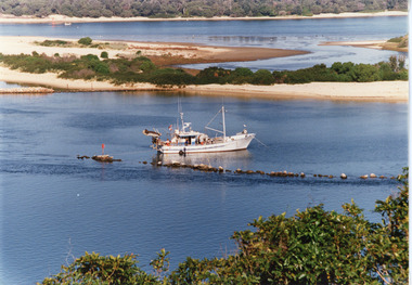 Lakes Entrance Historical Society
Photograph - Dredging, Tambo Shire, 1990c
Second copyColour photograph of the south eastern shore of Rigby Island, Gippsland Lakes. It shows the scrub covered hummocks in the background, Hopetoun Channel, dumped sand which connects Snake Island and Rigby Islands, groynes into Narrows from Rigby Island. Fishing boat with scallop dredge moored in sheltered bay inside a groyne. Lakes Entrance Victoria waterways, topography, fishing industry, dredging -
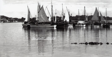 Lakes Entrance Historical Society
Photograph - Western Harbour, Bulmer H D, 1940c
Black and white photograph of the western harbour. It shows a variety of vessels, including auxilliary yachts and motor launches. In the background, part of the New Works area on the south shore includes Signal Flagstaff, Harbour Engineers House and Pilots House. In foreground part of rock groyne built originally to control sand buildup. Lakes Entrance VictoriaThe Boat Haventownship, waterfront, boats and boating -
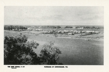 Lakes Entrance Historical Society
Postcard - Township, Rose Series, 1910c
Plus black and white enlarged copy 15x25Black and white postcard. It shows the rear view of the buildings which front the Cunninghame Arm, or Reeves River, one cottage and three jetties on North Arm, sand hummocks of South shore of Cunninghame Arm and Bass Strait in background. Double storied Kelvin House, later Maranui and Methodist Church identified. Lakes Entrance VictoriaPanorama of Cunninghame Victopography, waterfront, township -
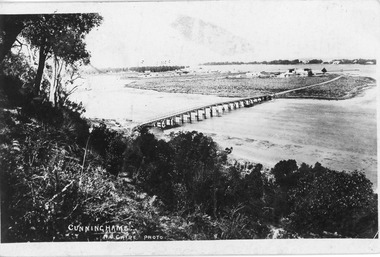 Lakes Entrance Historical Society
Postcard - North Arm, Lakes Entrance Victoria c1898, 1898 c
Black and white postcard of wooden bridge across the North Arm, showing sand hummocks Cunninghame Arm, Club Hotel, and die back of melaleuca on mudflats, caused by salination of Lakes after artificial entrance opened 1889. Vegetation on Kalimna Hill in foreground. Steamer on Cunninghame Arm centre top of photo. Lakes Entrance VictoriaCunninghame N Cairebridges, topography, township -
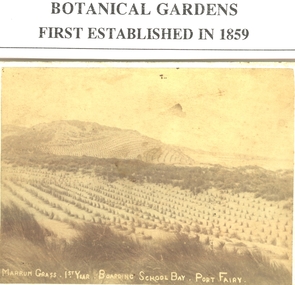 Port Fairy Historical Society Museum and Archives
Photograph, 1884
Marram grass (1st year) South Beach about 1884 planted to stop the erosion of the sand dunes having been stripped of all the tea tree and native grass cover, the tea tree bark being used for tanning leatherBlack and white Photograph of the dunes above Boarding School Bay sewn with Marram grass Marram grass (1st year) South Beach about 1884marram grass, south beach, agriculture, dunes -
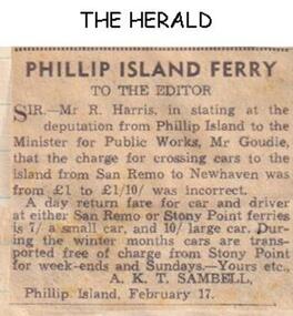 Phillip Island and District Historical Society Inc.
Newspaper clippings
Letter to newspaper indication Ferry Fares on Sand Remo and Stony Point runs. 7/- small car, 10/- large car, cars transported free in winter. Correcting statement made in a previous newspaper report that cost for a car was £1.30/-Letter to newspaper indicating Ferry fares at Phillip Island.local history, documents, newspapers, phillip island, ferries, san remo, stony point, black & white newspaper clipping, ferry fares, san remo to stony point -
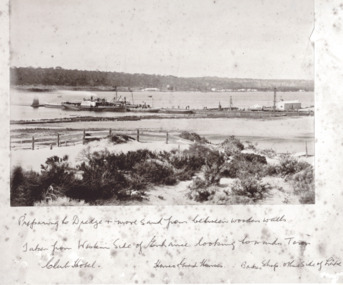 Lakes Entrance Historical Society
Photograph - New Works Jetty, Brooks Photographic Union, 1885 cm
Written under photograph ' Preparing to dredge and move sand from between wooden walls. Taken from Western side of Entrance looking towards Town Club Hotel, Homes Guest House Bakers shop other side of LakesBlack and white photograph of boat loads of tourists moored at New Works Jetty during the construction of the man made entrance at Lakes Entrance Victoriapublic works, jetties, tourism -
Australian National Surfing Museum
Video Clip, Torquay Surf Beach Family Movies, Circa 1947
This home movie features people enjoying summer by the beach. It was filmed at Torquay Surf Beach, Torquay, Victoria circa 1947. The last shots of the film show a surfer riding a hollow wooden plywood surfboard to the beach and stepping off onto the sand.Torquay Surf Beach was a macca for surfers in post-war Victoria. This is one of the earliest movies to show surfing at Torquay and in Victoria. It also features very early images of the Torquay Surf Life Saving Club which is the oldest in Victoria.Black and white 8mm home movie transferred to VHS and digitised to AVI file. Duration - 1 minute and 16 seconds.Museum logo at the start of the video clip.surfing, torquay surf life saving club, 1947, torquay surf beach, hollow plywood surfboard