Showing 5612 items matching " suburbs"
-
 Eltham District Historical Society Inc
Slide, Quinn Estate, Quinn Way, Montmorency, 15 Sep. 1982
One of a series of images of roads and infrastructure taken by Eltham Shire Council Planning and Engineering officers of the Quinn Estate in Montmorency, Stage 1, Private Street Scheme during construction, September 1982. They provide perspective of the changes in housing styles and road development that began sweeping in from the mid 1970s with increasing urbanisation of what was once more outlying suburbs and regions.35 mm colour positive transparency (1 of15) Mount - Kodak Kodachrome CardProcessed 15 Sep1980housing estate, infrastructure, montmorency, quinn estate, roads, sackville street, private street scheme, quinn way -
 Eltham District Historical Society Inc
Slide, Quinn Estate, Cressy Street, Montmorency, 15 Sep. 1982
One of a series of images of roads and infrastructure taken by Eltham Shire Council Planning and Engineering officers of the Quinn Estate in Montmorency, Stage 1, Private Street Scheme during construction, September 1982. They provide perspective of the changes in housing styles and road development that began sweeping in from the mid 1970s with increasing urbanisation of what was once more outlying suburbs and regions.35 mm colour positive transparency (1 of15) Mount - Kodak Kodachrome CardProcessed 15 Sep1980housing estate, infrastructure, montmorency, quinn estate, roads, private street scheme, cressy street, nicholas lauder real estate -
 Eltham District Historical Society Inc
Slide, Quinn Estate, Reichelt Avenue, Montmorency, 15 Sep. 1982
One of a series of images of roads and infrastructure taken by Eltham Shire Council Planning and Engineering officers of the Quinn Estate in Montmorency, Stage 1, Private Street Scheme during construction, September 1982. They provide perspective of the changes in housing styles and road development that began sweeping in from the mid 1970s with increasing urbanisation of what was once more outlying suburbs and regions.35 mm colour positive transparency (1 of15) Mount - Kodak Kodachrome CardProcessed 15 Sep1980housing estate, infrastructure, montmorency, quinn estate, roads, private street scheme, mccarthy grove, reichelt avenue -
 Eltham District Historical Society Inc
Slide, Quinn Estate, Reichelt Avenue, Montmorency, 15 Sep. 1982
One of a series of images of roads and infrastructure taken by Eltham Shire Council Planning and Engineering officers of the Quinn Estate in Montmorency, Stage 1, Private Street Scheme during construction, September 1982. They provide perspective of the changes in housing styles and road development that began sweeping in from the mid 1970s with increasing urbanisation of what was once more outlying suburbs and regions.35 mm colour positive transparency (1 of15) Mount - Kodak Kodachrome CardProcessed 15 Sep1980housing estate, infrastructure, montmorency, quinn estate, roads, private street scheme, reichelt avenue -
 Eltham District Historical Society Inc
Slide, Quinn Estate, Buena Vista Drive, Montmorency, 15 Sep. 1982
One of a series of images of roads and infrastructure taken by Eltham Shire Council Planning and Engineering officers of the Quinn Estate in Montmorency, Stage 1, Private Street Scheme during construction, September 1982. They provide perspective of the changes in housing styles and road development that began sweeping in from the mid 1970s with increasing urbanisation of what was once more outlying suburbs and regions.35 mm colour positive transparency (1 of15) Mount - Kodak Kodachrome CardProcessed 15 Sep1980housing estate, infrastructure, montmorency, quinn estate, roads, private street scheme, buena vista drive -
 Eltham District Historical Society Inc
Slide, Quinn Estate, Reichelt Avenue, Montmorency, 15 Sep. 1982
One of a series of images of roads and infrastructure taken by Eltham Shire Council Planning and Engineering officers of the Quinn Estate in Montmorency, Stage 1, Private Street Scheme during construction, September 1982. They provide perspective of the changes in housing styles and road development that began sweeping in from the mid 1970s with increasing urbanisation of what was once more outlying suburbs and regions.35 mm colour positive transparency (1 of15) Mount - Kodak Kodachrome CardProcessed 15 Sep1980housing estate, infrastructure, montmorency, quinn estate, roads, private street scheme, footpaths and gutters, reichelt avenue -
 Eltham District Historical Society Inc
Slide, Quinn Estate, Reichelt Avenue, Montmorency, 15 Sep. 1982
One of a series of images of roads and infrastructure taken by Eltham Shire Council Planning and Engineering officers of the Quinn Estate in Montmorency, Stage 1, Private Street Scheme during construction, September 1982. They provide perspective of the changes in housing styles and road development that began sweeping in from the mid 1970s with increasing urbanisation of what was once more outlying suburbs and regions.35 mm colour positive transparency (1 of15) Mount - Kodak Kodachrome CardProcessed 15 Sep1980housing estate, infrastructure, montmorency, quinn estate, roads, private street scheme, reichelt avenue -
 Eltham District Historical Society Inc
Slide, Quinn Estate, McCarthy Grove, Montmorency, 15 Sep. 1982
One of a series of images of roads and infrastructure taken by Eltham Shire Council Planning and Engineering officers of the Quinn Estate in Montmorency, Stage 1, Private Street Scheme during construction, September 1982. They provide perspective of the changes in housing styles and road development that began sweeping in from the mid 1970s with increasing urbanisation of what was once more outlying suburbs and regions.35 mm colour positive transparency (1 of15) Mount - Kodak Kodachrome CardProcessed 15 Sep1980housing estate, infrastructure, montmorency, quinn estate, roads, private street scheme, mccarthy grove -
 Eltham District Historical Society Inc
Slide, Quinn Estate, Sackville Street, Montmorency, 15 Sep. 1982
One of a series of images of roads and infrastructure taken by Eltham Shire Council Planning and Engineering officers of the Quinn Estate in Montmorency, Stage 1, Private Street Scheme during construction, September 1982. They provide perspective of the changes in housing styles and road development that began sweeping in from the mid 1970s with increasing urbanisation of what was once more outlying suburbs and regions.35 mm colour positive transparency (1 of15) Mount - Kodak Kodachrome CardProcessed 15 Sep1980housing estate, infrastructure, montmorency, quinn estate, roads, private street scheme, sackville street, t-bowl -
 Eltham District Historical Society Inc
Slide, Quinn Estate, Reichelt Avenue, Montmorency, 15 Sep. 1982
One of a series of images of roads and infrastructure taken by Eltham Shire Council Planning and Engineering officers of the Quinn Estate in Montmorency, Stage 1, Private Street Scheme during construction, September 1982. They provide perspective of the changes in housing styles and road development that began sweeping in from the mid 1970s with increasing urbanisation of what was once more outlying suburbs and regions.35 mm colour positive transparency (1 of15) Mount - Kodak Kodachrome CardProcessed 15 Sep1980housing estate, infrastructure, montmorency, quinn estate, roads, private street scheme, reichelt avenue -
 Eltham District Historical Society Inc
Slide, Quinn Estate, Reichelt Avenue, Montmorency, 15 Sep. 1982
One of a series of images of roads and infrastructure taken by Eltham Shire Council Planning and Engineering officers of the Quinn Estate in Montmorency, Stage 1, Private Street Scheme during construction, September 1982. They provide perspective of the changes in housing styles and road development that began sweeping in from the mid 1970s with increasing urbanisation of what was once more outlying suburbs and regions.35 mm colour positive transparency (1 of15) Mount - Kodak Kodachrome CardProcessed 15 Sep1980housing estate, infrastructure, montmorency, quinn estate, roads, private street scheme, reichelt avenue -
 Cockatoo History & Heritage Group
Regulations, Providence House Regulations, Cockatoo Victoria
The Presbyterian Church owned three lots of land bounded by Pakenham Road and the northern side of Dorchester Road, between 1927 and 1964. Providence House opened in 1927 as a peaceful country rest home for “tired mothers” from the inner suburbs, and their children. It was also used, at different times, for kindergarten groups and in 1955 for a girls Bible Class for Easter “studies, fun and fellowship.”Cockatoo had several guest houses which took paying guests. Providence House did not charge fees, but is the best-documented of the large houses which provided accommodation.Framed regulations for the Presbyterian Church of Victoria's Providence House in Cockatoo.providence house, cockatoo victoria, presbyterian church, regulations, -
 Cockatoo History & Heritage Group
Landscape Plan, Providence House Cockatoo, 1930's
The Presbyterian Church owned three lots of land bounded by Pakenham Road and the northern side of Dorchester Road, between 1927 and 1964. Providence House opened in 1927 as a peaceful country rest home for “tired mothers” from the inner suburbs, and their children. It was also used, at different times, for kindergarten groups and in 1955 for a girls Bible Class for Easter “studies, fun and fellowship.”Cockatoo had several guest houses which took paying guests. Providence House did not charge fees, but is the best-documented of the large houses which provided accommodation.Framed landscape design plan under glass, with detailed plant listings. Original watercolourDonated by Victoria & Digby Newcombe 2003presbyterian church, rest home, landscape plan, garden design, cockatoo victoria, providence house, black n.c, -
 Royal District Nursing Service (now known as Bolton Clarke)
Photograph - Photograph, black and white, 1958
This photograph depicts a Melbourne District Nursing Service (MDNS) Sister administering an injection to a gentleman in his own home in the suburbs of Melbourne. The Sister is wearing the MDNS winter grey uniform short sleeve dress and grey wool beret with a central red Maltese cross. Glass syringes were used until the mid 1960s when plastic disposable syringes were then used.The Trained nurses of the Melbourne District Nursing Society (MDNS), then Melbourne District Nursing Service from 1957, and from 1966 known as Royal District Nursing Service (RDNS), visited patients in their home and gave best practice care in many fields of nursing and to people of many cultures throughout its 130 years of expansion. Initial visits not only assessed the specific nursing situation but the situation as a whole. Their patients ranged in age from babes, children, adults to the elderly and referrals were taken from Hospitals, General Practitioners and allied Health facilities. Some of the care the Sisters provided is as follows: – Post-Natal care given to mother and babe, Wound Care following various types of surgery, accidents, burns, cancer, leg ulcers etc. Supervising and teaching Diabetic Care, including teaching and supervising people with Diabetes to administer their own Insulin, and administering Insulin to those unable to give their own injections. Administering other injections and setting up weekly medication boxes. The Sisters performed Catheterizations on adults suffering from conditions such as Quadriplegia, Paraplegia, Multiple Sclerosis (MS), Motor Neurone Disease (MND) and Guillan-Barre Syndrome, and when required at school on children for e.g. those with Spina Bifida. The Sisters visited those requiring Cystic Fibrosis support and care; those requiring Haemo-Oncology care, including visiting children at school; those requiring Home Enteral Feeding care, and those requiring IV therapy at home and home Dialysis. Palliative Care was given including pain relief with the use of syringe drivers, personal care as needed, and advice and support to both patient and family. The Sisters provided Stoma management to those needing Urostomy, Ileostomy and Colostomy care and those requiring Continence care. HIV/AIDS nursing care was provided; visits to Homeless Persons were made. Personal care was given to patients ranging in age and with varying mobility problems, such as those with MS, MND, Guillan-Barre Syndrome, Quadriplegia, Paraplegia, Acquired Brain Injury, to those following a Cerebrovascular Accident (Stroke), those with severe Arthritis and those with a form of Dementia. When necessary the elderly were assisted with personal care and advice given on safety factors with the use of hand rails, bath or shower seats, and hand showers. Rehabilitation with an aim towards independence remained at the forefront of the Sister’s minds and when possible using aids and instruction on safe techniques enabled the person to become fully independent. All care included giving advice and support to the patient and their Carers. The Sisters liaised with the persons Doctor, Hospital and allied Health personal when necessary. This photograph depicts Melbourne District Nursing Service (MDNS) Sister Mary Maxwell administering an injection into the left upper arm of Mr Cannestra. On the left of the photograph Mr Cannestra is sitting on the padded arm of his patterned couch; he has his left arm extended. His head, which is bald with some white hair at the side and rear, is turned towards the Sister who is standing on his right. He is wearing a grey shirt and his grey trousers are held up with braces. Sister Maxwell is wearing a white gown over her grey uniform with the collar seen. She is wearing a grey wool beret with central Maltese cross, over her short, dark hair. She is standing beside the patient and her left hand is holding his left arm with his shirt sleeve rolled up to expose his upper arm. She is holding the angled barrel of a glass and metal syringe in her right hand and some of the needle can be seen against Mr. Cannestra's arm. In the background the wall is covered with a striped wallpaper, and to the right part of a long floral curtain can be seen. To the right in the foreground, a round dark tray with jar, small bottle containing the medication for injection, a glass and a white cloth, sit on a small round table with a white and patterned tablecloth.La Trobe Street Studios. Reference number 59134-21melbourne district nursing service, mdns, mdns - injection, royal district nursing service, rdns, sister mary maxwell, mr cannestra -
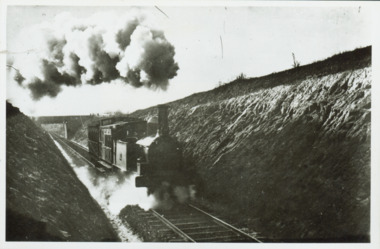 Kew Historical Society Inc
Photograph - Train coming up grade beyond Barnsbury Rd, Deepdene 1905
The Outer Circle Railway was opened in stages in 1890 and 1891, as a steam-era suburban railway line. It traversed much of the modern City of Boroondara, including the suburbs of (from north to south) Kew East, Camberwell, Burwood, Ashburton, and Malvern East. At its longest, it ran from Fairfield station, on what is today the Hurstbridge line, to Oakleigh station, on the current Pakenham and Cranbourne lines.Steam train in a cutting on the Outer Circle Railway line. Exhibition enlargement donated by Stewart West from an original owned by Miss Foley.trains, outer circle railway -
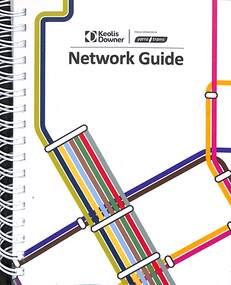 Melbourne Tram Museum
Booklet, Yarra Trams, "Network Guide", 12/2021
Produced by Yarra Trams - Keolis Downer for the information of tram drivers, providing information on each tram route. Dated 12/2021. For each route gives details of the suburbs served, attractions, public hospitals and police stations. The fold out sheets lists every tram stop with with their stop number, stop id, zone and symbols regarding the location such as the Arts Centre. Demonstrates a Yarra Tram publication for the use of employees to provide information to passengers.Wire bound booklet, 24 foldout pages, + 1 sheet + card covers, titled "Network Guide"yarra trams, tram routes, tramways, routes, stop information -
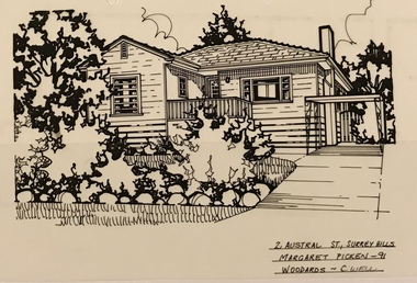 Surrey Hills Historical Society Collection
Drawing - Architectural drawing, 2 Austral Street, Surrey Hills by Margaret Picken, 1991, 1989
Margaret Picken (1950-) trained and worked as a cartographic draftsman from 1968-1975 within the mining industry. These skills were readily transferable to work as a property illustrator for the real estate industry. Process: “Sketches were ordered by phone initially as there were no mobile phones or computers then. I would take our 2 year-old son with me to the houses when the other 2 boys were at school. I photographed houses with a Polaroid camera and made a ‘thumbnail’ sketch while there. The photos were used to scale off a sketch in pencil and then that sketch was overlaid with drafting film and the ‘pen and ink’ was completed. This process was the only one I used the entire time. Polaroid photos gave an instant usable photo. I then delivered the sketches by hand to the offices. There were deadlines each week on a Tuesday.” “… about 2003 coloured photos began to take over the sketches and mainstream companies replaced sole traders like myself providing a one-stop shop for all advertising. I produced my last Real Estate sketches in late 2005.” Margaret Picken (1950-) trained and worked as a cartographic draftsman from 1968-1975 within the mining industry. This architectural drawing is one of a series created by Margaret Picken for a range of real estate agents in Melbourne between 1983 and 2005. Each work is signed and dated. Margaret Picken approached a number of historical societies in July 2020 with a view to donating her work. Sketches for post code 3127 arefheld by this collection. Others for suburbs including Ashburton, Balwyn, Camberwell, Canterbury, Blackburn, Box Hill, Burwood, Glen Iris, Hawthorn, Kew, Mont Albert North and Nunawading have been donated to the relevant historical group in those suburbs. (See Balwyn Historical Society, Box Hill Historical Society, Camberwell Historical Society, Hawthorn Historical Society, Kew Historical Society, Whitehorse Historical Society). In some cases, this collection also has a copy of the matching newspaper advertisement. Pen and ink architectural drawing on drafting film of 2 Austral Street, Surrey Hills (VIC) by Margaret Picken. The drawing, dated 1991, was commissioned by the Woodards real estate company.2 AUSTRAL ST., SURREY HILLS / MARGARET PICKEN - 91 / WOODARDS ~ C'WELLarchitectural drawing, houses, surrey hills / mont albert (vic.), artists, margaret picken 1950-, 1950, austral street -
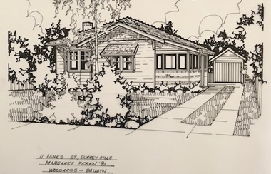 Surrey Hills Historical Society Collection
Drawing - Architectural drawing, 11 Agnes Street, Surrey Hills by Margaret Picken, 1990, 1990
Margaret Picken (1950-) trained and worked as a cartographic draftsman from 1968-1975 within the mining industry. These skills were readily transferable to work as a property illustrator for the real estate industry. Process: “Sketches were ordered by phone initially as there were no mobile phones or computers then. I would take our 2 year-old son with me to the houses when the other 2 boys were at school. I photographed houses with a Polaroid camera and made a ‘thumbnail’ sketch while there. The photos were used to scale off a sketch in pencil and then that sketch was overlaid with drafting film and the ‘pen and ink’ was completed. This process was the only one I used the entire time. Polaroid photos gave an instant usable photo. I then delivered the sketches by hand to the offices. There were deadlines each week on a Tuesday.” “… about 2003 coloured photos began to take over the sketches and mainstream companies replaced sole traders like myself providing a one-stop shop for all advertising. I produced my last Real Estate sketches in late 2005.” Margaret Picken (1950-) trained and worked as a cartographic draftsman from 1968-1975 within the mining industry. This architectural drawing is one of a series created by Margaret Picken for a range of real estate agents in Melbourne between 1983 and 2005. Each work is signed and dated. Margaret Picken approached a number of historical societies in July 2020 with a view to donating her work. Sketches for post code 3127 arefheld by this collection. Others for suburbs including Ashburton, Balwyn, Camberwell, Canterbury, Blackburn, Box Hill, Burwood, Glen Iris, Hawthorn, Kew, Mont Albert North and Nunawading have been donated to the relevant historical group in those suburbs. (See Balwyn Historical Society, Box Hill Historical Society, Camberwell Historical Society, Hawthorn Historical Society, Kew Historical Society, Whitehorse Historical Society). In some cases, this collection also has a copy of the matching newspaper advertisement. Pen and ink architectural drawing on drafting film of 11 Agnes Street, Surrey Hills (VIC) by Margaret Picken. The drawing, dated 1990, was commissioned by the Woodards real estate company.11 AGNES ST., SURREY HILLS / MARGARET PICKEN '90 / WOODARDS ~ BALWYNarchitectural drawing, houses, surrey hills / mont albert (vic.), artists, margaret picken 1950-, agnes street, californian bungalow -
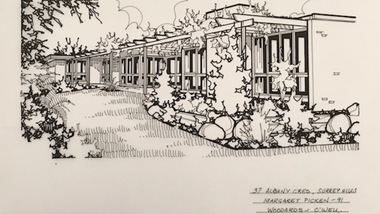 Surrey Hills Historical Society Collection
Drawing - Architectural drawing, 37 Albany Crescent, Surrey Hills by Margaret Picken, 1991, 1990
Margaret Picken (1950-) trained and worked as a cartographic draftsman from 1968-1975 within the mining industry. These skills were readily transferable to work as a property illustrator for the real estate industry. Process: “Sketches were ordered by phone initially as there were no mobile phones or computers then. I would take our 2 year-old son with me to the houses when the other 2 boys were at school. I photographed houses with a Polaroid camera and made a ‘thumbnail’ sketch while there. The photos were used to scale off a sketch in pencil and then that sketch was overlaid with drafting film and the ‘pen and ink’ was completed. This process was the only one I used the entire time. Polaroid photos gave an instant usable photo. I then delivered the sketches by hand to the offices. There were deadlines each week on a Tuesday.” “… about 2003 coloured photos began to take over the sketches and mainstream companies replaced sole traders like myself providing a one-stop shop for all advertising. I produced my last Real Estate sketches in late 2005.” Margaret Picken (1950-) trained and worked as a cartographic draftsman from 1968-1975 within the mining industry. This architectural drawing is one of a series created by Margaret Picken for a range of real estate agents in Melbourne between 1983 and 2005. Each work is signed and dated. Margaret Picken approached a number of historical societies in July 2020 with a view to donating her work. Sketches for post code 3127 arefheld by this collection. Others for suburbs including Ashburton, Balwyn, Camberwell, Canterbury, Blackburn, Box Hill, Burwood, Glen Iris, Hawthorn, Kew, Mont Albert North and Nunawading have been donated to the relevant historical group in those suburbs. (See Balwyn Historical Society, Box Hill Historical Society, Camberwell Historical Society, Hawthorn Historical Society, Kew Historical Society, Whitehorse Historical Society). In some cases, this collection also has a copy of the matching newspaper advertisement. Pen and ink architectural drawing on drafting film of 11 Agnes Street, Surrey Hills (VIC) by Margaret Picken. The drawing, dated 1990, was commissioned by the Woodards real estate company.37 ALBANY CRES, SURREY HILLS / MARGARET PICKEN -91 / WOODARDS ~ C'WELLarchitectural drawing, houses, surrey hills / mont albert (vic.), artists, margaret picken 1950-, albany crescent, 1980 -
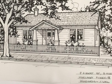 Surrey Hills Historical Society Collection
Drawing - Architectural drawing, 4 Albert Street, Surrey Hills by Margaret Picken, 1990, 1990
Margaret Picken (1950-) trained and worked as a cartographic draftsman from 1968-1975 within the mining industry. These skills were readily transferable to work as a property illustrator for the real estate industry. Process: “Sketches were ordered by phone initially as there were no mobile phones or computers then. I would take our 2 year-old son with me to the houses when the other 2 boys were at school. I photographed houses with a Polaroid camera and made a ‘thumbnail’ sketch while there. The photos were used to scale off a sketch in pencil and then that sketch was overlaid with drafting film and the ‘pen and ink’ was completed. This process was the only one I used the entire time. Polaroid photos gave an instant usable photo. I then delivered the sketches by hand to the offices. There were deadlines each week on a Tuesday.” “… about 2003 coloured photos began to take over the sketches and mainstream companies replaced sole traders like myself providing a one-stop shop for all advertising. I produced my last Real Estate sketches in late 2005.” Margaret Picken (1950-) trained and worked as a cartographic draftsman from 1968-1975 within the mining industry. This architectural drawing is one of a series created by Margaret Picken for a range of real estate agents in Melbourne between 1983 and 2005. Each work is signed and dated. Margaret Picken approached a number of historical societies in July 2020 with a view to donating her work. Sketches for post code 3127 arefheld by this collection. Others for suburbs including Ashburton, Balwyn, Camberwell, Canterbury, Blackburn, Box Hill, Burwood, Glen Iris, Hawthorn, Kew, Mont Albert North and Nunawading have been donated to the relevant historical group in those suburbs. (See Balwyn Historical Society, Box Hill Historical Society, Camberwell Historical Society, Hawthorn Historical Society, Kew Historical Society, Whitehorse Historical Society). In some cases, this collection also has a copy of the matching newspaper advertisement. Pen and ink architectural drawing on drafting film of 11 Agnes Street, Surrey Hills (VIC) by Margaret Picken. The drawing, dated 1990, was commissioned by the Woodards real estate company.37 ALBANY CRES, SURREY HILLS / MARGARET PICKEN -91 / WOODARDS ~ C'WELLarchitectural drawing, houses, surrey hills / mont albert (vic.), artists, margaret picken 1950-, albany crescent, 1980 -
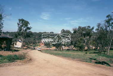
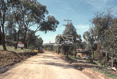
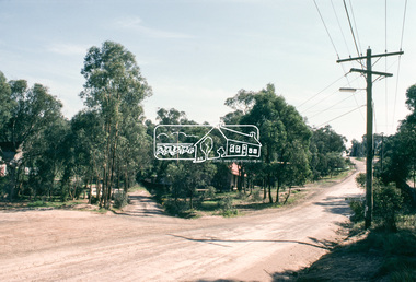
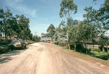
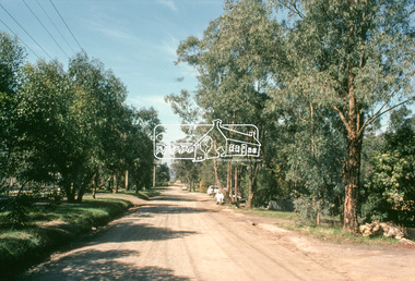
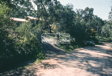
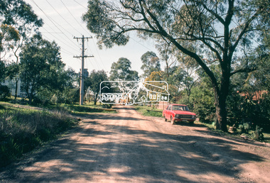
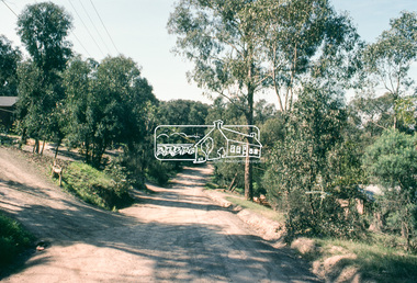
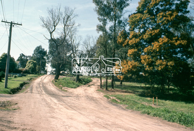
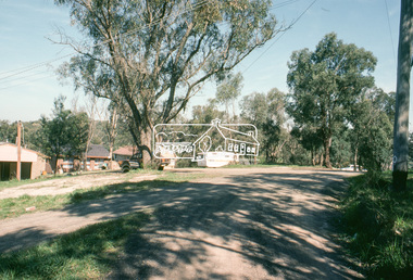
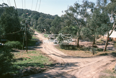
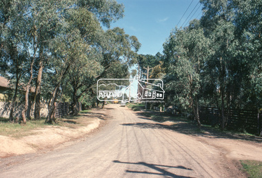
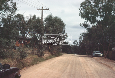
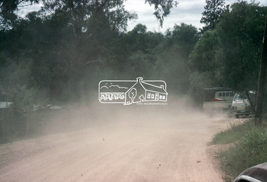
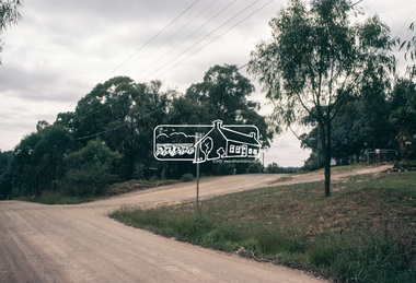
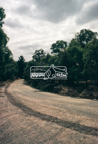
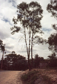
 Eltham District Historical Society Inc
Slide, Adam Crescent, Montmorency, c. Feb. 1981
One of a series of images of road infrastructure focussed on Adam Crescent in Montmorency taken by Eltham Shire Council Planning and Engineering officers. They provide perspective of the changes in housing styles and road development that began sweeping in from the mid 1970s with increasing urbanisation of what was once more outlying suburbs and regions. All images have been identified with GPS though house numbers have changed35 mm colour positive transparency (1 of 21) Mount - Kodak Kodachrome CardProcessed Feb 1981adam crescent, infrastructure, montmorency, roads -
 Eltham District Historical Society Inc
Slide, Adam Crescent, Montmorency, c. Feb. 1981
One of a series of images of road infrastructure focussed on Adam Crescent in Montmorency taken by Eltham Shire Council Planning and Engineering officers. They provide perspective of the changes in housing styles and road development that began sweeping in from the mid 1970s with increasing urbanisation of what was once more outlying suburbs and regions. All images have been identified with GPS though house numbers have changed35 mm colour positive transparency (1 of 21) Mount - Kodak Kodachrome CardProcessed Feb 1981adam crescent, infrastructure, montmorency, roads, gordon grove -
 Eltham District Historical Society Inc
Slide, Adam Crescent, Montmorency, c. Feb. 1981
One of a series of images of road infrastructure focussed on Adam Crescent in Montmorency taken by Eltham Shire Council Planning and Engineering officers. They provide perspective of the changes in housing styles and road development that began sweeping in from the mid 1970s with increasing urbanisation of what was once more outlying suburbs and regions. All images have been identified with GPS though house numbers have changed35 mm colour positive transparency (1 of 21) Mount - Kodak Kodachrome CardProcessed Feb 1981adam crescent, infrastructure, montmorency, roads -
 Eltham District Historical Society Inc
Slide, Adam Crescent, Montmorency, c. Feb. 1981
One of a series of images of road infrastructure focussed on Adam Crescent in Montmorency taken by Eltham Shire Council Planning and Engineering officers. They provide perspective of the changes in housing styles and road development that began sweeping in from the mid 1970s with increasing urbanisation of what was once more outlying suburbs and regions. All images have been identified with GPS though house numbers have changed35 mm colour positive transparency (1 of 21) Mount - Kodak Kodachrome CardProcessed Feb 1981adam crescent, infrastructure, montmorency, roads