Showing 1371 items
matching east side
-
 Eltham District Historical Society Inc
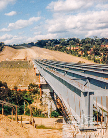
Photograph, Looking east across the new bridge construction across the Plenty River from the western side up to the new roundabout at Civic Drive; Greensborough Bypass construction, c.1986, 1986c
Colour photograph originally located in a magnetic style album titled 'Greensborough Bypass 1990s 5' suffering significant degradation. No information contained in album or on reverse of photos except where noted. Relocated to archival photosafe storage.greensborough bypass, road construction, greensborough, bridge construction -
 Eltham District Historical Society Inc
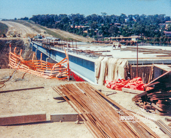
Photograph, Looking east across the new bridge construction across the Plenty River from the western side up to the new roundabout at Civic Drive; Greensborough Bypass construction, c.1986, 1986c
Colour photograph originally located in a magnetic style album titled 'Greensborough Bypass 1990s 5' suffering significant degradation. No information contained in album or on reverse of photos except where noted. Relocated to archival photosafe storage.greensborough bypass, road construction, greensborough, bridge construction -
 Eltham District Historical Society Inc
Photograph, Edendale Farm, Eltham Heritage Tour, 24 May 1992, 24/05/1992
ELTHAM HERITAGE TOUR The Society excursion on 24th May 1992 was arranged by David Bick, leader of the team carrying out the Shire's heritage study. David selected a number of sites or buildings identified in the study, some of them lesser known components of the Shire's heritage. The tour commenced at the Eltham Shire Office at 10.00 am. Travel was by private car and mini-bus with stops at about twelve locations for commentary by David.It included a short walk in Hurstbridge and lunch at Kinglake. Highlights of the tour included: - 10 am Leave from Shire Offices - 3 Important Trees - A Physical Link to Eltham's First Settlers - Toorak Mansion Gates - A Surviving Farm House - An Intact Circa 1900 Main Street - First Settlers - Gold Miners, and Timber-getters - An Early Hotel - A Pioneering Homestead - Changing Eltham Shire - 20th Century - 4 pm Afternoon Tea and Finish Tour Extract from ELTHAM CULTURAL HERITAGE TOUR (Newsletter No. 85, July 1992, by Bettina Woodburn) "The land was unprofitable for intensive farming, but there was always water in the Diamond Creek. The railway, a technological advance, followed the valley, and was provided to transport produce. At North Eltham we were privileged to tour a surviving farmhouse of the 1860-70 era at the Shire’s Edendale Farm, with the as yet unfinished Sculpture for a front fence - bulbous tree-trunks decorated with salt pots, with cross members from the old trestle bridge. As was usual these six veranda posted houses faced South (or East, away from the sun!) with the scullery, kitchen and pantry "out the back". The veranda, which must have been very narrow, no longer exists. It probably wrapped around three sides. The drive took us past the Dutch Windmill, only twenty years old and in the Shire of Diamond Valley, then the Diamond Creek Cemetery with impressive gateway, to a detour to see another old farmhouse, isolated on a hill off Murray Road Wattle Glen. Here was a particularly thick patch of exotic planting of pines and cypresses. Subsistence farming no longer pays. Following the rail-line we noticed on the left near Silvan Road an Edwardian cottage and on the right near Yates Road the old school residence for this Upper Diamond Creek area."Record of the Society's history and activities and highlighting various aspects of the Heritage Study undertaken by David Bick used to create the future heritage overlay for the Shire of Eltham and later Nillumbik Shire.Roll of 35mm colour negative film, 4 stripsKodak Gold 100 5095eltham, shire of eltham historical society, activities, heritage tour -
 Eltham District Historical Society Inc
Photograph, Edendale Farm, Eltham Heritage Tour, 24 May 1992, 24/05/1992
ELTHAM HERITAGE TOUR The Society excursion on 24th May 1992 was arranged by David Bick, leader of the team carrying out the Shire's heritage study. David selected a number of sites or buildings identified in the study, some of them lesser known components of the Shire's heritage. The tour commenced at the Eltham Shire Office at 10.00 am. Travel was by private car and mini-bus with stops at about twelve locations for commentary by David. It included a short walk in Hurstbridge and lunch at Kinglake. Highlights of the tour included: - 10 am Leave from Shire Offices - 3 Important Trees - A Physical Link to Eltham's First Settlers - Toorak Mansion Gates - A Surviving Farm House - An Intact Circa 1900 Main Street - First Settlers - Gold Miners, and Timber-getters - An Early Hotel - A Pioneering Homestead - Changing Eltham Shire - 20th Century - 4 pm Afternoon Tea and Finish Tour. Extract from ELTHAM CULTURAL HERITAGE TOUR (Newsletter No. 85, July 1992, by Bettina Woodburn) "The land was unprofitable for intensive farming, but there was always water in the Diamond Creek. The railway, a technological advance, followed the valley, and was provided to transport produce. At North Eltham we were privileged to tour a surviving farmhouse of the 1860-70 era at the Shire’s Edendale Farm, with the as yet unfinished Sculpture for a front fence - bulbous tree-trunks decorated with salt pots, with cross members from the old trestle bridge. As was usual these six veranda posted houses faced South (or East, away from the sun!) with the scullery, kitchen and pantry "out the back". The veranda, which must have been very narrow, no longer exists. It probably wrapped around three sides. The drive took us past the Dutch Windmill, only twenty years old and in the Shire of Diamond Valley, then the Diamond Creek Cemetery with impressive gateway, to a detour to see another old farmhouse, isolated on a hill off Murray Road Wattle Glen. Here was a particularly thick patch of exotic planting of pines and cypresses. Subsistence farming no longer pays. Following the rail-line we noticed on the left near Silvan Road an Edwardian cottage and on the right near Yates Road the old school residence for this Upper Diamond Creek area."Colour photograph1992, culture, edendale, edendale community farm, events -
 Eltham District Historical Society Inc
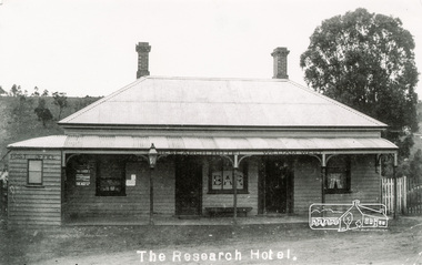
Photograph, Tom Prior, The Research Hotel
William West was the proprietor. Miners on the way to nearby goldfields frequented the hotel. The Post Office on left of photo was inside. Situated east of present day pre-school, there was a small right of way by the side of the hotel. Honeymooners would also thay there.The Reynolds family were early settlers in Research. The Reynolds/ Prior collection of photographs were taken by Tom Prior, the maternal uncle of Ivy Reynolds, around 1900 and the 60 photos in the album give a fine overview of many of the landmarks of Research and Eltham over 100 years ago. lvy lived in the family home for many years at 106 Thompson Cres Research. Ivy's father, Ernst Richard Reynolds and grandfather, Richard Reynolds, lived at the same address. Ivy's father Richard worked for Mr. Trail on his property in Research. Reynolds Road is named after the family. Mr Tom Prior (wife Eva) worked at the Melbourne zoo. He was very innovative and made his own camera, using the black cloth hood to exclude the light. The photographs are a reminder of the rural nature of Research and Eltham and its rich heritage. Black and white photograph mounted in an album, the Reynolds/Prior Photograph Collection, this being one of 53 reproduced black and white images of early Eltham.The Reynolds/Prior Photograph Collection, Presented to the Eltham District Historical Society, 14 June 2006 by Ross McDonald. A second copy was also presented to the Andrew Ross Museum, Kangaroo Groundreynolds prior collection, post office, research hotel, the age, the leader, william west -
 Eltham District Historical Society Inc
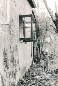
Photograph, South side of the house looking east towards brick storage shed, Eltham Living and Learning Centre
Black and white photographeltham living and learning centre -
 Eltham District Historical Society Inc
Photograph, Edendale Farm, Eltham Heritage Tour, 24 May 1992, 24/05/1992
ELTHAM HERITAGE TOUR The Society excursion on 24th May 1992 was arranged by David Bick, leader of the team carrying out the Shire's heritage study. David selected a number of sites or buildings identified in the study, some of them lesser known components of the Shire's heritage. The tour commenced at the Eltham Shire Office at 10.00 am. Travel was by private car and mini-bus with stops at about twelve locations for commentary by David. It included a short walk in Hurstbridge and lunch at Kinglake. Highlights of the tour included: - 10 am Leave from Shire Offices - 3 Important Trees - A Physical Link to Eltham's First Settlers - Toorak Mansion Gates - A Surviving Farm House - An Intact Circa 1900 Main Street - First Settlers - Gold Miners, and Timber-getters - An Early Hotel - A Pioneering Homestead - Changing Eltham Shire - 20th Century - 4 pm Afternoon Tea and Finish Tour. Extract from ELTHAM CULTURAL HERITAGE TOUR (Newsletter No. 85, July 1992, by Bettina Woodburn) "The land was unprofitable for intensive farming, but there was always water in the Diamond Creek. The railway, a technological advance, followed the valley, and was provided to transport produce. At North Eltham we were privileged to tour a surviving farmhouse of the 1860-70 era at the Shire’s Edendale Farm, with the as yet unfinished Sculpture for a front fence - bulbous tree-trunks decorated with salt pots, with cross members from the old trestle bridge. As was usual these six veranda posted houses faced South (or East, away from the sun!) with the scullery, kitchen and pantry "out the back". The veranda, which must have been very narrow, no longer exists. It probably wrapped around three sides. The drive took us past the Dutch Windmill, only twenty years old and in the Shire of Diamond Valley, then the Diamond Creek Cemetery with impressive gateway, to a detour to see another old farmhouse, isolated on a hill off Murray Road Wattle Glen. Here was a particularly thick patch of exotic planting of pines and cypresses. Subsistence farming no longer pays. Following the rail-line we noticed on the left near Silvan Road an Edwardian cottage and on the right near Yates Road the old school residence for this Upper Diamond Creek area."Colour photograph1992, culture, edendale, edendale community farm, events -
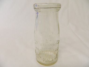 Kiewa Valley Historical Society
Bottle - Cream, 1935
Cream came in bottles bought at the local store or at a large city store on a shopping expedition. The shape of the bottles changed as did the stopper used to seal it. The amount of liquid was measured in ounces and pints pre 1966. History of J. Kikpatrick, Waverley, East malvern.Historical: Change of bottles - shape, size, stopper, embossing and use. Aesthetic; Display showing embossing and shapeClear small glass cream bottle with heavy embossing on both sides. Inside the opening is a rim to hold a cardboard disc used to seal the bottle. The sides are straight half way up then taper to the opening. One side: The Property of / J. Kilpatrick (half moon on top) / Waverly Road (across middle) / East Malvern (half moon on bottom) Other side: Please / wash / & / Return (also curved with & in the middle) Along side at base: "Contents not less than 8 ozs." Base: Across middle M93 above M, and AGM below. cream, dairy, milkbar, bottle, household -
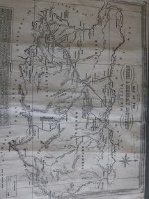 Kiewa Valley Historical Society
Map of the Ovens and Murray District of Victoria
The map features Beechworth and its history.This map features the north-east and in particular, Beechworth where residents of the Kiewa Valley may have shopped or visited for appointments.Black and white map with references to roads and gold. The centre of the map is Beechworth and in the bottom left side of the map is the heading Beechworth with 12 lines of print of information regarding Beechworth. The Kiewa Valley is not identified.beechworth -
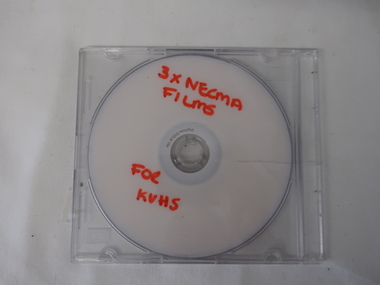 Kiewa Valley Historical Society
DVD - NECMA Films, Cultural Burning, Stone Implements, Weaving, Plants
The North East Catchment Management Authority presents Indigenous knowledge and practices on film by way of a DVD allowing it to be played on a screen such as a computer or linked to a TV screen.Indigenous knowledge and practices presented by film on a DVDDVD with title in red texta on silver side of DVD. Stored in hard, clear plastic containerRed Texta printed -' 3 x NECMA / Films / for / KVHSindigenous australians, north east catchment management authority, dvd film -
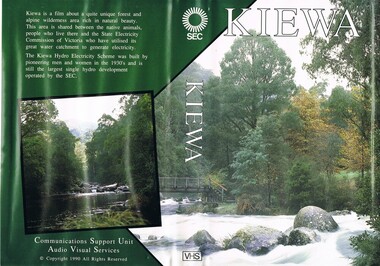 Kiewa Valley Historical Society
VHS Tape - Kiewa Hydro Electricity Scheme x2, Kiewa, Circa 1990
This VHS was produced by the State Electricity Commission of Victoria, to show the pristine state of the Kiewa River and Valley post the completion of the Kiewa Hydro Electricity Scheme (Circa 1950s), The late 1970s on wards was the beginning of deeper social scrutineering by pro environmental groups such as the Australian Wilderness Society (1976) and the Greens (political Party), before, during and after the construction phases of any man made structures in forest/bush areas which may or could damage or adversely affect the natural flora and fauna of sites. This promotional VHS, which was produced in the 1990s, was to project that unlike the Tasmanian State Electricity Commission (Franklin Dam issue), the Victorian State Electricity Commission acted in a way to protect the environment to the maximum level possible. With the passage of time since, and the issue of the global push to minimise carbon pollution, and as an alternative to coal fired power stations, the use of hydro electricity can now be seen as a highly efficient alternative to "coal powered" electricity. This VHS is a snap shot in time (1990) when the Kiewa Valley was still relatively under populated and holiday houses owned by city bound workers was still relatively insignificant. As more and more holiday makers retire to a small but friendly region(Kiewa Valley and Mount Beauty) the increase in visitor numbers will affect the local rural bush scene more and more. The changes that will occur (in time) can be measured against the scenes presented in this video. The additional resources provided by the State Electricity Commission of Victoria of "alpine bush" fire control and management, together with an ongoing educational scheme for school children in learning about what constitutes the Alpine country's unique environment, are a very important offshoot, benefitting to both the communities within the Kiewa Valley and regional Victoria.This VHS tape is stored within its own plastic cover which has a front side covered by a coloured photograph(both front and back cover) of the Kiewa River, just to the north east of the Mount Beauty township. The VHS tape is nestled within a formed inner structure which not only prevents the tape from moving to and fro but also unnecessary intrusion of foreign particles.Front cover "KIEWA" on the spine top circle with lines projecting out and below this "SEC". Middle of spine "KIEWA" and bottom of spine "VHS"secv, kiewa valley, dale-bromley, cy-duff, chris- harding, michael-glucz, forestation education, wilderness photography, nature film. -
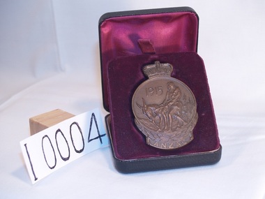 Doncaster RSL Sub Branch
1915 ANZAC Medal
Medal awarded to persons who served at Gallipoli in 1915 W A E Bragg No 86 23rd Battalion first A. I. F. Enlisted February 1915 age 18 ( August 1914) sailed 08-05-1915 returned 22-05-1919In In commemoration of the heroic deeds of the men of ANZACMedal 50mm diameter with crown protruding at the top and ANZAC at the bottomCenter of medal depicts Simpson an his donkey. The reverse side shows Australia and New Zealand with five stars and W A E Braggs engraved at the bottomworld war one, medal, anzac, australia, new zealand, wwi, simpson, donkey, stars, w a e braggs, gallopoli -
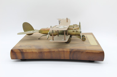 Warrnambool RSL Sub Branch
Artefact, Trench Art- Model Bi-plane WW1, C1915- 1918
Trench art was typically made by soldiers from pieces of shell and shrapnel, which would have been collected and refashioned into many different objects ,some being of a functional type such as containers and holders while others such as this are more decorative. The maker of this art piece was Stanley Morgan 6383 who was born at Mepunga which is East of Warrnambool.This item has significance being a typical example of trench art which has survived over 100 years. Being linked to one of the largest conflicts in which Australia has engaged it has strong historical significance.This model is constructed of metal and wood. It has a propeller mount on either side of the cockpit with propellers front and back. It has two German crosses on the back and one on either wing.The body of the plane rests on four wheels which sit under the wings with two smaller wheels at the front.There is a gold coloured plaque mounted at the front. It stands on a modern wooden mount,On small plaque at front of mount,”Crafted by Trumpeter Stan Morgan France WW1. On the base of the mount on a small sticker,”Mr Lloyd Morgan 19 Mountfield Ave Malvern East Vic 3145warrnambool, trench art, stanley morgan 6383, morgan mepunga -
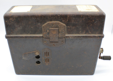 Warrnambool RSL Sub Branch
WW2 Field Telephone/Communication Instrument; German
Used in WW2. Basically of german origin and manufacture but 'English' handset suggests capture and use by Australian forces possibly in Middle East Desert warfare.Black Rectangular Metal Box with Lid. Total Height 215mm (with lid closed), Body Height 140mm. Lid Height 75mm.Lid attached by full length Hinge on rear and locking Clip at front.Depth 90mm. Length 275mm. Lid Outside: has overlapping lip to body when closed.Reinforcing metal attachment on left side rolls over to inside of lid and is attached by two screws. Front locking clip is spring loaded and attached to lid by 3 screws. Lid Inside: Flexible metal plate to clip on handset. 2 inscription plates on left and right ends and telephone handset described separately Body Outside:Front: 2 Jack plug points, vertically aligned 85mm from left, 25mm apart either side of mid point of height of bodyprotedted by protective pivot plate. Air vent plate attached with 2 screws adjacent to Jack plug holes (same on Back). Left side at top; metal plate for carry strap (same on right side). carry strap not with item.Right side; hole covered by protective cover plate centred 70mm from base , Wind-Up handle attached (described seoarately. Body Inside: 2/3 filled with visible metal and bakelite components in separate compartment containing unseen working parts. Left side contains morse code key in canvas bag (described separately). Contents Inside Lid. Two schematics of wiring layouts attached to left and right ends. Removable Bakelite handset clipped into postion for carrying, attached cable has 4-pronged attachment connected to main section in body. Contents Inside Body. Most working parts hidden inside metal container. White plastic button 'Pruttaste' is a test button; threaded screws on top for attachments not present.Two pieces of loose wire purpose unknown. Canvas Bag with zip, labelled DD with arrow between (Department of Defence) containing Morse Code Key; wire with large jackplug attachment connected to MC Key through the bag. Jackplug connects via front of body of object. The whole of this item is stored in left inside of body.underside of handset says PRESS KEY WHILE SPEAKING and in smaller font size TELE HD NO 2 -
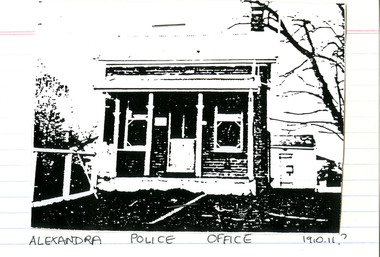 Victoria Police Museum
Police Stations (Alexandra)
Alexandra is a regional centre in the Shire of Murrindindi in Victoria, Australia and 130 kilometres north east of Melbourne. Alexandra Police Station opened in the Benalla Police District on 8 May 1867 in Bon Street, on the north side near Grant Street. When the station opened it was staffed by one Senior Constable; one 1st Constable (Mounted); one Foot Constable. The original building was a nine-roomed brick building with an iron roof on land measuring 84' x 97’. The house included a wash-house, pantry, bathroom, office, one W.C., stabling for three horses, a lock-up with two rooms and a single man's room. It closed in June 1977 and was replaced by a new police station which opened on 16 June 1977 in Bon Street, on land adjacent to the old police station. For a list of Officers in Charge 1871 to 1943 contact Victoria Police Museum1 black and white photo and 3 colour photospolice stations; alexandra police station -
 Victoria Police Museum
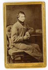
Carte de Visite (Dan Kelly seated), Dan Kelly
Carte-de-visite is a small black and white photograph stuck to a card. It was invented by French photographer Andre Disderi in 1854 as a method for producing multiple images on a single glass plate, a format for mounting the resulting images on cards. The card on which the photograph was mounted displayed the name of the photographer on the front and back. The back was often a showy piece of lithographic printing with the photographer's name decorated with culicues.Sepia toned photograph on cardboard showing Dan Kelly sitting "Burman Photo 200 Bourke St East & St Georges Hall (under photograph), "From Burman's Photographic Rooms 209 Bourke Street, East Near Parliament Houses. st Georges Hall Next to Theatre Royal Melbourne. Portraits Enlarged, Copied or Colored. Views taken in any part of Victoria. Copies of this can be had at any time" (on rear), "Dan Kelly" (on rear along left side in black ink), "204" (written in pencil at top left corner)dan kelly, kelly gang, ned kelly, carte-de-visite, burman -
 Victoria Police Museum
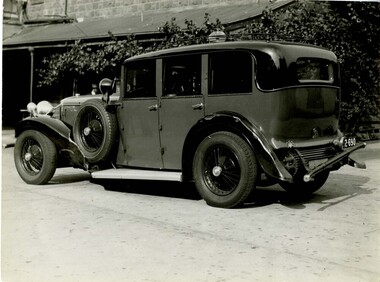
Photograph (police car), Kodak
Daimler registration number 2-690 with damage to rear bumper and front left hand side mudguard, circa 1934No. 2 Daimler Reg No. 2690. Damaged in collision with Fiat sedan No. 60-868 at the intersection of Inkerman Road and Alexander Street East St Kilda on 10/4/34. First Const. MacPherson 6953 driver. Senr Const. Fowles in chargepolice vehicles; transport; motor police branch; daimler car; wireless patrol -
 Warrnambool and District Historical Society Inc.
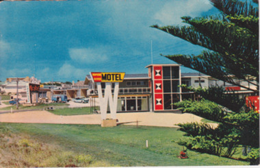
Postcard - Post Card Warrnambool Motels, Circa 1960’s
... of Warrnambool as it was beginning the expansion on the East side ...These two motels were built in the 1960’s on the eastern outskirts of Warrnambool on the corner of the old Princes Highway and Simpson St. They were both built around 1960. The Turn In was originally known as Freeland’s Turn In. The Hopkins River, later the Riverside Motel, was demolished in around 2000. This photograph provides a view of Warrnambool as it was beginning the expansion on the East side of Warrnambool. The buildings depicted are very typical of the style of buildings of the 1960.s Coloured photograph postcard depicting the Hopkins River Motel. Large red and yellow sign mounted on top of a white ‘W’ Part of Norfolk pine. The back is unused. Nucolorvue productions Pty Ltd. W4. Printed in Australia. Printed in Australia. warrnambool, freeland’s turn in, hopkins river motel, turn in motel, warrnambool motels -
 Eltham District Historical Society Inc
Photograph, Russell Yeoman, Construction of fire access on Gumtree Road, Research, by Army Reserve Engineers under command of Captain Bill Oakley, c.1966, 1966c
Bill Oakley was an engineer at the Shire of Eltham. Viewed from west looking east. Road had more zigs and zags in those days on the west side. Russell Yeoman's FC Holden visible at bottom of hill. Digital file only; created from original colour positive slide transparencyresearch (vic.), russell yeoman collection, gumtree road, army reserve engineers, captain bill oakley, fc holden sedan, fire access, streets -
 Ringwood and District Historical Society
Memorial prize presentation box, Presentation box of the Ringwood Mountain District Sports Association with six small metal plaques for the years 1936-1944, 1936 -1944
Presentation box of the Ringwood Mountain District Sports Association (RMDSA) The badges are for RMDSA Premiers 1936 Rounders RMDSA Football Ringwood East Premiers Section A 1938 RMDSA Premiers Rounders 1940 Ringwood East . Also 1941 Section A Ringwood East and 1944 .Box of fiddleback wood with glass front. Along lower edge and right hand side front six metal badges for sporting achievements of the Ringwood Mountain District Sports Association. Four shield shaped and two rectangular badges. Years 1936 -1944 -
 Ringwood and District Historical Society
Photograph - Newspaper Clipping, Early View of Club Hotel, Ringwood East
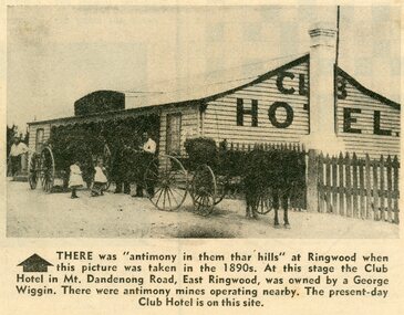
The newspaper clipping caption is incorrect. The Club Hotel featured in the article was located on the north side of Mount Dandenong Road. It was destroyed by fire in 1890 prior to re-opening later on the south side where it operated until sale and demolition in 2020 to make way for a retirement village. (See PDF attached - "SS0067 Vic Collections 3754b - Club Hotel Fire 1890").Early View of Club Hotel, Ringwood East. Weatherboard with iron roof. Single chimney on one end. Picket fence on RHS. Two horse-drawn vehicles standing out front including three adults and two children. Source/date of newspaper unknown. Later newspaper item also attached reporting hotel being destroyed by fire in 1890.Caption: There was 'antimony in them thar hills' at Ringwood when this picture was taken in the 1890s. At that time the Club Hotel in Mt Dandenong Road, East Ringwood was owned by a George Wiggin. There were antimony mines operating nearby. The present-day Club Hotel is on this site. -
Ringwood and District Historical Society
Audio - Recording - Vinyl, Recorded at S.D.A. Academy, Lilydale, by Bob Clarke, Choir of St Stephens, Ringwood East. Vinyl Record with printed insert. 1975, Aug-75
Vinyl record 12 inch 33 1/3 rpm, two - sided, stereo. Held in white sleeve and plastic pocket. Yellow label at the centre with text. 'Produced by the choir of St Stephens, Ringwood East.' There is a printed insert. -
 Ringwood and District Historical Society
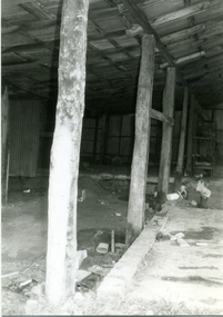
Photograph-B&W, Hill's Dairy, Canterbury Road, Ringwood 1989-Barn interior, 6/07/1989
Hill's Dairy, Canterbury Road, Ringwood 1989- Roof supports in the centre of the barn. Taken at last two posts. East of those in picture 4 (RDHS Catalogue No 6502-004) on their northern sideRoof supports in the centre of the barn / Taken at last two posts / East of those in picture 4 (RDHS Catalogue No 6502-004) on their northern side -
 Ringwood and District Historical Society
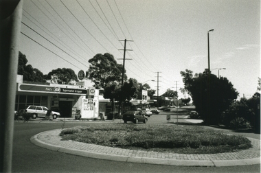
Photograph-B&W, Joan Walker, East Ringwood 2000- Roundabout in Railway Avenue cnr Wenwood Street looking West (railway line on right hand side), 2000
East Ringwood 2000- Roundabout in Railway Avenue cnr Wenwood Street looking West (railway line on right hand side)- B&W Photo from Album 6501 -
 Ringwood and District Historical Society
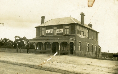
Photograph, Club Hotel, Mount Dandenong Road, (East) Ringwood, Circa 1900
Brick hotel with veranda. Sign above veranda reads "De Beer's Club Hotel" Sign on side of building reads, "Club Hotel - De Beer"(De Beer added to original Club Hotel sign - See item #2819 for earlier photo)Was H006. Photographed by "The Studio of Ringwood" -
 Ringwood and District Historical Society
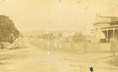
Photograph, Bedford Rd / Bayswater Rd. looking east from Warrandyte Rd. railway underpass, c1910
Dirt Road with houses and planter boxes for street trees on one side.Multiple copies of photos SS0078 and SS0079 - Backing sheet on one reads "Bedford Rd. looking east from Warrandyte Rd. railway underpass, c1910". Others have Bayswater Rd, Bedford Rd etc names. Some copies state "Ringwood House on Right". There is a also a postcard version. SS0079rev is an image of the postcard reverse, dated feb 24 1910 -
 Orbost & District Historical Society
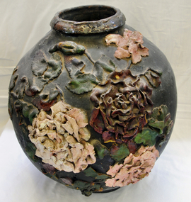
ginger jar, Pre 1893 floods in Orbost
In the early days of Orbost many Chinese were engaged in land clearing or had arrived when gold was discovered in East Gippsland in the 1840's. They lived in camps along the Marlo Road and houses were usually built on stilts. They left after the 1893 floods.This object has aesthetic appeal. It is an object which belonged to the very early settlement days of Orbost.Huge, ornate Chinese ginger jar. Four raised hand- painted pink roses on front. Jar itself is matt black. Looks more like a vase than a ginger jar. Ceramic.Some Chinese writing to left hand side of roses.ceramics, ginger jar, container - domestic, vase -
 Orbost & District Historical Society
black and white photograph, Wilson, Len G, 1920s
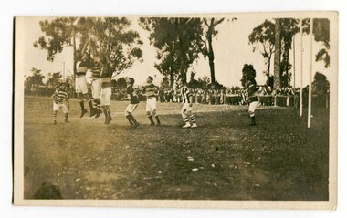
The Orbost football club players were known as the Busters and wore green and gold guernseys. An Orbost football team has participated in the East Gippsland League since the early 20th century. In 2003 in response to a dwindling population, the Snowy Rovers and Orbost Football Clubs were driven to merge into the Orbost Snowy Rovers Football clubs, through their many changes, have always been an important social fabric of the community. Sport is often regarded as an important part of life in rural Australia, contributing to community identity, sense of place, social interaction and good health.A black / white photograph of men playing football. Three men are jumping for the ball. The goal posts are on the right side. A large group of spectators are at the rear behind a fence.recreation sport-football orbost-football-club -
 Orbost & District Historical Society
black and white photographs, April 1916
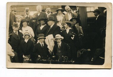
These photographs were taken at the official opening of the Orbost - Bairnsdale Railway Line. In 3150.3 which is of a group of children and two adults those identified in the photograph are ; L - R front row Mary Gilbert; Warren; Betty Gilbert; Marion Gilbert; Mrs Shaw and son; ? Gay; and Pen Gilbert. In 3150.4 L-R front " Mary Gilbert; Bet Gilbert (sitting with glasses); Pen Gilbert(Richardson); Marion Gilbert ( middle front little girl) About 1912 work began at Newmerella on clearing the track for the railway line from Bairnsdale to Orbost. A canvas town sprang up on the higher land adjacent to the river flats. Local farmers supplied meat, milk and fresh produce to the camp, as well as gaining employment carting and labouring. The line opened in 1916, the Orbost railway station being built on the Newmerella side of the river.This item is associated with the history of the Orbost-Bairnsdale railway line and therefore reflects the role that the rail line played in the social and economic history of Orbost. It is a pictorial record of a significant event in Orbost's history. On April 10 1916, the first scheduled train service left Orbost for Bairnsdale. The Bairnsdale-Orbost railway was opened to serve the agricultural and timber ndustry. Because of the decline in traffic and heavy operating costs, the line was finally closed in August, 1987. Four black / white postcards of people at the opening of The Orbost - Bairnsdale Railway. 3150.1 - on front - "The Ministerial Party" 3150.2 - on front - hand-written - " The Hon James Cameron" with arrow pointing to a man standing in the back row. at bottom - "The Ministerial Party X Florie Cameron" on back- "Opening the Orbost Railway" 3150.3 and 3150.4 - on back - hand-written "First train to Orbost with a list of names.orbost-bairnsdale-railway celebration-opening-of-railway east-gippsland-railway -
 Orbost & District Historical Society
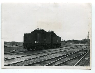
black and white photographs, second half 20th century
3151.1 is of a water tanker on stand by at Orbost ready for emergency use. Similar suppliers were at Bairnsdale and Nowa Nowa. The two tankers hels about 9,000 gallons (34068.7 litres) - from a news item in "Gippsland" September, 1971. 3151.2 is of Victoria's X class 1,800 H.P general purpose diesel electric locomotive. Si had been ordered for the Victorian Railways and cost about £ 250,000 each. 3151.3 is of several loaded, covered railway trucks on a rail line. 3151.4 was taken at the goods yard at Orbost Railway Station. 3151.5 has some rail wagons with "SHOWMOBILE COUNCIL OF ADULT EDUCATION" on the sides. 3151.6 is of goods wagons (Probably not at Orbost Station) 3151.7 is a goods train 3151.8 shows the loading or unloading of farm produce at Orbost railway Station. 3151.9 shows cattle being loaded at Orbost Railway Station. 3151.10 is of a container N.Y.K. LINE ( a Japanese shipping company) This item is associated with the history of the Orbost-Bairnsdale railway line and therefore reflects the role that the rail line played in the social and economic history of Orbost.Ten black / white photographs related to Orbost rail. orbost-railway east-gippsland-railway transport-railway railway-engine orbost-railway-station export-produce