Showing 4075 items matching "survey"
-
 Bendigo Military Museum
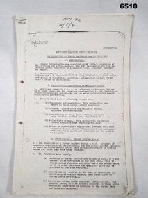
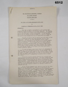
Administrative record - Artillery Training No24 - The employment of Survey Batteries RAA in the Field, HQ RAA 6 Aust Div, 4 Dec 1944
Royal Australian Artillery (RAA) Survey Batteries in the field worked in conjunction with the Australian Survey Corps. This document provides guidance for that interaction. This document was onforwarded to the ExFortuna Survey Association from 4 Fd Svy Sqn in Aug 2024.18 pages of typed notes on letter sized paper, stapled top left corner. This is a photocopy of an original that is held at the Australian War Memorial ACT (AWM 52)royal australian survey corps, rasvy, fortuna, army survey regiment, army svy regt, asr, royal australian artillery, raa -
 Bendigo Military Museum
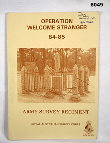
Administrative record - Army Survey Regiment - Operation Welcome Stranger - Operation Report
Operation Report of Mapping areas in central Victoria in 29 Mar 84 - 6 Mar 85. Covering 1:250,000 map areas SJ54-4 St Arnaud, SJ 55-1 Bendigo, SJ54-8 Ballarat, SJ %%-2 WangarattaAn A4 booklet sepia cardboard cover, brown text Survey Corps Badge, Photo of " Welcome Stranger Monument", outline shape of Victoria, glide on Arnos fastener binder.royal australian survey corps, rasvy, fortuna, army survey regiment, army svy regt, asr -
 University of Melbourne, Burnley Campus Archives
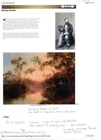
Photograph - Web page, Sue Murphy et al, The Survey Paddock 1861, 1861-2011
Copy of Scan of photograph of painting in the National Gallery of Australia collection, "The Survey Paddock 1861" by Nicholas Chevalier. Donated by Sue Murphy (FOBG Committee) 17 March 2011.painting, national gallery of australia, the survey paddock, 1861, nicholas chevalier, sue murphy, fobg, survey paddock -
 Bendigo Military Museum
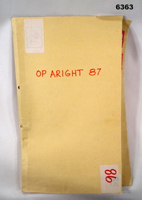
Administrative record - Royal Australian Survey Corps Report on Operation Aright 87 conducted by 1 Field Survey Squadron 1987, 1 Fd Svy Sqn, 26 Aug 1987
1 Fd Svy Sqn in conjunction with 2 Fd Svy Sqn conducted Operation Aright 87 in the Cape York Peninsula area over the period 8 May - 18 Jun 1987. The aim of the Survey Operation was to field verify the 70 x 1:50,000 map sheets which comprised the area of operations. This report details the activities conducted and the results achieved. Manilla Folder with title "OP ARIGHT 1987" containing a paper report of typed pages and diagrams bound together with an ARNOS fastener."OP ARIGHT 87" on front coverroyal australian survey corps, rasvy, fortuna, army survey regiment, army svy regt, asr -
 Federation University Historical Collection
Book, Historic Sites Survey: North Central Study Area, 1979, 1979
The North Central Study Area included the Shires of Avoca, Bet Bet, east Loddon, Goulburn, Untly, Kara Kara, Korong, Maldon, Marong, Metcalfe, McIvor, Newstead, Strathfieldsaye, Stawell, Talbot, Clunes, Tullaroop and Waranga. 153 page book with white plastic binding. It is an historic sites survey for the North Central Study Area commissioned by the Land Conservation Council, the Ministry for COnservation and the Australian Heritage Commission. castlemaine, mount alexander goldfield, maldon, percydale, warrenmang, moliagul, tarnagulla, stuart mill, the whipstick, whroo, rushworth, graytown ironbark forest, st arnoaud, new bendigo, landsborough, inglewood, kurting, wedderburn, wehla, kooroora, langham flat, mcintyre, rheola, diamond hill, fosterville, coliban water works, green gully, newstead, muckleford forest, costerfield, graytown, bailieston, waranga irrigaiton system, eucalyptus distillery, mia mia bridge, korokubeal township researce, concegella slate quarry, chewton, fryerstown, kingower, timor, talbot, majorca, carisbroook, clunes, st arnaud, taradale, icomos, dunolly, limestone, castlemaine slate quarry, harcourt granite, taradale railway viaduct, loddon united waterworks trust, gouldburn weir, carisbrook lock-up, history of tree planting in streets, history of public reserves, r.u. nicholls nurseryman, thomas lang, francis moss, ballarat botanical gardens, ballarat school of mines botanical gardens, lake wendouree, victoria park, ballarat, muont holled smith, ballaarat old cemetery planting, eastern oval, ballarat east botanical gardens, ballarat east town hall gardens, eureka stockade reserve, ballarat observatory plantings, yarrowee creek plantings, yarrowee bluestone channels, ballarat woollen mill, band and albion mullock heap, black hill plantings, yarrowee creek channels, canadian creek channel, specimen vale channel, poverty point reserve, union jack reserve buninyong, imperial mine, buninyong, victoria street plantings, bridge mall, sturt street gardens, ballarat avenue of honour plantings, white flat oval plantings, camp street, elms, burnt creek -
Stawell Historical Society Inc
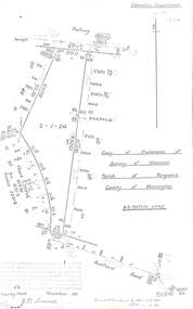
Map, Department of Lands and Survey, Borough of Stawell. Parishes of Stawell and Illawarra 1903, 1903
Victoria Co., St Georges Co., Wimerra Co., Leviathon Co. Tramway, Quarry reserve, Newington Co., Galatea Co., Moonlight Co., Federal Co., Borough reservior., A0 Map of Stawell on linen backing. Plus one Printed on PaperPhoto Lithograped at the Department of Lands and survey Melbourne by T.F. McGauran 13.6.03surevy -
National Wool Museum
Report, Australian Wool Corporation survey for market potential of wool minority blends
"Australian Wool Corporation survey for market potential of wool minority blends " - WD Scott & Co Pty Ltd : a survey of Australian garment manufacturers and retailers.textile industry fashion textile fibres textile fibres - synthetic, cloth - woollen, cloth - worsted, textile industry, fashion, textile fibres, textile fibres - synthetic -
 Melbourne Tram Museum
Pamphlet, Yarra Trams, "Results of the Yarra Tram's new beginning survey", c1998
Pamphlet - DL - 3 fold, full gloss paper titled" Results of the Yarra Tram's new beginning survey" Looks at the results of a survey, both construction (eg maps, shelters, stop announcements), compliments etc. Main items were having daily tickets available on trams, re-introduce conductors, improve frequency, announcements and punctuality. Has a message from the CEO of Yarra at the time, Steve MacDonald. Two copies held.trams, tramways, yarra trams, surveys, conductors, tickets, tram stops -
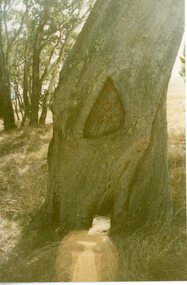 Stawell Historical Society Inc
Photograph, Survey Tree with markings at Lake Lonsdale -- 2 Photos
Survey Tree at Lake Lonsdalestawell -
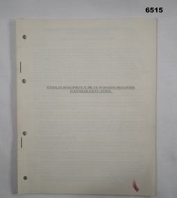 Bendigo Military Museum
Administrative record - Royal Aust Svy Corps - Aust developments in the use of hovering helicopters to establish survey control - MAJ W Childs circa 1960, Major W Childs (RASvy), Circa 1960
An RASvy document about the development and trials in the use of hovering helicopters to establish survey control. Written by MAJ W Childs (RASvy) in circa 1960. Survey Control is points of known accurate position. 10 x A4 page report, hole punched and stapled. Booklet of typed text and diagramsroyal australian survey corps, rasvy, fortuna, army survey regiment, army svy regt, asr -
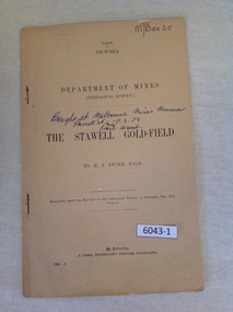 Stawell Historical Society Inc
Book, E.J. Dunn, Department of Mines Geological Survey The Stawell Gold Field - Previously Cat No 3643-1, 1909
A short Geological analysis of the Stawell Gold FieldsFawn Paper cover with two staples along spine1909 Victoria Department of mines (Geological Survey) {in Ink} Brought at Melbourne Mines Museum, Russell St 7.3.78. Ron Wood} The Stawell Gold Field By E.J. Dunn F.G.S Replicated from the Records of the Geological Survey of Victoria, Vol III. Part 1. By Authority J. Kemp, Government Printer, Melbourne. 7290 -2stawell mining -
 Eltham District Historical Society Inc
Document - Folder, Victoria Archaeological Survey, 1982-1990
sites, structures, archaeological significance, victoria archaeological survey -
Port Melbourne Historical & Preservation Society
Book - Reference, Gary Presland, Records of the Victorian Archeological Survey, 1977 - 1983
Purchased from Information Victoria, circa 2000Victorian Archeological Survey books by Gary Presland (editor or author). .01 - No5, 1977. Journals of George Augustus Robinson Jan -March 1840 (light orange cover 96 pages plus fold out route map) .02 - No 6 1977. Journals of George Augustus Robinson March - May 1841 (orange cover 102 pages plus fold out route map and illustrations) .03 - An archeological survey of the Melbourne Metropolitan area 1983 (yellow cover 136 pages)australian aborigines, natural environment, gary presland, george augustus robinson, archeology -
 Ballarat Tramway Museum
Document - Form/s, Ballarat Tramway Preservation Society (BTPS), "Ballarat Tourist Tramway Passenger Survey", 1975
Duplicated sheet of foolscap paper, titled "Ballarat Tourist Tramway Passenger Survey", - form. Has two forms per sheet - layout different, but questions the same. Used 1975. Asks 15 questions.trams, tramways, btps, forms, surveys -
University of Melbourne, Burnley Campus Archives
Card, The University of Melbourne, Survey of the Australian Hydroponics Industry, 1996
hydroponics, crops -
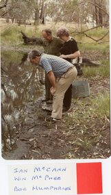 Stawell Historical Society Inc
Photograph, Stawell Field Naturalists – Mammal Survey in the Grampians -- 6 Photos -- Coloured
Stawell Field Naturalists – Mammal survey Grampiansstawell -
 Bendigo Military Museum
Administrative record - The story of the Royal Australian Survey Corps - Brigadier L Fitzgerald OBE, FIS 1962, Brigadier L Fitzgerald OBE, FIS Aust, Canberra, March 1962
This is a report prepared by the Director of the Royal Australian Survey Corps Brigadier L Fitzgerald OBE, FIS Aust for presentation at the Institution of Surveyors, Australia, 6th Survey Conference held in Adelaide in March 1962. This document mentions the beginning of mapping in 1907 in the Australian Intelligence Corps and how the Survey Corps was formed in 1915. The story continues until 1962. A full copy of the report is attached as a video in .mp4 format.14 x page typed foolscap size paper report, stapled and 4 x hole punched. Each page has been photographed at 200dpi and saved in .jpg format. The complete set of these .jpg pages have then been combined into a video in ,mp4 format. The Video is 1.34Mb in size and runs for 2:48 min 48.Some handwritten notes next to some paragraphs by an unknown author.royal australian survey corps, rasvy, fortuna, army survey regiment, army svy regt, asr -
 Federation University Historical Collection
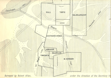
Plan, Underground Survey of Mines, Ballarat East, 1885, 09/1889
Surveyed by Robert Allan under the direction of the Secretary of Mines.Rectangular plan showing placement of mines in 1889. Mines include Hick's and Gilpin's lease, Comstock, Melbourne Company, Victoria United, Speedwell Company, New Normanby, Pasha Surprise, Central Sulieman, West Llanberris, Britannia United, Victoria Unites, Clinton's, Orient Company, North Sulieman, Sulieman Extended, Pasha Surprise, Golden Fountain, Prince regent, Clark and Company, Tinworth, North Woah Hawp, Detering, R.A. Thompson, Dazelles and buchanan, Barnett, Braybrook, Ladt Cornwall, Hanthorne, Dalzelles and gay, Southern Cross, M. Acheson, Cricket Reserveballarat east, mines, mining, underground survey, robert allan, chinese, ah chong, ah young, bakery hill, black hill, black hill lead, bakery hill lead, cricket, pennyweight hill, gravel pitts lead, golden point lead, navy jack's lead, mopoke lead, eureka lead, association lead, warrenheip lead, cgt, plans -
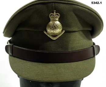 Bendigo Military Museum
Uniform - SERVICE DRESS, ARMY - Royal Australian Army Survey Corps Uniform, Commonwealth Govt Clothing Factory, 1970-1988
This is the peaked cap and uniform of 36898 Warrant Officer Thomas William Pattison, Royal Australian Survey Corps, Army Survey Regiment who served from 21 Mar 1960 until 16 Jan 1993 and died whilst in service.1. Cap - Polyester, Khaki, small peak, leather band, metal Insignia. 2. Jacket - polyester, khaki, yellow metal buttons, Insignia badges, purple lanyard, embroidered Insignia lower sleeves. 3, Shirt - polyester, short sleeves, embroidered insignia on sleeves. 4. Pants - Polyester, Khaki.Jacket - embroidered Insignia on lower sleeves - Crown.uniform, army, royal australian survey corps, rasvy, army survey regiment, army svy regt, asr -
 Ringwood and District Historical Society
Document - Copy of Lands Department Field Notes - Parish of Ringwood, Victoria, Field Notes 55114 Survey of Allotment by J.D. Sherwood in 1955
5618b Foolscap size photocopy of survey map with handwritten notations. References include Railway (Reserve), Education Department, A-B Datum 117degrees20', Bedford Road, Certification by J.D. Sherwood Licensed Surveyor 23/11/1955. -
 University of Melbourne, Burnley Campus Archives
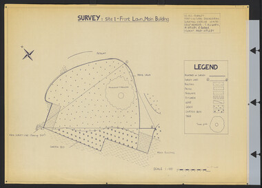
Plan, Survey: Site 1 - Front Lawn, Main Building, 1985
Plan of Front Lawn area with legend. V.C.A.H - Burnley Horticultural Engineering Surveying Exercise dated 10.09.1985. Group Members: T. Allworth, M. Appleby, B Barker (Student: Mary Appleby). Scale 1:100.vcah, lawns -
 Kiewa Valley Historical Society
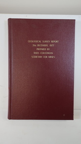
Book - Geographical Survey, Geographical Survey Report 31st Dec. 1977 prepared by Thos. Couchman Secretary for Mines
Office of Mines published progressive reports on the Geological Survey of parts of Victoria.This book includes a chapter on 'Dargo and Bogong' Pages 96 - 117 and includes a fold out map of this area. These pages show heavy use.Hard deep red cover with gold printed title located at the centre top. Bound with spine blank. 217 pages. Date 1878 First chapter and some pages have pencil marks including page 97.geological survey 1878, dargo, bogong -
 Federation University Historical Collection
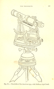
Book, Bennett H. Brough, A treatise on Mine-Surveying, 1904
The author, Bennett H. Brough was an associate of theRoyal School of Mines, a member of the COuncil of the Institution of Mining Engineers, a fellow of the geological society and of the Institute of Chemistry, a member of the Mining Institute of Cornwall, and a former instructor of mine-surveying at the Royal School of MinesRed had covered book 372 pages - part of Griffin's Mining Series. Contents include general explanatinos of surveying, an historical sketch, mineral deposits, mining terms, measures of length, measurement distances, the chain, rods, steel bands, measuring wheel, Miner's Dial, Magnetic needle, Fixed needle, German Dial, theodolite, traversing underground. Surface-surveys. plotting the survey, calculation of area, leveling, Telescope, Setting out, Mine-Surveying Problems, Mine Plans, Photographic Surveying, examination Surveying. Illustrations include: Whitelaw's Dial (Fig 22), Theodolite of the American Type with Hoffman tripod head, (fig 37a)mining, surveying, miner's dial, chain, survey, theodolite, scientific instruments -
Canterbury History Group
Article, Don Gibb, The Elgar's Special Survey
Copy of a talk given by Don Gibb to the Canterbury History Group in June 2015 on the Elgar Survey which will be the basis of the second chapter of his forthcoming book on the social history of Canterbury. Includes maps and a list of the first Boroondara ratepayers.canterbury, mcwilliam. gwen, land subdivision, port phillip district, maps, gibb> don -
 Bendigo Military Museum
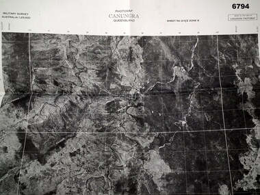
Map - MAP, CUNUNGRA, QLD, Royal Aust. Survey Corps, 1955
Canungra was the Jungle Warfare Training Centre (JTC) before and including 1968. Item in the collection re Lt.Col. Swatton refer Cat No 6719.2P for his service details.This is a full size air photo map. It is black and white. Some natural features are labelled with white printing. The air photo has a white border of approx 6.5 cms size. Map information is printed in black ink around all four borders.Map data = Military survey Australia 1:25,999 Sheet No. 213/2 Zone 8. Scale 1:25,000. Date = The air photo was taken Jan 1955. Map produced by R.A. Survey Corps 1955.passchendaele barracks trust, survey map -
Federation University Historical Collection
Book, Jacobs Lewis Vines Architects and Conservation Planners, Historic Sites Survey: Ballarat Study Area, 1980, 1980
This survey was commissioned by the Land Conservation Council, Australian Heritage Commission and the Ministry for Conservation 114 page report on historic sites in the Ballarat region. It includes information on sites, a schexdule of sites, silte selection and designated areas (ie around towns)historic sites, ballarat, wendy jacobs, miles lewis, gary vines, berringa, buninyong, creswick, dunnstown, fiery creek, lal lal, langi logan, cathcart, mount cole, mount egerton, nerrina, gong gong, wombat state forest, railways, explorers routes, early roads, land conservation council, ausralian hertiage commission, department of planning, icomos (burra) charter, nigel lewis, richard aitken, freehold land, public land, langi ghiran, new jubille mine, birthday tunnel mine, pitfield plains, smythesdale, buninyong company, mount clear, mt clear, canadian gully, warrenheip distillery, thomas mitchell, waterloo, trawalla, beaufort, raglan, internment camps, forestry, mining, mining, mt egerton, mary hollick collection, jubilee mine, burra charter, historica areas data form, explorers, egerton company, black horse mine, mt egerton government battery, kaolin mines, anderson brothers, barkstead, anderson's tramway, clarkesdale, berry leads, birthday tunnel mine berringa, warrenheip, australasian company, mount mercer, lanvi-kal-kal, water race -
 Melbourne Tram Museum
Document - Report, Melbourne & Metropolitan Tramways Board (MMTB), "Survey of Passengers April 1974 - first Z3 tram in service", 25/09/1979 12:00:00 AM
Photocopy of an A4 page with hand written headings, titled "Survey of Passengers April 1974 - first Z3 tram in service", giving response to the questionnaire completed by 110 passengers and comments received. Signed R. Dunning? 25-9-1979.trams, tramways, z3 class, surveys, new trams -
 Melbourne Tram Museum
Document - Memorandum, Peter Spruch, Carolyn Cleak, "Result of PTC Uniform Survey", mid 1990's
Photocopy of a two single A4 sheets, titled "Result of PTC Uniform Survey", carried out by Driver Peter Spruch and Driver Carolyn Dean, mid 1990's?. Gives the view of the respondents of both male and females on the then current uniforms.trams, tramways, employees, uniforms, surveys -
 Bendigo Military Museum
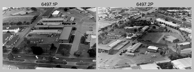
Photograph - Military Establishments located in South Australia, c1986
This is a set of 20 oblique angled photographs of military establishments located in South Australia circa 1986. 4th Field Survey Squadron located in Keswick Barracks Adelaide, features in photos .1P to .6P. Warradale Barracks, Adelaide features in photos .7P to .10P. Woodside Barracks features in photos .11P to .14P. The military establishment featured in photos .15P to .20P is unknown.This is a set of 20 oblique angled photographs of military establishments located in South Australia circa 1986. The black & white photographs are on 35mm negative film and are part of the Army Survey Regiment’s Collection. The photographs were scanned at 96 dpi. .1) to .6) - Photo, black & white, 1986. Keswick Barracks, Adelaide, SA. .7) to .10) - Photo, black & white, 1986. Warradale Barracks, Adelaide, SA. .11) to .14) - Photo, black & white, 1986. Woodside Barracks, SA. .15) to .20) - Photo, black & white, 1986. Unknown location, SA. .1P to .20P – ‘Keswick, Warradale and Woodside’ annotated on negatives sleeve.royal australian survey corps, rasvy, 4 fd svy sqn -
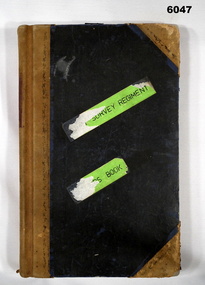 Bendigo Military Museum
Book - Army Survey Regiment , Visitors Book, Jan 1975 - Februrary 1996, Jan 1975
A record of visitors to the Army Survey Regiment 13 Jan 75 - 6 Feb 96Visitors Signature Book, 13 Jan 75 - 6 Feb 96. Hard covered, Leather bound, greenroyal australian survey corps, rasvy, fortuna, army survey regiment, army svy regt, asr