Showing 1867 items
matching town centre
-
 Kiewa Valley Historical Society
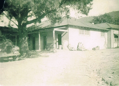
Photograph Tawonga Hotel, Tawonga Hotel Circa 1940s - 1950s, circa 1940s to 1950s
This photograph shows the "lay back" atmosphere enjoyed in a small country town in the 1940s to the 1950s. Two women and a young boy basking in the warmth of the sun. The unsealed drive way and cars parked close to the entrance was typical of small towns during this period. Open doors and shady trees provided sufficient cooling for most sunny days. The wooden barrel next to the outside wall shows that storage space within the hotel was limited and that metal aluminium barrels had not been in existence. This photograph was taken at a time when children and women had limited access to the major drinking and entertainment facilities within a hotel(pub). Legal drinking age was for patrons 21 years and older and no strict dress codes where applied. The hotel bar was not open on Sundays (God fearing) and opening time restrictions were in place. "In transit" clients were given some leniency when staying in small country hotels as strict liquor laws This photograph presents a window to a life in the 1940s to 1950s, of a small town in the Kiewa Valley. It covers a period when the local hotel or "pub" was the meeting point for local men and women to talk about local events and life in general. It was also a point where "locals' had the first opportunity to meet new arrivals and converse with tourists and "through traffic". The importance of "face to face" verbal communication was a critical part of community life and interaction. The hotel(pub) was in this period the hub of small communities, and together with local churches provided the essential structure for a balanced existence in rural Australia.Black and white photo of Tawonga Hotel. This photo is in itself a photo of a photo and as such lacks fine detail. This reproduction is on "Kodak XtraLife II paper ""outback" hotels, pubs, rural short stay accommodation, tawonga hotel -
 Kiewa Valley Historical Society
Photograph of Lake Guy and Bogong Village, Lake Guy and Bogong Village, Approx. 1945
In 1940 Field Headquarters for the Kiewa Scheme were established at Bogong with office, workshop facilities and accommodation for workmen, staff and some families constructed. (There had been a 'tent camp' on this site in 1939 but was destroyed by bushfires) Construction of accommodation continued until 1947. A total of 40 houses plus a hostel for single staff, post office, police station, medical centre and primary school all with water and sewerage and electricity supply. The staff hostel was known as Kiewa House and is now occupied by the Education Department. Lake Guy was named after Mr. L.T. Guy who was the Resident Engineer in charge of construction work and associated activities on the Kiewa area. He held this position from 1939 to November 1946 when he was transferred to Head Office.This photograph is an excellent historical record of Bogong Village in about 1945. It shows the layout of the town in the fairly steep terrain, the workmen's camp between the houses and the lake foreshore, the Commissioner's Lodge on the hill behind the Village, the walkway through the dam wall can be seen to the left of the spillway, the dam is on spill and note damage to the large trees is still evident from the 1939 bush fires. The Commissioner's Lodge was lost in the 2003 fires and the camp buildings were in service until 1962, when they were removed and the site converted into a public picnic area with lawns and gardens.A Black and white photograph"Lake Guy and Bogong" hand written on back of photograph.kiewa, accommodation, lake, dam, bogong -
 Kiewa Valley Historical Society
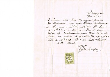
Letter Commerce, Confirmation of Payment, 02/12/1911
This document (dated 1911), is a receipt covering the compensation for the three acres of land required to establish the Tawonga School from its original site (since 1880) to a more central site (since 1911), within the township. This receipt clearly shows the era in which the community involvement and social commitment of landholders was at a higher level, in the early 20th century, than at the latter part. Matters involving community welfare in relatively isolated rural regions was of high priority to every person whether town folk or grazier/farmer or miner. The letter of acceptance of the amount of twenty one pounds for three acres was signed by John Cooper on behalf of Ada Ryder (parent at the school), did not require State Government Compulsory Acquisition process (as it may have, had it been in the latter part of the century and if it were in a city or large town. This social benevolency was part of the period (up to the late 1900's) of the rural Australian environment. This was well before international land investments changed the picture of the socio-economics of country towns.A4 letter of confirmation of payment on pre-lined paper and with a margin. Both margin and lines are coloured in light grey. The page has been folded four times and shows faintly, horizontal lines, of manufacture. The letter is framed with a glass front.This receipt for the compensation of money is hand written in ink and reads: "Tawonga Dec 2 1911, I have this Day Received from the Residents and other People interested in the new State School the Sum of (Pounds sign) 21-0-0 twentyone Pounds being value of compensation for three Acres of land on which is erected the new State School No.2282 Paid by Cash & Cheques with thanks 2/12/11 (Signed) John Cooper" Below this is affixed a Victoria 1 pence stamp duty stamp, on which is written(freehand) Paid 2/12/11 Initialed J Cfinancial letters, receipts, school acquisitons, stamp duty -
 Kiewa Valley Historical Society
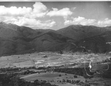
Photograph of Kiewa Valley Panorama, Kiewa Valley from No. 5 Road, Before 1945
In 1943 a camp for workmen was erected and a commencement made with the erection of plant storage and workshop buildings in the new township of Mt. Beauty. The photograph was probably taken after the completion of these buildings. There is no sign of construction of the town itself. In the latter part of 1945 work was commenced on the Mt. Beauty township area with a medical centre, general trading store and some houses under construction. The No. 5 Road, from where the photograph was taken, is the road to West Kiewa Power Station and Big Hill Scenic Lookout.Is an excellent view of the Kiewa Valley before there was little work undertaken to establish the town of Mt. Beauty. Farming was well established with the evidence of huge areas of cleared land. The junction of the East and West Kiewa Rivers can be clearly seen. The first Workmen's camp is near the river and some workshop buildings can also be seen. Black and white photograph of the Kiewa Valley, looking North.Handwritten on the back of photograph "Kiewa Valley from No. 5 Road".kiewa valley, camp, buildings, mt. beauty -
 Kiewa Valley Historical Society
Photograph of Mt. Beauty, Mt. Beauty from transmission line, Approx 1950/51
This photo is of the very newly constructed State Electricity Commission town of Mt. Beauty. The houses up to Nelse street were erected from 1946 onward and then the township was extended beyond Nelse Street in 1950 which places this photograph about 1950/51. There is no evidence of work being commenced on the regulating pondage but the tail race canal can be seen on the centre right of photo. The workmen's camp was enlarged in 1950 to the extent of providing accommodation for a total of 1,200. There are a number of dwellings on Simmonds Creek and the road to Falls Creek can clearly be seen. Snow capped Mt. Bogong is in the upper left of the photo with Mt. Beauty behind the township rising to Big Hill beyond that.Shows the newly constructed town of Mt. Beauty surrounded by farmland and before the regulating pondage was built to discharge water from the power stations via the West Kiewa tail race tunnel into the Kiewa River. Black and white photographHand written on back of photograph "Mt. Beauty from Transmission Line"mt. beauty, construction, pondage, state electricity commission -
 Kiewa Valley Historical Society
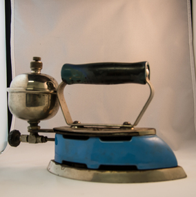
Iron Hand Kerosene, mid to late 1900s
The 1950's saw a revolution in small appliances for use in the average household. This hand held self heating(kerosene) iron was introduced as a time saving and more convenient iron for pressing clothes and other cloth fabrics. It replaced irons needing a separate fire source to heat the ironing plate. These irons continued to be in service, even when electricity was available in cities and larger rural towns (domestic electric steam irons were invented in 1938). This item was used before and during the electricity supplies available from the Kiewa Hydro Electricity Scheme. These irons remained in use within regional rural areas that had limited or unreliable electrical reticulation.In the 1950s and later the Kiewa Valley was still a relatively isolated region which was home to rural properties and small settlements. The availability of electricity and or the financial means to afford new types of electric hand irons ensured that older and sometimes less efficient ironing remained for an extended period covering the 1960s to 1970s. Kerosene products, such as this kerosene iron was a cheaper method for farm based domestic and other rural activities requiring a heat source. The use of kerosene as a heat/light source was able to be supplied in bulk and able to be used when floods severed vital roads into this region. The supply of electricity was in summer time subject to interruption from bush fire damaged wooden poles carrying the electrical cables. Self sufficiency by rural populations was the backbone of survival and the ability to store energy sources "on the farm" was a prerequisite of isolated regions, such as the Kiewa Valley, circa 1950s.This Coleman kerosene iron has a solid steel chrome plated(press) base with a painted (blue) wooden handle. The handle is stud fastened onto an oblong shaped rolled steel handle frame and screwed (two screws) onto the base plate. Both the heating plate and the top securing plate are shaped similar to a river boat. The main housing enclosing the heating element is enamel coated(blue in colour) steel and has a half hole for lighting the kerosene at the rear end. Behind the handle and protruding upwards is a stainless steel fully enclosed container (bowl shaped) for the main supply of kerosene to the burner or generator(enclosed within the main body of the iron. The bowl has an air valve and inlet for pressurised air intake (hand pump) On the bottom rear of the fuel bowl there is a screw regulated fuel pump. The fuel heated base plate provides the heat for this advertised "self heating iron(instant lighting). See KVHS 0347B- Instruction sheet; KVHS 0347C- Wrench; and KVHS 0347D Fuel can.Stamped on the base plate of the handle, front region "COLEMAN LAMP & STOVE CO." below this "WICHITA KAN" below this"TORONTO CAN". In the middle of the handle base and in larger print "COLEMAN Instant-Lite" At the rear location in large print "MODEL 4" in smaller print below "MADE IN U.S.A." below this "PAT#1718473"household appliances, alternative non electrical ironing appliances, domestic appliances, kerosene appliances -
 Kiewa Valley Historical Society
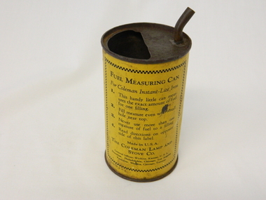
Can Fuel Measuring, circa 1950
The 1950's saw a revolution in small appliances for use in the average household. The hand held self heating(kerosene) iron for which this filling can was provided ,was introduced as a time saving and more convenient iron for pressing clothes and other cloth fabrics. It replaced irons needing an external fire source to heat the ironing plate. These irons continued to be in service, even when electricity was available in cities and larger rural towns. This item was used before and during the electricity supplies available from the Kiewa Hydro Electricity Scheme. These irons remained in use within regional rural areas that had limited or unreliable electrical reticulation and the ability to service them from this filling can was an essential part.n the 1950s and later the Kiewa Valley was still a relatively isolated region which was home to rural properties and small settlements. The availability of electricity and or the financial means to afford new types of electric hand irons ensured that older and sometimes less efficient ironing appliances remained for an extended period covering the 1960s to 1970s. Kerosene products, such as the kerosene self heating (KVHS 0347A) iron and this kerosene filling item, was a cheaper method for farm based domestic and other rural activities requiring a heat source. The use of kerosene as a heat/light source was able to be supplied in bulk and able to be used when floods severed vital roads into this region. The supply of electricity was in summer time subject to interruption from bush fire damaged wooden poles carrying the electrical cables. Self sufficiency by rural populations was the backbone of survival and the ability to store energy sources "on the farm" was a prerequisite of isolated regions, such as the Kiewa Valley, circa 1950s.This specially spout fitted can was provided with the Coleman self heating kerosene iron (see KVHS 0347A). On one side of the half enclosed top of the can there is a small spout(for poring the appropriate liquid into the egg shaped fount container) at the rear end of the hand iron. The can is made from tin. See KVHS 0347B- Instruction sheet; KVHS 0347C- Wrench.On one side of the can in black print on yellow background is "FUEL MEASURING CAN" underneath is "For Coleman Instant-Lite Iron" underneath are four numbered paragraphs detailing the use of this can. Below this is the name and places of manufacture. On the other side of the can is printed "BE SURE" with filling and maintenance instructionskerosene can, ironing, domestic appliances, household appliances -
 Eltham District Historical Society Inc
Magazine, Sun News-Pictorial, Bush Fires: A pictorial survey of Victoria's most tragic week, January 8-15, 1939
THE WEEK REVIEWED (Article; Bush Fires: A pictorial survey of Victoria's most tragic week, January 8-15, 1939. Published in aid of the Bush Fire Relief Fund by the Sun News-Pictorial in co-operation with its newsagents, pp2-3) THE fiercest bush fires Australia has known since its discovery are quiescent at the moment, and Victoria, in the comparative coolness of the change which came with rain on Sunday night, has begun·to count its losses. In the fiery eight days, from Sunday to Sunday, at least sixty-six men, women and children have lost their lives in forest fires, or have succumbed to burns and shock; many others have died from heat; and several serious cases of burns are being treated in hospitals. Two babies in Narrandera district have died, and ten others are in hospital, because of milk soured by the record temperatures of those eight days. Forest damage totals at least a million pounds, and incalculable damage has been done to the seedlings which were to have been the forests of the future. Water conservation will be seriously affected by the silting-up of reservoirs and streams from which protective timber has been taken by the all-engulfing flames. More than a thousand houses have been destroyed, and these, with 40 mills, and schools, post-offices, churches, and other buildings, represent a loss of at least half a million. At least 1500 are homeless. For their aid, money raised in appeals has now passed the £50,000 mark, and the biggest relief organisation ever set up in peace time has swung into operation. The First Hint Victoria's first hint of what was to come appeared on Sunday, January 8, when most parts of the State awoke to find a blistering day awaiting. At 12.20 p.m., when the thermometer reached its highest for the day, 109.6 degrees, the first fire victims were at that moment going to their death on a bush track five feet wide off the main road to Narbethong. They were the forestry officers Charles Isaac Demby and John Hartley Barling, who went to warn Demby of his danger when he parted from his companions, and was himself surrounded by the treacherous fire. It was not until 8 o'clock next morning that the tragic news was flashed throughout the State. Searchers found the two charred bodies close together, one seeking protection in the nook of two logs. Barling's watch had stopped at 1.20. In the meantime, tragedy was spreading its cloak. By Monday, big fires were raging at Toolangi, Erica, Yallourn, Monbulk, Frankston, Dromana, Drouin South, Glenburn, and Blackwood, with smaller outbreaks at many other centres. In the ensuing week, while women and children were evacuated as fast as the flames would permit, Erica-scene of the 1926 fire disaster-thrice escaped doom by a change of wind. Indeed, those who have been in the fire country these past days say that the numbers of times a change of wind has saved towns from destruction is amazing. In the towns they speak of miracles. Monday's Miracles The escapes from Monett's Mill at Erica and from the Hardwood Company's Mill at Murrindindi, near where Demby and Barling went to their death, were Monday's miracles. Twenty came out alive from each mill. At the first a 60ft. dugout provided an oven-like refuge; at the second, 12 women and children survived in the smoke-filled gloom of a three-roomed cottage while their eight men, their clothes sometimes afire, poured water on the wooden walls. Three houses out of ten remained when the fire had passed. Record Temperatures Sunday had been the hottest Melbourne day for 33 years; Monday dropped to a 76.1 degree maximum; but Tuesday dawned hotter than ever, the mercury reaching 112.5. By now rumor was racing ahead of fact; whole towns were being reported lost; the alarm was raised for scores of missing persons. But fact soon overtook rumor, and within a few days the staggering toll began to mount to a figure beyond the wildest imaginings of the panic-stricken. Six died from heat on this torrid Tuesday, and the fires spread in a wide swathe from south-west to north-east across the State. Fish died in shallow streams. A curtain of smoke hid the sky from all Victoria, and hung far out to sea. It alarmed passengers on ships. On the Ormonde, on the voyage to Sydney from Burnie, women ran on deck, believing fire had broken out in the hold. Days later the smoke reached New Zealand. In Melbourne thousands of fire-volunteers were leaving in cars: vans, motor-buses-anything reliable on wheels-to aid the country in its grim fight. In the fires at Rubicon and. Narbethong, seventeen were facing death this day. But not till Wednesday, when Melbourne breathed again in a cool change, while the country still sweltered in temperatures up to 117 degrees, did the news come through the tree blocked roads. A woman and her little daughter, trapped on the road, were among those who died. Their bodies, and those of menfolk with them, were found strewn out at intervals along the road, where the furnace of the surrounding fire had dropped them in their tracks as they ran. Twelve died at a Rubicon mill, five on the road at Narbethong. At Alexandra, not far distant, a baby was born while the fires raged, and stretcher-bearers brought in the injured. On Thursday the State Government voted £5000 for the relief of fire victims. The Governor (Lord Huntingfield) and the Lord Mayor (Cr. Coles) visited some of the stricken areas, and dipped into their pockets personally. Later, the City Council, too, voted £5000. Friday, The 13th Friday, the Thirteenth, justified its evil name. A blistering northerly came early in the morning, presaging destruction, and forcing the mercury to a new record of 114 degrees. Racing fires killed at least ten in those terrible 12 hours. Four children were engulfed in the furnace at Colac. Panic drove them, uncontrollable, into the smoke-filled road when the fire raced down behind their home. They choked to death. In other parts fires were joining to make fronts of scores of miles. Kinglake was being menaced on two fronts, £60,000 worth of timber was going up in smoke in Ballarat district. Warburton was surrounded. Residents at Lorne, favoured resort, were being driven to the sea-front by a fire which destroyed at least 20 homes. Healewille. with flames visible from the town at one stage, was in a trough between two fires which burned four guest-houses, seven homes and left its surrounding beauty-spots wastes of bowed-over, blackened tree-fern fronds; with its famous Sanctuary, however, intact. Most of Omeo was destroyed this black day: Noojee. while 200 residents crouched in the river, was being reduced to a waste of buckled iron and smoking timber; Erica was once again saved by a change of wind. Beneath a pall of smoke, the Rubicon victims were buried at Alexandra. Friday night and the early hours of Saturday saw the streets of beleagured towns strewn with exhausted fire-fighters. Their flails beside them, ready for the next call, they lay where exhaustion overtook them-on footpaths, beside lamp-posts, in gutters, in cars, under trucks. Saturday's dawn brought clear skies and lower temperatures in many parts, and from the burnt-out areas came a great rush of tragic reports. The death-roll rushed past the fifty mark with incredible speed. Some had been trapped on roads, others at mills; some, after burying their treasures, had clung too long to the places they had made their homes for many years. Four men lost their lives because one went back for his dog. By Sunday, when the first of the saving rain came, nearly another score of names had been added to the list.Newspaper magazine, 48 pages (incl. covers). Fully digitised and searchable PDFPublished in aid of the Bush Fire Relief Fund by the Sun News-Pictorial in co-operation with its newsagents.bushfires, 1939 bushfires, black friday, warrandyte -
 Eltham District Historical Society Inc
Photograph, George W. Bell, Diamond Creek, 1969
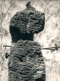
Canberra Times (ACT : 1926 - 1995), Thursday 9 January 1969, page 1 A day of century heat, 13 KILLED IN VICTORIAN FIRES ...About thirty houses and a public hall were destroyed by fire in the township of Diamond Creek. The group officer of the Diamond Creek Fire Brigade, Mr Tom Harrington, said tonight that he thought it was a "miracle" that no-one lost their lives in the fires. A relief centre for the homeless was set up by the Diamond Valley Shire Council. Mr Harrington said that the first fire call in the town was received at 10.45 am. "Within 20 minutes there were five more fires and it seemed like the whole town was alight", he said. "It was a chaotic day. All our best plans for fighting the fires became disorganised. "As 60-mile-an-hour winds swept fires through different parts of the town many fire fighters were unable to get from one fire to another. ," Black and white photograph of charred fire remnant Diamond Creek 1969diamond creek, fire, george w bell collection, bushfire, charred, burnt timber -
 Warrnambool and District Historical Society Inc.
Book, Streets of Hamilton, 2007 (revised and reprinted 2009)
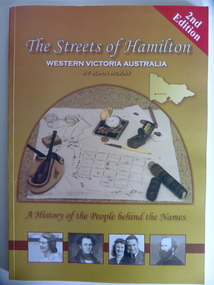
This is a book providing information on the streets of Hamilton, Victoria and the origin of the names. Hamilton is a city in Western Victoria at the intersection of the Glenelg Highway and the Henty Highway. European settlement began with the arrival of pastoralists following the 1836 explorations of Major Thomas Mitchell. The Wedge family in 1839 had the property ‘The Grange’ which covered the site of Hamilton today. The town was gazetted in 1851 and named after a place in Scotland. Hamilton Victoria is the centre of a sheep-grazing and agricultural district. The book won an award in the 2008 Victorian Community History Awards. This book is of interest as it gives information on the Hamilton streets and the origin of their names. The history of Hamilton is of particular interest to those also living in the Western District. The book will be a useful research tool. This is a soft cover book of 174 pages. The back cover has a white background with black and white photographs of five local Hamilton people. The front cover has a yellow and brown background with black and white photographs of five local Hamilton people, an outline of a map of Victoria and a photograph of a map of the Hamilton area with some artefacts placed on the map. The book contains an Introduction, a Preface, a Foreword, an Early Days Overview, a list of Contents, a list of the streets in alphabetical order with information on the origin of the names, two Appendices and an Index. The book has many black and white photographs and sketches. Front Cover: ‘2nd Edition’ ‘The Streets of Hamilton’ ‘Western Victoria Australia’ ‘By John McKay’ ‘A History of the People behind the Names’hamilton, victoria, john mckay, street names of hamilton, warrnambool -
 Victoria Police Museum
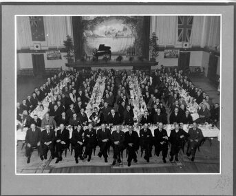
Photograph (Victoria Police), Police Officers on dinner event, February 1945
[see inscriptions] Black and white mounted photograph. Approximately 160 men (171 according to inscription on the back) sitting on large tables at a formal dinner event; all weatinh suits and posing for photograph. Photo was taken in a large rooom with a stage, Malvern Town Hall accoring to inscriptions on the back - tables occupy centre and front of photograph - but in the background: [left] Australia flag, WWII poster; [center] stage with painted landscape and piano; [right] WWII poster and Britain flag. [information of event on newspaper cutting stuck on the back - as described on Inscriptions]Handwritten: 171 PRESENT // FEB 1945 // (?) OFF SUPT KNOTT // INSPT SAMBLEBE // CONST GRAMBEU /// MALVERN TOWN HALL Newspaper cutting glued to frame: Supt. J. R. H. Knott, has rettired from the Police Force after 38 and half years' service, was farewelled by citizens and police officials at Malvern Town Hall on Tuesday night, The mayor of Malvern (Cr. J. Johnson) presided and presented SUpt. Knott with a chair and a wallet of notes. Similar presentations were made to Inspector C.H.D. Samblebe and First Constable O. Grambau, who have also retired. Supt. A.D. McKinnon of Ballarat will succeed Supt. Knott // handwritten: SUN 1/2/45victoria police museum, police officers, police academy, police force, superintendent mckinnon, superintendent knott, cr johnson, inspector samblebe, first constable grambau, poulter, william -
 Warrnambool and District Historical Society Inc.
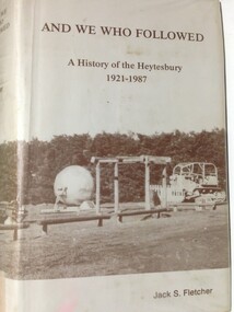
Book, And We Who Followed, 1988
... Settlement Scheme and is today an important dairying area centred... an important dairying area centred around the town of Simpson ...This book contains a history of the Shire of Heytesbury from 1921 to 1987. It is written by Jack Fletcher and follows on from his book ‘The Infiltrators’ which is the history of the Heytesbury region from 1840 to 1920. The Heytesbury area in the Western District of Victoria was named after the village of Heytesbury in England and the first Baron Heytesbury, Sir William A Court, who purchased the village in 1828 and was a distinguished public figure in Great Britain at the time. The area, largely forested, was cleared in 1960 to establish the Heytesbury Soldier Settlement Scheme and is today an important dairying area centred around the town of Simpson.This book is of some interest as it details a history of an area adjoining the Warrnambool district. The Heytesbury Settlement farmers are predominantly dairy producers, similar to those in other districts around WarrnamboolThis is a hard cover buff-coloured book with a dust cover sealed down onto the hard cover. The front and back covers have a sepia coloured photograph of the Heytesbury Settlement Park.Front of dust cover – ‘And We Who Followed - A History of the Heytesbury 1921-1987-Jack S. Fletcher Spine – as above (plus a library classification) heytesbury region, victoria, heytesbury soldier settlement -
 Warrnambool and District Historical Society Inc.
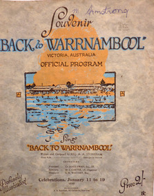
Programme - Back to Warrnambool 1930 official souvenir program, January, 1930
This booklet contains the Program for the Back to Warrnambool Celebrations for 1930. It contains a brief history of the town and photos of current council Office bearers and local scenic spots. There is also a map of the town and a large number of advertisements for local businesses. Back to Warrnambool celebrations were an important event on the social calendar and were run over a number of years in the town. This program is one glimpse into the city and its people in 1930. Some of the events held over the week included processions, sports Carnivals, concerts, card playing, Church services and local tours. Many of the advertisements are for businesses of long standing and importance to the prosperity of the town. Twenty page Booklet with light card, grey, mottled cover. Text in brown and blue. Picture of Warrnambool main beach in centre. Price 2/- in bottom right corner. Back cover has full page advertisement for Bruce and McClure. Text and illustrations are brown. M Armstrong is written in blue biro on top right corner. Song “Back to Warrnambool,” written and composed by Reg A.A. Stoneham,” is printed below picture on front cover. Published by A.A. Stoneham, 241 Carlisle St, Balaclava.younger pty ltd, warrnambool, back to warrnambool, 1930, souvenir program, warrnambool cordials, morse pty, swinton, warrnambool cheese and butter factory, batros shoes, tattersalls hotel, bruce and mcclure, warrnambool woollen mill, reg a. a. stoneham -
 Warrnambool and District Historical Society Inc.
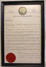
Letter - Citation City of Warrnambool Hayward, 1985
Cyril and Joyce Hayward migrated from England in 1955 and quickly became involved in the Arts in Warrnambool. They both became life members of the Warrnambool Theatre Company. Mrs. Joyce Hayward along with her husband Cyril, had a 30 year association with the Warrnambool Theatre Company. They acted, directed and produced a number of works from the 1950’s through to the 1980’s. Mrs. Hayward taught drama and speech at Warrnambool High School and St Ann’s College. They both worked towards reviving the Warrnambool Arts Council.. They were involved in Christ Church choir, readings for the blind, Probus and Penguin club. They retired to Bribie Island in 1985. Joyce Hayward died aged 97 in 2007.Joyce and Cyril Hayward played a significant part in the development of the Performing Arts and Education in Warrnambool over a 30 year period. They both received the Warrnambool Citizenship award. This letter expresses the gratitude of Council and citizens of Warrnambool to the Haywards for their contribution. Cream paper with body of letter typed and signed by the Mayor, a councillor and Town Clerk at the time. It has the City of Warrnambool crest at the top in light and dark blue with gold lettering and at the bottom left corner is the City of Warrnambool seal in red.Cr R.K. Patterson, Cr T, A, McCormack, V. G. Robson, Town clerk. warrnambool, cyril hayward, joyce hayward, citizen award, performing arts centre. -
 Warrnambool and District Historical Society Inc.
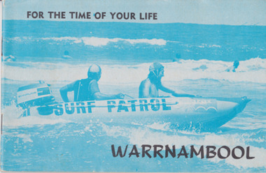
Booklet, For the time of your life Warrnambool, 1975
Tourist brochures have been produced in Warrnambool since the 1890s and this one has been published by the Warrnambool Chamber of Commerce and Industry. Some of the photographs for this brochure come from the Warrnambool Standard newspaper and the information on the car tours was provided by the Warrnambool Tourist Information Centre. Tourism in the Warrnambool region has always been of major importance to the town/city and a local Chamber of Commerce or Tourists’ Association has been active in the area for over 100 years. Today the official tourist guides are produced by the Warrnambool City Council. This brochure is a good example of local tourism promotion in the 1970s and will also be useful for display. This is a small booklet (1975) containing 39 pages. It has local Warrnambool advertisements, maps, photographs, printed material and details of 9 tours that tourists could take by car around Warrnambool. The pages are stapled. The front cover has a blue-tinged image of a surf boat patrol and the back cover has a black and white photograph of Warrnambool’s beach. There is one loose page with a summary of the tourist spots in Warrnambool and a map. Front Cover: ‘For the Time of Your Life – Warrnambool’.tourism in warrnambool, warrnambool -
 Warrnambool and District Historical Society Inc.
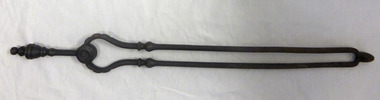
Tool - Fireside implements, 000190.1 Shovel : 000190.2 Tongs
Initial court cases for the Western district were held and controlled for some time by Rutledge in Port Fairy. The first courthouse was built around 1854 and was in service until the stone building was built next to it in 1870. These two implements were used until around 1970 when heating was installed in the courthouse. They were decommissioned by Mr Ellis Roberts, Public Works Department Inspector.These implements have a strong connection to a public building which has a long association with the town and surrounding area. The courthouse of 1863 was the scene of an infamous murder of Constable O’Boyle in front of the fireplace. Shovel has barley sugar twisted handle with eight sided domed top. It is flared at the bottom to hold the spade which is attached with two metal rivets. Spade contains a number of holes cut into oval shape in centre and has fluted side edges. The tongs consist of two parts held together below a short handle with a metal rivet and two metal discs. Both pieces have decorative mouldings on the handles and remnants of black paint. warrnambool courthouse, fire tongs, fire shovel, fire spade, warrnambool -
 Orbost & District Historical Society
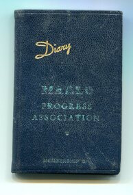
Document - diary, 1946
The association was formed as a means of giving Marlo residents a voice with the then Orbost Shire Council. It has continued as the Marlo Ratepayers & Residents association.This is associated with the history of Marlo which is a small town which has a close association with Orbost. Marlo sits at the mouth of the Snowy River and was the port for Orbost. It came under the Orbost Shire Council. A small dark blue covered diary with "Diary" in gold print written diagonally across the top and in the centre "MARLO PROGRESS ASSOCIATION" in light green print with "MEMBERSHIP 5/-" in light green print underneath. It is unused.marlo, east gippsland, coastal communities, orbost shire council, progress association, memberships -
 Ringwood and District Historical Society
Picture, A. K. Lines MacFarlane & Marshall Architects & Town Planners, 562 StKilda Rd Melbourne Drg.No.6615-43, Artist's impression of proposed Ringwood Civic Centre, May-68
Artist's impression of proposed Ringwood Civic CentreRingwood Civic Centre Perspective -
 Ringwood and District Historical Society
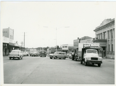
Photograph, Maroondah Highway outside Town Hall
Street scene looking west between Railway Station and Wantirna Road, including ANZ Bank, Coles Stores, State Bank, Midway Arcade, Jack Wilson - Removalist, Ringwood S.E.C., Ringwood Lamb Centre, c.1965 -
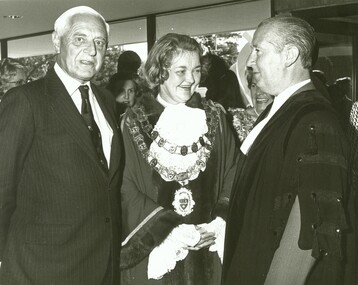
 Ringwood and District Historical Society
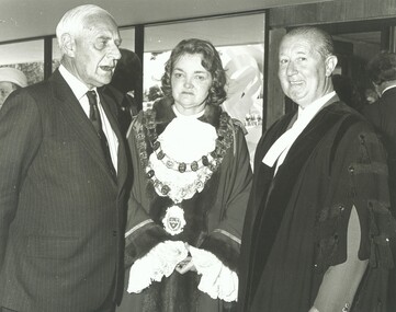
Photograph, Official opening of the Karralyka Centre, Mines Road, Ringwood on 19/4/1980 - L-R: Victorian Governor Sir Henry Winneke, Cr Pat Gotlib (Mayor), Arthur W Hall (Town Clerk), 19-Apr-80
Official opening of the Karralyka Centre - L-R Sir Henry Winneke, Cr Pat Gotlib (Mayor), Arthur W Hall (Town Clerk). +Additional Keywords: Winneke, Sir Henry (Governor of the State of Victoria) / Gotlib, Pat (Cr) / Hall, Arthur W. (Town Clerk) -
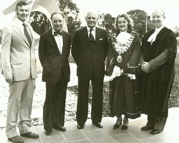
 Ringwood and District Historical Society
Photograph, Official opening of the Karralyka Centre, Mines Road, Ringwood on 19/4/1980 - L-R: Victorian Governor Sir Henry Winneke, Cr Pat Gotlib (Mayor), Arthur W Hall (Town Clerk), 19-Apr-80
Official opening of the Karralyka Centre - L-R Sir Henry Winneke, Cr Pat Gotlib (Mayor), Arthur W Hall (Town Clerk). +Additional Keywords: Winneke, Sir Henry (Governor of the State of Victoria) / Gotlib, Pat (Cr) / Hall, Arthur W. (Town Clerk) -
 Ringwood and District Historical Society
Photograph, Official opening of the Karralyka Centre, Mines Road, Ringwood on 19/4/1980, 19-Apr-80
Official opening of the Karralyka Centre - L-R A.C. Robertson (City Engineer), Harry Seidler (Architect), Sir Henry Winneke, Cr Pat Gotlib (Mayor), Arthur W Hall (Town Clerk). +Additional Keywords: Winneke, Sir Henry (Governor of the State of Victoria) / Gotlib, Pat (Cr) / Hall, Arthur W. (Town Clerk) / Robertson, Alan C. (City Engineer) / Seidler, Harry -
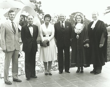 Ringwood and District Historical Society
Photograph, Official opening of the Karralyka Centre, Mines Road, Ringwood on 19/4/1980 - L-R: A.C. Robertson (City Engineer), Harry Seidler (Architect), Lady Winneke - Ellis Fauld (uncertain), Victorian Governor Sir Henry Winneke, Cr Pat Gotlib (Mayor), Arthur W Hall (Town Clerk), 19-Apr-80
Official opening of the Karralyka Centre - L-R A.C. Robertson (City Engineer), Harry Seidler (Architect), Lady Winneke - Ellis Fauld (uncertain), Sir Henry Winneke, Cr Pat Gotlib (Mayor), Arthur W Hall (Town Clerk). +Additional Keywords: Robertson, Alan C. (City Engineer) / Seidler, Harry / Winneke, Lady (uncertain) / Winneke, Sir Henry (Governor of the State of Victoria) / Gotlib, Pat (Cr) / Hall, Arthur W. (Town Clerk) -
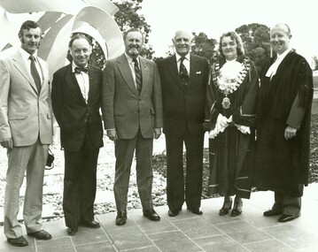
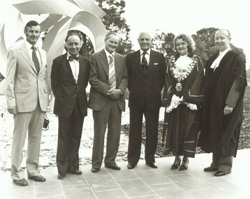 Ringwood and District Historical Society
Photograph, Official opening of the Karralyka Centre, Mines Road, Ringwood on 19/4/1980 - L-R: A.C. Robertson (City Engineer), Harry Seidler (Architect), Cr Jack McRae, Victorian Governor Sir Henry Winneke, Cr Pat Gotlib (Mayor), Arthur W Hall (Town Clerk), 19-Apr-80
Official opening of the Karralyka Centre - L-R A.C. Robertson (City Engineer), Harry Seidler (Architect), Cr Jack McRae, Sir Henry Winneke, Cr Pat Gotlib (Mayor), Arthur W Hall (Town Clerk). +Additional Keywords: Robertson, Alan C. (City Engineer) / Seidler, Harry / McRae, Jack (Cr) / Winneke, Sir Henry (Governor of the State of Victoria) / Gotlib, Pat (Cr) / Hall, Arthur W. (Town Clerk) -
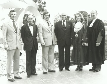
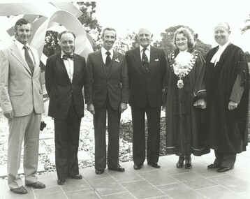
 Ringwood and District Historical Society
Photograph, Official opening of the Karralyka Centre, Mines Road, Ringwood on 19/4/1980 - L-R: A.C. Robertson (City Engineer), Harry Seidler (Architect), Cr Gerald Smart, Victorian Governor Sir Henry Winneke, Cr Pat Gotlib (Mayor), Arthur W Hall (Town Clerk), 19-Apr-80
Official opening of the Karralyka Centre - L-R A.C. Robertson (City Engineer), Harry Seidler (Architect), Cr Gerald Smart, Sir Henry Winneke, Cr Pat Gotlib (Mayor), Arthur W Hall (Town Clerk). +Additional Keywords: Robertson, Alan C. (City Engineer) / Seidler, Harry / Smart, Gerald (Cr) / Winneke, Sir Henry (Governor of the State of Victoria) / Gotlib, Pat (Cr) / Hall, Arthur W. (Town Clerk) -
 Ringwood and District Historical Society
Photograph, Official opening of the Karralyka Centre, Mines Road, Ringwood on 19/4/1980 - L-R: A.C. Robertson (City Engineer), Harry Seidler (Architect), (name unknown), Victorian Governor Sir Henry Winneke, Cr Pat Gotlib (Mayor), Arthur W Hall (Town Clerk), 19-Apr-80
Official opening of the Karralyka Centre - L-R A.C. Robertson (City Engineer), Harry Seidler (Architect), (name unknown), Sir Henry Winneke, Cr Pat Gotlib (Mayor), Arthur W Hall (Town Clerk). +Additional Keywords: Robertson, Alan C. (City Engineer) / Seidler, Harry / Winneke, Sir Henry (Governor of the State of Victoria) / Gotlib, Pat (Cr) / Hall, Arthur W. (Town Clerk) -
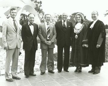 Ringwood and District Historical Society
Photograph, Official opening of the Karralyka Centre, Mines Road, Ringwood on 19/4/1980 - L-R: A.C. Robertson (City Engineer), Harry Seidler (Architect), Cr Alan E Henderson, Victorian Governor Sir Henry Winneke, Cr Pat Gotlib (Mayor), Arthur W Hall (Town Clerk), 19-Apr-80
Official opening of the Karralyka Centre - L-R A.C. Robertson (City Engineer), Harry Seidler (Architect), Cr Alan E Henderson, Sir Henry Winneke, Cr Pat Gotlib (Mayor), Arthur W Hall (Town Clerk). +Additional Keywords: Robertson, Alan C. (City Engineer) / Seidler, Harry / Henderson, Alan E. (Cr) / Winneke, Sir Henry (Governor of the State of Victoria) / Gotlib, Pat (Cr) / Hall, Arthur W. (Town Clerk) -
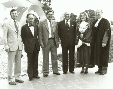 Ringwood and District Historical Society
Photograph, Official opening of the Karralyka Centre, Mines Road, Ringwood on 19/4/1980 - L-R: A.C. Robertson (City Engineer), Harry Seidler (Architect), Cr Frank Corr, Victorian Governor Sir Henry Winneke, Cr Pat Gotlib (Mayor), Arthur W Hall (Town Clerk), 19-Apr-80
Official opening of the Karralyka Centre - L-R A.C. Robertson (City Engineer), Harry Seidler (Architect), Cr Frank Corr, Sir Henry Winneke, Cr Pat Gotlib (Mayor), Arthur W Hall (Town Clerk). +Additional Keywords: Robertson, Alan C. (City Engineer) / Seidler, Harry / Corr, Frank (Cr) / Winneke, Sir Henry (Governor of the State of Victoria) / Gotlib, Pat (Cr) / Hall, Arthur W. (Town Clerk) -
 Ringwood and District Historical Society
Photograph, Official opening of the Karralyka Centre, Mines Road, Ringwood on 19/4/1980 - L-R: A.C. Robertson (City Engineer), Harry Seidler (Architect), Cr W.R. Wilkins, Victorian Governor Sir Henry Winneke, Cr Pat Gotlib (Mayor), Arthur W Hall (Town Clerk), 19-Apr-80
Official opening of the Karralyka Centre - L-R A.C. Robertson (City Engineer), Harry Seidler (Architect), Cr W.R. Wilkins, Sir Henry Winneke, Cr Pat Gotlib (Mayor), Arthur W Hall (Town Clerk). +Additional Keywords: Robertson, Alan C. (City Engineer) / Seidler, Harry / Wilkins, W.R. (Cr) / Winneke, Sir Henry (Governor of the State of Victoria) / Gotlib, Pat (Cr) / Hall, Arthur W. (Town Clerk) -
Ringwood and District Historical Society
Equipment - Printers blocks, Set of 7 Printers blocks showing early Ringwood Buildings 1927-1960, 1927 -1960
Set of 7 printers blocks showing early Ringwood buildings between 1927 and 1960. Town Hall, Old Mechanics Institute and Ringwood East Welfare Centre +Additional Keywords: McGaskill, J.K. / Bamford Bros. / Wilmot Dr.1 Ringwood Town Hall 2 Aug 1927 2. Laying Foundation Stone of the Auditorium of the Town Hall by Mayor J.K. mcGaskill. See Mail 22 Dec 1949 for names. 3. and 4. Souvenir supplement 17 March1960 Antimony Mine 5. Souvenir supplement 17 March 1960 Bamford Brothers 6.Old Mechanics Institute. Built 1910. This picture taken Nov 1926 7. Opening of the Welfare Centre Ringwood East 3 Nov 1960 . Dr. Wilmot