Showing 560 items
matching west creek
-
 Stawell Historical Society Inc
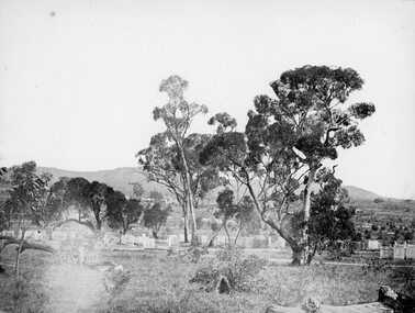
Photograph, Pleasant Creek Cemetery 1866
... of Griffith and Leslie streets, Stawell West. Stawell Pleasant Creek ...Pleasant Creek Cemetery. Part of a collection of Photographs by Mr. O.G. Armstrong as commissioned by the Shire of Stawell for the Inter-colonial and Paris Exhibition in Melbourne in 1866. The site of the Pleasant Creek Cemetery was proclaimed on October the 14th, 1861. Prior to that, a cemetery existed on ‘One Tree Hill’ where burials were made as early as 1854. A memorial is located on the site of the One Tree Hill Cemetery, corner of Griffith and Leslie streets, Stawell West. stawell -
 Bendigo Historical Society Inc.
Document - MINING REPORTS - LONDONDERRY SHAFT NO 249
' The old Londonderry Mine shaft has been capped after it opened in late July. The shaft was part of the Garden Gully Line, which held the greatest concentration of workings on the Bendigo Goldfield, has been capped after it opened in late July. The line starts under the Quarry Hill Golf Course and continues right through to Eaglehawk North'. (Source: Bendigo Advertiser, August 19, 2014.) Mine was located on Creek Street North, Bendigo. Central Deborah - Heritage Victoria Notes: Originally the Londonderry West shaft, now a mining museumHandwritten extracts by Albert Richardson (with typed copy of same) on the Londonderry Shaft, Bendigo in 1905, with reference to the brick dam being constructed.gold, mining reports, mining reports, londonderry shaft no 249, w westhead -
 Southern Sherbrooke Historical Society Inc.
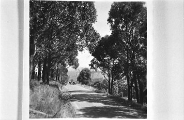
Looking west down road to Selby from Hermons Corner
A herd of cows belonging to Ryan can be seen coming up the road by the Breen farm, Menzies Creek. Trees line the road. Hills are visible in the distance. -
 Stawell Historical Society Inc
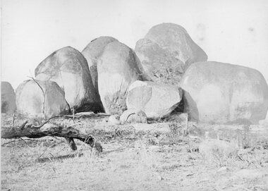
Photograph, The Sister Rocks Pleasant Creek 1866
The Sister Rocks Pleasant Creek. Part of a collection of Photographs by Mr. O.G. Armstrong as commissioned by the Shire of Stawell for the Inter-colonial and Paris Exhibition in Melbourne in 1866. sailing ship and landed at Port Ferry. They came to Stawell from the port by bullock wagon laden with goods for the goldfield and camped at the Sister Rocks and so they were named. Later the girls married. One became Mrs Hodge and lived on the Western Highway, another became Mrs D’Arcy of the Shamrock Hotel Stawell West. The third was Mrs Moore of Levithan East Stawell. Large Granite boulders with no visible Graffiti. Log on left of photo. stawell tourism -
Moorabbin Air Museum
Document (item) - Wackett trainer Boomerang CA15 Mustang Spitfire Mignet H.M. 14 Pou-du- Ciel Curtiss Hawk 75A-4 CurtissP-40E Kittyhawk Cloth Map South Celebes The Griff Falcon flapping wing Repco Steering Shaft M14A2401 1140 series Tugan LJW7 Monoplane Gannet Rotol contra rotating propeller Rolls Royce BS 360 engine oil system Avro York Handley Page nosewheel Douglas DC10 Auster aircraft Autocrat 5J1 Taylor aircraft Sulu Archipelago Philippines Victoria Australia radio centres FISCOM Tasmania air navigation chart Wagga Wagga Charleville navigation map Broken Hill Bourke New Guinea Bismarck sea Coral sea Solomon islands Gulf of Carpentaria Tennant creek Mackay Palau Suain east and west Nanu east and west Hauk East Aitape East Maprik West But west Rockhampton map Australian built beaufort poster Beaufighter 30 Squadron Poster Woomera 737 overhead instrument panel Uiver London to Melbourne 1934 1984 memorial flight Poster Air India to Australia Poster, Posters of aircraft navigational maps schematics of engines instrument panel drawings
-
 Stawell Historical Society Inc
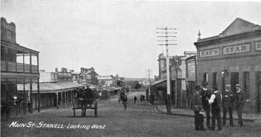
Photograph, Main Street Stawell looking West c1907. Kay's Star Hotel on Right
Main Street Looking West. Kays Star Hotel c1907 The Star Hotel had a chequered life. Like a number of other hotels it started life on Commercial Street Pleasant Creek, the first License being held by Mr. William Francis in 1858. It was shifted to Main Street Quartz Reefs in 1860 and had many tenants over a long period. For many years it stood in the centre of the roadway in Main Street and had to be moved to give more room for traffic. It is one of the reasons we have a bend in the Main Street. As a Hotel it had 54 years without a conviction against it. Although it had many licensees it was owned by one family for the last 27 years of its life as a Hotel. It was delicensed in 1916 because it was too close to the Albion which was a better building. Currently (2025) occupied by the Stawell Club and is licensed. The walkway beside it to the carpark is names Star Lane.Main Street Stawell looking West c1907. Bull & Mouth Hotel with verandahs on Left, Kay's Star Hotel on Right. Group of men talking in roadway at right. Telegraph pole prominent near centre of photo.Main St. Stawell Looking West.stawell, hotel -
Surrey Hills Historical Society Collection
Work on paper - Vertical file on Back Creek, Surrey Hills
Back Creek is one of the tributaries of Gardiners Creek. It rises as a spring on the slopes of the hill at the corner of Canterbury Road and Elgar Road in Surrey Hills, the location of a Melbourne Water tower and reservoir. It has been channelled underground from this point in pipes as far as Union Road. South Surrey Park runs along both sides of Back Creek from where the creek crosses Union Rd near Rose Avenue to where it crosses Riversdale Road just west of Through Road. A vertical file containing information about Back Creek in Surrey Hills: 1. 4 colour photos taken in 1983 (1 page). 2. ‘Pipe dreams run their course’, (Boroondara Review ?) 17.4.2013 (1 page). 3. ‘Plan rainchecked for creek impact’, Boroondara Review, 13.3.2013 (2 pages). back creek -
Stawell Historical Society Inc
Map, Underground Survey of the Principal Mines of Stawell 1879, 1879
Pleasant Creek & Newington, Prince Patrick, Prince Alfred, Pioneer and Galatea, Pleasant Creek Cross Reef No. 1&2, Magdala, Old Shaft, Extended Cross Reef, Crown Cross, Great Northern, Sloanes & Scotchmans, South Cross, 10 & 11 United Scotchmans South Cross, Scotchmans Shafts, North Scothmans, West Scotchmans, Emerald Isle & Rose of Denmark, Albion, South Scotchmans, Newington & Pleasant Creek, Pleasant Creek Cross Reef, Moonlight, Extended Cross Reef, Crown cross United, Great Northern ShaftVery large Map on cloth backing, showing cross sections of mines.Surveyed by H.C. Bates. Drawn by Arthur Edwards. October 30th 1879. Scales 120 feet to an inchmining, gold -
 Clunes Museum
Photograph, PURCELL, ROGER, 1994
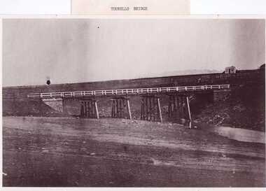
ORIGINAL PHOTOGRAPH OWNED BY MRS. LENA COOK OF CASTLEMAINE RD. CRESWICK.. THE PHOTOGRAPH WAS TAKEN LOOKING SOUTH WEST, THE SMALL COTTAGE SOUTH EAST OF HOLDING KNOWN AS 'STRAINS' ON THE CORNER OF BALLARAT AND COOK'S ROADS, MAY HAVE BEEN THE TOLL HOUSE. A WELL BESIDE THE COTTAGE IS STILL NEAR THE ROAD. BESIDE THE NEW TOURELLO BRIDGE..1 FRAMED PHOTOGRAPH OF TOURELLO BRIDGE ON BALLARAT RD. OVER COGHILLS CREEK. .2 BLACK & WHITE PHOTOGRAPH (COPY) .3 BLACK AND WHITE COPY OF ABOVE PHOTOGRAPHlocal history, photography, photographs, bridges -
 Clunes Museum
Photograph, BAWDEN PHOTOGRAPHER
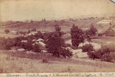
... CLUNES CREEK & CLUNES BATTERY LOOKING SOUTH WEST SEPIA PHOTOGRAPH ...SEPIA PHOTOGRAPH OF CREEK PARADE, CLUNES, AND SOUTH CLUNES BATTERYCLUNES CREEK & CLUNES BATTERY LOOKING SOUTH WESTlocal history, photography, photographs, clunes landscape -
 Clunes Museum
Photograph, BEAUCHAMP PHOTOGRAPHY, CIRCA 1884 - 1885
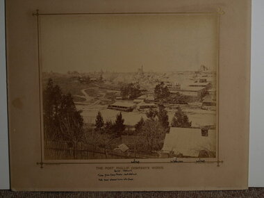
SEPIA PHOTOGRAPH OF PORT PHILLIP COMPANY'S WORKS.THE PORT PHILIP COMPANY'S WORK'S. HANDWRITTEN NOTES: PERIOD 1884 OR 5. TAKEN FROM CAMP PARADE: NOERTH WEST END NOTE SAND ALLOWED TO RUN INTO CREEK NORTH SHAFT, 2ND BATTERY HOUSE, SOUTH SHAFT. BEAUCHAMP PHOTO, 104 STURT STREET, BALLARATlocal history, mining, port phillip mine -
 Eltham District Historical Society Inc
Photograph, Antonio and Angelina Casonato and family
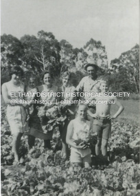
Antonio and Angelina Casonato with their four children and a baby cousin taken with lettuces growing on the river flat at Bell Street, Fabbro Farm (Fabbro Fields) in front of Eltham High School in the late 1960s. The site of the Fabbro farm (Diamond Creek side land) is now made up of Fabbro Fileds and Barrack Bushlands. This title is fairly recent after the Shire of Eltham purchased the land, including the last section in 1993/94. About this time the area on the west side of Falkiner Street was purchased by a private developer and developed as housing. The area in Bell Street opposite the Eltham High School was purchased by the State Government is recent years and is called Fabbro Fields. The Fabbro Family operated their farm in Bell Street, Eltham. 1 black and white photograph reproduction print (low quality)fabbro's farm, bell street, eltham, farming, vegetables, angelina casonato, antonio casonato, fabbro family, fabbro farm, fabbro fields -
 Sunbury Family History and Heritage Society Inc.
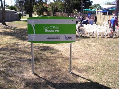
Photograph, Leo O'Brien Reserve, November 2015
The sign was erected in the reserve in November 2015. Leo O'Brien was a long time Sunbury resident and the son of Terence O'Brien, who farmed in the district. The reserve is on a section of land that Leo owned, which fronted Barkly Street to the west and Jackson Street to the east. As Sunbury developed the higher section of the property was subdivided for housing and today Terence Street is in that subdivision. The Leo O'Brien Reserve area could not be developed for housing because that land is part of the former main drain, which was a natural waterway that flowed through a part of Sunbury an entered Jacksons Creek at the end of Brook Street. Today the open drain is covered over. Terrence O'Brien served as Shire President on Shire of Bulla Council during the first two decades of the twentieth century and was also a member of the Sunbury Waterworks Trust from 1913 - 1914.A coloured photograph of sign placed at the entrance of a small open space. Tables and chairs have been set out for refreshments in the reserve.leo o'brien, leo o'brien reserve, terence o'brien -
 Ringwood and District Historical Society
Photograph, Series of 4 photos from Wantirna Rd Bridge over Dandenong Creek and Gold Course. Ringwood January 1979
4 Black and White photographs. Written on back of photographs - all prefixed "Jan '79. :Standing on top of concrete pole at end of handrail - Wantirna Rd. bridge over Dandenong Creek -" 2674-1 / SS0357a: "looking east along creek." 2674-2 / SS0357b: "looking north-east." 2674-3 / SS0357c: "looking north." (along Wantirna Road) 2674-4 / SS0357d: "looking west over gold club." -
 Lakes Entrance Historical Society
Postcard - Reeves Channel, 1910 c
Black and white postcard showing view of Reeves channel looking west toward Metung west end of Rigby and Fraser Islands mouth of Maringa creek lower right with neat mill workers cottages on flat Lakes Entrance Victoriawaterways -
 Bendigo Historical Society Inc.
Document - MCCOLL, RANKIN AND STANISTREET COLLECTION: MAP OF MINE LEASES SYMONDS STREET, MCKENZIE ST WEST AREA BENDIGO, 2nd September, 1936
Blue waxed linen paper map. On top' Mining District of Bendigo' Parish of Sandhurst, County of Bendigo' Map shows lease 10135, area 32.1.19; lease 10371, area 30.0.23; lease 10179 area 41.3.4; lease 10370, area 49.0.1. Map indicates gully leading into and State Rivers and Water supply reservoir, water race; siphon, shaft, dam, residential area and some residential lots marked. Streets include Holly Street, MacKenzie Street West, Symonds Street, Aspinall Street, Emmett Street; Bendigo Creek marked at bottom of map. Scale 4 chains to one inch. Map is not dated.bendigo, mining, mccoll rankin & stanistreet -
 Bendigo Historical Society Inc.
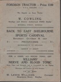
Document - BACK TO EAST SHELBOURNE SPORTS CARNIVAL, 8 October, 1927
Back To East Shelbourne Sports Carnival, Saturday, October 8, 1927. Programme. Refreshments on grounds, dance at night. 1/- Casamento's Buses. Executive Committee: President; W Harris. Vice-President; M De Araugo. Messrs. E Wright, A D Holden, W Hamilton, J Bartels, J Hinck, and H Hinck. Hon. Sec.; H M Burke. Asst. Hon. Sec.; G H Marshall. Ladies; Mesdames J Bartels, H Burke, G H Marshall, E Pocock, R Vines, and E Wright. General Committee; In addition to the above, Messrs. E Pocock, J De Araugo, F J Roberts, and W Marshall, Mesdames W Harris, A Holden, J De Araugo, F J Roberts, and Miss Pocock. Officials Judges: Messrs. T D Cairns, J Craven, and Geo. Hogben. Handicappers: Mr P Davidson (Northern District Walker's Assn.) Starter: Mr W Harris, M De Araugo, J Hinck, H Hovenden, E Pocock, W Hamilton, F J Roberts, A D Holden. Timekeeper: Mr H Hinck. Patrons: Cr, J Bartels, Nuttall & Clarke, Mrs D Punton, R S V Cocking, J Murray, and A Wells. Next 8 pages contain information on the history of East Shelbourne beginning with; This district is situated about ten miles west of south-west of Bendigo on Back Creek or Spring Creek, which received its names from the early diggers of Bendigo who, through shortage of water, were compelled to puddle at Bullock Creek or further 'back,' hence Back Creek; and because of the number of springs it contained - Spring Creek. Among the first to settle, in 1860, were Messrs. John Jenkinson, J Kilgour, T Connelly, G Nichols, R Fox, (who married Mrs James Jenkinson), Kenny, J Roberts, J Genders, J Curry, G Nevinson, Bartram, J Geary, A Nicholl, H Spencer, W Saunders, Mrs Prichard, and J Stansfield. History of East Shelbourne continues . . . Events held were Boy's (State School) Bicycle Race, Stepping the Distance (Gents), Stepping the Distance (Ladies), Bowling at the Stump, Kicking Football Through Hoop, Sheaf Toss, Bucket Ball, Sheffield, Children's Relay Race, Men's Potato Race, Tilting Rings, on Bikes, Walking Contest 1 mile, Car Race through pegs, Slow Bicycle Race 50 yards, Handicap Bicycle Race 2 miles, Tilting Rings in Cars, High Jump, Ladies' and Gent's Cigarette Race, Weight Guessing. Prizes were awarded for first and second placing of these events.In 1923, a Sports Carnival was held in the precincts of what was then a water reserve, situated south of the State School. The area was reserved for watering purposes on 1st May, 1894; and on July 15th, 1912, a small portion was excised. By 1923 its usefulness for water storage had disappeared, and being ideal for recreation purposes, it was decided, at the final meeting of the above sorts carnival, to apply for the area appointed, Mr W Harris (chairman), Messrs. G H Marshall, J Roberts, D Gill, M Connolly, R Vines, E Pocock, and H M Burke (secretary). The matter terminated in a Land Board, presided over by Mr McPherson, being held in Bendigo. The application was granted, but was not gazetted, until Messrs. W Harris and F J Roberts, with Messrs. A E Cook, MLA and Hon. H Keck, MLC interviewed the Minister for Lands. Soon afterwards, at a public meeting, the following members were elected to constitute the first Board of management, Messrs. W Harris (chairman), G H Marshall, A D Holden, F J Roberts (tres.), M D'Araugo, E Wright, and H M Burke (sec.). Since then the arena has been cleared and levelled by residents, and labor and material to the value of 150 pounds have been put into the reserve. At least 2/3rds of the program contain ads from business in Bendigo. Fordson Tractor - W Cowling, W Lewis William's Chymist, Collier footwear, William Wallace Land and Clearing Sales, Bain & Daws Groceries, Farmers & Citizens Trustees Company Bendigo Limited, Northern Seed Supply Co., Marong Bakery, Bennetts' Arcade Store, Marong Hotel, Warren's Drapery & Clothing, Jas. Friswell Butcher, Webster's Wireless, Baker & Woods Tennis Supplies, Hartleys Wireless, Cycle Hartleys, Bendigo Book & Stationery Centre Frank J Every's, T R Jones Chemist, Wool Skins & Hides F Ferguson, Furniture Carpets Linoleums Morley Johnsons, Jewellery & Silverware Prescott & Dawe, Drapers Honan & O'Toole, Stilwell's of Bendigo, Gents' & Ladies' Tailoring Hatters & Mercers Messrs. Denton Bros., Groceries Ales Wines & Spirits W Jeffrey, Ashman's Tailors Hatters Mercers, Myer's, Farmers' Grocery D Whyte & Co., Drapers & Furniture Stores The Beehive, Butcher les. Friswell, Tobacconist & Hairdresser W J Lenten, Timber Merchants & Ironmongers Hume & Iser, Stock E M Vains & Co., Ladies' & Gents' Tailors Clifford & Fulton, Printers & Stationers Bolton Bros. Pty Ltd, Bendigo Leather Shop, Everything Musical Suttons, Andrew's Auction Rooms Butter Eggs Poultry etc, Meats A C Petherick's, Albert Bush's Produce Stores & Chaff Mills, T D Cairns & Co., Jeweller C J Kirby, Casamento's Garage & Ballarat Motor Bus Service, Webster Bros. Sporting House Cycle Builders Motor Cycle & Car Agents, British Motors Bendigo, Webb's Bacon Depot. 20 pages plus coverBoltons Print, Bendigoevent, social, east shelbourne sports carnival -
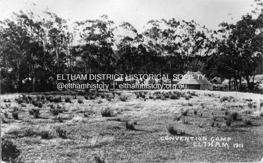 Eltham District Historical Society Inc
Photograph, Eltham - Convention Camp, 1911
Tents set up along the Diamond Creek on a property that would become "Willandra," a poultry farm and then in 1956, an aged care facility and residence known as Judge Book Village. It is located west of the railway line, north of the railway station in Eltham on Diamond Street. it is believed that the convention camp was for young people for the purpose of Christian fellowship, bible study and worship. Other activities included local hikes. A report in the Evelyn Observer on Friday, January 6, 1911, p2 noted: "ELTHAM. The holiday season brought out lots of visitors to our beauty spot. The visitors booked to Eltham on Boxing-Day numbered about 1900, and New Year's Day (Monday) some 1500. The threatening aspect of the weather on the morning of the 2nd and no doubt deterred many from venturing out. Fine weather has prevailed throughout, and the chief sufferers are those who catered for hot, thirsty crowds and did not find them so bent on ices and fluid refreshments as is usual at this time of the year. Campers have been strongly in evidence. One especially large camp of Christian enthusiasts being located near the station with dining booth, gospel tent, cooking range, etc., all complete, numbering some twenty tents. These good folk evidently intend to make the best of both worlds, but some of their negro camp meeting methods appear to have shocked the sensibilities of sober-going folk. With the exception of a slight ruction on the railway platform on Monday night, which will probably be aired in the local court, the holiday makers as a whole were very orderly." This photo forms part of a collection of photographs gathered by the Shire of Eltham for their centenary project book, "Pioneers and Painters: 100 years of the Shire of Eltham" by Alan Marshall (1971). The collection of over 500 images is held in partnership between Eltham District Historical Society and Yarra Plenty Regional Library (Eltham Library) and is now formally known as 'The Shire of Eltham Pioneers Photograph Collection.' It is significant in being the first community sourced collection representing the places and people of the Shire's first one hundred years.Digital imagesepp, shire of eltham pioneers photograph collection, eltham, convention camp, judge book village, tents, diamond creek (river), camping, christian camp, boxing day -
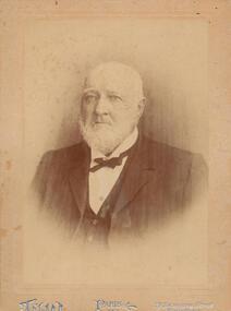 Phillip Island and District Historical Society Inc.
Photograph - Photograph, black + white, c. 1900
John Cleeland JP of Newhaven, 1826-1914, a native of County Down, Ireland, came to Victoria in 1840 with his parents and settled at Darebin Creek. After a few years spent there he went to sea in his schooner yacht of 200 tons, the Harriet, visiting the South Sea Islands and the west coast of South America. In 1859 he took the well known Albion Hotel, Bourke-street east, Melbourne, the starting place for all Cobb and Co's lines of up-country coaches, and kept it for 22 years, marrying whilst there Miss Blake, of Mornington. Shortly before leaving the hotel he purchased 7000 acres of land at Phillip Island for breeding purposes, and there bred Wollomai, who won the Melbourne Cup in 1875. In 1881 he retired to his magnificent estate, besides which he has another 1000 acres at Bass and other properties. He also once owned racing stables at Brighton, where he had Barwon (which won the Champion race) and other valuable horses. Mr Cleeland is a member of the Phillip Island Council and is a justice of the peace for the central bailiwick. Taken from Victoria and its Metropolis: past and present, 1888. Donated by Ivy Cleeland, John Cleeland's grand-daughter.Portrait of John Cleeland of Wollomai House, Phillip Island.On front: Paris, 119 Swanston Street, Melbourne On back: John Cleeland of Wollomai House.john cleeland, ivy cleeland -
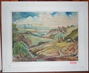 Clunes Museum
Painting, RICHARD FORD, CIRCA 1923
OIL PAINTING FEATURING BRIDGE ACROSS CRESWICK CREEK IN THE STATION FLAT AREA. NORTH WEST OF CLUNES. BRIDGE IS NOW REPLACED BY "FORD".OIL PAINTING BY CLUNES ARTIST RICHARD FORD.local history, illustration, oil, ford richard