Showing 8872 items matching " construction"
-
 Ballarat Tramway Museum
Photograph - Black & White Photograph/s, 1980
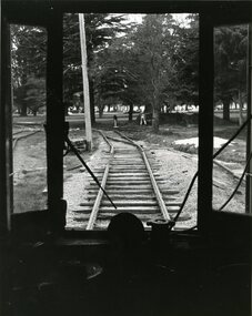
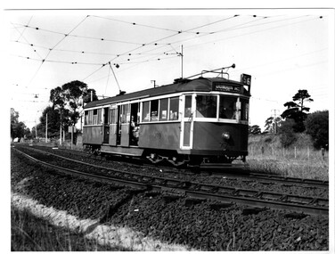
Black and White photograph of a view from the cab of W3 No. 661, looking outside the BTPS/BTM depot towards Wendouree Parade. Shows Nos 4 and 5 roads under construction. Photo used on the front cover of the 1979 - 1980 BTPS Annual Report. Photo has the caption "Waiting to Roll. W3 661 looks out onto the track it will so roll over to enter service." Photographer details not known at time of cataloguing. Assumed taken June/July 1980 for Annual report. On the rear has caption in pencil and other printing instructions including cropping remarks. See 1979 - 1980 Annual ReportsOn the back has the caption "Waiting to Roll. W3 661 looks out onto the track it will so roll over to enter service.", "Front Cover (A) in pencil, cropping marks and letters "S/S" and "Crop" in ink.tramways, trams, btm, depot, trackwork, btps, tram 661 -
 Ballarat Tramway Museum
Book, Ingersoll Rand Company, "101 and 1 ways to Save Money with Portable Compressors", 1929
Book, titled "101 and 1 ways to Save Money with Portable Compressors", published by Ingersoll-Rand Co. London, 120 page book, within yellow covers, centre stapled. Published 1929. On front cover has an colour picture of a large work scene with a the construction of a suspension bridge in the background. Details equipment that is available and the possible uses it could be put to, with numerous photos. Has a list of equipment, index and on last page a list of officers and directors. Has been stamped on the top left hand corner with the ESCo Company stamp but overwritten in ink with a BTPS catalogue number and information. Stamped dated 23 Feb. 1934.On front cover and page 1, hand written in black ink "Ballarat Tramway Preservation Society Catalogue No. 18".trams, tramways, trackwork, doors, safety, compressors, esco -
 Kew Historical Society Inc
Photograph - Cottage, probably East Kew, A. Aberline, 1920s
The Kew Historical Society's map collection includes a substantial number of real estate subdivision plans, mainly of Kew but also of surrounding suburbs in Melbourne. Most of the subdivision plans date from the 1920s and 1930s when the districts old homes and local farmland were being split up to accommodate residential growth in the postwar period. These early plans were assembled by a local firm, Jas R Mather & McMillan, which had an office in Cotham Road. Many of the plans, and sometimes photos, were annotated by the agents.Subdivision plans are historically important documents used as evidence for the growth of suburbs in Australia. They frequently provide information about when the land was sold as well as evidence relating to surveyors and real estate and financial agents. The numerous subdivision plans in the Kew Historical Society's collection represent working documents, ranging from the initial sketches made in planning a subdivision to printed plans on which auctioneers or agents listed the prices for which individual lots were sold. In a number of cases, the reverse of a subdivision plan in the collection includes a photograph of a house that was also for sale by the agent. These photographs provide significant heritage information relating house design and decoration, fencing and household gardens.The photograph may also be aesthetically significant depending on the importance of the photographic atelier.An elevated, modest weatherboard house, photographed towards the end of the construction phase. The lower section of the weatherboards are exposed and stained. The upper section is rendered with rough-cast. The tiled roof has a single gable that extends over the centrally placed front porch. On the porch, the door and single sidelight are filled with coloured leadlight whereas the casement windows in the front rooms contain plain glass. The leadlight and the wrought iron of the verandah are the only decorative elements of the utilitarian design. The location of the house, which was advertised for sale, has not to date been identified. The real estate photograph is mounted on the reverse of a subdivision plan for the Harvest Home Estate, Kew East.Photographer's stamp, lower right on mount: "A. Aberline, Glenferrie"houses - kew, bungalows - kew, real estate photographs -
 Falls Creek Historical Society
Journal - Ski-Horizon Vol. 1 No 6
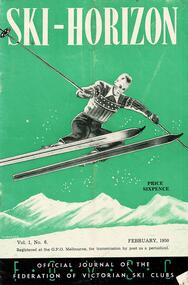
Ski-Horizon is the official journal of the Federation of Victorian Ski Clubs which began publication in 1949. The were 26 original member clubs which included Albury Ski Club, Bogong Ski Club, Myrtleford Ski Club, Tallangatta and District Ski Club and Wangaratta Ski Club. Two pioneers of Falls Creek, Tom Mitchell, M.L.A., and Martin Romuld were Vice-Presidents of the Federation.This Journal is significant because it documents the early development of skiing in Victoria.The journal features stories and events chronicling developments in Victoria and internationally. Items related to the Falls Creek Area in this publication include:- Page 14: In evidence before the State Development Committee at Mt. Beauty, Tom Mitchell outlined the need for further construction of roads in the area and stated a case for the development of an alpine village to be established at Falls Creek. He also suggested that the question of ski tows be left to the ski clubs, but that the Government consider the installation of a chair-hoist at Spion Kopje. It also seemed likely that the 1950 Victorian State titles and the 1951 International Race with New Zealand will be held in the Falls Creek-Spion Kopje area. ski history victoria, federation of victorian ski clubs, nedsa events, victorian skiing 1949 -
 Melbourne Tram Museum
Document - Memorandum, The Met, “W class tram Overhaul”, Oct. 1988
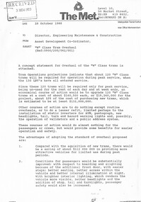
Photocopy of a Memorandum 4 A4 sheets - stapled in the top right hand corner, titled “W class tram Overhaul”, appears to be missing one sheet, dated 28/10/1988 looking at the concept program for overhauling W class trams to provide a front entry (the proposal for a W8 class) and many other changes. Looking at deferring the purchase of new trams. Would provide trams for the peak periods. Details the costs and proposed changes. See Reg item 1596 for associated concept sketches. Memo written by Howard Smith (Asset Development Co-coordinator) to Director Engineering Maintenance and Construction of The Met letterhead.trams, tramways, preston workshops, w class, overhauls, w8 class, the met, drivers -
 Melbourne Tram Museum
Letter, Yarra Trams, "Tram track renewal and tram stop upgrade works", 1/06/2012 12:00:00 AM
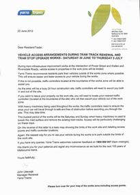
Set of two A4 sheets, printed both sides, titled "Tram track renewal and tram stop upgrade works", for the reconstruction of the intersection of Power Street, Wallen Road and Riversdale Rd.", Saturday 30/6 to 5/7/2012. Work included the construction of the platform stop, relocation of the cross over from Riversdale Rd to Wallen Road and the reconstruction of the track into the Hawthorn depot. Gives timetable for works, access arrangements for the apartments and the tram depot. Has a map showing work locations. Dated 18/6 and 22/6/2012, signed by John Uiterwijk, Manager Renewals Yarra Trams.trams, tramways, yarra trams, trackwork, wallen rd, riversdale road, riversdale junction, power st, hawthorn depot -
 Melbourne Tram Museum
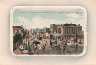
Postcard, "Collins St looking East from Wesleyan Chapel, Melbourne in the fifties", 1850's original image
Postcard - coloured embossed surround a reproduced engraving of "Collins St looking East from Wesleyan Chapel, Melbourne in the fifties", prior to the construction of The Treasury building. Has a number of horse and oxen drawn vehicles. Possibly to the east of Queen St. Dated 1850's Has the title "Collins St looking East from Wesleyan Chapel, Melbourne in the fifties" along the top of the postcard. https://en.wikipedia.org/wiki/Wesley_Church,_Melbourne accessed 7/4/2019 gives some details but not the actual location in Collins St. Was replaced in 1858 by a church in Lonsdale St. Divided back type with space for correspondence and address and stamp.trams, tramways, collins st, postcards, horse drawn vehicle -
 Melbourne Tram Museum
Slide - Set of 3, Keith Caldwell, 25/04/1964 12:00:00 AM
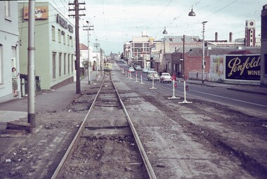
Set of three Agfa colour slides, blue / white plastic mounts, photos by Keith Caldwell March 1963 of the reconstruction of tram track in Church St Richmond. .1 - Looking south from near William and Church Streets. In the background is Bryant & May buildings and Flexpax (McFarlane Bros) and Penfolds wines on a hoarding. .2 - ditto with W2 397 Southbound, route 79 to St Kilda Beach (has adverts for Milk and Coffey Ford), passing W5 730 to North Richmond. Has adverts for Stillwells of Kew and Drambuie. .3 - ditto showing the nature of the construction of the old track being replaced. 25/4/1964In ink "Relay Chapel St 25.4.64"trams, tramways, church st, richmond, w2 class, w5 class, route 79, trackwork, temporary track, tram 397, tram 730 -
 Melbourne Tram Museum
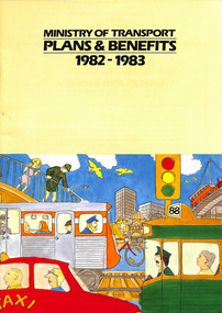
Pamphlet, Minister of Transport, "Ministry of Transport - Plans and Benefits 1982 - 1983", 1982
Sixteen page, full colour, glossy paper, centre stapled pamphlet titled "Ministry of Transport - Plans and Benefits 1982 - 1983", providing details of the plans for 1982-1983 of the Victorian Ministry of Transport, including notes on transport notes, funding sources, jobs, transport benefit and particular notes for users of the various modes of transport. Has a Foreword by Steve Crabb, Minister of Transport. Also has notes on Road Safety, deaths on the road and contact information. Note the contact details are for the former organisational names. Information provided for: Metropolitan Transport Authority - The Met Road Construction Authority State Transport Authority Road Traffic Authority.trams, tramways, minister for transport, metropolitan transit authority, state transport authority -
 Melbourne Tram Museum
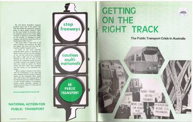
Book, Friends of the Earth, "Getting on the Right Track - The public transport crisis in Australia", mid to late 1970's
Book - 104 pages printed on newsprint, stapled with two colour light card cover, titled "Getting on the Right Track - The public transport crisis in Australia". Produced by the National Action for Public Transport, largely transport union based (see page 104 for contacts), looking at the lack of investment into public transport and the construction of freeways, roads and the growth of motor cars. Has a table of contents and many sketches, cartoons and tables. See inside front cover for sources, names and who produced the document, Friends of the Earth. Appears to have been produced mid to late 1970's. Two copies held.Has a "$1.50" Angus and Robertson price sticker on the front cover, top right hand corner.trams, tramways, public transport, unions, motor vehicles, road transport -
 Melbourne Tram Museum
Photograph - Black & White Photograph/s, early 1950's?
Black and white photograph of W5 No. 779 inbound to the City and Domain Road on route 56, on the open ballasted track just before passing under the railway line at the Zoo gardens area. Shows the open doors with the bars down. Photo of the tram slightly out of focus. Taken early 1950's by an unknown photographer. In the overhead shows a sign black cross in a circular disc and behind the tram a incandescent light suspended in the middle of the overhead. The photo shows the construction of the track at this location, dog spiked sleepers, the rail supports for the inner check rail. In the background behind the tram is the lever for the points of the crossover.On the rear in red ink "Melbourne tram shows use of Off-street tracks in an outer suburb"trams, tramways, zoo tram, reserved track, track construction, w5 class -
 Ballarat Tramway Museum
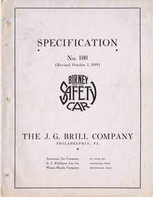
Document - Specification, J.C. Brill Co. of Philadelphia, "Specification No. 100 - Birney Safety Car", 1919
Specification document comprising printed cover, eight typewritten pages (black carbon copy) and two photo pages of a J.G. Brill Co. of Philadelphia PA, Birney Safety Car. Specification No. 100, revised 1/10/1919. On the printed cover, which has three holes for a clip on the left hand side, printed with the Birney Safety Car trade mark, the names of the J. G. Brill associated companies (American Car Company of St. Louis, G. C. Kuhlman Car Co. of Cleveland Ohio, and Wason Manufacturing Company of Springfield, Massachusetts). On the inside of the front cover and on the outer back cover is the Brill logo. On the inside of the back cover is a floor / seating plan of the Birney Safety Car, giving overall dimensions, location of equipment etc. Item secured with one brass clip in the top left hand corner. The eight typed pages details the specification of the construction of the tramcar, equipment details etc for a single truck, double end Birney Safety (tram) car. Gives dimensions of the tramcar, materials, construction methods, finishes, equipment, glass, etc. Also details additional items that could be ordered with the tramcar. First photo shows the Birney car without a trolley pole, lettered for the KC Rys. Co. The second photo shows an interior view of the tramcar. Scanned for COTMA Website - pdf version.trams, tramways, birney, j. c. brill co., tramcar specifications, tramcar construction -
 Kew Historical Society Inc
Plan, Melbourne & Metropolitan Board of Works : Borough of Kew : Detail Plan No.1576, 1904
The Melbourne and Metropolitan Board of Works (MMBW) plans were produced from the 1890s to the 1950s. They were crucial to the design and development of Melbourne's sewerage and drainage system. The plans, at a scale of 40 feet to 1 inch (1:480), provide a detailed historical record of Melbourne streetscapes and environmental features. Each plan covers one or two street blocks (roughly six streets), showing details of buildings, including garden layouts and ownership boundaries, and features such as laneways, drains, bridges, parks, municipal boundaries and other prominent landmarks as they existed at the time each plan was produced. (Source: State Library of Victoria)This plan forms part of a large group of MMBW plans and maps that was donated to the Society by the Mr Poulter, City Engineer of the City of Kew in 1989. Within this collection, thirty-five hand-coloured plans, backed with linen, are of statewide significance as they include annotations that provide details of construction materials used in buildings in the first decade of the 20th century as well as additional information about land ownership and usage. The copies in the Public Record Office Victoria and the State Library of Victoria are monochrome versions which do not denote building materials so that the maps in this collection are invaluable and unique tools for researchers and heritage consultants. A number of the plans are not held in the collection of the State Library of Victoria so they have the additional attribute of rarity.Original survey plan, issued by the MMBW to a contractor with responsibility for constructing sewers in the area identified on the plan within the Borough of Kew. The plan was at some stage hand-coloured, possibly by the contractor, but more likely by officers working in the Engineering Department of the Borough and later Town, then City of Kew. The hand-coloured sections of buildings on the plan were used to denote masonry or brick constructions (pink), weatherboard constructions (yellow), and public buildings (grey). Development in the 20th century has irreparably altered that part of Kew represented in this plan. In the block bounded by Cotham Road, Charles Street, Wellington Street and Gellibrand; just one house standing in 1903 remains. This block included two of the most historic houses in Kew: ‘Ordsall’ (later ‘Southesk’) and ‘Madford’ (previously ‘Elm Lodge’). Ordsall was the home of the second chairman of Kew, John Halfey. It contained some of the most significant interior murals in Kew, created for Halfey by artists working for Cullen & Co. It was demolished in 1960 to make way for the Kew Civic Centre. Elm Lodge had been built for William Siddeley in ca. 1864. Arthur Septimus King purchased it in 1874. The lower paddocks of Madford were sold in 1905 by his wife to the Borough of Kew and, after landscaping by George and Thomas Pockett, opened as the Alexandra Gardens in 1908. Elm Lodge/Madford was in 1922 to become St. Anthony’s Home for Little Children before its subsequent demolition in the 1980s.melbourne and metropolitan board of works, detail plans, maps - borough of kew, mmbw 1576, cartography -
 Kew Historical Society Inc
Plan, Melbourne & Metropolitan Board of Works : Borough of Kew : Detail Plan No.1581, 1904
The Melbourne and Metropolitan Board of Works (MMBW) plans were produced from the 1890s to the 1950s. They were crucial to the design and development of Melbourne's sewerage and drainage system. The plans, at a scale of 40 feet to 1 inch (1:480), provide a detailed historical record of Melbourne streetscapes and environmental features. Each plan covers one or two street blocks (roughly six streets), showing details of buildings, including garden layouts and ownership boundaries, and features such as laneways, drains, bridges, parks, municipal boundaries and other prominent landmarks as they existed at the time each plan was produced. (Source: State Library of Victoria)This plan forms part of a large group of MMBW plans and maps that was donated to the Society by the Mr Poulter, City Engineer of the City of Kew in 1989. Within this collection, thirty-five hand-coloured plans, backed with linen, are of statewide significance as they include annotations that provide details of construction materials used in buildings in the first decade of the 20th century as well as additional information about land ownership and usage. The copies in the Public Record Office Victoria and the State Library of Victoria are monochrome versions which do not denote building materials so that the maps in this collection are invaluable and unique tools for researchers and heritage consultants. A number of the plans are not held in the collection of the State Library of Victoria so they have the additional attribute of rarity.Original survey plan, issued by the MMBW to a contractor with responsibility for constructing sewers in the area identified on the plan within the Borough of Kew. The plan was at some stage hand-coloured, possibly by the contractor, but more likely by officers working in the Engineering Department of the Borough and later Town, then City of Kew. The hand-coloured sections of buildings on the plan were used to denote masonry or brick constructions (pink), weatherboard constructions (yellow), and public buildings (grey). The streets and built structures in this plan were surveyed in 1903 and released to contractors in 1904. In addition to the designation of building types by colour, the plan includes detailed descriptions of land use and ownership. While many buildings remain from this period, a number of the buildings represented have been demolished including the original Kew Town Hall, and the Congregational and Roman Catholic churches in Walpole Street. While the mansion ‘Illapa’ in Princess Street is still extant – now part of ‘Rylands’ – the neighbouring mansion ‘Elsmere’ was demolished some decades ago. Rivalling Illapa and Elsmere in size were two mansions in Walpole Street, one named on the plan as ‘Gnarlbine’. Over time, Kew Junction and the south side of High Street have been reconfigured and widened, so that the commercial buildings on the corner of Princess and High Street no longer exist. A surprising feature of this part of central Kew to the northwest of Kew Junction is the amount of vacant land. In a number of cases, this land is noted by the contractor as used for vegetable gardens.melbourne and metropolitan board of works, detail plans, maps - borough of kew, mmbw 1581, cartography -
 Kew Historical Society Inc
Plan, Melbourne and Metropolitan Board of Works, Melbourne & Metropolitan Board of Works : Borough of Kew : Detail Plan No.1294 & 1295, 1904
The Melbourne and Metropolitan Board of Works (MMBW) plans were produced from the 1890s to the 1950s. They were crucial to the design and development of Melbourne's sewerage and drainage system. The plans, at a scale of 40 feet to 1 inch (1:480), provide a detailed historical record of Melbourne streetscapes and environmental features. Each plan covers one or two street blocks (roughly six streets), showing details of buildings, including garden layouts and ownership boundaries, and features such as laneways, drains, bridges, parks, municipal boundaries and other prominent landmarks as they existed at the time each plan was produced. (Source: State Library of Victoria). This plan forms part of a large group of MMBW plans and maps that was donated to the Society by the Mr Poulter, City Engineer of the City of Kew in 1989. Within this collection, thirty-five hand-coloured plans, backed with linen, are of statewide significance as they include annotations that provide details of construction materials used in buildings in the first decade of the 20th century as well as additional information about land ownership and usage. The copies in the Public Record Office Victoria and the State Library of Victoria are monochrome versions which do not denote building materials so that the maps in this collection are invaluable and unique tools for researchers and heritage consultants. A number of the plans are not held in the collection of the State Library of Victoria so they have the additional attribute of rarity.Original survey plan, issued by the MMBW to a contractor with responsibility for constructing sewers in the area identified on the plan within the Borough of Kew. The plan was at some stage hand-coloured, possibly by the contractor, but more likely by officers working in the Engineering Department of the Borough and later Town, then City of Kew. The hand-coloured sections of buildings on the plan were used to denote masonry or brick constructions (pink), weatherboard constructions (yellow), and public buildings (grey).The streets and built structures in MMBW Detail Plan 1294 & 1295 were surveyed in 1903 and released to contractors in 1904. This plan is one of two in the collection where the lithographers amalgamated two separate plans. Both plans include sections of Studley Park. Dominating the south and west corners of Kew Junction are the Clifton and Kew Hotels. The Kew Hotel, owned by Patrick O’Shaughnessy was one of the oldest in Kew. MMBW plans were amended over time to take account of new subdivisions such as that which created Merrion Place. Of the four mansions shown in Studley Park Road, three remain – ‘Field Place’, the home of Frances Henty, ‘Leaghur’ and ‘Darley’. ‘Byram’ (later ‘Goathland’, then ‘Tara Hall’) was an architectural marvel. Designed in 1888 by E.G. Kilburn for the paper magnate George Ramsden, it was demolished in 1960. While an earlier sale of the southern section of Byram had created Tara Avenue in 1927, the demolition of the house in 1960 enabled the extension of Tara Avenue northward.melbourne and metropolitan board of works, detail plans, mmbw 1294, mmbw 1295, cartography -
 Kew Historical Society Inc
Plan, Melbourne & Metropolitan Board of Works : Borough of Kew : Detail Plan No.1297, 1904
The Melbourne and Metropolitan Board of Works (MMBW) plans were produced from the 1890s to the 1950s. They were crucial to the design and development of Melbourne's sewerage and drainage system. The plans, at a scale of 40 feet to 1 inch (1:480), provide a detailed historical record of Melbourne streetscapes and environmental features. Each plan covers one or two street blocks (roughly six streets), showing details of buildings, including garden layouts and ownership boundaries, and features such as laneways, drains, bridges, parks, municipal boundaries and other prominent landmarks as they existed at the time each plan was produced. (Source: State Library of Victoria)This plan forms part of a large group of MMBW plans and maps that was donated to the Society by the Mr Poulter, City Engineer of the City of Kew in 1989. Within this collection, thirty-five hand-coloured plans, backed with linen, are of statewide significance as they include annotations that provide details of construction materials used in buildings in the first decade of the 20th century as well as additional information about land ownership and usage. The copies in the Public Record Office Victoria and the State Library of Victoria are monochrome versions which do not denote building materials so that the maps in this collection are invaluable and unique tools for researchers and heritage consultants. A number of the plans are not held in the collection of the State Library of Victoria so they have the additional attribute of rarity.Original survey plan, issued by the MMBW to a sewage contractor with responsibility for constructing sewers in the area identified on the plan within the Borough of Kew. The plan was at some stage hand-coloured, possibly by the contractor, but more likely by officers working in the Engineering Department of the Borough and later Town, then City of Kew. The hand-coloured sections of buildings on the plan were used to denote masonry or brick constructions (pink), weatherboard constructions (yellow), and public buildings (grey). This plan of Kew encompasses the area bounded by Barkers Road, High Street and Stevenson Street. Because of the angle created by High Street, a number of houses on the northern side of High Street are shown. The area is dominated by one of the great original landholdings in Kew, described here as the ‘Findon Paddock’. ‘Findon’, the house from which the name of the paddock was taken fronts Stevenson Street and was clearly a rambling structure. The best-known occupant of Findon was Henry ‘Money Miller’ who bought the house in 1871. Miller was a member of Victoria’s first parliament and assisted in the framing of its constitution. Findon was to be subdivided as early as 1912, when the Findon Subdivision was advertised to be sold by auction. In the plan of the subdivision, the original house is not shown, so, presumably it had previously been demolished. Fincham & Son moved the organ, built by Henry Willis, which was installed in the house, first to ‘Whernside’ in Toorak, and later to the Box Hill Methodist Church.melbourne and metropolitan board of works, detail plans, mmbw 1297, cartography, kew (vic.) — municipal collection -
 Kew Historical Society Inc
Plan, Melbourne & Metropolitan Board of Works : Borough of Kew : Detail Plan No.1568, 1905
The Melbourne and Metropolitan Board of Works (MMBW) plans were produced from the 1890s to the 1950s. They were crucial to the design and development of Melbourne's sewerage and drainage system. The plans, at a scale of 40 feet to 1 inch (1:480), provide a detailed historical record of Melbourne streetscapes and environmental features. Each plan covers one or two street blocks (roughly six streets), showing details of buildings, including garden layouts and ownership boundaries, and features such as laneways, drains, bridges, parks, municipal boundaries and other prominent landmarks as they existed at the time each plan was produced. (Source: State Library of Victoria)This plan forms part of a large group of MMBW plans and maps that was donated to the Society by the Mr Poulter, City Engineer of the City of Kew in 1989. Within this collection, thirty-five hand-coloured plans, backed with linen, are of statewide significance as they include annotations that provide details of construction materials used in buildings in the first decade of the 20th century as well as additional information about land ownership and usage. The copies in the Public Record Office Victoria and the State Library of Victoria are monochrome versions which do not denote building materials so that the maps in this collection are invaluable and unique tools for researchers and heritage consultants. A number of the plans are not held in the collection of the State Library of Victoria so they have the additional attribute of rarity.Original survey plan, issued by the MMBW to a contractor with responsibility for constructing sewers in the area identified on the plan within the Borough of Kew. The plan was at some stage hand-coloured, possibly by the contractor, but more likely by officers working in the Engineering Department of the Borough and later Town, then City of Kew. The hand-coloured sections of buildings on the plan were used to denote masonry or brick constructions (pink), weatherboard constructions (yellow), and public buildings (grey). Plan No.1568 covers the area bounded by Cotham Road, John Street, Sackville Street, and Edward Street. Alfred Street and Rowland Street are in shown in the middle of the plan. The two most notable buildings shown are ‘St Helliers’, the home of the Dumaresq family, and St Hilary’s Church and school. While the colours used to indicate St Hilary’s are grey as in other civic/public buildings, the first St Hilary’s Anglican Church was at this stage constructed in weatherboard. At the left of the plan, facing Sackville Street is a house named ‘Glencara’. The 1988 ‘Kew Conservation Study’ recorded that “The first documentary evidence of this house comes from Rate Books which record that in 1893 a Mrs Treadway was the owner of this building with an N.A.V. of £81? At that date the occupier of the house was Charles B. Kelly, a clerk, while by 1910 Kelly had become the owner of the property described in that year ‘as a six-roomed stone, brick and wood house with stables and outbuildings’”. Contrary to this description, the 1905 plan indicates that the house was entirely constructed of masonry.melbourne and metropolitan board of works, detail plans, mmbw 1568 -
 Kew Historical Society Inc
Plan, Melbourne & Metropolitan Board of Works : Borough of Kew : Detail Plan No.1571, 1904
The Melbourne and Metropolitan Board of Works (MMBW) plans were produced from the 1890s to the 1950s. They were crucial to the design and development of Melbourne's sewerage and drainage system. The plans, at a scale of 40 feet to 1 inch (1:480), provide a detailed historical record of Melbourne streetscapes and environmental features. Each plan covers one or two street blocks (roughly six streets), showing details of buildings, including garden layouts and ownership boundaries, and features such as laneways, drains, bridges, parks, municipal boundaries and other prominent landmarks as they existed at the time each plan was produced. (Source: State Library of Victoria)This plan forms part of a large group of MMBW plans and maps that was donated to the Society by the Mr Poulter, City Engineer of the City of Kew in 1989. Within this collection, thirty-five hand-coloured plans, backed with linen, are of statewide significance as they include annotations that provide details of construction materials used in buildings in the first decade of the 20th century as well as additional information about land ownership and usage. The copies in the Public Record Office Victoria and the State Library of Victoria are monochrome versions which do not denote building materials so that the maps in this collection are invaluable and unique tools for researchers and heritage consultants. A number of the plans are not held in the collection of the State Library of Victoria so they have the additional attribute of rarity.Digital copy of the original survey plan, issued by the MMBW to a contractor with responsibility for constructing sewers in the area identified on the plan within the Borough of Kew. The plan was at some stage hand-coloured, possibly by the contractor, but more likely by officers working in the Engineering Department of the Borough and later Town, then City of Kew. The hand-coloured sections of buildings on the plan were used to denote masonry or brick constructions (pink), weatherboard constructions (yellow), and public buildings (grey). This plan is part of a large and historically significant group of MMBW plans and maps that was donated to the Society by the Mr Poulter, City Engineer of the City of Kew in 1989. When the contracts were let for surveyors to identify and record the extant houses and landscapes within an area for the Board of Works, the contracts were let at separate times, hence the anomaly where two copies of Plan No.1571 exist in our collection. The first of these plans identifies the building materials used in houses bordering Fitzwilliam Street, Edgevale Road, May Street, Malin Street, Davis Street and Wellington Street. The cut off point for the survey was the south side of Wellington Street. By 1903 when the survey was undertaken many of the sites were already built on, particularly those facing Edgevale Road. The plan identifies the preponderance of weatherboard houses in the area. The other version of the plan identifies the buildings between Wellington Street and Cotham Road.melbourne and metropolitan board of works, detail plans, mmbw 1571, cartography -
 Kew Historical Society Inc
Plan, Melbourne & Metropolitan Board of Works : Borough of Kew : Detail Plan No.1573, 1905
The Melbourne and Metropolitan Board of Works (MMBW) plans were produced from the 1890s to the 1950s. They were crucial to the design and development of Melbourne's sewerage and drainage system. The plans, at a scale of 40 feet to 1 inch (1:480), provide a detailed historical record of Melbourne streetscapes and environmental features. Each plan covers one or two street blocks (roughly six streets), showing details of buildings, including garden layouts and ownership boundaries, and features such as laneways, drains, bridges, parks, municipal boundaries and other prominent landmarks as they existed at the time each plan was produced. (Source: State Library of Victoria)This plan forms part of a large group of MMBW plans and maps that was donated to the Society by the Mr Poulter, City Engineer of the City of Kew in 1989. Within this collection, thirty-five hand-coloured plans, backed with linen, are of statewide significance as they include annotations that provide details of construction materials used in buildings in the first decade of the 20th century as well as additional information about land ownership and usage. The copies in the Public Record Office Victoria and the State Library of Victoria are monochrome versions which do not denote building materials so that the maps in this collection are invaluable and unique tools for researchers and heritage consultants. A number of the plans are not held in the collection of the State Library of Victoria so they have the additional attribute of rarity.Original survey plan, issued by the MMBW to a contractor with responsibility for constructing sewers in the area identified on the plan within the Borough of Kew. The plan was at some stage hand-coloured, possibly by the contractor, but more likely by officers working in the Engineering Department of the Borough and later Town, then City of Kew. The hand-coloured sections of buildings on the plan were used to denote masonry or brick constructions (pink), weatherboard constructions (yellow), and public buildings (grey). This plan has detailed annotations written in red or blue ink, showing prices, which may be the annual valuations of the properties, and some owners’ names, a most unusual feature on contractor's maps. Some areas, such as the buildings of Methodist Ladies’ College (MLC), include the school’s tennis court and swimming pool, but are not coloured to show building materials – did the draftsman just run out of time, or ink, or enthusiasm, before his plan had to be submitted? MLC had been founded in 1882 as a ‘modern school of the first order’ with buildings that formed ‘a collegiate institution for girls unsurpassed in the colonies’. The goal of its founders was to provide a high-class Christian education for girls, comparable with that provided elsewhere for boys. Some shops are shown along Edgevale Road, though they are not designated as commercial premises. Larger houses are depicted, including ‘Fairlawn’ in Barkers Road, and ‘Clevedon’ and ‘Rosehill’ (now demolished) in Fitzwilliam Street.melbourne and metropolitan board of works, detail plans, mmbw 1573, maps - borough of kew, cartography -
 Melbourne Tram Museum
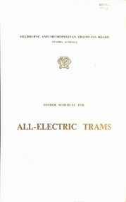
Document - Tender Document, Melbourne & Metropolitan Tramways Board (MMTB), "Tender Schedule for All-Electric Trams - Contract 2500", Jul. 1972
Comb bound (white plastic) specification or tender document, approx. 70 pages, with glossy card covers, titled "Tender Schedule for All-Electric Trams" and "Contract 2500", published by the Melbourne and Metropolitan Tramways Board, closing Monday 2 October 1972. Details the conditions of tender, conditions of contract, notes, specification, gives background information about Melbourne, dimensions, performance, drivers and conductors, trucks, wheels, brakes, electrical equipment, control panels and drawings. The drawings give a map of the system, typical city route, Glenferrie Road route (grade diagram), concrete track construction, min. radius curves, loading gauge, all-electric tram and mounting details for the trolley base, schedule of prices, tender form, form of contract, schedule of information to be provided by the tenderer. On the inside of the cover is a memo from D. Snell, Deputy Chairman to the Testing Engineer, dated 11/7/1972 about the tender being issued, but requesting least publicity and all enquiries to Mr. Snell. Part of the work to tender for the construction of Z class trams. Document scanned to pdf file word searchable. See Item 4388 for the Z3 document and 1583 for an August 1966 version and Reg item 4667 for a draft June 1965 version. 2nd copy added 7/8/2020 from Keith Kings papers.In in pencil in the top right hand corner of cover "1975" crossed out and "1972" written in. On first sheet in pencil, "Howard Smith" and "Laboratory 10 Feb 1975" stamped on.trams, tramways, specification, tenders, z class, mmtb, melbourne -
 Melbourne Tram Museum
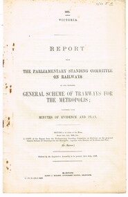
Document - Report, The Parliamentary Standing Committee on Railways, "General Scheme of Tramways for the Metropolis" & "East Northcote and Ivanhoe Railless Electric Tramways", 1922 and 1923
Set of two reports from The Parliamentary Standing Committee on Railways. .1 - 8 pages - stapled report titled "General Scheme of Tramways for the Metropolis", dated 24/7/1923, examining the MMTB's General Scheme for Tramways (See Reg Item 2088, 2089 and 2098), includes financial position of the Board, tramway or railways, the scheme itself, committee recommendations and view of the railway's commissioners. .2 - 8 pages - stapled report titled "East Northcote and Ivanhoe Railless Electric Tramways" - dated 26/10/1922 - looking at proposal for a Railless tramway (trolley bus), district to be served for residential districts, proposals, annual costs, expenses, alternative routes, betterment tax or municipal guarantee, effect on railway revenue, view of the committee and recommendations. Note: These document are available as a pdf on the Parliament of Victoria website..2 - has "Mr. Lormer" in ink on top left hand corner.trams, tramways, mmtb, general scheme, tramways, development, parliament, railways, finances, construction, trolley buses, railless, northcote, ivanhoe -
 Orbost & District Historical Society
black and white photograph, 1911
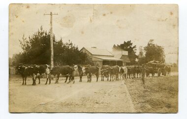
This photo shows Jas Lynn of Orbost driving a team of bullocks pulling a large cart of maize. They are taking it to the fisherman's Wharf in Lakes Entrance. Maize has been grown on the Orbost flats since the late 19th century. Transport was always an obstacle to economic sucess. For a few years prior to the First World War and the construction of the railway line from Bairnsdale to Orbost, a lot of maize was carted by horse and bullock teams to Lakes Entrance for transhipment to the Melbourne market. At that .time yields of 90 to 100 bushels of maize were quite a common occurrence. James Lynn, a member of the East Gippsland Maize Board, farmed at Jarrahmond.This photograph is associated with the large maize growing industry in the Orbost region. A black / white photograph of a bullock team pulling a large, loaded cart. It is being driven by a man standing on the side of the road, holding a whip. In the background are houses and a telegraph pole.on back - " Carting maize to Lakes Entrance in 1911."transport-bullocks maize-orbost lynn-james -
 Orbost & District Historical Society
black and white photograph, first half 20th century
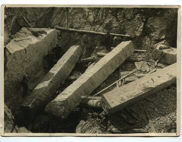
This photograph shows men cutting marble slabs at Buchan on James Cameron's property. The marble was used in the Shrine of REmembrance in Melbourne. The slabs in the photograph were about 8.5 metres long. The Shrine of Remembrance was created to meet the needs of a grieving community after the extensive loss of lives in the First World War (1914 –18). Sixteen dark Ionic columns were made of .Buchan marble In the early 1900s black marble was being mined in the Bruthen district. Some was used for the Shrine of Remembrance in Melbourne and also Australia House in London. 900 tonnes were shipped to London to be included in the construction of Australia House. Marble quarrying has been a significant part of the history of Buchan in East Gippsland. Its inclusion in the Shrine of Remembrance War Memorial is noteworthy.A black / white photograph of four men working in a quarry with three large slabs of marble on the ground.on back - " Cutting marble slabs......"buchan-marble shrine-of-remembrance cameron-james geology -
 Orbost & District Historical Society
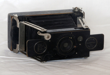
camera, 1907-1915
The ensignette was a vest pocket camera. The Ensignette was one of the very characteristic camera types of Houghtons Ltd., London. This strut folding roll film camera of Houghton's "Ensign – British made" brand was an ingenious construction, a real vest pocket item when folded. One of the round framed impressions on its front plate says that it was based on patent 28464 of the year 1907. The Swedish engineer Magnus Neill had designed this first British all-metal camera of which ten of thousands were made. The camera was launched before Christmas 1909. It was ordered by distributors all over the world, for example by G. Gennert. (Ref: camerapedia) The Ensignette was very popular because it was one of the first practical, compact cameras at an affordable price to the average man. A miniature bellows, roll film, camera - Ensignette No. 2. It is black metal with folding bellows. On the front is an aperture control knob. There is a window at the back for the film number.Flag with Union Jack Ensignphotography ensignette camera -
 Kiewa Valley Historical Society
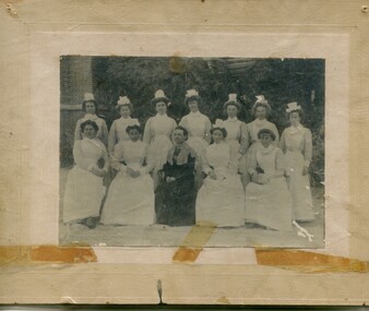
Photographs – Group of 3 old sepia photographs, 2 of women in period costume and 1 of group of nurses from Sunbury sanatorium
Europeans arrived in the Kiewa Valley in the 1830s and 40s. Following the drought of 1838-44 seeking out the rich pastures in the fertile Kiewa Valley. . The next major increase in population was as a result of the Kiewa Hydro Scheme. The beginning of construction of the Kiewa Hydro-electric scheme in the late 1940s introduced changes and led to the enlargement and improvement of local roads and the townships of Mount Beauty and Bogong Village were constructed by the SECV from the 1930’s to the 1950’s to house workers on the Kiewa Hydro Electric Scheme. At its peak the Kiewa Scheme employed around 4000 people from all walks of life and as many cultures.The influx of European migrants to work on the Hydro Scheme along with their rich cultural backgrounds, all played a major part in establishing the history of the area and in shaping the future character of the Mount Beauty, the Kiewa Valley and Falls Creek areas. Photographs may depict descendants, family or friends of early settlers or workers in the Kiewa Valley region.1. Sepia photograph, mounted on heavy buff card with yellowing marks from sticking tape across the bottom of the photograph. Photograph is of a group of nurses taken at the Sunbury Sanitorium 2. Sepia photograph mounted on heavy buff card with yellowing marks from sticking tape at top and bottom of photo. Mark from drawing pin in centre top of photo. Photograph is of a middle aged woman posing dressed in period costume 3. Sepia photograph mounted on heavy buff card with yellowing marks from sticking tape at top and bottom of photo. Mark from drawing pin in centre top of photo. Photograph is of an older woman posing dressed in period costume sepia photos; nurses; kiewa valley; sunbury sanitorium; period costume -
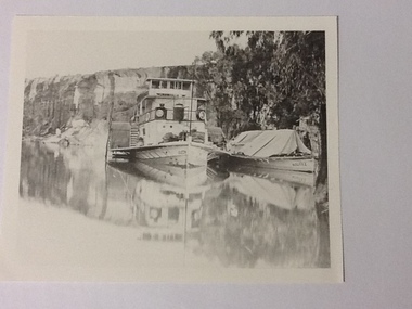 Port of Echuca
Black and white photograph, Approx.1980
Details of P. S. Queen: construction: composite 16 h.p. Registered tonnage: gross 128, net 92. Dimensions:L.103.3 ft B.18.5ft. D 5.7ft. Port and date of registry:Adelaide, 1880, no.43, 154. Built at Goolwa, S.A., 1865!. Owner: Chas Oliver. Lengthened in 1872. Details of barge Bourke. Construction:wood. Tonnage: 124. Dimensions:L 108.5 ft X B 20.5 ft X D 8.0 ft. Port and date of registry:Adelaide, 1898, no. 74, 771. built at: Miland, S. A. 1876. Owner: A. L. Land seer. Information from "The register of Australian & N. Z. Shipping 1898. This photograph has historical and social significance being typical of transport on the rivers systems of Australia in the late 1800s. Paddlesteamers carried supples to settlers and then carried their produce such as Wool and other produce down the rivers to markets or to be transferred by rail to the major ports such as Melbourne or Adelaide. Black and white photograph of P. S. Queen with the barge Bourke rigged to its side. Photographed in a gorge where boats appear to be moored. Photograph taken from the bow of the Queen with 3 people visible on the port side of the boat and there appear to be sacks stacked on the front of the boat. The barge Bourke has a tent structured tarp over it. Copy of an original photograph (date unknown)Inscription in pencil on reverse:Queen. On the photograph can be seen "Queen" on the bow and partically on the wheelhouse. The barge has "Bourke" visible on its bow.p. s. queen, bourke barge, paddle steamers -
 Eltham District Historical Society Inc
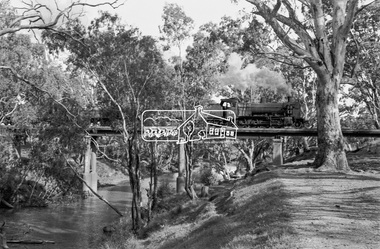
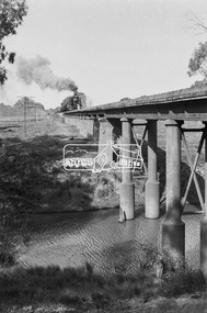
Photograph, Steam locomotive K-158 crossing the railway bridge over the Campaspe River at Rochester, Victoria, c.November 1963, 1963
It is the railway bridge over the Campaspe River at Rochester, Vic. original to the construction of the line. It was taken late on a Saturday morning and shows the regular goods train of that period approaching, then crossing the bridge. I originally planned to take just one view. The approaching train was first then it was a rapid run back along the raised river bank to get the broadside shot. I had little time to steady myself or properly check camera settings, hence the slightly soft focus etc. The train would eventually continue over the Echuca Iron Bridge into NSW. I think its ultimate destination was Deniliquin but not sure.Digital TIFF file Scan of 35mm Ilford FP3 black and white negative transparencygeorge coop collection, k-158, k-class steam locomotive (vr newport workshops), railway bridge, campaspe river, rochester -
 Eltham District Historical Society Inc
Photograph, Steam locomotive K-158 crossing the railway bridge over the Campaspe River at Rochester, Victoria, c.November 1963, 1963
It is the railway bridge over the Campaspe River at Rochester, Vic. original to the construction of the line. It was taken late on a Saturday morning and shows the regular goods train of that period approaching, then crossing the bridge. I originally planned to take just one view. The approaching train was first then it was a rapid run back along the raised river bank to get the broadside shot. I had little time to steady myself or properly check camera settings, hence the slightly soft focus etc. The train would eventually continue over the Echuca Iron Bridge into NSW. I think its ultimate destination was Deniliquin but not sure.Digital TIFF file Scan of 35mm Ilford FP3 black and white negative transparencygeorge coop collection, k-158, k-class steam locomotive (vr newport workshops), railway bridge, campaspe river, rochester -
 Greensborough Historical Society
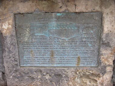
Photograph - Digital image, Dennis Ward, Bridge Plaque - Pioneer Park Greensborough, 27/03/2010
Plaque at Pioneer Reserve Greensborough: "Shire of Diamond Valley. The bluestones used in the construction of this viewing platform and in the carpark entry structure and retaining wall are from the northern arch of Greensborough's first Plenty River Bridge built in the 1860s adjacent to this site. The centre span of the original bridge was removed in 1865 when the western half of the existing bridge was constructed leaving the northern and southern stone arches. The southern arch was retained until floods in 1874 necessitated its removal. The picnic shelter in this reserve was constructed using stone from this abutment. The northern arch was removed in 1983 when widening of the existing bridge commenced."Digital copy of colour photograph.plenty river, pioneer reserve greensborough -
 Eltham District Historical Society Inc
Photograph, Preparing the old Lock-up No. 17 for relocation from Youth Road to the Local History Centre at 728 Main Road, Eltham, March 2001, March 2001
The portable lock up at Eltham is not original to the site. The date of construction is unknown. It is a pre-fabricated design and each of the timber panels are individually numbered on the inside surfaces. It is amongst a large group of portable locks up,categorised as 'Portable Lock Up - Timber - Later' and also known as the "Casterton style", based on the only known plan for portable lock ups, built for the Casterton Police Station, in 1907. The later portables have been in use since the 1880s. It is not known how many lock ups of this type have been constructed in Victoria. At least 50 examples have been documented around the state. Of these, 42 are known to be extant.This lockup used to be located at the Police Station in Pryor Street and was then stored in Youth Road before being acquired for the Local History Centre 9 colour photographseltham, main road, police residence, local history centre, eltham district historical society, courthouse, youth road