Showing 11589 items matching " map"
-
 Tarnagulla History Archive
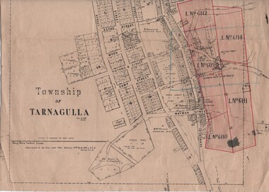
Linen-Backed Map of Tarnagulla Dated 1860 with Updates, Including Mining Leases
This is a very nice linen-backed map first published in 1860 and progressively updated, the latest being 1924 at the time of Government boring on the Poverty Reef. The map clarifies details of the mining leases as they stood in 1924, and the map also identifies previously uncertain details such as the location of the battery well, and also the location of the 1909 syndicate to the south of the Sandy Creek Co's shaft. The lightly pencilled location of the Birthday shaft is incorrect. This mine was located further to the east. -
 Bayside Gallery - Bayside City Council Art & Heritage Collection
Map, Department of Crown Lands and Survey, Melbourne and Suburbs, City of Sandringham, 1917-1926
map, plan, foreshores, sndringham, hampton, beaumaris, cheltenham, department of lands and survey, cartographic material, borough of sandringham, moorabbin, black rock, street map, city of sandringham -
 Whitehorse Historical Society Inc.
Map, Directory Maps of the County of Bourke, 1892
Copies of Directory maps:(i) Title Page, (ii) Preface (iii) Heading section of Map of Melbourne and Suburbs (iv) Parish of Bulleen - includes 'North - East portion of the Parish of Nunawading (v) Village of Burwood. Note: 107(a), 107(b), 107(c) are copies of the same set of sheets.Copies of:(i) Title Page, (ii) Preface (iii) Heading section of Map of Melbourne and Suburbs (iv) Parish of Bulleen - includes 'North - East portion of the Parish of Nunawading (v) Village of Burwood. Note: 107(a), 107(b), 107(c) are copies of the same set of sheets.Copies of Directory maps:(i) Title Page, (ii) Preface (iii) Heading section of Map of Melbourne and Suburbs (iv) Parish of Bulleen - includes 'North - East portion of the Parish of Nunawading (v) Village of Burwood. Note: 107(a), 107(b), 107(c) are copies of the same set of sheets.maps, parish of bulleen, parish of nunawading, burwood -
Whitehorse Historical Society Inc.
Document - Correspondence, Letter and Map Schwerkolt houses, 9/11/1993
Letter to W. Gray, Nunawading Historical Society from Glyn France enclosing map of Schwerkolt property and rough plan of old stone house drawn by Arthur Schwerkolt [map filed at A-SP 120]. Gives information about dates of building 'old' and 'new' houses.schwerkolt, arthur, schwerkolt, myra, france glyn, schwerkolt cottage -
 Federation University Historical Collection
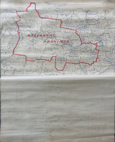
Map, Ballarat Municipalities and City Boundary
Piece of linen attached at top and bottom with wooden rails. Top half of linen has a paper map of Ballaarat Province and Surrounding Municipalities directly attached to it and reads 'Ballaarat Province' in red ink which outlines the greater Ballarat area with surrounding municipalities shown in blue. Scale is '8 miles to 1 inch'. Bottom half is drawn directly onto linen and depicts Ballaarat City Boundary including street names. 'Scale about 20 chains to 1 inch'.ballarat electorate, map, ballaarat province, ballarat to buninyong railway -
 Bendigo Military Museum
Administrative record - International Map of the World (IMW) 1:1 Million Scale - H Ureta, Circa 1964, MR H Ereta, Post 1964
This document records the history of the International Map of the World (IMW) at 1:1Million Scale. Mr H. Ereta, Chief of the Cartographic Section of the United Nations Department of Economic Development and Social Affairs gave a lecture on the IMW and described the history and development of the map series in post 1964. This document is a copy of that lecture. 7 x Foolscap pages of typed text, stapled and two hole punched, Paper is dis-coloured.royal australian survey corps, rasvy, fortuna, army survey regiment, army svy regt, asr, imw -
 Lara RSL Sub Branch
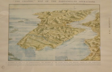
Topagraphical Map of the Dardanelles Operations, Graphic Map of The Dardanelles Operations
WW1, Dardanelles operational map of area of Operations. Military, Naval of the "battering of the Gates of Constantinople"WW! ANZAC, British Military and Naval Operations in the Dardanelles. "battering of the Gates of Constantinople"Graphical representation of the Dardanelle's Operations displaying the Australia & New Zealand and the British operational areas and Landings. Military and Naval involvements in battering the gates to Constantinople.Small circular stamp on front left bottom - "State Library of N.S.W." and on he right hand border " Z M2 390 8/1915/3"ww!, military, naval, battering of the gates of constantinople, australia and new zealand (anzac) -
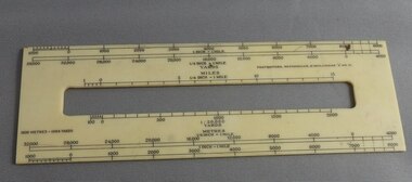 Greensborough Historical Society
Ruler, Scale rule for map reading, 1950c
Small rule to measure distance when reading a scale map. Measurements in yards or meters.Small plastic rule, cream colour with black markings.map reading, scale ruler -
 Whitehorse Historical Society Inc.
Map - Civic Map, Subdivision of Village of Springfield, 1861
Map of the subdivision of the Springfield Estate, Nunawading, 1861. The Springfield Estate was located in the Northwest corner of Whitehorse Road and Springvale Road.Map of the subdivision of the Springfield Estate, Nunawading, 1861. Springfield Estate was located in the Northwest corner of Whitehorse Road and Springvale Road.non-fictionMap of the subdivision of the Springfield Estate, Nunawading, 1861. The Springfield Estate was located in the Northwest corner of Whitehorse Road and Springvale Road.springfield estate, whitehorse road nunawading, springvale road nunawading -
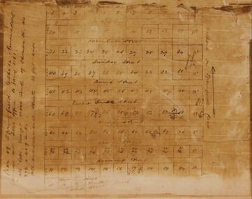
Clunes Museum
Map
.1 - .4 DETAILED MAP OF CLUNES BY F.C.W. .5 MAP OF CLUNESlocal history, documents, maps, maps -
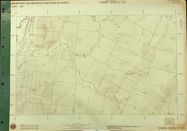 Greensborough Historical Society
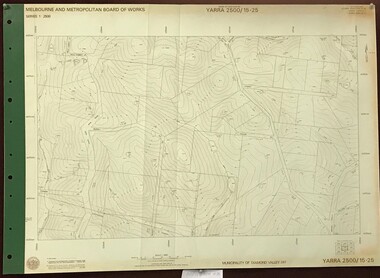
Map, Melbourne and Metropolitan Board of Works. Survey Division, MMBW, Yarra 2500 / 17.25. Hurstbridge, 1978_01
Melbourne and Metropolitan Board of Works. Yarra 2500 [base map] 17-26. Hurstbridge. Municipalities of Diamond Valley 257 and Eltham 238. Prominent streets include: Silvan Road and Hurstbridge Road. MMBW Map in 1:2500 [scale] series. Cream parchment with green tape reinforcing on edges and punched holes on left edge.mmbw, melbourne and metropolitan board of works, shire of diamond valley, hurstbridge - maps -
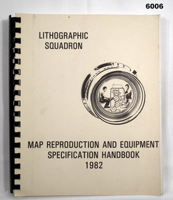 Bendigo Military Museum
Manual - Map Reproduction and Equipment Specification Handbook, 1982
This handbook provided comprehensive technical information principally to the lithographic technician and to other Royal Australian Survey Corps technical trades. Part 1 comprised technical descriptions and photos of lithographic equipment used in military map production. Part 2 provided various tables such as printing sizes conversion tables. Part 3 provided technical guidance on the stipples and screens utilised in the map reproduction process. Part 4 detailed the Pantone Matching System printing colours for map and chart products. Part 5 was a Glossary of Lithographic Technical Terms.Army Survey Regiment Manual/handbook with a manilla cover comprising approximately 100 pages. The pages in the document are in black and white paper providing technical information and photograph identifying lithographic equipment and other information to lithographic technicians. Printed on standard paper bound by a by a black plastic spiral spline.royal australian survey corps, rasvy, fortuna, army svy regt, asr, army survey regiment -
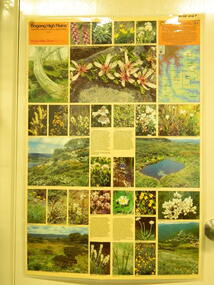 Kiewa Valley Historical Society
Map / Chart, Vegetation Map & Guide to Alpine Flora: Rocky Valley, 1982
This poster is of Rocky Valley is on the Victorian High Plains where the State Electricity Commission of Victoria worked on the Kiewa Hydro Electric Scheme and also where cattlemen brought their cattle up during summer at various times. Its significance is due to it shows the flora of the area after the Kiewa Hydro Electric Scheme Rocky Valley damn has been build and therefore is a valuable for comparison to see what plants are there now after this information on this poster was complied. Historic: Comparison of the flora at Rocky Valley with other areas on the Victorian High Plains and with Rocky Valley before and after the Kiewa Hydro Scheme and / or grazing there. Is therefore research significance and interpretive capacity due to this compatibility value.Laminated double sided vegetation map and guide to the Alpine flora of the Rocky Valley area, with photographs of plants and vegetation.rocky valley. alpine. flora. vegetation. plants. s.e.c.v.. cattlemen. victorian high plains. -
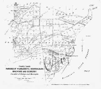 Ringwood and District Historical Society
Photograph, Map-Parishes of Warrandyte, Mooroolbark, Ringwood and Scoresby. 1870
Photograph of map "Country Lands - Parishes of Warrandyte, Mooroolbark, Ringwood and Scoresby - Counties of Evelyn and Mornington" dated 1870. -
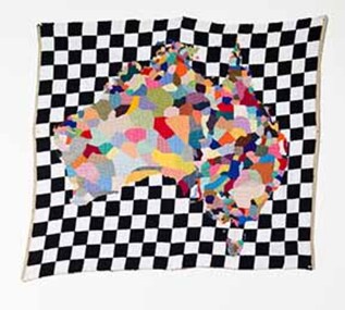 Wangaratta Art Gallery
Textile, Paul Yore, Map, 2012
I see my work with textiles as always a negotiation of both the poetic and the political. A medium often relegated to the realm of ‘craft’, I see working with wool as a subtly subversive methodology, and an opportunity to engage in socio-political critique. As a laborious yet cathartic craft, the delicately feminine familiarity and domestic warmth of my hand-sewn tapestries allows me to open up and question traditional notions of masculinity through the enactment of a highly personalized queer ritual. Furthermore, wool carries with it frontier pastoral associations of early colonial expansion, and it is in this context that the work Map, which is based on the ethnographic mapping of indigenous language groups, was envisioned.contemporaryWangaratta Art Gallery Collection. Work acquired as winner of 2013 Wangaratta Contemporary Textile Award. Digital reproduction courtesy of the artist, Neo Parc Melbourne and Hugo Michell Gallery Adelaide.A rectangular wool needlepoint textile work that features a multi-coloured map of Australia on a black and white checkered background. textile, wcta, wangaratta art gallery, paul yore, wool needlepoint -
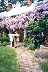 Whitehorse Historical Society Inc.
Photograph, Launch of Valley of the Arts Tourist Map, 1/10/2000 12:00:00 AM
Coloured Photo of President of the Valley of the Arts Committee speaking at the launch of the Valley of the Arts Tourists Map at Schwerkolt Cottage.valley of the arts, schwerkolt -
 Ringwood RSL Sub-Branch
Book, Manual of Map Reading, 1955
Hard cover book with fold out maps with 132 printed pages text. Author - The War Office 1955Airphoto reading, Field sketching. -
 Ballan Shire Historical Society
Map - Map. Ballark, Department of Lands and Survey, Ballark. County of Grant, 31/08/1915
A map of the Ballark area within the County of Grant showing roads, waterways, property boundaries and property owners in 1915.Significant to people researching land usage and ownership. Also those researching families in the area at that time.A map of Ballark in the County of Grant. Black printing on buff coloured paper. Extra notations by hand and various coloured highlighting of certain features. Details roads, rivers, property boundaries and names of property owners and districts. The map is easily readable although there is some physical damage to the borders and some sellotape residue. Shows a scale in Chains and the number L.6030Various numbers and directional arrows added to map.bungal, borhoneyghurk, bungeeltap, ballark, beremboke, moreep, meredith, morrisons, moorarbool river -
Tatura Irrigation & Wartime Camps Museum
Document, Map of encounter
Map of encounter between HMAS "Sydney" and HSK "Kormoran" copied from Captain Detmer's book. -
 Stawell Historical Society Inc
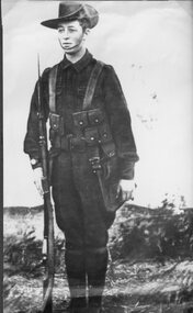
Photograph, Mr Sydney Davidson as a Soldier in WW1 in uniform with rifle, webbing, & map case 1914-1918 -- Studio Portrait
Portrait Sydney Davidson 1914-18 Soldier WW1 in uniform with rifle webbing and map casestawell war -
Tatura Irrigation & Wartime Camps Museum
Map, State Rivers and Water Supply Commission, Goulburn Irrigation System, C 1940
A map showing the extent of Goulburn irrigation C. 1940. Also indicated by shading are: natural water resources, proposed extensions, existing stock and domestic supply areas, reservoirs, main channels, principal distribution channels, and railways.Irrigation Rivers Victoria.irrigation, victoria state rivers and water supply commission, map -
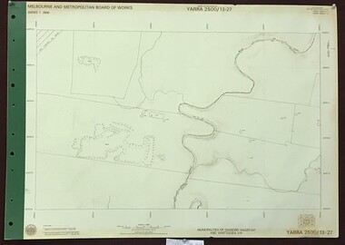 Greensborough Historical Society
Map, Melbourne and Metropolitan Board of Works. Survey Division, MMBW, Yarra 2500 / 13.27. Morang wetlands, 1977_09
Melbourne and Metropolitan Board of Works. Yarra 2500 [base map] 13.27. Morang wetlands. Municipality of Diamond Valley 257 and Whittlesea 239. Features include the Plenty River and SEC Transmission Line easement. MMBW Map in 1:2500 [scale] series. Cream parchment with green tape reinforcing on edges and punched holes on left edge.mmbw, melbourne and metropolitan board of works, shire of diamond valley, morang - maps -
 Federation University Historical Collection
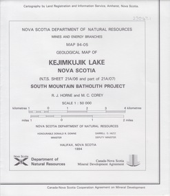
Map - Geological, Nova Scotia Department of Natural Resources, Kejimkujik Lake, Nova Scotia: Geological Map 94-05, 1994
Produced b Nova Scotia Department of Natural Resources, Mines and Energy Branches. The Minister of the Department was the Honourable Donald R Downe and the Deputy Minister was Darrell D HiltzLarge coloured map depicting different areas and deposits. Includes a legend, symbols used, mineral abbreviations and alteration abbreviations.Symbolsnova scotia, kejimkujik lake, geological survey, cartography, mine and energy branches, donald r downe, minister, darrell d hiltz, deputy mnister, south mountain batholith project, legend, symbols -
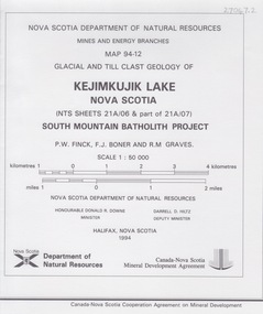 Federation University Historical Collection
Map - Geological, Kejimkujik Lake, Nova Scotia: Glacial and Till Clast Geology: Map 94-12, 1994
Produced b Nova Scotia Department of Natural Resources, Mines and Energy Branches. The Minister of the Department was the Honourable Donald R Downe and the Deputy Minister was Darrell D HiltzLarge coloured map depicting different areas and deposits. Includes a legend, symbols used, mineral abbreviations and alteration abbreviations.Symbols -
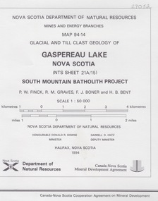 Federation University Historical Collection
Map - Geological, Gaspereau Lake, Nova Scotia: Glacial and Till Clast Geology: Map 94-14, 1994
Produced by Nova Scotia Department of Natural Resources, Mines and Energy Branches. The Minister of the Department was the Honourable Donald R Downe and the Deputy Minister was Darrell D HiltzLarge coloured map depicting different areas and deposits. Includes a legend, symbols used, mineral abbreviations and alteration abbreviations.Symbolsnova scotia, department of natural resources, mines and energy branch, donald r downe, minister, darrel d hiltz, deputy minister, glacial and till clast, geo;logy, south mountain batholith project -
 Greensborough Historical Society
Map, Melbourne and Metropolitan Board of Works. Survey Division, MMBW, Yarra 2500 / 16.22. Research, 1979_05
Melbourne and Metropolitan Board of Works. Yarra 2500 [base map] 16-22. Research. Parish of Nillumbik 3310. Municipalities of Diamond Valley 257 and Eltham 238. Prominent streets include: Orme Road and Allendale Road. MMBW Map in 1:2500 [scale] series. Cream parchment with green tape reinforcing on edges and punched holes on left edge.mmbw, melbourne and metropolitan board of works, shire of diamond valley, diamond creek - maps -
 Greensborough Historical Society
Map, Melbourne and Metropolitan Board of Works. Survey Division, MMBW, Yarra 2500 / 15.25. Yarrambat, Black Gully Road, 1978_07
Melbourne and Metropolitan Board of Works. Yarra 2500 [base map] 15.25. Yarrambat, Black Gully Road. Municipality of Diamond Valley 257. Prominent streets include: Black Gully Road, Ironbark Road and Murray Road. MMBW Map in 1:2500 [scale] series. Cream parchment with green tape reinforcing on edges and punched holes on left edge.mmbw, melbourne and metropolitan board of works, shire of diamond valley, yarrambat - maps -
 Bendigo Military Museum
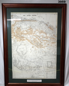
Map - MAP, NEW GUINEA FRAMED, C. 1941 onwards
Map of central section of New Guinea. Black print on white background with mountain ridges in tan. Map is mounted with green border. Brown wooden frame, glass front, white cardboard backing with wire hanging strap on back. Map prepared under the direction of RAAF Headquarters.Printed in black top centre: “NEW GUINEA CENTRAL” Printed on border under map: “These escape maps were carried in the zip pocket of life jackets by fighter pilots in WW2. This map was presented to A.S.R. on 12.7.79 by Councillor Ian McKenzie, Mayor of Eaglehawk, who served as a fighter pilot in 78th SDN in the SW Pacific area during 1943-44.”map, new guinea, central, raaf -
 Bendigo Military Museum
Manual - TM5 - 245: (US) Department of the Army Technical Manual - Map Reproduction, US Department of the Army, United States of America, War Office, 10 Sep 1956
Nine Chapters describing all aspects of Map Reproduction. 224 pages, including 8 appendices, glossary and indexA soft covered military manual, 224 pages of text, diagrams and annotated photographs"AHQ Survey Regiment" stamped inside front and back covers. Number "149" handwritten inside front cover.royal australian survey corps, rasvy, fortuna, army survey regiment, army svy regt, asr, mapping -
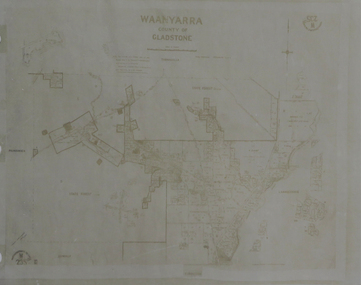 Federation University Historical Collection
Map, Waanyarra, not dated
Photocopy of mapwaanyarra