Showing 625 items
matching along the way
-
 Melbourne Tram Museum
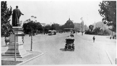
Photograph - Black and White - St Kilda Road near City Road
Photo 1 - looking north from the point where St Kilda Road widened after crossing Princes Bridge. Has the Edmund Fitzgibbon monument on the left. One cable tram set is making its way into the City. Has Flinders St Station in the background, along with a number of motor cars and one horse drawn vehicle behind the monument and another behind a sign. In the far distance is an advertisement for The Herald newspaper. Photo 1910c Photo 2 - looking south from near the end of the bridge, with seven cable cars in the view, along with motors cars and two horse drawn vehicles. Government House can be seen on the left horizon.Yields information about St Kilda Road c1910.Set of two black and white photographs of" .1 - St Kilda Road near City Road looking north - with Edmund FitzGibbon monument .2 - looking southtramways, trams, cable cars, flinders street station, st kilda road, princes bridge, monuments, edmund fitzgibbon -
 Bendigo Historical Society Inc.
Newspaper - JENNY FOLEY COLLECTION: HISTORY
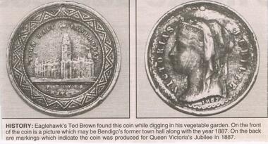
BHS CollectionBendigo Advertiser ''The way we were'' from 2003. History: Eaglehawk's Ted Brown found this coin while digging in his vegetable garden. On the front of the coin is a picture which may be Bendigo's former town hall along with the year 1887. On the back are markings which indicate the coin was produced for Queen Victoria's jubilee in 1887. The clip is in a folder.newspaper, bendigo advertiser, the way we were -
 Ballarat Tramway Museum
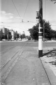
Negative - Corner Drummond and Sturt Street tram stop, Laurie Gallop, mid 1950s
Photo shows the inbound tram stop pole on the Northwest corner of Sturt and Drummond Streets in Ballarat. Note the vertical "End Section" sign along with the usual "End of Section" and "Cars stop here" sign at this compulsory tram stop. Another stop can be see on the other side of Drummond St along with No. 14 on its way to the City. Yields information about the tram stop at the corner of Sturt and Drummond St and signage.Black and white Negative - 120 sizetram stops, tramways, sturt st, drummond st, end of section sign, tram stop, sign -
 Eltham District Historical Society Inc
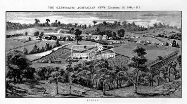
Photograph, Samuel Calvert, Eltham, The Illustrated Australian News, December 26, 1884, p212, 1884
A description in the newspaper near the illustration (page 210) reads as follows: "Eltham is a pretty little township on the Yarra Flats road, about 14 miles east north east of Melbourne, from which place there is communication by way of Heidelberg. It has a population of nearly 400 inhabitants, but in addition it is the centre of a large district extending over about 203 square miles, having a population of 2344. The land in the district is mostly used for grazing purposes, although as a rule the small farms grow a good deal of wheat, oats and other agricultural produce. A large quantity of fruit, especially raspberries and strawberries, is also produced, the rich alluvial flats along the creek upon which the township is situated being very well adapted for that purpose. Gold has also been found in the vicinity of the township, but not in remunerative quantities". This photo forms part of a collection of photographs gathered by the Shire of Eltham for their centenary project book,"Pioneers and Painters: 100 years of the Shire of Eltham" by Alan Marshall (1971). The collection of over 500 images is held in partnership between Eltham District Historical Society and Yarra Plenty Regional Library (Eltham Library) and is now formally known as 'The Shire of Eltham Pioneers Photograph Collection.' It is significant in being the first community sourced collection representing the places and people of the Shire's first one hundred years.Digital imageshire of eltham pioneers photograph collection, eltham, illustrated australian news -
 Stawell Historical Society Inc
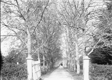
Photograph, “The Sycamores” Driveway entrance Gates
Entrance gates to “The Sycamores” Driveway. A show place on Concongella from mid 1860's. "The Sychmores" where William Osmand lived. Osmand's "Sycamores" was in a secluded block of the eastern side of the creek along which was planted pine and cypress trees. He built a comfortable house and line the carriage way with Sycamores. Osmand was on the of the men who made money in the Stawell reefs mines. "The Sycamores" has been owned by the West family since c 1920. Black & white photograph (2 copies) of an entrance gateway with an avenue of deciduous trees.concongella -
 Sunbury Family History and Heritage Society Inc.
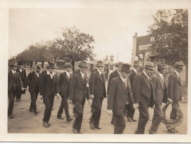
Photograph, Anzac March, C1930s
The group of men in the photograph were marching in file along Brook Street and were making their way to the War Memorial in Stawell Street. They were approaching the intersection of Brook, O'Shanassy and Stawell Streets, known locally as the 5 ways. A non-digital sepia photograph with a cream border of men dressed in suits and hats marching in file along a tree-lined street. One man holds a wreath to place on a memorial. A service station with petrol pump are to the RHS of the photograph.The words 'Kodak Print' and S579 are stamped on the back of the photograph.war memorials, anzac day, brook street, stawell street, o'shanassy street, marches -
 Mont De Lancey
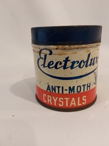
Functional object - Electrolux Tin, Electrolux Pty Ltd, mid 1900's
The Anti-moth crystals were sold with the Electrolux Vacuum, along with the many other attachments, including the vaporiser. The crystals were made of paradichlorobenzene which is used in mothballs. Electrolux, founded in Sweden, has been manufacturing vacuum cleaners since 1919. On the back of the tin - 'Poisonous - Not to be taken - Electrolux Pty. Ltd., Melbourne - When used in conjunction with the vaporiser supplied with the Electrolux cleaner in this tin, Electrolux anti-moth crystals will destroy moths and moth larvae and are also effective against silverfish and other similar pests. Crystals or vapour will not harm fabrics in any way. Keep tin in cool place. - Kills Moths'A small empty vintage red, white and blue round lidded tin, 'Electrolux Anti-Moth Crystals'. The brand is printed in blue text on the middle white and red bands of the tin, with a moth shape included. The manufacturer is printed inside a white star shape on the blue lid. Detailed instructions for use is printed on the back in blue and red lettering. 'Electrolux Anti-Moth Crystals'. On the back of the tin printed in red 'POISONOUS - Not to be taken Electrolux Pty. Ltd. Melbourne' Full details for use is also provided. vacuum cleaners, cleaning equipment, domestic equipment, electrolux -
 Bendigo Historical Society Inc.
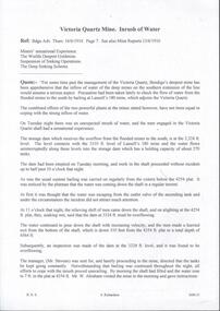
Document - DRAINAGE PROBLEMS - INRUSH OF WATER AT THE VICTORIA QUARTZ
Two handwritten copies of a Bendigo Advertiser report 16/6/1910 Page 7. This is a longer version of 3600.14. It was thought that the rush of water was from a dam bursting in one of the other mines, but as the water showed no signs of slowing that theory was discarded. The temperature of the incoming water was much higher than the Victoria Quartz was accustomed to bail, and this circumstance is significent in view of the increased temperature of the water at the deep levels in the New Chum Railway. Some months ago, the water commenced to flow from the New Chum Railway workings into the New Shenandoah, which is the next mine north. The water rose so rapidly that a disaster was narrowly averted. The mines along the line were connected at different levels and with the cessation of bailing at the deep levels in the southern mines, it was only to be expected that the water would find its way north to the Victoria Quartz. The water raised from the operating mines under the direction of the New Chum Drainage Association, a yeart or two ago used to exceed six million gallons per month. At that time there were eight companies bailing water, and even then some of the plants, especially those at the deep mines, were severely taxed in coping with the water, and performing ordinary work. Since some mines had discontinued bailing, the water has been filling up extensive workings, and as was predicted in the ''Advertiser'' some time ago, the Victoria Quartz Company could not expect to succeed with its deep sinking project without making some special provision for raising the water, which ultimately would become a source of trouble. The Victoria Quartz Company was allotted a special grant of 10,000 pound to assist in sinking the shaft 1000 ft from the 4254 ft level. Under the conditions of the grant, the Company had to contribute half the cost of the sinking, and the raising of the water has also been an exensive item. For the present, all attention will be concentrated in lowering the water, and should the appliances prove unequal to the task the deep sinking scheme can only be accomplished by resorting to some comprehensive system of combating the water'. Document from Albert Richardson Collection of mining history.document, gold, drainage problems, drainage problems, inrush of water at the victoria quartz, bendigo advertiser 16/6/1910 page 7, mine reports 13/6/1910, victoria quartz, lansell's 180, mr stevens, mr w abraham, new chum & victoria mine, new chum railway, new shenandoah, new chum drainage association -
 Bendigo Historical Society Inc.
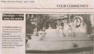
Newspaper - JENNY FOLEY COLLECTION: FLOATING ALONG
BHS CollectionBendigo Advertiser ''The way we were'' from Tuesday, April 8, 2003. Floating along: the post office float during the 1939 Bendigo Easter Fair procession. Back row: Cath Thompson and Joan Bool. Front row: Lena Cullen and Windfred Ryan. Queen: Marjorie Mollard. Page girls: names unknown. The clip is in a folder.newspaper, bendigo advertiser, the way we were -
 Melbourne Tram Museum
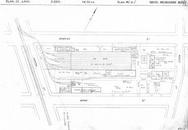
Drawing, Melbourne & Metropolitan Tramways Board (MMTB), "South Melbourne Depot", c1937
Set of five photocopied plans or drawings on A3 sheet of "South Melbourne Depot" - c 1937 .1 - P8345 - Plan of land showing MMTB land and surrounding properties. .2 - P8346 - Plan of land showing detail of offices .3 - P8347 - Plan showing detail of tram shed and adjacent buildings .4 - P8348 - Plan showing detail of buildings along the side of the block. .5 - P8349 - Plan showing details of the per way yard and associated facilities.trams, tramways, drawings, depots, property, south melbourne depot -
 Melbourne Tram Museum
Pamphlet, The Met, "Low Floor light rail for the Upfield line - it is a better way to go", c1989
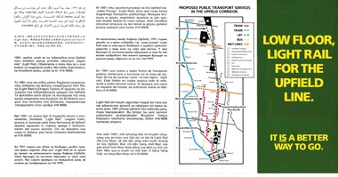
Pamphlet - four fold DL size full colour titled "Low Floor light rail for the Upfield line - it is a better way to go", explaining or providing advice on the proposal for the conversion of the Upfield line to Light rail and timing. Has a map of the proposal - has a translation in 11 languages. Includes a map showing the proposals, project details, why, level crossings, rail services and timing and proposals for a shuttle along Sydney Road. Second copy added 17-7-2017.trams, tramways, light rail, upfield light rail, conversion, sydney rd -
 Melbourne Tram Museum
Pamphlet, Rail Projects Victoria, "MetroTunnel Newsletter", May. 2018
Pamphlet Series of 8 printed and digital documents - titled "MetroTunnel Newsletter issued by Rail Projects Victoria (formally Melbourne Metro Rail Authority). Reports on the changes to the Domain Intersection tram stops, track relocation during Easter 2018 and that the Tunnel boring machines are on the way. The machines are compared to the length and weight of E class trams. Includes station names Anzac Station. Has the logos of the State of Victoria and Rail Projects Victoria. Previous issues: down loaded from the Metro Tunnel website 22-10-2018 Issue 01 - June 2015 - i1.pdf 02 - December 2015 - i2.pdf 03 - May 2016 - i3.pdf 04 - May 2017 - i4.pdf 05 - October 2017 - i5.pdf 06 - May 2018 - i6.pdf - folded A3 sheet - Reports on the changes to the Domain Intersection tram stops, track relocation during Easter 2018 and that the Tunnel boring machines are on the way. The machines are compared to the length and weight of E class trams. Includes station names Anzac Station. 07 - October 2018 - i7.pdf - folded A3 sheets - reporting on work at Federation square and the station locations, some before and after photos and archaeological digs. 08 - September 2019 - i8.pdf - folded A3 sheet - report on traffic changes in Flinders St, the Tunnel boring machines, North Melbourne Station, progress at various sites. 09 - February 2021 - i0.pdf - folded A3 sheet, report on the tunnelling machine progress and a list of dates during 2020 along with notes on the Airport rail line.trams, tramways, metro tunnel, e class, domain interchange, domain junction, anzac station -
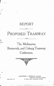 Melbourne Tram Museum
Document - Photocopy, Valentine J. Crowley Consulting Engineer, "Report on Proposed Tramway for The Melbourne, Brunswick and Coburg Tramway Conference", Original 1915
Photocopy - Report - 12 pages - titled "Report on Proposed Tramway for The Melbourne, Brunswick and Coburg Tramway Conference", prepared by Valentine J. Crowley Consulting Engineer Oct. 25, 1915. Looks at the construction of a tramway Flinders St along Queen St, to Royal Park, to Sussex St and Gaffney Road, West Coburg for the Melbourne Brunswick and Coburg Tramways Trust. Looks at the route and length of track in detail, route, administration, population, construction, permanent way, overhead lines, feeders, rolling stock, timetable, capital cost, alterations to services, expenditure for year and conclusion. Has a map of the proposed route. Included with the document is a plan of the MBCTT lines, overwritten in ball point pen with street names dated Dec. 1919. Photocopy made from original documents - has been stapled along the side in three places.trams, tramways, mbctt, maps, new tramway, west coburg, queen st, royal park -
 Melbourne Tram Museum
Newspaper, Leader Northcote, Melbourne Herald, " Campaign for Bourke St trams", " Those Trams" and "One way ahead", 1980 - 1981
Series of five news paper cuttings regarding tram operation in the CBD and in particular along Bourke St. Each cutting has the Aust. Press Cuttings Agency source sheet pasted to the top left hand corner along with the paper name and date stamp. .1 - Leader Northcote - 22/7/1981 - " Campaign for Bourke St trams", written by Ian Munro, regarding a proposal by the City Commissioners to remove trams from Bourke St and run via Lonsdale St. .2 - Melbourne Herald - 18/8/1981 - "Those Trams", editorial regarding the possibility of removing trams from Bourke St. .3 - as for .2, but a short piece - just the last paragraph of .2 .4 - Melbourne Herald - 10/9/1981 - editorial titled "One way ahead" about the possibility of a converting some city streets to one way, a ring road and traffic flows. Noted the "MMTB juggernauts". .5 - Melbourne Herald - 8/11/1980" - titled "Shut half of streets - expert" reporting that an American design consultant - Desmond Muirhead - about shutting streets to traffic, keeping trams as in the Bourke St Mall - uses Munich as an example.Some have In pencil "Ballarat Trams" in top left hand corner.trams, tramways, bourke st, lonsdale st, city of melbourne, mmtb, traffic control -
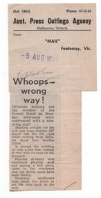 Melbourne Tram Museum
Newspaper, Mail Footscray, "Whoops - wrong way", 5/08/1981 12:00:00 AM
Newspaper cutting from the Mail Footscray about W2 227 derailing while turning from Ballarat Road into Gordon St and heading towards the Power Hotel on the Monday (3/8/1981) afternoon. Titled "Whoops - wrong way" See also Reg item 1639 for its subsequent sale to a Lilydale property, though this may not be correct - a check with the tramcar card shows that it was withdrawn and sold during July 1981 and that Z3 227 did not enter service until 1984. Cuttings has the Aust. Press Cuttings Agency source sheet pasted to the top right hand corner along with the paper name and date stamp.Has in pencil at top of cutting "MT/Ballarat Trams"trams, tramways, accidents, mmtb, footscray, ballarat rd, gordon st, w2 class, tram 227 -
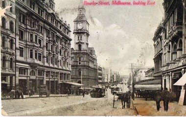 Melbourne Tram Museum
Postcard, Marlborough Series, "Burke St Melbourne Looking East", c1910
Postcard photo of Bourke St looking east from about half way between Elizabeth and Queen St with the Melbourne GPO, Post Office in the middle of the photograph, along with a number of horse drawn vehicles and cable trams. mid 1900's (c1905). Divided back with spaces for Correspondence, address and stamp. On right hand side in red "Marlborough Series" (Printed in Australia)trams, tramways, cable trams, bourke st, horse drawn vehicle -
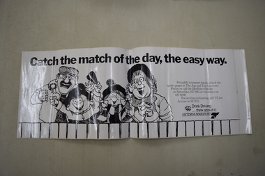 Melbourne Tram Museum
Poster - The Met "Catch the match of the day" Adhesive Poster, The Met, c.1980s
Used as advertised public information on the interior of vehicles to encourage football patrons in particular to use public transport, rather than drive to the venues. Also promotes not drinking and then driving a car afterwards.An advertising/public information publication that is associated with a now-dissolved corporate body which existed in the 1980s and promoting the use of public transport.A black-and-white adhesive poster that advertises public transit services (e.g., The Met, V/Line) for people attending sports events in Melbourne, in particular the AFL or Football. The title reads, "Catch the match of the day, the easy way." Phone numbers and publications that provide relevant information are mentioned, along with a logo for Victoria Transport which discourages drink driving. The brand of the adhesive (JAC) is printed on the adhesive-covering paper on the reverse side.public transport, the met, posters, v-line, drink-driving, football -
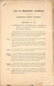 Melbourne Tram Museum
Document - Specification, City of Melbourne Tramways, "Hawthorn Horse Tram", 1880s
Contract No 52 - Specification of materials to be supplied, and works to be performed, in the construction of the Hawthorn Tramway. The contract embraces the excavation, laying down of permanent way, metalling, paving, and every detail complete as shown in the drawings. The contract commences at the Hawthorn Terminus of the Richmond Cable Tramway and extends along Burwood Road, Power Street, Riversdale Road and terminates at Glenferrie Road. Total length 1 mile, 52 chains and 25 links. Contract No 109 - as per above, except for termination at Auburn Road. Total length 67 chains and 50 links. .trams, tramways, horse trams, tenders, trackwork -
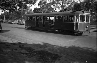 Melbourne Tram Museum
Negative, Wal Jack, 10/02/1941 12:00:00 AM
Black and white negative, by Wal Jack, of No.CW5 684 Batman Ave on its way to Burwood. Has the Yarra River and the Gardens in the background. The tram is well loaded. Photo dated 10-2-1941 in the Wal Jack album along with details of the location.trams, tramways, batman ave, cw5 class, burwood, tram 684, route 74, mmtb -
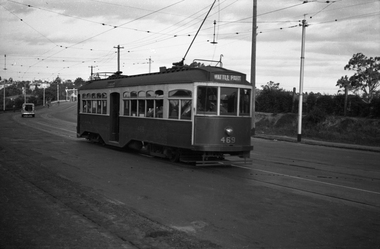 Melbourne Tram Museum
Negative, Wal Jack, 10/02/1941 12:00:00 AM
Black and white negative, by Wal Jack, of Y 469 outbound in Swan St Burnley or Richmond, on its way to Wattle Park. Photo dated 10-2-1941 in the Wal Jack album along with details of the location.trams, tramways, swan st, burnley, y class, wattle park, tram 611 -
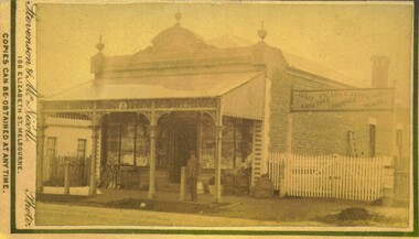 Bacchus Marsh & District Historical Society
Photograph, Pearce Brothers Store Main Street Bacchus Marsh 1883
This store was built in 1881 and opened as a branch of Pearce Brothers main store which was further along in Main Street, Bacchus Marsh. The store in this image opened around early June 1881 and was described in the Bacchus Marsh Express as "quite above the usual standard of stores in towns of a similar or even much larger size. The building is most substantially built of brick, and measures 58 feet by 26 feet, with walls fourteen feet high inside. The interior is most elaborately fitted with shelves and glass cases covering both side walls and two ends formed by small offices separated from the main store by glass and wood panelled partitions, with a passage way between to the storeroom at the rear", Express, (Bacchus Marsh, 11 June, 1881, page 2). The building was designed by one of its proprietors T. G. Pearce and was entirely constructed by local contractors and workers.Small sepia unframed photograph on card with gold border framing photograph. Housed in the album, 'Photographs of Bacchus Marsh and District in 1883 by Stevenson and McNicoll'. The image depicts a general store with a double-front of windows. Goods such as spades, shovels, tubs and wringers are arrayed on the footpath in front of the store. At the front of the shop under a verandah stands a man, possibly one of the Pearce brothers who owned this business. Next to the store is a vacant block of land with a white picket fence. A sign erected above the fence advertises: “ Pearce Bros. Chaff. Hay & Oats. Produce. Dealer. “On the front: Stevenson & McNicoll. Photo. 108 Elizabeth St. Melbourne. COPIES CAN BE OBTAINED AT ANY TIME. On the back: LIGHT & TRUTH inscribed on a banner surmounted by a representation of the rising sun. Copies of this Portrait can be had at any time by sending the Name and Post Office Money Order or Stamps for the amount of order to STEVENSON & McNICOLL LATE BENSON & STEVENSON, Photographers. 108 Elizabeth Street, MELBOURNE. pearce family bacchus marsh, general stores bacchus marsh, shops bacchus marsh, pearce brothers general store bacchus marsh, stevenson and mcnicoll 1883 photographs of bacchus marsh and district -
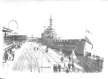 Port Melbourne Historical & Preservation Society
Photograph - HMS Repulse, outer west Princes Pier, Port Melbourne, C W Ward, Mar 1924
HMS Repulse was on a good-will visit, showing the flag of Great Britain. She came from Adelaide and was on her way to Hobart. [This photo as well as 3354.01 - .05 and 3361 came to PMHPS from the Moe Historical Society via the St Kilda Historical Society. Notations in pencil on the back along the left had edge indicate they came from "C W Ward photo, 355 High St, Prahran, Melbourne". Each photo bears the date 9-12-1947 in the top left corner. It is not known what this date refers to. Possibly it is when the photo was printed. Another notation on each photo says "Port Melbourne, taken in 1920". This is definitely incorrect and "NOT" has been written underneath this comment.]Black and white photograph of HMS Repulse at the outer West Princes Pier between 17-25 March 1924transport - shipping, piers and wharves - princes pier, hms repulse -
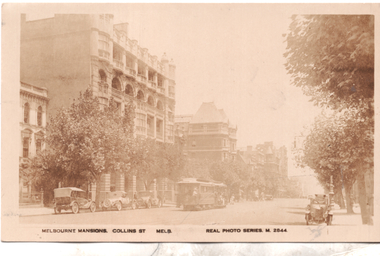 Melbourne Tram Museum
Postcard, Valentine's, "Melbourne Mansions Collins St Melb", 1919c
Postcard Real photo number M2844, titled "Melbourne Mansions Collins St Melb", by Valentine Sons. Featuring a west bound cable tram set in Collins Street between Exhibition and Russell Streets bound for Spencer Street, The trailer car appears to be No 52 and also has a non-standard destination box fitted on the side. The Melbourne Mansions Building. 91 - 101 Collins Street, was funded by David Syme proprietor of The Age newspaper and built in 1906. It is thought to be the first block of residential flats within the city limits. The building was demolished in 1958 to make way for Consolidated Zinc Building (CRA) completed in 1962. but since demolished. The large building further along Collins Street is the Austral Building completed in 1891. There are several parked cars and horse drawn wagons on the south side of Collins Street and an early Morris Oxford (Bullnose) on the northside. Behind that is one of the early ornate electric street lighting poles of the era. The photo has been taken around 1919 as the fourth floor addition to The Alexandra Club is visible in the photo. Unfortunately this particular copy of the photo has faded over time.Demonstrates a Valentine and Sons Real photograph postcard.Postcard - Real photograph - divided back unused.cable trams, collins st, tramways, tram 52 -
 Eltham District Historical Society Inc
Photograph, Looking north across the Fitzsimons Lane Bridge over Yarra River between Eltham and Templestowe, c.1985, 1985c
Turnoff to Candlebark Park on right. The bridge over the Yarra River was initially opened September 22nd, 1961. Newspaper reports at the time of opening stated it linked Bolton Street, Eltham, with Fitzsimons Lane, Templestowe. In 1955 the Country Roads Board (CRB) produced survey plans that showed proposed land acquisition for the future bridge and road approaches. The 1955 plan shows that it was proposed to connect Fitzsimons Lane with Bolton Street in Eltham by a diagonal road across the river. The road connection would then continue along Bolton Street to Main Road. Prior to construction of the bridge the CRB modified the proposal significantly so that there was a new road parallel with Bolton Street and then curving to join Main Road at what was then its intersection with Old Eltham Road. This involved significantly more land acquisition and altered the pattern of land subdivision through this corridor. Initially the new road was just a single two-way carriageway as it would have required a significant widening of the cutting on the Shire of Eltham side of the river. The road was officially un-named but was known locally as the Eltham-Templestowe Road. The 1966 Melway street directory and other 1960s editions also listed the road as the Eltham-Templestowe Road. In December 1970, Eltham Shire Council, in pursuance of the provisions of the Local Government Act, named it Templestowe Road. The road was renamed Fitzsimons Lane around 1984 in conformity with the section south of the river. In 1991 a new bridge was built to the west of the original bridge. Fitzsimons Lane was widened to four traffic lanes although on the Eltham side this was done within the limits of the existing cutting. NEW BRIDGE STARTS THEM EXPLORING Without any fanfares, Country Roads Board workmen on Friday afternoon put the finishing touches to the approaches, removed the barricades, and let the traffic roll over the new Yarra bridge linking Bolton Street, Eltham, with Fitzsimons Lane, Templestowe. Over the week-end many “bridge watchers” who were making one of their periodic inspections of the progress on the new bridge found to their surprise that they could drive over it, so that people who had gone for a run out to Eltham suddenly found themselves wandering through Templestowe and Doncaster. By Monday the word of the bridge’s opening had got around sufficiently for many regular travellers to the city from Eltham and beyond to vary the monotony by going to town via Templestowe and Kew instead of through Heidelberg. They were surprised at the distances – about 3 ½ miles from Eltham to Templestowe, 6 miles from Eltham Shire hall to the Lower Heidelberg Road-Banksia Street intersection. NEW NEIGHBOURS For people on both sides of the river, the new bridge has turned distant friends into near neighbours. A Greensborough man on Sunday took 35 minutes to reach the home of a friend in East Doncaster, but the return trip over the new bridge took only 17 minutes. It will be some time yet before most people work out the possibilities in shorter and quicker trips form the north-eastern areas to the eastern and south-eastern suburbs. The coming of the warmer months will soon teach many, though the short cuts to Peninsular beaches and eastern suburban drive-ins. And before very long it is likely there will be a Tramways bus running from Templestowe to Eltham station. NEW BRIDGE STARTS THEM EXPLORING (1961, September 27). The Diamond Valley News (News clipping held in SEA_74-1_047) The previously un-named road between Main Road and Yarra River, Eltham South, east of Bolton Street was named Templestowe Road, December 15, 1970 NAMING OF STREETS AND ROADS. (1970, December 15). The Diamond Valley News (News clipping held in SEA_74-2_022)Colour photographinfrastructure, shire of eltham infrastructure, bridge, fitzsimons lane bridge, yarra river, candlebark park, red nose day -
 Eltham District Historical Society Inc
Photograph, Fitzsimons Lane Bridge over Yarra River between Eltham and Templestowe
The bridge over the Yarra River was initially opened September 22nd, 1961. Newspaper reports at the time of opening stated it linked Bolton Street, Eltham, with Fitzsimons Lane, Templestowe. In 1955 the Country Roads Board (CRB) produced survey plans that showed proposed land acquisition for the future bridge and road approaches. The 1955 plan shows that it was proposed to connect Fitzsimons Lane with Bolton Street in Eltham by a diagonal road across the river. The road connection would then continue along Bolton Street to Main Road. Prior to construction of the bridge the CRB modified the proposal significantly so that there was a new road parallel with Bolton Street and then curving to join Main Road at what was then its intersection with Old Eltham Road. This involved significantly more land acquisition and altered the pattern of land subdivision through this corridor. Initially the new road was just a single two-way carriageway as it would have required a significant widening of the cutting on the Shire of Eltham side of the river. The road was officially un-named but was known locally as the Eltham-Templestowe Road. The 1966 Melway street directory and other 1960s editions also listed the road as the Eltham-Templestowe Road. In December 1970, Eltham Shire Council, in pursuance of the provisions of the Local Government Act, named it Templestowe Road. The road was renamed Fitzsimons Lane around 1984 in conformity with the section south of the river. In 1991 a new bridge was built to the west of the original bridge. Fitzsimons Lane was widened to four traffic lanes although on the Eltham side this was done within the limits of the existing cutting. NEW BRIDGE STARTS THEM EXPLORING Without any fanfares, Country Roads Board workmen on Friday afternoon put the finishing touches to the approaches, removed the barricades, and let the traffic roll over the new Yarra bridge linking Bolton Street, Eltham, with Fitzsimons Lane, Templestowe. Over the week-end many “bridge watchers” who were making one of their periodic inspections of the progress on the new bridge found to their surprise that they could drive over it, so that people who had gone for a run out to Eltham suddenly found themselves wandering through Templestowe and Doncaster. By Monday the word of the bridge’s opening had got around sufficiently for many regular travellers to the city from Eltham and beyond to vary the monotony by going to town via Templestowe and Kew instead of through Heidelberg. They were surprised at the distances – about 3 ½ miles from Eltham to Templestowe, 6 miles from Eltham Shire hall to the Lower Heidelberg Road-Banksia Street intersection. NEW NEIGHBOURS For people on both sides of the river, the new bridge has turned distant friends into near neighbours. A Greensborough man on Sunday took 35 minutes to reach the home of a friend in East Doncaster, but the return trip over the new bridge took only 17 minutes. It will be some time yet before most people work out the possibilities in shorter and quicker trips form the north-eastern areas to the eastern and south-eastern suburbs. The coming of the warmer months will soon teach many, though the short cuts to Peninsular beaches and eastern suburban drive-ins. And before very long it is likely there will be a Tramways bus running from Templestowe to Eltham station. NEW BRIDGE STARTS THEM EXPLORING (1961, September 27). The Diamond Valley News (News clipping held in SEA_74-1_047) The previously un-named road between Main Road and Yarra River, Eltham South, east of Bolton Street was named Templestowe Road, December 15, 1970 NAMING OF STREETS AND ROADS. (1970, December 15). The Diamond Valley News (News clipping held in SEA_74-2_022)Black and white photographinfrastructure, shire of eltham infrastructure, bridge, fitzsimons lane bridge, yarra river -
 Eltham District Historical Society Inc
Photograph, Looking south across the Fitzsimons Lane Bridge over Yarra River between Eltham and Templestowe
The bridge over the Yarra River was initially opened September 22nd, 1961. Newspaper reports at the time of opening stated it linked Bolton Street, Eltham, with Fitzsimons Lane, Templestowe. In 1955 the Country Roads Board (CRB) produced survey plans that showed proposed land acquisition for the future bridge and road approaches. The 1955 plan shows that it was proposed to connect Fitzsimons Lane with Bolton Street in Eltham by a diagonal road across the river. The road connection would then continue along Bolton Street to Main Road. Prior to construction of the bridge the CRB modified the proposal significantly so that there was a new road parallel with Bolton Street and then curving to join Main Road at what was then its intersection with Old Eltham Road. This involved significantly more land acquisition and altered the pattern of land subdivision through this corridor. Initially the new road was just a single two-way carriageway as it would have required a significant widening of the cutting on the Shire of Eltham side of the river. The road was officially un-named but was known locally as the Eltham-Templestowe Road. The 1966 Melway street directory and other 1960s editions also listed the road as the Eltham-Templestowe Road. In December 1970, Eltham Shire Council, in pursuance of the provisions of the Local Government Act, named it Templestowe Road. The road was renamed Fitzsimons Lane around 1984 in conformity with the section south of the river. In 1991 a new bridge was built to the west of the original bridge. Fitzsimons Lane was widened to four traffic lanes although on the Eltham side this was done within the limits of the existing cutting. NEW BRIDGE STARTS THEM EXPLORING Without any fanfares, Country Roads Board workmen on Friday afternoon put the finishing touches to the approaches, removed the barricades, and let the traffic roll over the new Yarra bridge linking Bolton Street, Eltham, with Fitzsimons Lane, Templestowe. Over the week-end many “bridge watchers” who were making one of their periodic inspections of the progress on the new bridge found to their surprise that they could drive over it, so that people who had gone for a run out to Eltham suddenly found themselves wandering through Templestowe and Doncaster. By Monday the word of the bridge’s opening had got around sufficiently for many regular travellers to the city from Eltham and beyond to vary the monotony by going to town via Templestowe and Kew instead of through Heidelberg. They were surprised at the distances – about 3 ½ miles from Eltham to Templestowe, 6 miles from Eltham Shire hall to the Lower Heidelberg Road-Banksia Street intersection. NEW NEIGHBOURS For people on both sides of the river, the new bridge has turned distant friends into near neighbours. A Greensborough man on Sunday took 35 minutes to reach the home of a friend in East Doncaster, but the return trip over the new bridge took only 17 minutes. It will be some time yet before most people work out the possibilities in shorter and quicker trips form the north-eastern areas to the eastern and south-eastern suburbs. The coming of the warmer months will soon teach many, though the short cuts to Peninsular beaches and eastern suburban drive-ins. And before very long it is likely there will be a Tramways bus running from Templestowe to Eltham station. NEW BRIDGE STARTS THEM EXPLORING (1961, September 27). The Diamond Valley News (News clipping held in SEA_74-1_047) The previously un-named road between Main Road and Yarra River, Eltham South, east of Bolton Street was named Templestowe Road, December 15, 1970 NAMING OF STREETS AND ROADS. (1970, December 15). The Diamond Valley News (News clipping held in SEA_74-2_022)Black and white photographinfrastructure, shire of eltham infrastructure, bridge, fitzsimons lane bridge, yarra river -
 Eltham District Historical Society Inc
Photograph, Fitzsimons Lane Bridge over Yarra River between Eltham and Templestowe
The bridge over the Yarra River was initially opened September 22nd, 1961. Newspaper reports at the time of opening stated it linked Bolton Street, Eltham, with Fitzsimons Lane, Templestowe. In 1955 the Country Roads Board (CRB) produced survey plans that showed proposed land acquisition for the future bridge and road approaches. The 1955 plan shows that it was proposed to connect Fitzsimons Lane with Bolton Street in Eltham by a diagonal road across the river. The road connection would then continue along Bolton Street to Main Road. Prior to construction of the bridge the CRB modified the proposal significantly so that there was a new road parallel with Bolton Street and then curving to join Main Road at what was then its intersection with Old Eltham Road. This involved significantly more land acquisition and altered the pattern of land subdivision through this corridor. Initially the new road was just a single two-way carriageway as it would have required a significant widening of the cutting on the Shire of Eltham side of the river. The road was officially un-named but was known locally as the Eltham-Templestowe Road. The 1966 Melway street directory and other 1960s editions also listed the road as the Eltham-Templestowe Road. In December 1970, Eltham Shire Council, in pursuance of the provisions of the Local Government Act, named it Templestowe Road. The road was renamed Fitzsimons Lane around 1984 in conformity with the section south of the river. In 1991 a new bridge was built to the west of the original bridge. Fitzsimons Lane was widened to four traffic lanes although on the Eltham side this was done within the limits of the existing cutting. NEW BRIDGE STARTS THEM EXPLORING Without any fanfares, Country Roads Board workmen on Friday afternoon put the finishing touches to the approaches, removed the barricades, and let the traffic roll over the new Yarra bridge linking Bolton Street, Eltham, with Fitzsimons Lane, Templestowe. Over the week-end many “bridge watchers” who were making one of their periodic inspections of the progress on the new bridge found to their surprise that they could drive over it, so that people who had gone for a run out to Eltham suddenly found themselves wandering through Templestowe and Doncaster. By Monday the word of the bridge’s opening had got around sufficiently for many regular travellers to the city from Eltham and beyond to vary the monotony by going to town via Templestowe and Kew instead of through Heidelberg. They were surprised at the distances – about 3 ½ miles from Eltham to Templestowe, 6 miles from Eltham Shire hall to the Lower Heidelberg Road-Banksia Street intersection. NEW NEIGHBOURS For people on both sides of the river, the new bridge has turned distant friends into near neighbours. A Greensborough man on Sunday took 35 minutes to reach the home of a friend in East Doncaster, but the return trip over the new bridge took only 17 minutes. It will be some time yet before most people work out the possibilities in shorter and quicker trips form the north-eastern areas to the eastern and south-eastern suburbs. The coming of the warmer months will soon teach many, though the short cuts to Peninsular beaches and eastern suburban drive-ins. And before very long it is likely there will be a Tramways bus running from Templestowe to Eltham station. NEW BRIDGE STARTS THEM EXPLORING (1961, September 27). The Diamond Valley News (News clipping held in SEA_74-1_047) The previously un-named road between Main Road and Yarra River, Eltham South, east of Bolton Street was named Templestowe Road, December 15, 1970 NAMING OF STREETS AND ROADS. (1970, December 15). The Diamond Valley News (News clipping held in SEA_74-2_022)Black and white photographinfrastructure, shire of eltham infrastructure, bridge, fitzsimons lane bridge, yarra river -
 Wangaratta RSL Sub Branch
Badge, unknown
Badge commemorating the Sandakan death marches, one of the worst atrocities suffered by Australian troops during WWII.Australian prisoners were sent to Sandakan in 1942 to build an airstrip. At first they were treated reasonably well. Gradually, however, rations were reduced and bashings increased. By late 1944, with Allied forces advancing toward Borneo, the Japanese decided to send about 2,000 Australian and British prisoners westward to Ranau, in Borneo’s rugged interior. Weak and sick prisoners staggered for about 260 kilometres along jungle tracks. Many died on the way, their bodies never recovered. Those unable to continue were killed; those too weak to march had been left behind in Sandakan, where all died or were killed. Only six – all Australians – out of about a thousand sent to Ranau survived the war. The Sandakan “death march” remains the greatest single atrocity committed against Australians in war.Circular badge with green background and black text and figures. Six soldiers are silhouetted next to a tree. Safety pin clasp on back."LEST WE FORGET" "Sandakan Ranau / Death March"pow, world war two, death march, sandakan death marches, borneo -
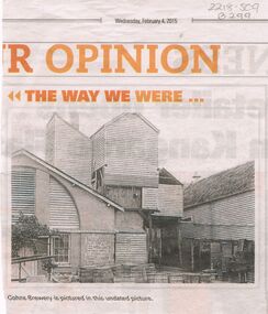 Bendigo Historical Society Inc.
Newspaper - COHN BROTHERS COLLECTION: COHNS BREWERY PHOTO ( COPY)
Three Cohn brothers, Jacob, Julius and Moritz came to Bendigo from Denmark in 1852. They were followed by their brother Solomon (Henry) in 1858. Jacob (1830-1911) married Rosa Levy in 1858 during a return trip to Denmark. Moritz (1822-1878) married Roschen Ballin in Germany in 1861. Julius (1828-1877) married Rosetta Spyer in Victoria in 1866. Henry (1826-1874) was married to Leah Fonseca.. Jacob, Moritz and Julius began the Victoria Brewery in Bridge Street in 1858, whilst Henry was described as a traveller and collector for Cohn Bros. in 1859. The brothers soon expanded into the making of cordials (soft drinks). In 1866 Henry took up a hotel in Sandridge (Port Melbourne). Moritz moved to Talbot and set up his own brewery before returning to Bendigo after Julius' death.Newspaper copy of photo of Cohns Brewery, undated picture, presented in the Bendigo Advertiser, Wednesday February 4, 2015, in 'The Way We Were'. Image shows timber, brick and stone insert on front (back?) of building. Wooden barrels in front of building, galvanised iron partitioned bins, along side of LH building. Appears to be the back of the building.bendigo, industry, cohn bros brewery -
 Eltham District Historical Society Inc
Photograph, Russell Yeoman, Fitzsimons Lane Bridge over Yarra River between Eltham and Templestowe, c.1970, 1970c
The bridge over the Yarra River was initially opened September 22nd, 1961. Newspaper reports at the time of opening stated it linked Bolton Street, Eltham, with Fitzsimons Lane, Templestowe. In 1955 the Country Roads Board (CRB) produced survey plans that showed proposed land acquisition for the future bridge and road approaches. The 1955 plan shows that it was proposed to connect Fitzsimons Lane with Bolton Street in Eltham by a diagonal road across the river. The road connection would then continue along Bolton Street to Main Road. Prior to construction of the bridge the CRB modified the proposal significantly so that there was a new road parallel with Bolton Street and then curving to join Main Road at what was then its intersection with Old Eltham Road. This involved significantly more land acquisition and altered the pattern of land subdivision through this corridor. Initially the new road was just a single two-way carriageway as it would have required a significant widening of the cutting on the Shire of Eltham side of the river. The road was officially un-named but was known locally as the Eltham-Templestowe Road. The 1966 Melway street directory and other 1960s editions also listed the road as the Eltham-Templestowe Road. In December 1970, Eltham Shire Council, in pursuance of the provisions of the Local Government Act, named it Templestowe Road. The road was renamed Fitzsimons Lane around 1984 in conformity with the section south of the river. In 1991 a new bridge was built to the west of the original bridge. Fitzsimons Lane was widened to four traffic lanes although on the Eltham side this was done within the limits of the existing cutting. NEW BRIDGE STARTS THEM EXPLORING Without any fanfares, Country Roads Board workmen on Friday afternoon put the finishing touches to the approaches, removed the barricades, and let the traffic roll over the new Yarra bridge linking Bolton Street, Eltham, with Fitzsimons Lane, Templestowe. Over the week-end many “bridge watchers” who were making one of their periodic inspections of the progress on the new bridge found to their surprise that they could drive over it, so that people who had gone for a run out to Eltham suddenly found themselves wandering through Templestowe and Doncaster. By Monday the word of the bridge’s opening had got around sufficiently for many regular travellers to the city from Eltham and beyond to vary the monotony by going to town via Templestowe and Kew instead of through Heidelberg. They were surprised at the distances – about 3 ½ miles from Eltham to Templestowe, 6 miles from Eltham Shire hall to the Lower Heidelberg Road-Banksia Street intersection. NEW NEIGHBOURS For people on both sides of the river, the new bridge has turned distant friends into near neighbours. A Greensborough man on Sunday took 35 minutes to reach the home of a friend in East Doncaster, but the return trip over the new bridge took only 17 minutes. It will be some time yet before most people work out the possibilities in shorter and quicker trips form the north-eastern areas to the eastern and south-eastern suburbs. The coming of the warmer months will soon teach many, though the short cuts to Peninsular beaches and eastern suburban drive-ins. And before very long it is likely there will be a Tramways bus running from Templestowe to Eltham station. NEW BRIDGE STARTS THEM EXPLORING (1961, September 27). The Diamond Valley News (News clipping held in SEA_74-1_047) The previously un-named road between Main Road and Yarra River, Eltham South, east of Bolton Street was named Templestowe Road, December 15, 1970 NAMING OF STREETS AND ROADS. (1970, December 15). The Diamond Valley News (News clipping held in SEA_74-2_022)Roll of 35mm black and white negative film, 4 of 7 stripsIlford HP4bridge, bridges, fitzsimons lane bridge, infrastructure, shire of eltham infrastructure, yarra river