Showing 628 items
matching australian survey regiment
-
 Bendigo Military Museum
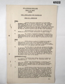
Administrative record - Royal Australian Survey Corps - 1st, 2nd and 3rd Order Triangulation Precis, School of Military Survey, Balcombe, Circa 1948 - 1960
A School of Military Survey Precis, 8 x foolscap sized pages of typed text, stapled and two hole punched. The precis No 3 covers the Observation procedure to be used for 1st, 2nd and 3rd Order Triangulation using the Royal Australian Survey Corps standard Cooke, Troughton and Simms Tavistock or Wild T2. The geodetic model Tavistock with a 5.25" horizontal circle should be used for 1st Order Triangulation and maybe used for 2nd Order Triangulation if specially directed. The standard Tavistock with 3.5" horizontal circle or the Wild T2 should be used for 2nd and 3rd Order observations. The Precis discusses the types of errors, the source of errors and the best ways of managing them. In surveying, triangulation is the process of determining the location of a point by measuring only angles to it from known points at either end of a fixed baseline by using trigonometry, rather than measuring distances to the point directly as in trilateration.A School of Military Survey Precis, 8 x foolscap sized pages of typed text, stapled and two hole punched.royal australian survey corps, rasvy, fortuna, army survey regiment, army svy regt, asr, school of military survey, sms, balcombe -
 Bendigo Military Museum
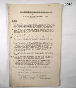
Administrative record - Application of Light Aircraft to Royal Australian Survey Corps Survey Operations - MAJ LB Sprenger (RASvy) 1957, Major LB Sprenger (RASvy), November 1957
Application of Light Aircraft to Royal Australian Survey Corps Survey Operations - MAJ LB Sprenger (RASvy) 1957. This is a report to determine if light aircraft was suitable and financially beneficial for use in Royal Australian Survey Corps Survey Operations. The results were so successful that funds were made available to RASvy for operation of light aircraft for survey purposes in the financial year 1958/59. For a number of years the US and Canadian Armies had made significant use of helicopters for survey purposes, this is the Australian experience. RASvy extensively used light aircraft for survey operations following this experience. MAJ LB Sprenger was later promoted and as LtCol LB Sprenger MBE he was the Commanding Officer of the Army Survey Regiment, Bendigo in 1969/70 and passed away during that appointment.A 23 x Foolscap page report of typed text, held together by staples and an ARNOS fastenerroyal australian survey corps, rasvy, fortuna, army survey regiment, army svy regt, asr -
 Bendigo Military Museum
Administrative record - Report on Mechanism Ltd Precision Aneroid Barometer Type M1847 - WO2 Lambert (RASvy) August 1960, WO2 Lambert RASvy, August 1960
This is a Report on the Mechanism Ltd Precision Aneroid Barometer Type M1847 by WO2 Lambert (RASvy) August 1960 under the direction of the Chief Instructor at the School of Military Survey Balcombe Victoria was to determine the accuracy of the instrument for calculating heights for mapping purposes.A 6 x Foolscap sized page report that is stapled and four hole punched.. The report contains typed text, diagrams and tabular results on the fold out annex.Number "54" in top RH cornerroyal australian survey corps, rasvy, fortuna, army survey regiment, army svy regt, asr, school of military survey, balcombe -
 Bendigo Military Museum
Administrative record - Australian Survey Corps - Survey Marks and Beacons Precis, School of Military Survey, Balcombe, Circa 1940, prior to 1948
This Australian Survey Corps School of Military Survey, Balcombe Precis has 5 x foolscap sized paper pages of typed text, stapled and is two hole punched. It was written to document the requirements for physically establishing a Permanent Australian Survey Corps Survey Ground Mark or Beacon. The Precis also discusses the different types of ground mark constructions.5 x foolscap sized paper pages of typed text, stapled and two hole punched. Paper is dis-coloured due to age.Hand written No "63" top RH cornerroyal australian survey corps, rasvy, fortuna, army survey regiment, army svy regt, asr, school of military survey, sms, balcombe -
 Bendigo Military Museum
Administrative record - Royal Australian Survey Corps - Planning for Field Survey Operations for 1:250,000 - LtCol JK Herridge (RASvy) 1960, LtCol JB Herridge (RASvy), April 1960
This 13 x page document contains notes on planning for RASvy Field Survey Operations in Northern Command during 1958 and 1959 with helicopter support available for field operations for 1:250,000 mapping. The Document was written by LtCol JB Herridge (RASvy) at the School of Military Survey Balcombe April 1960.13 x foolscap pages of typed text, stapled and four holed punchedHand written "53" in top RH cornerroyal australian survey corps, rasvy, fortuna, army survey regiment, army svy regt, asr, school of military survey, sms -
 Bendigo Military Museum
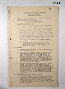
Administrative record - Royal Australian Survey Corps Planning Conference 1972 - Standard of Compilation sheets by LtCol DR Ridge (RASvy), LtCol DR Ridge (RASvy), Fortuna Bendigo, Circa 1972
This is a paper that was prepared for and delivered at the Royal Australian Survey Corps Planning Conference 1972 held at Fortuna Bendigo. The paper was written and delivered by LtCol DR Ridge RASvy.A 6 x A4 page report with typed text, stapled and four hole punchedroyal australian survey corps, rasvy, fortuna, army survey regiment, army svy regt, asr -
 Bendigo Military Museum
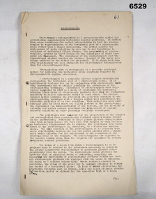
Document - Royal Australian Survey Corps - School of Military Survey Precis - Corrections to 1st Order Astronomical Observations 1964, School of Military Survey, Balcombe, 1964
This is a precis produced by the Royal Australian Survey Corps School of Military Survey in 1964. This is a very technical precis that describes the corrections that need to be applied to First Order Astronomical Theodolite Observations. First Order Astronomical positioning is the highest order and the most accurate determination of position using the stars and for that reason small allowances and corrections are needed to maintain/ improve relative accuracy.A 26 x page foolscap sized paper Precis, stapled and two hole punched. The precis does not have a protective cover and pages are discoloured. The precis contains typed text, tables and diagrams.royal australian survey corps, rasvy, fortuna, army survey regiment, army svy regt, asr, astronomy -
 Bendigo Military Museum
Document - Australian School of Military Survey - Stereotemplets Precis, School of Military Survey, Balcombe, Unknown
A 6 x page foolscap sized precis, two hole punched and stapled produced by the Australian School of Military Survey discusses using Stereo templet triangulation of aerial photography to establish extra supplementary horizontal control positions. Triangulation using Stereo Templates is a method of achieving the horizontal scale solutions required for photogrammetric mapping procedures.A 6 x page foolscap sized precis, two hole punched and stapled. The precis does not have a protective coverNo "61" on the top LH Cornerroyal australian survey corps, rasvy, fortuna, army survey regiment, army svy regt, asr, sms -
 Bendigo Military Museum
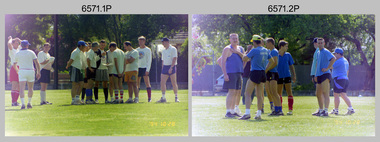
Photograph - 4th Field Survey Squadron Soccer Match. Adelaide, SA, 1994
This is a selection of 30 photographs of 4th Field Survey Squadron personnel participating in a soccer game, between the Other Ranks (ORs) and Officers/Warrant Officers/Senior Non-Commissioned Officers (OFFR/SNCOs), at an unknown location in Adelaide, South Australia on the 28th of October 1994.This is a selection of 30 photographs of 4th Field Survey Squadron personnel participating in a soccer game at an unknown location in Adelaide, South Australia on the 28th of October 1994. The colour photographs are part of a set of 72 photographs on 35mm negative film and are part of the Army Survey Regiment’s Collection. The photographs were scanned at 96 dpi. .1) - Photo, colour, 1994. OFFR/SNCOs L to R: SSGT A. Simcock. WO2 Peter Hammer, SGT Peter Hardy, unidentified, SSGT Brian Collings, unidentified, WO2 Simon ‘Andy’ Capp, SGT H. Evertz, OC MAJ Peter Demaine, unidentified, CAPT Chris Topovsek. .2) - Photo, colour, 1994. ORs L to R: unidentified (x3), CPL Steve Wegener, CPL Dick Crawford, unidentified, LCPL Mitch Oake, unidentified. .3) - Photo, colour, 1994. L to R: CAPT Chris Topovsek, SGT Steve McGuiness, LCPL Mitch Oake, WO2 Simon ‘Andy’ Capp, unidentified. .4) - Photo, colour, 1994. L to R: unidentified, CPL Steve Wegener. .5) - Photo, colour, 1994. L to R: WO2 Simon ‘Andy’ Capp, SSGT Pat ‘Fuji’ Drover, unidentified. .6) - Photo, colour, 1994. L to R: unidentified (x2). .7) - Photo, colour, 1994. L to R: SSGT A. Simcock, SPR Mark Linwood, SPR Mark McInerney, unidentified, CPL Dick Crawford. .8) - Photo, colour, 1994. CPL Dick Crawford. .9) - Photo, colour, 1994. L to R: unidentified, SGT Steve McGuiness, SPR Mark Linwood, SPR Mark McInerney, SSGT A. Simcock. .10) - Photo, colour, 1994. CPL Dick Crawford taking an indirect penalty. The wall L to R: SGT H. Evertz, WO2 Simon ‘Andy’ Capp, SSGT Pat ‘Fuji’ Drover, SGT Dave Longbottom. .11) - Photo, colour, 1994. OFFR/SNCOs half time L to R: OC MAJ Peter Demaine, unidentified, SGT Dave Longbottom, SSGT A. Simcock, unidentified, SGT Steve McGuiness, unidentified, WO2 Peter Hammer. .12) - Photo, colour, 1994. ORs half time L to R: unidentified, SPR Mark Linwood, CPL Peter Ball, CPL Steve Wegener, unidentified. .13) - Photo, colour, 1994. L to R: unidentified (x2), SPR Fran Calvert. .14) - Photo, colour, 1994. L to R: Unidentified, SPR Fran Calvert. .15) - Photo, colour, 1994. L to R: CPL Phuc ‘Charlie’ Tran, SPR Fran Calvert. .16) - Photo, colour, 1994. L to R: unidentified, SPR Mark Linwood, CPL Peter Ball. .17) & .18) - Photo, colour, 1994. Attempted goal. .19) - Photo, colour, 1994. L to R: unidentified, (x2), CPL Peter Ball, LT Andrew Caudle, SGT Steve McGuiness, CPL Dick Crawford, SSGT Pat ‘Fuji’ Drover. .20) - Photo, colour, 1994. SPR Fran Calvert tackled from behind. .21) - Photo, colour, 1994. Attempted goal. L to R: CPL Phuc ‘Charlie’ Tran, SPR Fran Calvert, remainder unidentified. .22) - Photo, colour, 1994. Goal celebration. L to R: CPL Phuc ‘Charlie’ Tran, SPR Fran Calvert, remainder unidentified. .23) - Photo, colour, 1994. Attempted goal. L to R: SGT Steve McGuiness, CPL Phuc ‘Charlie’ Tran, CPL Peter Ball, SGT Dave Longbottom. .24) - Photo, colour, 1994. Attempted goal. Keeper CPL Steve Wegener under pressure. .25) - Photo, colour, 1994. Goal scored. L to R: CPL Dick Crawford, remainder unidentified. .26) - Photo, colour, 1994. Keeper clearance L to R: SGT Steve McGuiness, CPL Dick Crawford, SGT Dave Longbottom. .27) - Photo, colour, 1994. L to R: SGT Steve McGuiness, OC MAJ Peter Demaine, SGT H. Evertz, CPL Peter Ball, CPL Phuc ‘Charlie’ Tran (eyes not on the ball), SGT Dave Longbottom. .28) - Photo, colour, 1994. Keeper saves extreme pressure L to R: unidentified, (x2), Dick Crawford, SGT Dave Longbottom, CPL Steve Wegener, unidentified. In foreground: unidentified (x2). .29) - Photo, colour, 1994. Skilled footwork L to R: SSGT Brian Collings, SPR Fran Calvert, WO2 Simon ‘Andy’ Capp. In background: unidentified, SSGT Pat ‘Fuji’ Drover. .30) - Photo, colour, 1994. L to R: unidentified, CPL Dick Crawford, OC MAJ Peter Demaine, SGT Dave Longbottom..1P to .30P – There are no personnel identified. ‘1994 OCT SOCCER MATCH ORs v OFFR/SNCOs’ annotated on negatives sleeve.royal australian survey corps, rasvy, 4 fd svy sqn -
 Bendigo Military Museum
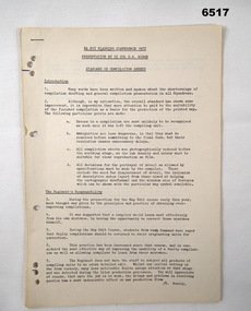
Administrative record - Trilateration with the Tellurometer - GRL Rimington 1958, Department of National Development , ACT, 26 May 1958
trilateration with the tellurometer by GRL Rimington L.S MIS (Aust) Chief Topographic Surveyor, Department of National Development, Australia. This paper was delivered to the Institute of Surveyors Conference, Brisbane 26 May 1958. This paper is a summary of Electronic distance measurements carried out in 1957 in Central Australia by officers of the division of National Mapping, Department of National Development. Trilateration is a surveying Technique that uses measurements of the sides of triangles to determine relative position.A 11 page foolscap size stapled paper report. Two holed punched with dis-coloured pages due to age.royal australian survey corps, rasvy, fortuna, army survey regiment, army svy regt, asr, division of national mapping, surveying -
 Bendigo Military Museum
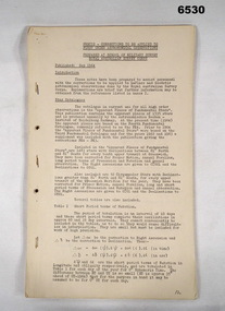
Administrative record - Royal Aust Svy Corps - Aust developments in the use of hovering helicopters to establish survey control - MAJ W Childs circa 1960, Major W Childs (RASvy), Circa 1960
An RASvy document about the development and trials in the use of hovering helicopters to establish survey control. Written by MAJ W Childs (RASvy) in circa 1960. Survey Control is points of known accurate position. 10 x A4 page report, hole punched and stapled. Booklet of typed text and diagramsroyal australian survey corps, rasvy, fortuna, army survey regiment, army svy regt, asr -
 Bendigo Military Museum
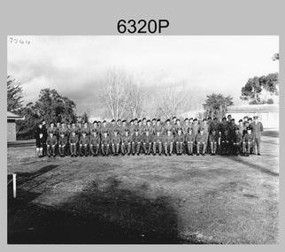
Photograph - Army Survey Regiment Warrant Officers and Sergeants, Fortuna, Bendigo, c1973
This photograph of the Army Survey Regiment’s Warrant Officers and Sergeants was taken on the parade ground at Fortuna Villa, Bendigo in c1973. WO1 John Hogan served as RSM of the Regiment from 1968 to 1976.This is a photograph of Warrant Officers and Sergeants posted to the Army Survey Regiment Fortuna Villa, Bendigo Victoria, c1973. The photograph was printed on photographic paper and is part of the Army Survey Regiment’s Collection. The photograph was scanned at 600 dpi. .1) - Photo, black & white c1973. Back Row L to R: Irene Saunders, Bob Hayden, Lloyd Patterson, Chris Sharp, Sgts Mess Spvr, Lloyd Harvey, John Waight, Ivor Hastings, Ace Evans, Andy Covington, Gordon Haswell, Jim Jefferies, Mick Dempster, Bill Forrest, Max Neil, Ted Burgess, Chris Kelly, Graeme Beasley, Peter Mansell, Dave Miles, unidentified, Geoff Wasser, Errol Fletcher, Doug Malligan, Len Thirlwell, Michael Wagland, Ian Bootland, Peter Dew, Jeff Lynch, John Rankine, George Austen, Jim Mitchell, Ken Slater, Alan Carew, Chris Wardley, Jim Mulqueen, Evan Giri. Front Row L to R: Marjorie Knight, Tom Pattison, Don Taylor, Bob McKenna, Bob Coultard, Stan Vote, Brian Rogers, Aub Harvey, RSM John Hogan, Neil Rankin, Clive Andrews, Tony Ellis, Alex Munro, Roger Rix, Joe Farrington, Tibby Szentirmay BEM, Fred Panknin, Ken Rich, Jack Williams, Ian Batt UK Exchange.There are no personnel annotated. ‘7744’ annotated on top left corner of photo.royal australian survey corps, rasvy, army survey regiment, army svy regt, fortuna, asr -
 Bendigo Military Museum
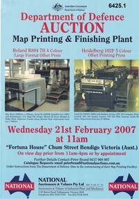
Flyer - Department of Defence Auction Flyer- Map Printing and Finishing Plant 21 Feb 2007, Department of Defence Auction Flyer - Map Printing and Finishing Plant 21 Feb 2007, 21 Feb 2007
This Flyer was produced by the Australian Govt Department of Defence for an auction to be held at Fortuna Bendigo on Wed 21 February 2007 at 11am for the sale of Map Printing and finishing Equipment that had been used by the Royal Australian Survey Corps at the Army Survey Regiment. The Flyer lists 76 x items of equipment being Auctioned. Items Auctioned include: Amrap Pallet Stretch Wrapping Machine, Crown 20IMT90 Electric Lift Truck, Roland R804 7B Large Format 4 x Colour Offset Printing Press, Wohlenburg 1850mm programmable Paper Guillotine Model MCS-2, Bauman Stack Lift, Barco Graphics Mega Setta Plus Large Format Image Setter, HP Design Jet 300P Colour Plotter and Heidelburg Speedmaster Model 102F 5 x Colour Offset Printing Press.A4 Auction Flyer, Blue, Double sided and 7 x photos of lithographic equipment. Contains lists of items to be auctioned.royal australian survey corps, rasvy, fortuna, army survey regiment, army svy regt, asr -
 Bendigo Military Museum
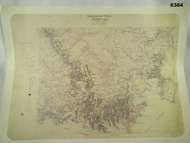
Map - Australian Topographical Survey SYDNEY / 56III Southern Half, NE Plane Table Field sheet 1915, Australian Survey Corps, 6 Dec 1915
... and was printed at the Army Survey Regiment, Bendigo. Royal Australian ...This is a unique example of a hand drawn plane table sheet produced in the first year of the Australian Survey Corps by original members of the Corps. Roseblade and Lynch 5 Dec 1915. Of interest is the documented times that it took to create the original field sheet. Also of interest is the fact that this field sheet that was used to create the actual SYDNEY map sheet was contoured, many map sheets produced up until now were purely planimetric and lacked contouring that was needed for military use. This is a reproduction print of a photograph of the original field sheet and was printed at the Army Survey Regiment, Bendigo.Reprinted coloured Image of Australian Topographical Survey SYDNEY /56 III Southern Half, hand drawn NE Plane Table field sheet. Includes an itemized summary of work performed by HA Roseblade CSM Australian Survey Corps 1915, Signed by J Lynch Lieutenant.royal australian survey corps, rasvy, fortuna, army survey regiment, army svy regt, asr -
 Bendigo Military Museum
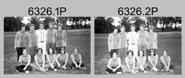
Photograph - Flag Day – Softball, Army Survey Regiment Verses School of Military Survey, Bendigo, 1977
These 25 photographs of softball team and sports action were taken on Flag Day, an annual sports competition between the Army Survey Regiment (ASR) and the School of Military Survey (SMS), at Bendigo on the 13th of May 1977. This event was held at Beischer Park, Strathdale. The two RA Svy units took turns each year to host the event. The day competition usually comprised basketball, cross country, golf, sailing, squash softball, tennis, rifle shooting, touch football, tug-of-war and volleyball. The evening competition often included darts, carpet bowls, hookey, quoits and snooker. See item 6325.15P for photos of golf, sailing, rifle shooting and squash teams and sports action taken on the day. This is a set of 25 photographs of softball team and sports action was taken on Flag Day, Army Survey Regiment (ASR) versus the School of Military Survey (SMS), at Bendigo on the 13th of May 1977. The photographs were printed on photographic paper and are part of the Army Survey Regiment’s Collection. The 35mm positive photographic proofs were scanned at 600 dpi. .1) & 2) - Photo, black & white, 1977, ASR Softball Team - L to R: Tracy (Beckwith) Phillips, unidentified, Gary Ames, Zoe (Lisiewich) Ames, Verity Dixon. Front row L to R: Sue (Nilon) Marner, Chris (Modrow) Stewart, unidentified, Di Chalmers, Lorraine ‘Snoopy’ (Daly) Talbot-Smith. .3) - Photo, black & white, 1977, SMS Softball Team: unidentified participants. .4) & 5) - Photo, black & white, 1977, Softball action: unidentified participants. .6) - Photo, black & white, 1977, Softball action L to R: unidentified (x2), Zoe (Lisiewich) Ames, Chris (Modrow) Stewart, unidentified (x3), Tracy (Beckwith) Phillips. .7) - Photo, black & white, 1977, Softball action L to R: unidentified, Di Chalmers. .8) - Photo, black & white, 1977, Softball action background L to R: unidentified, Ian Belmont, CO LTCOL Bob Skitch, Chris Carter. .9) - Photo, black & white, 1977, Softball action, Chris (Modrow) Stewart. .10) to 12) - Photo, black & white, 1977, Softball action: unidentified participants. .13) - Photo, black & white, 1977, Softball action: L to R: unidentified (x3), Lorraine ‘Snoopy’ (Daly) Talbot-Smith. .14) - Photo, black & white, 1977, Softball action: unidentified participants. .15) - Photo, black & white, 1977, Softball action: L to R: unidentified (x2), Lorraine ‘Snoopy’ (Daly) Talbot-Smith. .16) - Photo, black & white, 1977, Softball action: L to R: Sue (Nilon) Marner, unidentified, Lorraine ‘Snoopy’ (Daly) Talbot-Smith, unidentified. .17) - Photo, black & white, 1977, Softball action: unidentified participants, spectators L to R: unidentified, Peter Dew, Trevor Pearson, Alan Staley, Gavin Neilson, Ian Belmont, unidentified, Chris Carter. .18) - Photo, black & white, 1977, Softball action: unidentified participants and spectators. .19) & .20) - Photo, black & white, 1977, Softball action: unidentified participants, catcher Lorraine ‘Snoopy’ (Daly) Talbot-Smith. .21) - Photo, black & white, 1977, Softball action L to R: unidentified (x2), Chris (Modrow) Stewart, Tracy (Beckwith) Phillips, Lorraine ‘Snoopy’ (Daly) Talbot-Smith. .22) - Photo, black & white, 1977, Softball action: unidentified participants. .23) - Photo, black & white, 1977, Softball action L to R: Frank Lenane, Di Chalmers, Lorraine ‘Snoopy’ (Daly) Talbot-Smith, Zoe (Lisiewich) Ames, unidentified (x2). .24) & .25) - Photo, black & white, 1977, Softball action: unidentified participants..1P to .25P –No personnel are identified.royal australian survey corps, rasvy, army survey regiment, army svy regt, school of military survey, fortuna, asr, flag day -
 Bendigo Military Museum
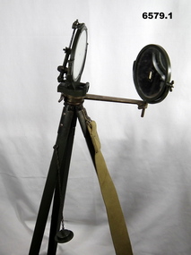
Instrument - Duplex Heliograph Mk V - 1940 with Tripod, LUCO Art Metal Coy Ltd, London, 1940
The Heliograph MkV is a fascinating piece of historical surveying and communications equipment. It was primarily used for visual signaling by reflecting sunlight with a mirror to send coded messages over long distances. This method was primarily useful in remote areas where other forms of communication were not available. The MkV model, specifically, was widely used by the British Army and other military forces from around 1906 until the mid 1960s. It remained in use with the Australian Army Survey Corps until the mid 1980s. The device typically included a 5 - inch mirror and was often mounted on a tripod for stability. Initially the instrument was used to communicate between survey stations using Morse code to coordinate their activities. Later when better forms of communication were available, they were used for precise angle alignment where the sunlight reflection from the mirror was targeted between the survey stations to give very accurate results. The MkV was relatively light weight and portable, making it ideal for use in the field. It could be setup and adjusted quickly. The heliograph had an adjustable mirror that could be tilted to reflect sunlight towards a distant receiver. Surveyors could align the mirror using a sighting device. Whilst it was primarily used by the Military it was also used in civil surveying particularly in the remote areas of Australia. The British Army Mark V version uses a flat round mirror with a small unsilvered spot in the centre. The sender aligned the heliograph to the target by looking at the reflected target in the mirror and moving their head until the target was hidden by the unsilvered spot. Keeping their head still, they then adjusted the aiming rod so its cross wires bisected the target, they then turned up the sighting vane, which covered the cross wires with a diagram of a cross, and aligned the mirror with the tangent and elevation screws, so the small shadow that was a reflection of the unsilvered spot hole was on the cross target. This indicated that the sunbeam was pointing at the target. If the sun was in front of the sender, its rays were reflected directly from this mirror to the receiving station. If the sun was behind the sender, the sighting rod was replaced by a second mirror, to capture the sunlight and direct it onto the main mirror to reflect it to the receiving station.. 1 Brish Army "Mance" Mk V A253 Heliograph has two 125mm diameter mirrors on a brass arm with targeting attachments. The Instrument is mounted on a three-legged tripod of brass and mahogany with spiked feet, approximately 1.2 metres high. The instrument was made by LUCO Art Metal Co Ltd, London in 1940. .2 A military green metal carrying safety storage case with khaki shoulder strap.A253 stamped on instrumentroyal australian survey corps, rasvy, fortuna, army survey regiment, army svy regt, asr -
 Bendigo Military Museum
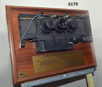
Plaque - Mounted Klimsch Commodore Cartographic Camera Lenses, WYCOMBE Constructions Pty Ltd, 1997
These are the Lenses from the Klimsch Commodore Cartographic Camera that was located in Lithographic Squadron at the Army Survey Regiment, Fortuna, Bendigo. The KLIMSCH Commodore camera was originally introduced to the Survey Regiment in 1953 and was the largest in the Southern Hemisphere. It was replaced with a new model of the same size in 1977. These lenses are from this new model. The new model with its computer-based interface provided productivity gains with improved speed and its consistent results led to less wastage in time and materials. Its variomat lens system provided improved retention of map feature linear weights during the camera reduction process. The camera which was specially made for the Australian Army in Germany was fully automatic and power operated. It was claimed to be one of the biggest automatic cameras of its type in the world. It was made to the specifications of the Royal Australian Army Survey Corps to assist in the production of the very high standard maps for the Australian Army. THIS KLIMSCH COMMODORE CARTOGRAPHIC CAMERA was in operation 1977 - 1997". It was a Precision Darkroom Camera especially suited for Cartographic Reproduction of Line, Continous Tone, Halftone and Colour Separation. Reproduction of Negatives and Positives from a variety of Reflection or Transmission Originals. Its characteristics were: Maximum Negative Size 1.27m sq, Copy Holder (Vacuum) 2m sq, Maximum Enlargement 400%, Maximum Reduction 13%, Automatic 60, 90 and 120cm Focal Length Lens, Transmission or Reflection Originals, Pulsed Xenon, Photo Flood or Fluorescent Tube Light Source, Maximum Reflection Original 1.3m x 1.85m, Maximum Transmission Original 1.3m x 1.85m, Exposure Light Monitoring System." The camera was superseded by computerized image manipulation software associated with the Automap system. These significant and extremely high-quality Lenses were retrieved by WYCOMBE Constructions Pty Ltd during the demolishment of the camera in 1997 and then mounted on a display board. See also Item 6189.4P for more photographs of the camera.Lenses from the Klimsch Commodore Cartographic Camera mounted on a very heavy timber display board. The display board contains an engraved plate that describes the technical characteristics of the camera."KLIMSCH COMMODORE CARTOGRAPHIC CAMERA 1977 - 1997", "FUNCTION: Precision Darkroom Camera especially suited for Cartographic Reproduction of Line, Continous Tone, Halftone and Colour Separation. Reproduction of Negatives and Positives from a variety of Reflection or Transmission Originals." "CHARACTERISTICS: Maximum Neg Size 1.27m sq, Copy Holder 2m sq, Maximum Enlargement 400%, Maximum Reduction 13%, Automatic 60, 90, 120cm Focal Length Lens, Transmission or Reflection Originals, Pulsed Xenon, Photo Flood or Fluorescent Tube Light Source, Maximum Reflection Original 1.3m x 1.85m, Maximum Transmission Original 1.3m x 1.85m, Exposure Light Monitoring System." royal australian survey corps, rasvy, fortuna, army survey regiment, army svy regt, asr, litho -
 Bendigo Military Museum
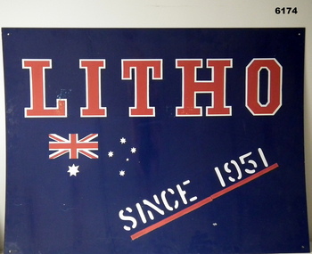
Sign - Litho Squadron, Army Survey Regiment metal sign, Signwriter for Lithographic Squadron, circa 1970's
This large metal sign was affixed to the wall outside the entrance to the Lithographic Squadron at the Army Survey Regiment at Fortuna VillaA large metal sheet sign , painted dark blue with text "LITHO" in red, outlined in white. Text "SINCE 1951" painted in white underlined in red. An Australian flag in red and white is incorporated in the design."LITHO SINCE 1951"royal australian survey corps, rasvy, fortuna, army survey regiment, army svy regt, asr -
 Bendigo Military Museum
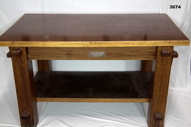
Furniture - TABLE, POW, c.1943 - 1944
... . Army Survey Regiment Royal Australian Survey Corps RASvy Army ...This table was made by Italian POW's at the Land HQ Cartographic Company for the Officers Mess, Fortuna, Bendigo in 1943-44.Coffee table made from timber & masonite, has bottom shelf, all sections held together by wedge & groove, timber section has been varnished.Plaque etched & attached to table: This Table Was Hand Made By The Italian Prisoners Of War Attached To The Land Headquarters Cartographic Company For The Officers Mess 1943 - 1944army survey regiment, royal australian survey corps, rasvy, army svy regt, fortuna, asr -
 Bendigo Military Museum
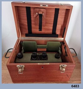
Instrument - Old Delft Scanning Stereoscope ODSS III, C. 1956
... at the Army Survey Regiment, Bendigo. Royal Australian Survey Corps ...This is a superbly crafted cartographic mapping instrument. It is housed in its own high-quality purpose-built oak box. Made in the Netherlands from 1950 onwards. This instrument is from c 1956. it is a very high-quality military grade stereoscope that was generally used by photographic interpreters such as intelligence analysts but was equally useful for mapping activities. The stereoscope was used to examine 3D aerial photographic images. This instrument has a particularly useful capability to scan over the 3D stereo model using X and Y movement knobs, rather than having to physically move the aerial photographs. In the public and private sector it was also useful for photogrammetric interpretation for Forestry and Agricultural purposes. See also Bendigo RSL Collections Victoria item Number 6205.6P that shows the Old Deft Stereoscope in use at the Army Survey Regiment, Bendigo.This is an "Old Delft" scanning stereoscope with its reflecting carriage and legs. The Stereoscope is housed in its own purpose built wooden oak box that has dovetail joints, 2 x securing clips, 2 x handles and a lock (without key). The instrument is assembled by inserting colour coded legs into their matching slots."OLD DELFT SCANNING STEREOSCOPE ODSS III" "Patents Applied for" "OLD DELFT C4790" "MADE IN THE NETHERLANDS"royal australian survey corps, rasvy, fortuna, army survey regiment, army svy regt, asr -
 Bendigo Military Museum
Instrument - Universal Stereoscope, 1940
The Universal Stereoscope was used to view overlapping stereo aerial photography in three dimensions (3D). It consists of magnifying lenses, an optical train including glass prisms and mirrors that are protected by sliding metal covers all suspended on a pair of fold out adjustable legs. The stereoscope is coloured military olive drab green. This Universal Stereoscope was produced in Australia in 1940 for Military use. It was originally produced with a timber protecting carry box that is missing. It was used extensively by members of the Australian Survey Corps during WWII in many theatres of War for viewing and annotating aerial photography. Item 6205.6P, photograph 6205.1P shows the Universal Stereoscope in use by the Australian Survey Corps annotating aerial photography.The Universal Stereoscope was used to view overlapping stereo aerial photography in three dimensions (3D). It consists of magnifying lenses, an optical train including glass prisms and mirrors that are protected by sliding metal covers all suspended on a pair of fold out adjustable legs. The stereoscope is coloured military olive drab green."DC-1940 Serial No 550", "D V D", "Made in Australia" Plate on the underside reads " This stereoscope was donated to the Ex Fortuna Survey Association by the Eaglehawk Recycle Shop February 2015"royal australian survey corps, rasvy, fortuna, army survey regiment, army svy regt, asr -
 Bendigo Military Museum
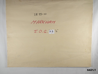
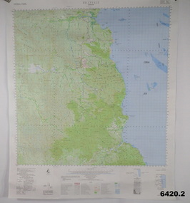
Map - SB55-10 Markham Joint Operations Graphics Air and Ground print separations, Royal Australian Survey Corps, Bendigo, Dec 1981
This set of map prints was assembled as a training aid. The collection is a complete set of individual color prints of each colour used on the final printed maps for each map Joint Operations Graphic (JOG) JOG Ground and JOG Air versions. This map series was produced in two versions to help coordinate military Ground Operations and Air Operations. The ground users required that heights and measurements were in Metres, whilst air users required height information in Feet for altimeters. The Air Version also contained more Aeronautical information including safe flying height information called Maximum Elevation Figures (MEF). Later printing of JOG incorporated printing in just four colours Cyan, Magenta, Yellow and Black (CMYK). Item 6421.1 is an example of a JOG Ground and item 6421.2 is an example of its matching JOG Air version.1:250,000 SB55-10 Markham JOG A and G colour separations bound together in a manilla card covered folder bound with a timber edge. royal australian survey corps, rasvy, fortuna, army survey regiment, army svy regt, asr -
 Bendigo Military Museum
Poster - Map Production flow chart poster using Automap 2, Army Survey Regiment, Bendigo, 1982
This poster designed to be folded into a brochure describes the second phase of the computer assisted cartographic system to be used by the Royal Australian Survey Corps in the establishment of a topographic data base, Future tactical applications and map products using the data base are displayed. A topographic map of Series R631 1:100,000 Helenvale, Queensland printed on the reverse side that was produced by the Automap system using information from the topographic data base. This is the fifth edition of the poster.A multi colour poster of map production using the Automap 2 system. Poster shows a schematic and pictorial flow chart diagram of the stages of the map production process using the Automap 2 system. The poster was intended to be folded into a small brochure. A 1:100,000 Army Survey Map Series R631, 7966 Helenvale, Queensland Edition 2 is printed on the reverse side of the poster. The map is an example of one of the initial maps produced on the Automap 2 System at the Army Survey Regiment, Bendigo.royal australian survey corps, rasvy, fortuna, army survey regiment, army svy regt, asr, automap 2 -
 Bendigo Military Museum
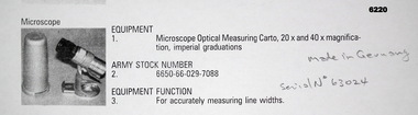
Instrument - Microscope Optical Measuring Cartographic, Hensoldt Wetzlar, Circa 1960
A very accurate microscope for measuring cartographic line-weights (thickness) during the Mapping process. Could be used to measure positive or negative line-weights or scribed lines in imperial measurements. Used at the Army Survey Regiment during the manual production of maps or charts.Silver alloy protecting Tube 5.5cms diameter and 12cms in height containing a Cartographic Microscope with imperial measurements. The Microscope is capable of 20 to 40 times magnification.Manufactured by "HENSOLDT WETZLAR" Serial Number 63024royal australian survey corps, rasvy, fortuna, army survey regiment, army svy regt, asr -
 Bendigo Military Museum
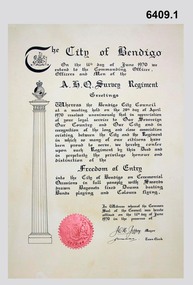
Certificate - Army Survey Regiment City of Bendigo Freedom of Entry Certificate 1970, Ian Wallace and AHQ Survey Regiment, Bendigo, June 1970
The certificate was issued by the City of Bendigo to AHQ Survey Regiment awarding the Regiment "Freedom of Entry" on ceremonial occasions. The certificate recognises the long service and close association between the Regiment and the City. Three certificates with seals were produced. One held by the City of Bendigo, one held by the Regiment and one was held by Ian Wallace who produced the certificates when he was part of the City's Engineering Department. The Freedom of Entry to the City was first conferred by the Bendigo City Council to the Army Survey Regiment in 1970. The unit then exercised its freedom by marching into the city with swords drawn, bayonets fixed and drums beating. The honour is usually bestowed upon local regiments, in recognition of their dedicated service, and it is common for military units to periodically exercise their freedom by arranging a parade through the city. The parade generally concluded after formal inspections of the troops. Regiment members were often treated to a civic reception at the City Hall after the ceremony. The Regiment also exercised its Freedom of Entry with anniversary parades in 1977, 1980, 1985, 1990 and 1995.The Regiment copy of the certificate was sent to the Army Military Museum at Holsworthy when the unit was disbanded and this copy (6409.1) held in the Bendigo RSL Museum is the copy that was originally held by the City of Bendigo. 6409.2 is a photograph of Gary Warnest, President ExFortuna Survey Association (left) holding the certificate 6409.1 and Mr Ian Wallace the certificate producer (right).Large framed certificate. Wooden frame, glass protecting the certificate.royal australian survey corps, rasvy, fortuna, army survey regiment, army svy regt, asr -
 Bendigo Military Museum
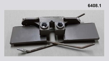
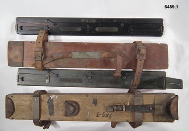
Instrument - Plane Table Surveying - Simple Alidade, ER Watts and Son, London, 1938
The Plane Table Alidade was used as the sighting Instrument in the production of historical manual hand drawn maps. A Plane Table Board mounted on a tripod is levelled and the Alidade is placed on the table with the vanes perpendicular to the it. Each sighting vane has a central thread lined up on the target and the angle to that target point is then drawn on the map sheet using the beveled fiducial edge. Plane Table Surveying is used as a quick method where less accuracy is required or needed. Plane table Surveying is a relatively portable and inexpensive method and was used extensively before the advent of sophisticated surveying instruments. The photo at 6489.2 is an Australian Army Survey Corps Party using a Plane Table Alidade in Syria during WWII. See also item 6580 which is the Plane Table with tripod legs that was used with the Alidade.Two Plane Table sighting instruments (Alidade) used for historical manual map making housed in wooden transit boxes. A brass instrument with folding sights at each end and a beveled fiducial edge in one edge. The front sight is the object vane and the rear sight is the sight vane. There is a sliding arm attached to the base to draw parallel lines to the fiducial edge. Very slight differences in model between these two instruments.First Instrument, "ER Watts and Son, London, 1938, MkII, Box Label 423. Second Instrument - R. E-Co, Mk.II, stamped E686, Box Label 686.royal australian survey corps, rasvy, fortuna, army survey regiment, army svy regt, asr -
 Bendigo Military Museum
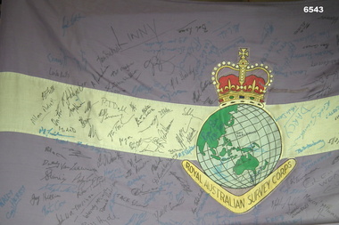
Flag - Royal Australian Survey Corps Flag - 4 Fd Svy Sqn Signed, Directorate of Military Survey, Canberra, Mid to late 1970's
Survey Corps Flags of this type were produced mid to late 1970's and distributed to all Survey Corps Units. This flag was issued to 4 Fd Svy Sqn and flew during daylight hours on the Unit flag pole at Keswick Barracks, Adelaide from issue until 1995. The flag was signed by about 160 of the 208 attendees at the Ceremonial closing of the Unit on 25 November 1995. A photograph of attendees at the Closing Ceremony is at item 6542.1P and the list of names at 6542.2P and they are stored in Box 278. The Survey Corps Flag that was issued to the Army Survey Regiment is at item 6177 and is stored in Box 218.A full size Corps Flag, purple with 18cm horizontal white stripe. Multi-coloured Survey Corps Badge (less scroll) in the centre of the flag. White header with grommets top and bottom. The Flag has about 160 signatures of past unit members. The Flag is badly faded and the end is fraying.royal australian survey corps, rasvy, fortuna, army survey regiment, army svy regt, asr, 4 fd svy sqn -
 Bendigo Military Museum
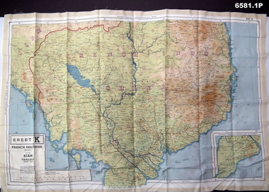
Photograph - Photograph of a silk map of Indo China, Circa 1939
Silk maps were produced as "Escape Maps" as they were easily folded and compressed to carry. They were often sewn into the jackets of aircraft pilots..1P Photograph of a Silk map of Indo China Map No 44K covering Siam (Thailand) and part of Vietnam and Cambodia at a scale of 1:1million. The map has contours (heights) and legend panel information. .2P Photograph of the reverse side of a Silk map of Indo China Map No 44J covering Siam (Thailand) at a scale of 1:1million. The map has contours (heights) and legend panel information. royal australian survey corps, rasvy, fortuna, army survey regiment, army svy regt -
 Bendigo Military Museum
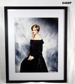
Photograph - HRH The Princess of Wales "Lady Diana" - Colonel in Chief of the Royal Australian Survey Corps, 1988
Her Majesty, Queen Elizabeth II approved the appointment of HRH The Princess of Wales "Lady Diana" as the Colonel in Chief of the Royal Australian Survey Corps (RASvy) on 1 July 1988. A copy of this image was presented to RASvy for official use.Framed photograph of HRH The Princess of Wales "Lady Diana" - Colonel in Chief of the Royal Australian Survey Corps in a black dress, white border and black frame.royal australian survey corps, rasvy, fortuna, army survey regiment, army svy regt, asr -
 Bendigo Military Museum
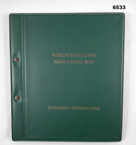
Manual - Royal Australian Survey Corps - Northern Command Field Survey Unit Technical Instructions 1966-73, Northern Command Field Survey Unit, Brisbane, Aug 1966 - Feb 1973
The Royal Australian Survey had Field Survey Units located in most States of Australia. Northern Command Field Survey Unit was located in Brisbane. This folder contains technical Instructions for tasks carried out by the Unit from Survey control and data capture through to Field completion. The folder is held together by Chicago screws so that Instructions could be updated when necessary. Instruction No1 Production Data Records Aug 1966 23x pages, Instruction No2 Standard Operating Procedure for B8 Stereoplotting Oct 1967 4 x pages, Instruction No3 Provisional Compilation Specifications 1:100 mapping contouring Oct 1967 (Missing), Instruction No4 Horizontal Control Station Summaries Aug 1972 13 x pages, Instruction No5 Airphotography Mar 1972 8 x pages, Instruction No6 Reconnaisance Station marking and Station Notes Aerodist Operations Mar 1972, 13 x pages, Instruction No7 Field Completion Feb 1973, 7 x pages.A hard green plastic covered manual of 68 x paper pages of typed text diagrams and tables, some fold out Annexes. The pages are held together with two Chicago screwsWhite # "5 " inside front and back coversroyal australian survey corps, rasvy, fortuna, army survey regiment, army svy regt, asr, norther command field survey unit