Showing 608 items
matching boundary road
-
 Merri-bek City Council
Print - Digital image, Marshall White, Strip 1, 1987
Marshall White is a former Merri-bek resident and artist. He completed a Fine Art diploma at the National Gallery Art School in 1973. After a severe motorcycle accident left him with quadriplegia in 1977, he returned to university, earning a Master in Painting from what is now the Victorian College of the Arts. White is considered a pioneer of digital art in Victoria. He taught art to inmates at Pentridge Prison, which provided him with access to early computers. Using a Commodore Amiga, Marshall pushed the boundaries of digital art. Strip 1 represents an early contribution to what was, at the time, an emergent art form. Inspired by William Blake and Arthur Boyd, White’s work delves into psychological spaces, addressing themes such as the apocalypse and White’s distain of religion. White's work exemplifies resilience and the transformative power of creativity in the face of challenges.Purchased -
 Merri-bek City Council
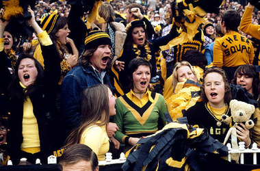
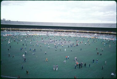
C-type print, Rennie Ellis, Richmond Fans, Grand Final, MCG 1974, 1974
Rennie Ellis (1940–2003) was as a pivotal figure in Australian visual culture. He was both a documentary photographer and a prominent presence in advertising, television and photography. Ellis was known for his candid documentary images of contemporary Australian life. His photographs of social events, such as music festivals, fashion parades or nightclubs are iconic, but his practice also encompassed the grittier side of life. In his AFL series, Ellis skilfully portrays the nation’s passion for the game, extending his lens beyond the boundary line to showcase the spirited fans alongside the on-field action. -
 Merri-bek City Council
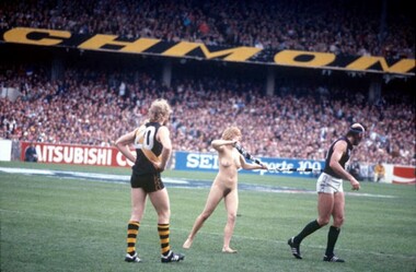
C-type print, Rennie Ellis, The Streaker, Grand Final, MCG 1982, 1982
Rennie Ellis (1940–2003) was as a pivotal figure in Australian visual culture. He was both a documentary photographer and a prominent presence in advertising, television and photography. Ellis was known for his candid documentary images of contemporary Australian life. His photographs of social events, such as music festivals, fashion parades or nightclubs are iconic, but his practice also encompassed the grittier side of life. In his AFL series, Ellis skilfully portrays the nation’s passion for the game, extending his lens beyond the boundary line to showcase the spirited fans alongside the on-field action. In Ellis' photo, a woman streaks at an AFL game – two players stand in frame with her, a Richmond and Collingwood player respectively. Behind them the crowd and a large Richmond banner can be seen. Playful and spirited interactions such as this are a key aspect of Australian football culture. -
 Merri-bek City Council
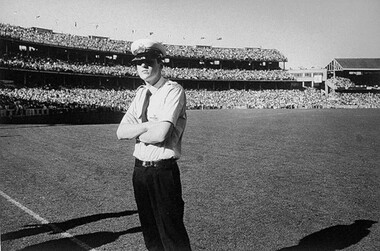
Giclee print, Rennie Ellis, Policeman, Jolimont 1973, 1973
Rennie Ellis (1940–2003) was as a pivotal figure in Australian visual culture. He was both a documentary photographer and a prominent presence in advertising, television and photography. Ellis was known for his candid documentary images of contemporary Australian life. His photographs of social events, such as music festivals, fashion parades or nightclubs are iconic, but his practice also encompassed the grittier side of life. In his AFL series, Ellis skilfully portrays the nation’s passion for the game, extending his lens beyond the boundary line to showcase the spirited fans alongside the on-field action. In Ellis' photo, a young police officer stands on the stadium ground with his arms sternly crossed, while the crowd waits for the game. This photo highlights the tension between passionate crowds and the police at AFL games. -
 Merri-bek City Council
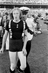
Giclee print, Rennie Ellis, Fan escorted by policeman, Jolimont 1974, 1974
Rennie Ellis (1940–2003) was as a pivotal figure in Australian visual culture. He was both a documentary photographer and a prominent presence in advertising, television and photography. Ellis was known for his candid documentary images of contemporary Australian life. His photographs of social events, such as music festivals, fashion parades or nightclubs are iconic, but his practice also encompassed the grittier side of life. In his AFL series, Ellis skilfully portrays the nation’s passion for the game, extending his lens beyond the boundary line to showcase the spirited fans alongside the on-field action. -
 Merri-bek City Council
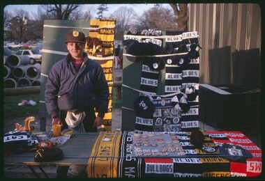
C-type print, Rennie Ellis, Man standing with table of football fans’ merchandise c.1986, c. 1986
Rennie Ellis (1940–2003) was as a pivotal figure in Australian visual culture. He was both a documentary photographer and a prominent presence in advertising, television and photography. Ellis was known for his candid documentary images of contemporary Australian life. His photographs of social events, such as music festivals, fashion parades or nightclubs are iconic, but his practice also encompassed the grittier side of life. In his AFL series, Ellis skilfully portrays the nation’s passion for the game, extending his lens beyond the boundary line to showcase the spirited fans alongside the on-field action.Donated by the Rennie Ellis Photographic Archive -
 Merri-bek City Council
C-type print, Rennie Ellis, Kids on MCG after VFL game 1980s, c. 1980
Rennie Ellis (1940–2003) was as a pivotal figure in Australian visual culture. He was both a documentary photographer and a prominent presence in advertising, television and photography. Ellis was known for his candid documentary images of contemporary Australian life. His photographs of social events, such as music festivals, fashion parades or nightclubs are iconic, but his practice also encompassed the grittier side of life. In his AFL series, Ellis skilfully portrays the nation’s passion for the game, extending his lens beyond the boundary line to showcase the spirited fans alongside the on-field action.Donated by the Rennie Ellis Photographic Archive -
 Merri-bek City Council
C-type print, Rennie Ellis, Richmond teddy mascot in a car 1982, 1982
Rennie Ellis (1940–2003) was as a pivotal figure in Australian visual culture. He was both a documentary photographer and a prominent presence in advertising, television and photography. Ellis was known for his candid documentary images of contemporary Australian life. His photographs of social events, such as music festivals, fashion parades or nightclubs are iconic, but his practice also encompassed the grittier side of life. In his AFL series, Ellis skilfully portrays the nation’s passion for the game, extending his lens beyond the boundary line to showcase the spirited fans alongside the on-field action.Donated by the Rennie Ellis Photographic Archive -
 Merri-bek City Council
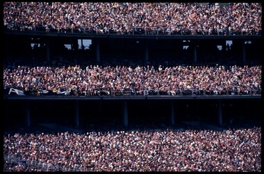
C-type print, Rennie Ellis, Three tiers of spectators in stands at game, 1972
Rennie Ellis (1940–2003) was as a pivotal figure in Australian visual culture. He was both a documentary photographer and a prominent presence in advertising, television and photography. Ellis was known for his candid documentary images of contemporary Australian life. His photographs of social events, such as music festivals, fashion parades or nightclubs are iconic, but his practice also encompassed the grittier side of life. In his AFL series, Ellis skilfully portrays the nation’s passion for the game, extending his lens beyond the boundary line to showcase the spirited fans alongside the on-field action.Donated by the Rennie Ellis Photographic Archive -
 Merri-bek City Council
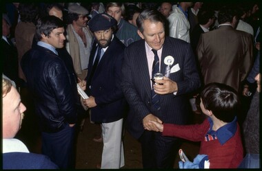
C-type print, Rennie Ellis, Malcolm Fraser, VFL Grand Final 1979, 1979
Rennie Ellis (1940–2003) was as a pivotal figure in Australian visual culture. He was both a documentary photographer and a prominent presence in advertising, television and photography. Ellis was known for his candid documentary images of contemporary Australian life. His photographs of social events, such as music festivals, fashion parades or nightclubs are iconic, but his practice also encompassed the grittier side of life. In his AFL series, Ellis skilfully portrays the nation’s passion for the game, extending his lens beyond the boundary line to showcase the spirited fans alongside the on-field action. In Ellis’ photograph Malcom Fraser, VFL Grand Final 1979 we see a young supporter shake hands with Liberal Prime Minister, Malcom Fraser. In the grand Australian tradition, politicians and PMs are active in the football sphere. This work was shown in the 2017 Counihan Gallery exhibition Leather Poisoning, along with many other works by Ellis capturing the nations love of the game. Donated by the Rennie Ellis Photographic Archive -
 Merri-bek City Council
C-type print, Rennie Ellis, Carlton Supporter, VFL Grand Final 1982, 1982
Rennie Ellis (1940–2003) was as a pivotal figure in Australian visual culture. He was both a documentary photographer and a prominent presence in advertising, television and photography. Ellis was known for his candid documentary images of contemporary Australian life. His photographs of social events, such as music festivals, fashion parades or nightclubs are iconic, but his practice also encompassed the grittier side of life. In his AFL series, Ellis skilfully portrays the nation’s passion for the game, extending his lens beyond the boundary line to showcase the spirited fans alongside the on-field action.Donated by the Rennie Ellis Photographic Archive -
 Merri-bek City Council
Work on paper - Aerosol painting, synthetic polymer, gouache and colour pencils on Magnani paper, Luke King, Portrait, 2023
Luke King’s mixed media artwork Portrait (2023) was shown in the group exhibition Fever’Dreams at the Counihan Gallery in 2023. The group exhibition explored the slippery boundaries between abstract and figurative artwork, showcasing local artists with a strong connection to Merri-bek’s arts community. King uses portraiture to highlight the importance of gesture and facial expression in personal storytelling. Exhibition curator of Fever’Dreams, Mitchel Brannan, writes of King’s work: ‘King explores the profound capacity of the human face to convey emotions within the context of constraint. Through his art, King invites viewers to reflect on the complexities of human expression and the underlying dynamics of restraint within society.’ -
 Eltham District Historical Society Inc
Photograph, C.S. Wingrove, Secretary, Eltham District Road Board 1858-1871; Shire Secretary, Shire of Eltham 1871-1904, 1858-1871
Charles Symons Wingrove, J.P. (1829-1905) arrived in Victorian in 1851. He had trained as an engineer, but tried his luck on the goldfields. In 1857 he was appointed as Secretary to the Eltham District Roads Board only one year after its foundation. He was to hold the position with the Board and later the Eltham Shire Council for total of 47 years. He also held the position of engineer for a large part of this period. During part of this time he was also secretary to the Heidelberg Shire Council. Over this period he was responsibly for an area stretching from Clifton Hill to Healesville, along the northern bank of the Yarra River. Other positions included Secretary to the Victorian Agricultural Society over along period.Wingrove was a main figure in the Municipal Association of Victoria. By the time he retired he was recognized as the “Grand Old Man” of Victorian local government. In 1858 Wingrove had a brick cottage built in Main Road near the State School and he lived here until his death. One room was uded as the Board and Council office. His descendants owned the house until 1974. It was later used as a psychiatric clinic. The park opposite the cottage has been named Wingrove Park in his honour. He is buried at St Helena with other members of his family. Age (Melbourne, Vic. : 1854 - 1954), Tuesday 18 July 1905, page 5 ABOUT PEOPLE. A conspicuous figure in northern municpal history, Mr. Charles Symons Wingrove, has passed away. He was for many years secretary and engineer for the shire of Eltham, and prior to the formation of the shire held the position under the old road board, his official connection with the district dating from beyond 1857. For about twelve years he also filled the position of shire engineer for Heidelberg council while retaining his other post, and the immense territory under his professional control, reaching from the boundary of Collingwood up to Healesville, was a matter of fatherly pride and interest to him. He arrived in Victoria in 1851, and was 76 years of age at his death. Mr. Wingrove retired from the position in the Eltham council only about a year ago. The interment will take place in St. Helena Cemetery, near Eltham township, today. Secretary, Eltham District Road Board 1858-1871 Secretary for the Shire of Eltham 1871-1904. Nearly 50 years service to the local community. For about twelve years he also filled the position of shire engineer for Heidelberg council. Reproduced Page 137 "Pioneers & Painters" This photo forms part of a collection of photographs gathered by the Shire of Eltham for their centenary project book,"Pioneers and Painters: 100 years of the Shire of Eltham" by Alan Marshall (1971). The collection of over 500 images is held in partnership between Eltham District Historical Society and Yarra Plenty Regional Library (Eltham Library) and is now formally known as the 'The Shire of Eltham Pioneers Photograph Collection.' It is significant in being the first community sourced collection representing the places and people of the Shire's first one hundred years.Digital image Print 25 x 20 cmc.s.wingrove, charles symons wingrove, eltham district road board, sepp, shire of eltham pioneers photograph collection, shire secretary, wingrove cottage, pioneers and painters, shire of eltham, councilor, municipal officer -
 Warrnambool and District Historical Society Inc.
Document - Warrnambool City Council Preliminary Report Industrial Estate West Warrnambool, E Johnson, 9 March 1973
This preliminary report relates to 32½ acres of council owned land in West Warrnambool bounded on the North by McMeekin Road, on the East by Scott Street, on the South by Evans Street and on the West by the rear boundaries of properties facing Landmann and Granter Streets. In 2010, West Warrnambool was the largest of Warrnambool’s existing industrial areas, comprising approximately 109ha of industrial zoned land, the majority of which (101ha) is zoned IN1Z, with the remainder zoned INZ3. The area comprises a mixture of lot sizes supporting a diverse mix of industries. Larger parcels are occupied by the abattoirs, scrap metal industries, freight, the Council Depot and storage. Smaller lots are occupied by smaller manufacturers and wholesalers and service industries. [Ref: Warrnambool Industrial Land Use Review. Mesh Pty Ltd July 2010]This document is a preliminary report prepared by the Warrnambool City Council Engineer in March 1973 and provides an example of the planning process undertaken to develop one of Warrnambool's industrial areas. It contains details and costings of the proposed subdivision. Two foolscaps size pages of typewritten information. A detailed topographical map of the area with areas highlighted in blue, red, green, blue and purple pen.warrnambool city council, west warrnambool, industrial estate -
 Eltham District Historical Society Inc
Photograph - Digital Photograph, Alan King, Nillumbik Shire Offices, Greensborough, 30 March 2008
Nillumbik Shire Council transferred to the former Diamond Valley Shire Offices in Greensborough after municipal restructuing. The offices became the official Nillumbik Shire Council Offices on 16 October 1995. The former Shire of Diamond Valley Civic Centre or Shire Office building was officially opened on 26th February 1972. Archtiects were A.K. Lines, McFarlane & Marshall and it was built by L.U. Simon Pty Ltd, The Diamond Valley Shire had been created in 1964 from part of the City of Heidelberg. On December 15, 1994 the Shire of Nillumbik was established. Under the Council amalgamations imposed by the Kennett government, the Shire of Eltham, Shire of Diamond Valley and City of Heidelberg ceased to exist with the establishment of Nillumbik Shire Council and the City of Banyule.The new Nillumbik shire surrended the west riding from Eltham to Banyule but in place gained parts of the former Diamond Valley Shire which itself had been created in 1964 from parts of the City of Heidelberg. Three unelected and non-local Commissioners were put in place by the government bringing democracy into question by many members of the local community. The Commissioners determined to abandon the former Shire of Eltham offices located in Main Road, Eltham and in turn occupy the former Shire of Diamond Valley offices located at the boundary of the new shire with Banyule, in Civic Drive, Greensborough. In July 1996 the Commissioners sold the former Eltham Shire Offices and had them bulldozed leading to many years of communiity protest over the process and future development applications. The site has remained vacant ever since. Published: Nillumbik Now and Then / Marguerite Marshall 2008; photographs Alan King with Marguerite Marshall.; p43 It was the need for roads that led to this district’s first council. In 1853 a committee was formed to improve the rough roads, some in Kangaroo Ground being almost impassable in winter.1 The committee fundraised by voluntary levies and grants to improve in particular, the main road between Kangaroo Ground and the Plenty River. From this committee arose the Eltham District Road Board, in 1856, which was the precursor to the Eltham Shire Council. The Board’s first chairman was Kangaroo Ground farmer, John Barr. Secretary was the former committee’s secretary, Andrew Ross, Kangaroo Ground’s first school teacher, and founder of the district newspaper, The Evelyn Observer.2 Most of the board’s income came from a toll-house north of the Lower Plenty Bridge, which funded such projects as a road from Kangaroo Ground to the Caledonia Diggings. In 1871 the Shire of Eltham was proclaimed, with its boundaries the same as those of the Road Board, and Councillor A Donaldson of Kangaroo Ground was the first president. Eltham was at the southern tip of the shire, which extended north to Kinglake and east beyond Yarra Glen. In 1878, part of Kinglake was added to the shire, while the area east of Watts River, near Healesville was removed. In 1912, then again in 1958, the shire was further reduced. Yarra Glen, Steels Creek, Tarrawarra, parts of Healesville and Christmas Hills, were transferred to the Shire of Healesville. In 1972 a smaller area, at Kinglake, was transferred to the Shire of Yea, leaving 277 square kilometres in the Eltham Shire. Perhaps no other Victorian municipality has had so many meeting places. Although from 1858 to 1904, the council convened at the office in the home of Secretary Charles Wingrove, the board, and later the council, also met at other more central locations.3 The board moved from the Fountain of Friendship Hotel to the Eltham Courthouse, to the Kangaroo Ground schoolhouse. It then met at the Kangaroo Ground Hotel, which some considered put it in danger of interruptions by people ‘the worse for liquor’.4 In 1885 the council met at the hall on Mr J Donaldson’s land at Kangaroo Ground. After Wingrove’s retirement, the council rented space at the Kangaroo Ground General Store and Post Office. Then, in 1917, the council bought the former office of The Evelyn Observer, after its printing works transferred to Hurstbridge. In 1934, fire destroyed the shire office, which was temporarily relocated to the Kangaroo Ground home of Shire Secretary, Mr P J McMahon. In 1941, the shire office moved to a new building (which included a public hall) in Eltham, at the corner of Arthur Street and Main Road, where the Eltham Village Shopping Centre was eventually built. Growth required new offices, which opened in 1965, on the former Shillinglaw property in Main Road.5 In 1994, as part of municipal restructuring under the Jeff Kennett Liberal Government, most of the Eltham Shire formed part of the new Shire of Nillumbik. It joined with the north section of the Diamond Valley Shire and parts of the Healesville and Whittlesea municipalities. The Diamond Valley Shire had been created in 1964, from part of the City of Heidelberg. Turbulence followed Nillumbik Shire’s formation. Under the Commissioners the council transferred to the former Diamond Valley Shire offices in Greensborough, and the Eltham council offices were demolished. In March 1997 the first five-member Nillumbik Council was elected. But, in October 1998, the government suspended the council and appointed an administrator . Early in 1999, shire residents voted to increase councillors to nine: comprising five ward councillors and four shire-wide councillors. Elections were held in March 1999. Then, before the March 2002 elections, nine new wards were created.6 In 2008 these were reduced to seven. Today [2008] the council governs a varied population of more than 60,000 people living in townships and on bush properties in the green wedge.This collection of almost 130 photos about places and people within the Shire of Nillumbik, an urban and rural municipality in Melbourne's north, contributes to an understanding of the history of the Shire. Published in 2008 immediately prior to the Black Saturday bushfires of February 7, 2009, it documents sites that were impacted, and in some cases destroyed by the fires. It includes photographs taken especially for the publication, creating a unique time capsule representing the Shire in the early 21st century. It remains the most recent comprehenesive publication devoted to the Shire's history connecting local residents to the past. nillumbik now and then (marshall-king) collection, greensborough, nillumbik shire council offices, civic drive -
 Eltham District Historical Society Inc
Photograph - Digital Photograph, Alan King, Queenstown Cemetery, Smiths Gully Road, St Andrews, 28 December 2007
The discovery of gold in Smyth's Creek in 1854 and subsequent gold rush to the Caledonia diggings led to the establishment of Queenstown (present day St Andrews). The first recorded burial was July 31st, 1861 and it was officially declared a Cemetery Reserve in 1866. Many graves are unmarked and unrecorded including many Chinese and other itinerant miners. The cemetery was closed for new burials in 1851. The last recorded burial was in 1981 in an existing family grave. In Loving memory of David Band Died 30th Decr. 1862, aged 51 years. John Cork Knell Died 11th April 1867, aged 42 years. Eliza Smith Died 20th Jany. 1874, aged 3 1/2 years. William Band Died 20th Feby. 1883, aged 51 years. Published: Nillumbik Now and Then / Marguerite Marshall 2008; photographs Alan King with Marguerite Marshall.; p73 The discovery of gold at Smyth’s Creek* in 1854 brought 3000 people to the area in search of their fortunes.1 However in the harsh conditions many miners and their families died young, and were buried in unmarked graves. Their stories died with them but by 1861, the first burial was recorded at the Queenstown Cemetery – that of William Dalrymple aged 65 – although the cemetery was only officially declared a reserve in 1866. Even before this in 1856, a double burial had been recorded for the twin baby daughters of George Harrison at Market Square, the miners’ settlement – presumably where the cemetery is today. In 1951 the Queenstown Cemetery at 70 Smiths Gully Road, Smiths Gully, closed for burials. However the last burial in a family plot, that of Grace Evelyn Smith, occurred in 1981. Today only 55 headstones remain, but more than 380 burials are recorded. Remnant bushland dominates the cemetery where many graves are merely mounds and others have been damaged by vandalism and the neglect of time. Bushfire in 1962 destroyed the picket fencing, grave markers and cypress boundary planted in the early 1900s. The box/stringybark woodland in the 1.7 hectare Cemetery Reserve is regrowth from then and the indigenous and heritage vegetation is protected. Thanks to the volunteer Cemetery Trust and Friends & Relations of Queenstown Cemetery, the cemetery is maintained, stories recorded and the burial index corrected and expanded.2 Close by the cemetery on the site of today’s Peter Franke Picnic and Nature Reserve stood Market Square, the Caledonia Diggings village of tents and stores, the forerunner of Queenstown, now St Andrews. Many of the Caledonia Diggings miners were Chinese, many of whom, with itinerant prospectors, were buried in unmarked graves. Histories are being recorded of other immigrants, mainly English and German, who settled after the gold rush, some of whose descendants fought and died in the two world wars. Names on many headstones are also recorded on the district’s roads, reserves and war memorials such as Motschall, Joyce, Howard and Coutie. The oldest surviving tombstone is that of Scot, David Band who died in 1862 at 51 years. His oldest daughter Elizabeth, with husband John Knell, owned the Queenstown Hotel and the post office. Child-rearing in a colonial gold town was often tragically difficult, as demonstrated in the first 20 years, when 41% of the 34 burials recorded were children. Settlers endured harsh conditions graphically illustrated with the deaths of Annie Joyce at 30 years and of her family. Annie was married to gold miner Walter Joyce. Their third child Walter, born in 1886, died in March 1887. Eight months later Annie died of breast cancer. Walter died in 1909, aged 53, of miner’s phthisic caused by stone dust destroying his lungs. It was so hard to make a living that burials were usually held from 2.30 pm to allow mourners to work a day before paying their last respects.3 Most burials before 1890 were recorded as Anglicans, as the only church on the Caledonia Diggings was the Church of St Andrew, until 1897, when the Primitive Methodist Church came to Panton Hill. Generally miners came to better themselves, but some, like Grace Hopkinson (nee Milward), born in England in 1828, came from a well-off and educated family. According to family legend Grace emigrated with husband William, to live in a tent, but had kept her personally embossed sterling silver cutlery service. Amid the tough environment were some successes like that reported in The Evelyn Observer April/May 1901 of miner William Hopkinson who was buried at the cemetery in 1912 aged 81. The Observer stated that Hopkinson ‘recently dropped across another find in his claim at One Tree Hill’. The lump of gold found this time weighed more than half a kilo. Mr Hopkinson referred to it as ‘another little speck’. *Today’s Smiths GullyThis collection of almost 130 photos about places and people within the Shire of Nillumbik, an urban and rural municipality in Melbourne's north, contributes to an understanding of the history of the Shire. Published in 2008 immediately prior to the Black Saturday bushfires of February 7, 2009, it documents sites that were impacted, and in some cases destroyed by the fires. It includes photographs taken especially for the publication, creating a unique time capsule representing the Shire in the early 21st century. It remains the most recent comprehenesive publication devoted to the Shire's history connecting local residents to the past. nillumbik now and then (marshall-king) collection, david band, eliza smith, gravestones, john cork knell, queenstown cemetery, smiths gully road, st andrews, william band -
 Eltham District Historical Society Inc
Photograph - Digital Photograph, Alan King, Shillinglaw Cottage, 6 January 2008
Covered under National Estate, National Trust of Australia (Victoria) Local Significance and Heritage Overlay, Nillumbik Planning Scheme. Published: Nillumbik Now and Then / Marguerite Marshall 2008; photographs Alan King with Marguerite Marshall.; p95 Thanks to an Australia first effort by local residents, the historic Shillinglaw Cottage still survives. The cottage at Panther Place, Eltham, once stood about 100 metres away on Main Road. But in 1963 it faced demolition to make room for the Eltham Shire Offices (since demolished). However residents rallied to save Shillinglaw Cottage and became the first in Australia to remove and reconstruct an early settler’s brick building. A fundraiser was the residents’ compilation of loved recipes into the cookery book, Flavour of Eltham. The cottage, built in the late 1870s by noted pioneer builder George Stebbing, is one of Eltham’s earliest buildings and associated with significant early settlers. It is on the National Estate and National Trust Registers. The cottage was constructed with handmade bricks in the Flemish Bond style, typical of cottages and farmhouses in Flanders, Europe. It features burnt ‘header’ bricks over the façade, which gives a chequered effect. The roof is made of slate, while the windows are 12-paned sash with relieving arches. It is not clear who were the first owners of the cottage. The National Trust claims that Stebbing built it for farmer Thomas Cochrane.1 Others say Cochrane first owned the land but Stebbing was Shillinglaw’s first owner and remained so until 1887. The Shillinglaw family then bought it and lived there for around 80 years until 1963 when they sold it to the Eltham Council.2 Farmer Thomas Cochrane bought the Shillinglaw Cottage site from land developer Josiah Holloway. The site was the largest in what Holloway called Little Eltham, of some 30 acres (12 ha), extending along the creek from Henry Street to Luck Street. In 1874 Cochrane sold the land to George Stebbing. Meanwhile in 1861, Stebbing was the owner and occupier of a house at Pitt Street, Eltham, which he had built. Evelyn Observer journalist James Rossiter rented the Pitt Street house, then in 1881 Phillip Shillinglaw occupied it. Stebbing constructed several buildings of note in the area, including the Uniting Church at John Street, the building beside it – a former bank – and St Margaret’s Church of England in Pitt Street. Stebbing was also an Eltham Shire Councillor from 1871 to 1873 and a trustee and treasurer of the Eltham Wesleyan Church.3 In the 1870s he is recorded as the owner of up to five houses. Earlier he had been described as a bricklayer and later became a farmer. In 1882 Stebbing returned to the Pitt Street house and Shillinglaw occupied the new house in Main Road, which he owned from 1887. Shillinglaw was a prolific poet and preached at the Eltham Primitive Methodist Church, where he also served as Sunday School superintendent and led the Young People’s Society Christian Endeavour. The Shillinglaws saw many changes in their property’s boundaries – the major one occurring at the turn of the century when land for the railway and Eltham station was acquired from their holding. The northern part of the remaining land was then used for some of the first commercial developments in what was to become the Eltham Shopping Centre. Later still, the land immediately north of the cottage was bought by the Eltham War Memorial Trust for the War Memorial Buildings and the fire station. The Trust’s land eventually passed to the council. The council bought the remaining two acres (0.8 ha) with the house, and with the exception of the commercial development between the fire station and the post office, all of the former Shillinglaw land is owned by the council or government instrumentalities.4 Since the late 20th century, the cottage has had varied uses, such as a handcrafts store and as a restaurant.This collection of almost 130 photos about places and people within the Shire of Nillumbik, an urban and rural municipality in Melbourne's north, contributes to an understanding of the history of the Shire. Published in 2008 immediately prior to the Black Saturday bushfires of February 7, 2009, it documents sites that were impacted, and in some cases destroyed by the fires. It includes photographs taken especially for the publication, creating a unique time capsule representing the Shire in the early 21st century. It remains the most recent comprehenesive publication devoted to the Shire's history connecting local residents to the past. nillumbik now and then (marshall-king) collection, shillinglaw cottage -
 Eltham District Historical Society Inc
Photograph - Digital Photograph, Alan King, Edendale Farm Homestead, 29 January 2008
Edendale Farm is Nillumbik Shire Council's environment centre situated in Gastons Road, Eltham between the railway and the Diamond Creek. The homestead on the property was built in 1896 and is of historical significance, being the subject of a Heritage Overlay under the Nillumbik Planning Scheme. The Edendale property was originally part of an extensive land purchase in 1852 from the Crown by pioneer Eltham farmer Henry Stooke. He initially purchased 51 acres and later expanded his holdings by purchasing another three adjacent Crown allotments extending northerly from Josiah Holloway's Little Eltham subdivision. Despite clearing the land, Stooke did not build on this property, choosing to live on his property "Rosehill" at Lower Plenty. In 1896 Thomas Cool, Club Manager of the Victoria Coffee Palace in Melbourne purchased 7 acres of the original Stooke land and built the house now known as Edendale. Cool did not farm the land, instead using it as a gentleman’s residence, retiring to Eltham at weekends. In 1918 he purchased an additional 7 acres but in 1919 he sold the property. Later owners included J.W. Cox, the Gaston family and D. Mummery. In the 1980s the Eltham Shire Council purchased the site for use as a Council depot, but this use did not proceed. Subsequently, it was used as the Council pound. The Edendale Farm Pet Education and Retention Centre was established in the summer of 1988/1989 and was set up to replace the existing dog kennels with a high standard pet retention centre. The design style of the building was established to compliment the features of the existing house. It was equipped with 10 retention pens, a veterinary room and a pet education area where school children and other interested parties learnt about pet care procedures. It was later developed into a community farm and was run by an advisory committee and in 2000 it became an Environment Centre. In early 2006 an advisory committee was established for the development of a master plan for future development at Edendale Farm. The committee included Russell Yeoman, a former long-time shire planner and founding member of the Eltham District Historical Society. At the time of filming the Master Plan and future for Edendale was about continuing to develop Edendale as a centre of environment learning and looking at expanding displays and school program, running a lot more of life-long learning and workshops around sustainable living. Covered under Heritage Overlay, Nillumbik Planning Scheme. Published: Nillumbik Now and Then / Marguerite Marshall 2008; photographs Alan King with Marguerite Marshall.; p101 A sharp turn from busy Wattletree Road by the railway line, brings a surprise. Only 1.4 km from Eltham’s centre, sheep feed, blissfully unaware of the hectic suburban activity so close by. At the entrance to the 5.6ha Edendale Farm is another surprise. A work of art that looks like huge tree trunks transformed into bowler and top-hatted men. The Fences Act 1968 by Tony Trembath with Mark Cain and John Doyle, 1996, is classified by the National Trust of Australia as having Regional Significance. The title refers to a government act on disputes between neighbors over the placement of fences and boundaries. This takes a ‘wry swipe’ at a community divided by trivial squabbles. It also celebrates making do with limited resources.1 Further along on the left, the office wall is decorated with a massive Eltham Copper Butterfly, designed by Robert Tickner and made by school children with used plastic bottles and other waste material. Nillumbik Council runs Edendale as an Environmental Education Centre, to help preserve and enhance the local environment. As early as 1988 the former Eltham Shire Council realised Edendale’s importance in meeting people’s needs, particularly of children, to enjoy farmland. The centre, with the Eltham North Reserve to the north - including remnant bushland and open parkland - makes up the major part of the public open space for this area. The council considers this area will become increasingly important to the local community for recreational use.2 Educational programs aim to encourage community involvement to ensure the long-term rehabilitation and protection of natural bushland areas. Edendale is used by people of all ages - from school children to adults - for environmental programs and workshops, as well as for recreation, to enjoy the domestic animals and to picnic. Edendale is also home to the Environmental Works staff who manage reserves and roadsides and support Nillumbik Friends environmental groups. The Friends propagate plants at the nursery, which grows indigenous plants and sells these to the public.3 The centre demonstrates the sustainable living the farm teaches, with features like solar hot water and drive lighting and for the fireplace, logs of recycled cardboard. Edendale has had a varied history as a dog pound and even as a retreat for Thomas Cool, Club Manager of the Victoria Coffee Palace in Melbourne. His single-storey weatherboard house built in 1896, which still stands, was grander than most homes in Eltham. Although such buildings were common in many other parts of Melbourne, Eltham’s poverty and remoteness did not encourage such construction. The Victorian rectangular-shaped house, with a corrugated iron roof and veranda, has elegant large rooms, leadlight windows, ceiling roses, two bay windows and ornately carved wooden fireplace surrounds. Cool bought seven acres (2.8ha) from pioneer Eltham farmer Henry Stooke’s 200 acre (81ha) farm, which he had bought from the Crown in 1852. In 1918 Cool bought an extra seven acres (2.8ha) but in 1919 sold the estate to farmer John Cox. In 1933 Cox sold Edendale to Mrs Elizabeth Gaston, after whom the road leading to the centre was named. The property was owned by several Gaston family members, who called it Edendale, then by a police constable, Douglas Mummery, until the Shire of Eltham bought it in 1970. Oddly Edendale was known as Mummery’s for almost 20 years, although Mummery owned it only for a short time.4 The shire used Edendale as a dog pound until amalgamation with other municipalities in 1996. The pound then moved to the Yan Yean Road, Plenty site, which had been used by the former Diamond Valley Shire Council. To the west and north the centre is bounded by Diamond Creek and on the east by the Melbourne-Hurstbridge railway line. Part of the Research creek forms the centre’s southern boundary.This collection of almost 130 photos about places and people within the Shire of Nillumbik, an urban and rural municipality in Melbourne's north, contributes to an understanding of the history of the Shire. Published in 2008 immediately prior to the Black Saturday bushfires of February 7, 2009, it documents sites that were impacted, and in some cases destroyed by the fires. It includes photographs taken especially for the publication, creating a unique time capsule representing the Shire in the early 21st century. It remains the most recent comprehenesive publication devoted to the Shire's history connecting local residents to the past. nillumbik now and then (marshall-king) collection, edendale farm -
 Eltham District Historical Society Inc
Photograph - Digital Photograph, Alan King, St Andrews Hotel, 2 February 2008
The c1860 St Andrews Hotel, with the c1930 additions, and the Canary Island Palm, and the surrounding site to the title boundaries are historically, socially and aesthetically significant to the Shire of Nillumbik. The St Andrews Hotel is historically significant because it may have given its name 'St Andrews' to the town (another suggestion is that the name came from St Andrews church) and for its connection to Ewen Hugh Cameron (1831-1915) the prosperous local farmer, member of the Eltham Roads Board/Shire Council and local MP. It is also significant as the oldest hotel building in the former Shire of Eltham, as one of the few surviving buildings connected with the Caledonian goldfields era and as one of a handful of early structures to have survived the 1960s bushfires; the additions and alterations to the hotel reflect its long life. The hotel is socially significant because it has served as an important meeting place for more than 160 years. The Canary Island Palm is historically significant as a rare example of exotic tree planting in this rural area. The tree is aesthetically and historically significant as a local landmark and for its contribution to the streetscape and landscape value. Covered under Heritage Overlay, Nillumbik Planning Scheme. Published: Nillumbik Now and Then / Marguerite Marshall 2008; photographs Alan King with Marguerite Marshall.; p71 Built around 1860, St Andrews Hotel has changed little since it first welcomed thirsty gold diggers from the Caledonia Goldfields. The timber building, with gabled roof, beamed ceilings and a massive fireplace, is Nillumbik Shire’s oldest hotel and has always been an important community centre, particularly in its early days. Fortunately, the hotel and the near-by Canary Island Palm Tree, which is quite rare in this area, survived the 1960s bushfires, along with a few other early buildings. St Andrews (formerly Queenstown) was founded on gold, as were Panton Hill (formerly Kingstown), Research and Diamond Creek, from the mid-1850s to the 1860s. But by the early 20th century common use changed the name Queenstown to St Andrews, possibly after this hotel or after the church or the mining district.1 The Caledonia Diggings were probably named by Scottish settlers after the Roman name for Scotland, despite this land bearing little similarity to their homeland.2 Queenstown, which was proclaimed as a township in 1861, was the gold-mining centre on the Upper Diamond and in the 1850s had up to 600 European inhabitants and a small camp of Chinese on the flats along the creek. Queenstown was the administrative centre of the Upper Diamond with three hotels, a brewery and a slaughterhouse.3 It is unclear which hotel was the district’s first, as distinct from the earliest unlicensed grog shops, some of which operated in tents. John Corke Knell was one of eight unlicensed storekeepers supplying drink to miners at Caledonia in 1857, named by Sgt. McNamara of the Caledonia Police Station.4 In February 1859, Knell apparently bought most of the present hotel’s site at the first township land sales. As he was a local storekeeper, he might have first established a store there.5 Knell and his wife Eliza were early licensees of the St Andrews Hotel. The hotel had eight bedrooms – including three for public use – and the dining-room seated 30 people. It is thought they named the hotel St Andrews after Eliza’s hometown of St Andrews in Scotland. St Andrews Hotel was an important local centre in several ways. In the same building the Knells also operated a post office and general store. In 1867 Mrs Knell was appointed Deputy Registrar of Births and Deaths for Queenstown. The hotel was also used to hold inquests into people’s deaths when the police residence became too small.6 The hotel also became a fashionable destination at Christmas for parties from Melbourne. In 1868, possibly following her husband’s death, Mrs Knell applied for a temporary licence, which was then transferred to Robert Smith after their marriage in 1869. But then, possibly after Robert’s death, Mrs Smith operated the hotel until 1892. This contradicts a report in The Evelyn Observer 1882 that JC Knells of the St Andrews Hotel was granted a publican’s licence in the Queenstown Police Court. At that time he was supposed to have been dead for around 14 years! Although Mrs Smith was a respected citizen, known for her geniality and as an ideal hostess, she had a minor brush with the law when she was fined ten shillings for not lighting a lamp outside her licensed premises.7 From 1892 several publicans owned the hotel including W Atkins, from 1895. In 1909 the licensee was apparently Mrs Smith’s son, Walter Knell, who held the licence until at least the 1920s. Not surprisingly, this old hotel has attracted romantic stories. Mrs Smith is said to be seen roaming the pub in her nightdress – even though she was buried in the Queenstown Cemetery in 1911.8 A musical The Hero of Queenstown, set in the hotel, was written and produced by local actor Reg Evans in the 1970s.This collection of almost 130 photos about places and people within the Shire of Nillumbik, an urban and rural municipality in Melbourne's north, contributes to an understanding of the history of the Shire. Published in 2008 immediately prior to the Black Saturday bushfires of February 7, 2009, it documents sites that were impacted, and in some cases destroyed by the fires. It includes photographs taken especially for the publication, creating a unique time capsule representing the Shire in the early 21st century. It remains the most recent comprehenesive publication devoted to the Shire's history connecting local residents to the past. nillumbik now and then (marshall-king) collection, st andrews hotel -
 Melbourne Tram Museum
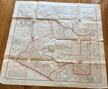
Map, Department of Lands and Survey Melbourne, Commonwealth Electoral Division of Fawkner, 1-10-1912
Shows a detailed street plan of South Melbourne, Albert Park, Prahran, South Yarra and parts of Melbourne in 1912. Used to mark the electoral boundaries of the Commonwealth Electoral Division of Fawkner. Shows all the then cable tram lines, rail lines and the electric line of the PMTT along with docks, gardens and significant buildings.Gives details of the Fawkner Electoral district in 1912.Folded sheet - Map - Commonwealth Electoral Division of Fawkner - two colours showing the subdivisions and polling placesmelbourne, fawkner, tram lines, cable trams, maps, electoral maps, south melbourne, albert park, prahran -
 Ringwood and District Historical Society
Document - Department of Lands and Survey, Wire Netting Branch, Melbourne, Victoria, Application for Vermin-Proof Fence Certificate - L.J. Mills vs John Collins, Grandview Grove, Ringwood, Victoria - 1939
Photocopied file of corresponence and documentation relating to a claim by L.J. Mills, Nurseryman, that adjoining property owner, J. Collins, Farmer, assists with replacement of a vermin proof wire netting dividing fence destroyed by 1939 bushfire. File includes 1939 and 1940 detailed property inspection reports by Vermin and Noxious Weeds Branch, Lands Department, Lilydale, describing land use in the area and signs of vermin activity. Application approved 18th April, 1940. Appeal lodged by Mr Collins disallowed in May, 1940. File closed June, 1940 with Departmental suggesion that Mr Mills consider further legal action through a Solicitor as fence had still not been wire-netted. TRANSCRIPTS: Vermin & Noxious Weeds Inspection Reports "19/9/1939 (To) Superintendent (Department of Lands and Survey, Melbourne) Re L.J. Mills application for Vermin Proof Fence. I called on Mr Mills yesterday 18th instant in connection with this matter. Mr Mills has a flower farm and claims that rabbits and hares are damaging his flowers. He showed me a bed of carnations which he stated were being damaged by rabbits. There was evidence of some leaves being nipped off, but I am unable to say whether this is due to rabbits or grubs. Very little if any real damage is being done. The property is netted on the east and south boundary and on half the north and west boundary. The surrounding country is undlating and fairly steep in places. The land to the east across Grandview Avenue (sic) is all planted out in old established orchards and well cultivated. Cleared grass land adjoins the south boundary and bush land adjoins the north and west boundaries. I walked over a large area surrounding Mr Mills land and never saw any rabbits or hares or any indications of rabbits. This locality is not rabbit infested and very little wire netting is being used. I do not consider that a vermin proof fence is necessary between these allotments. - Jas H Allison (Inspector, Vermin and Noxious Weeds Branch, Lands Department, Lilydale)." Follow up report following renewal of application for Certificate by Mr Mills, citing rabbits causing considerable damage to his flowers. He laid poison and obtained 9 carcases and stated that there is evidence of rabbit infestation from the adjoing land. "19/3/1940 (To) Mr Hannah (Superintendant, Department of Lands and Survey, Melbourne) Re L.J. Mills, Grandview Grove Ringwood, Lot 4 Grandview Estate Pt CG20 Ph of Warrandyte. I interviewed Mr Mills at his home on 15th inst. He showed me carcases of rabbits which he stated had been poisoned on his land. In places young plants had been nipped off apparently by rabbits. I made an inspection of adjoining properties and found one live burrow close to Mr Mills northern boundary. There were scratches and other evidence of rabbits on land north and west of Mr Mills property. In view of the present evidence of rabbits I consider that a vermin proof fence is now necessary to protect the flowers grown by Mr Mills. His land is netted on whole of east and south boundary and half way on west and north boundary. The adjoining land on west and north boundaries is owned by Mrs Linda Collins and John Collins resp of Brysons Road East Ringwood. - Jas H Allison (Inspector, Vermin and Noxious Weeds Branch, Lands Department, Lilydale)." -
 Kew Historical Society Inc
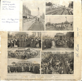
Article, The New Electric Tramway, Malvern to Kew
One of a group of photographs, including three within a published photo collage , taken by Edgar James Dower in the second decade of the twentieth century. Born and raised in Olinda, Dower later moved to Surrey Hills. He worked as an adult as a clerk in the city office of the Metropolitan Gas Company, and in his role as a 'collector', he was able to photograph scenes including the construction of tramlines, railways and associated buildings in Kew, Hawthorn, Camberwell and Surrey Hills. Later he established a real estate agency with his brother - the E.J. Dower Real Estate Agency, Mount Dandenong Office.The photo collage is an historically significant record of the development of transport infrastructure which was used to connect Victorians in the first two decades of the twentieth century. This development resulted from increases in population and the consequent extension of Melbourne's suburbs. The photographs, both individually and collectively, richly detail the labour of workers and the tools and machinery used to create and extend Melbourne's public transport network in the years preceding and during World War 1.Photo collage, published in The Leader newspaper in 1913, to commemorate the opening of the Malvern to Kew Tramway. The numbered photos are: 1. Kew Railway Gates at Glenferrie. 2. Burke Road Terminus. 3. Final Stages. 4. Ladies at the Official Opening. 5. The Acting Mayoress of Kew Cutting the Ribbon at the Kew Boundary. 6. Mayor and Councillors at the Kew Terminus. 7. The Cutting the First Ribbon. 8. Guests at the Hawthorn Town Hall.Inscribed in ink by Edgar J Dower top left: "The 3 top photographs were taken by E J Dower. No.3 Cotham Road Kew near Glenferrie Road"theme -- connecting victorians by transport and communications, theme -- travelling by tram -
 University of Melbourne, Burnley Campus Archives
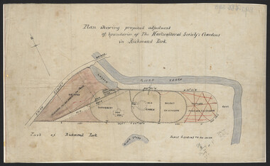
Plan, John S. Jenkins, Plan showing proposed adjustment of boundaries of the Horticultural Society's Gardens in Richmond Park, c.1880-1884
Plan on linen fibre cloth. Shows layout of Burnley bound by Swan St., Yarra River and part of Richmond Park, coloured areas showing proposed area to be added to Park, the old road, shrubbery, new hall, old garden, recent extension and proposed further extension (crossed out in red ink). Scale 4 chains:1 inch. Probably drawn by John S. Jenkins, Town Surveyor, Richmond. Has been photographed so that additional copies can be made. On a CD plus 3 negatives, plus small coloured print. (Also copy glazed and framed for Centenary Exhibition - B92.0540.)john s. jenkins, gardens, richmond, hoticultural society of victoria -
 Melbourne Tram Museum
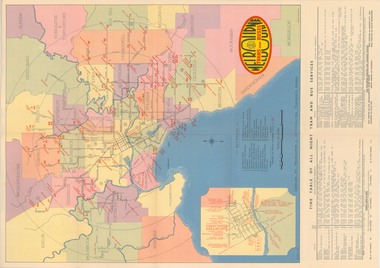
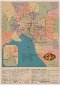
Map, Melbourne & Metropolitan Tramways Board (MMTB), "Map and timetable of Melbourne Tram and Bus Services" - March 1952", Mar. 1952
Fold out map (10 sections), coloured of Melbourne's Tram and Bus routes, route numbers, rail lines, municipalities boundaries and location of major places of interest. Titled - "Map and timetable of Melbourne Tram and Bus Services" - May 1952". At base of map - timetable of all night trams and bus services. On rear index to routes, 1st and last services, time of Sunday am services, Latrobe St. services and photo of Wattle Park. Dated March 1952 - Bourke St shown as bus. See Reg Item 413 for the May 1956 version. Very high resolution scans held. See also Reg Item 3720 for a MMTB Map of the same era.trams, tramways, melbourne, map, tram & bus services, all night services, mmtb -
 Melbourne Tram Museum
Document - Report, Melbourne & Metropolitan Tramways Board (MMTB), "Municipal Miles, late 1920's to mid 1930's
File- card, green grey - Rondo of London type, titled "Municipal Miles" - giving the calculations and background paperwork for the breakdown of the tramway system by municipality. Used late 1920's to mid 1930's. The top sheet, scanned, though superseded shows the route miles by double track, single track, shared at council boundaries and the total miles of track. See Reg Item 2083 for tram miles for the system as a whole - was this information required for rate valuation returns.trams, tramways, mmtb, trackwork, mileages, reports, councils -
 Melbourne Tram Museum
Ephemera - Map - Timetable, Melbourne & Metropolitan Tramways Board (MMTB), "Map and timetable of Melbourne Tram and Bus Services", March 1952
Map provided information about Melbourne's tramway network in 1952. At base of map - timetable of all night trams and bus services. On rear index to routes, 1st and last services, time of Sunday am services, Latrobe St. services and photo of Wattle Park. The conversion of Bourke St to electric trams marked up. Copy 1 - has been marked for hypothetical extensions in blue pencil mainly in the northern and western suburbs. In particular note the Ballarat Road and South Road markings. Copy 2 - has been marked up for newer route numbers, following the opening of the Bourke St services and additional route numbers on the Essendon Depot lines. Demonstrates the provision of information about Melbourne tram services.Fold out map (10 sections - 2 high x 5 wide), coloured of Melbourne's Tram and Bus routes, route numbers, rail lines, municipalities boundaries and location of major places of interest. melbourne, tram and bus services, mmtb, buses, trams, routes, timetables, all night services -
 Melbourne Tram Museum
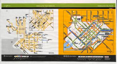
Poster, Yarra Trams, "Melbourne Tram Network", Nov. 2005
Full colour poster printed, A3 size, on laminated sheet - titled "Melbourne Tram Network. Shows a diagrammatic layout of the Melbourne tram system, shows zones (2 zones), CBD, tram terminuses including the City Saver boundary. Has the Yarra Trams and Metlink logos. Dated Effective November 2005trams, tramways, yarra trams, metlink, maps, metcard, tickets, city section -
 Ringwood and District Historical Society
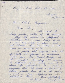
Letter - clipping, Letter to Town Clerk Ringwood 1939 from Ringwood East Primary re Footpath culvert
A letter dated 30 June 1939 to the Town Clerk Ringwood from E Thompson Ringwood East School Committee advising the Council that the culvert on footpath in Whitehorse Road is in a very bad state of repair. Also requesting that the footpatch be formed or continued along from the Burnt Bridge to the municipal boundary. -
 Melbourne Tram Museum
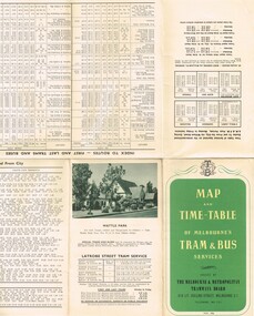
Map, Melbourne & Metropolitan Tramways Board (MMTB), "Map and timetable of Melbourne Tram and Bus Services" - May 1956", May. 1956
Fold out map (10 sections), coloured of Melbourne's Tram and Bus routes, route numbers, rail lines, municipalities boundaries and location of major places of interest. Titled - "Map and timetable of Melbourne Tram and Bus Services" - May 1956". At base of map - timetable of all night trams and bus services. On rear index to routes, 1st and last services, time of Sunday am services, LaTrobe St. services and photo of Wattle Park. Dated May 1956. Note the inset map shows Bourke St as a bus. Three copies held. 413.1 - as for above but with a pasted over section titled "Time table of all - night bus services" on the base of the map replacing the all night tram and bus services. Dated 3/7/1957. Copy from donation of Gary Butler added 3/12/15. See Reg Item 2300 for the March 1952 version.trams, tramways, melbourne, map, tram & bus services, all night services, mmtb -
 Melbourne Tram Museum
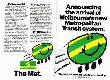
Pamphlet, The Met, "Announcing the arrival of Melbourne's new Metropolitan Transit system", late 1983
Set of 9 pamphlets about the Neighbourhood ticket system - basically the same with changes for each neighbourhood. .1 - Eight page, A4, colour printed on gloss paper, centre stapled, titled "Announcing the arrival of Melbourne's new Metropolitan Transit system - Ringwood Neighbourhood" Explains the revised ticketing system, known as Neighbourhoods, notes the formation of The Met, uses a cartoon characterisation of vehicles, explains how the system works, boundaries, various options, travel cards, concessions and introductory offers. Pamphlet focused on the Ringwood Zone, has a detailed map of the public transport routes within the zone. 2nd copy added 14-5-2016 from the estate of Charles Craig. .2 - Inner .3 - St Albans .4 - Dandenong .5 - Box Hill - (two copies held) .6 - Frankston .7 - Moorabbin .8 - Greensborough .9 - Werribee - added 26/10/2016.trams, tramways, map, the met, tickets, fares, ringwood