Showing 606 items
matching department store
-
 Kew Historical Society Inc
Map, MMBW, MMBW Plan No.117 Heidelberg & Kew, 1900-1910
The Melbourne and Metropolitan Board of Works (MMBW) was established by an act of the Victorian Parliament in 1890 to prepare for and to implement a sewerage and water reticulation system across what was then inner Melbourne, its surrounding and middle distance suburbs, including Kew. The MMBW was disbanded in 1991.The map collection of the Kew Historical Society has at its core the historic maps assembled and originally stored in the City Engineer's Department of the City of Kew. These include maps in a number of scales. The vast majority of maps were produced by the MMBW in the first two decades of the twentieth century, and are solid working maps, backed by linen for durability. These maps are historically significant to Kew, the City of Boroondara and to the history of the development of state utilities in Victoria. A number of the Kew maps have additional details added by former municipal officers, including the levels reached by various floods. As these were working documents, information was added to them long after the period of their initial production and distribution.Early map of part of the Borough of Kew, created in the early twentieth century, at a scale 160 ft to 1 inch. The map covers what was then the north eastern part of Kew showing the natural landscape and limited development on the south side of the Yarra River. In the Kew section, south of the river, the land is occupied currently by the Greenacres and Kew Golf Clubs. The map shows the extent of urban development by that time and the outlines of the few built structures in the municipality. The height above sea level of all parts of the landscape are indicated numerically in feet. Contour lines and the levels of historic floods were added in ink to the map at a later stage. MELBOURNE AND METROPOLITAN BOARD OF WORKS / PLAN NO. 117 / HEIDELBERG & KEW melbourne & metropolitan board of works, mmbw maps, borough of kew, cartography, mmbw plan no. 117, kew (vic.) -- maps, heidelberg (vic.) -- maps -
 Kew Historical Society Inc
Map, MMBW, River Yarra Beautification Schemes, c.1913
The Melbourne and Metropolitan Board of Works (MMBW) was established by an act of the Victorian Parliament in 1890 to prepare for and to implement a sewerage and water reticulation system across what was then inner Melbourne, its surrounding and middle distance suburbs, including Kew. The MMBW was disbanded in 1991.The map collection of the Kew Historical Society has at its core the historic maps assembled and originally stored in the City Engineer's Department of the City of Kew. These include maps in a number of scales. The vast majority of maps were produced by the MMBW in the first two decades of the twentieth century, and are solid working maps, backed by linen for durability. These maps are historically significant to Kew, the City of Boroondara and to the history of the development of state utilities in Victoria. A number of the Kew maps have additional details added by former municipal officers, including the levels reached by various floods. As these were working documents, information was added to them long after the period of their initial production and distribution.Map of the City of Kew showing part of the River Yarra Beautification Schemes. The map shows development to date and the flood levels reached in 1923 and 1924. This map may have been adapted from an earlier map, as most development in central Kew and Studley Park had occurred by this date yet numerous streets are not represented. Public buildings and institutions are clearly represented and named on the map as are significant public transport infrastructure (eg the Outer Circle railway).MELBOURNE AND METROPOLITAN BOARD OF WORKS / RIVER YARRA BEAUTIFICATION SCHEMES / SCHEME / SCALE 10 CHAINS TO AN INCHmelbourne & metropolitan board of works, mmbw maps, mmbw plans, city of kew, flood levels -- kew (vic.), cartography -
 Kew Historical Society Inc
Archive (series) - Subject File, McDonalds (Fast Food Restaurant)
Kew Historical SocietySince its foundation in 1958, members of the Kew Historical Society have been compiling and storing information about subjects relating to the history of Kew and its environs, of which this file is an example. Arranged by Secondary Values (value of records to users)Subject file created by researchers of the Kew Historical Society containing information about the McDonald's fast food franchise in High Street, Kew. The file contains a number of primary and secondary sources including newspaper cuttings, planning objections, correspondence between KHS, the City of Kew, the Administrative Appeals Tribunal, and the Department of Conservation and Natural Resources etc. The file also includes copies of the plans for the proposed restaurant. mcdonalds fast food franchises, mcdonalds restaurant -- kew (vic.), administrative affairs tribunalmcdonalds fast food franchises, mcdonalds restaurant -- kew (vic.), administrative affairs tribunal -
 Surrey Hills Historical Society Collection
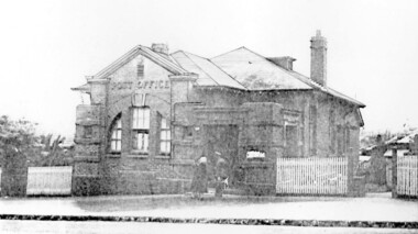
Photograph, Surrey Hills Post Office
The post office opened at this location in 1912. It was demolished in 2000. Post office history in the area: Until 1883 when the railway came through to Surrey Hills, this was essentially a rural community of scattered farms. Land subdivisions soon occurred along the railway line and limited postal services followed soon after, although a ‘permanent’ home for the post office was two decades away. George Sim Junior is acknowledged as our first postmaster; he opened a post office on 1 October 1884 in his father’s general store at 619-621 Canterbury Road, a few doors down from the Surrey Hills Hotel on the corner of Union Road. Over the next 20 years, the Surrey Hills Post Office moved several times into temporary, shared accommodation – in 1889 into Woodhead’s Corner Store at 364 Canterbury Road; then in 1895 to No 376, Hansen’s Exchange Building, part of Hansen’s Terrace (demolished) and in 1901 to 109 Union Road, on the corner of Windsor Crescent. Following Federation in 1901, the new Commonwealth Government established the Postmaster-General's Department to provide postal services to the nation. Many of the post offices constructed in the following years reflected a growing sense of Australian pride and nationalism. It was 1914 when building commenced on the ‘purpose-built’ post office at 609 Canterbury Road, Surrey Hills. Described as “a polychromatic Federation Freestyle building”, it served as the local post office for nearly 85 years until sold by the Commonwealth Government in c1999, after which the post office moved to the current, less prominent site at 100 Union Road. For nearly 10 years under private ownership, the building was successfully adapted for use as the base for two businesses, Gargoyles and Dragons and later the Surrey Sculpture Studio, and fortuitously the historic integrity of the building was maintained. However although renovated in the 1990's, structurally sound and of historic significance, it was not protected under local or commonwealth heritage legislation and was demolished soon after sale. This is an early image of a demolished building which should have been protected. In 1991, when the City of Camberwell conducted a heritage study, (which still informs the basis of the City of Boroondara’s heritage guidelines for this part of the municipality,) the post office was owned by the Commonwealth Government. As such, it could not be considered for heritage listing by the local authorities. Some years later, the Commonwealth and Australia Post rather belatedly recognized not only that post offices have heritage and social value, but also that the architecture of post offices as community buildings is important. A heritage management scheme was developed for the buildings they own or control under the Environment Protection and Biodiversity Act 1999. Unfortunately, the Surrey Hills Post Office had been sold and demolished before this was finally enacted in 2004. Black and white image, perhaps from a post card, of Surrey Hills post office at 609 Canterbury Road. The building is flanked by a picket fence. There is a woman, a dog and a man in front of the entrance. The man is in uniform - possibly a postal employee.post offices, canterbury road, businesses, surrey hills post office, surrey sculture studio, gargoyles and dragons -
Vision Australia
Text, RVIB day report, 1958-1959
Daily report on the health of children who resided at the RVIB school and the medications that were administered to them during 1958 and 1959. Some activities undertaken by the children are also noted by staff who lodged both day and night reports in this volume. Loose documents have been stored inside the back cover: messages between the day and night staff, a letter to Matron from the City of Melbourne health department notifying her of an immunisation visit in 1959, and a copy of an outward letter to the Lady Superintendent of the Royal Children's Hospital regarding a post-graduate student group visit on February 10, 1959. 1 v.On cover "Minute book".rvib burwood school -
University of Melbourne, Burnley Campus Archives
Booklet, Department of Agriculture, Insect Pests of Stored Grain, 1938
... of the Department of Agriculture of Victoria Insect Pests of Stored Grain ...insects, pests, grain, dept of agriculture, r t pescott -
Friends of Ballarat Botanical Gardens History Group
Work on paper - Adam Lindsay Gordon Plaque, Mrs Ida Buckley to Mayor of Ballarat, 8/01/1934, 8/1/1934
... &Nunn Department store, an important part of the Melbourne ...Mrs Ida Buckley wrote to the Mayor of Ballarat concerning a plaque in memory of Adam Lindsay Gordon, where it should be positioned within Craig's Hotel. Mrs Buckley requests copies of the Courier when there is an account of the unveiling of the plaque.The Adam Lindsay Plaque Is part of the Gordon history in Ballarat, considered important in 1934. It is interesting to note that Mrs Ida Buckley was married to the son of the highly respected Buckley&Nunn Department store, an important part of the Melbourne retail scene until well into the twentieth century. 1 typed sheet of correspondence of Mrs Ida BuckleyOne correction in black biro "Nunn".john garner, doctor, john garner collection, ballarat botanical gardens, friends of ballarat botanical gardens, mrs ida buckley, james fennings, adam lindsay gordon plaque, australian poet, mr angus greenfield, mr darling, ballarat courier, westminster abbey, gardens, ballarat -
 Mont De Lancey
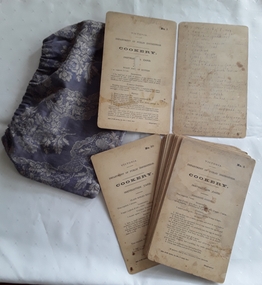
Functional object, Department of Public Instruction Victoria, Cookery Instruction Cards, not dated, but c. 1887 - 1906
The set of 30 cards were used by Miss Frida Striezel 1898. A rare, interesting set of numbered 1 - 30 cardboard cookery instruction cards - The Department of Public Instruction, Victoria Australia. They instructed how to prepare very Australian dishes with an English influence - e.g., Yorkshire Pudding, Pea Soup, Steak and Kidney Pie. The Government Printer's name indicates these were produced between 1887 and 1906. The cards are stored in a purple floral damask drawstring bag. There is handwritten sheet of paper with the above information.Handwritten in grey pencil at the top of every card is 'Frida Striezel'. On the back of Card 2 is handwritten in faded black ink No 1 -30 the title of the 30 recipes on the cards. On a separate sheet of paper handwritten in black fineline marker pen - '584 SET 30 COOKERY INSTRUCTION CARDS. DEPT OF PUBLIC INSTRUCTION Date - between 1887 and 1906'cookery cards, recipes, instruction books, cooking -
 Lakes Entrance Historical Society
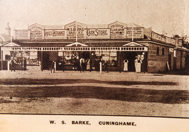
Photograph - Barke's Store, 1900c
This extensive weatherboard store was built in 1893 at a cost of one thousand pounds, architect was H French, builder McKnockiter Bros and D Collins the plasterer. William Barke managed the general store, bakery and hardware, brother John Barke managed the clothing and fancy goods department. Building was demolished and replaced by Centrepoint Arcade in 1985-1986Sepia coloured photograph of Barke's Store, people in front of store. Lakes Entrance VictoriaW S Barke, Cunninghameretail trade, people -
![Map, [Coornmill land area available for leasing for grazing, Parish of Coornmill]. Circa 1904](/media/collectors/5e461d8021ea67224c82f2a1/items/677cde147f2053f3e5d277c3/item-media/677cdeea7f2053f3e5d27bb4/item-fit-380x285.jpg) Bacchus Marsh & District Historical Society
Bacchus Marsh & District Historical SocietyMap, [Coornmill land area available for leasing for grazing, Parish of Coornmill]. Circa 1904
This map shows an area of land north of Bacchus Marsh in the Larderderg State Park area known as the Parish of Coornmill.The map indicates an area of land which was to be made available by public tender for grazing leaseholders. The plan to do this was discussed in the Bacchus Marsh Express newspaper on the 16 July, 1904, page 2, column 7. The area reserved for grazing leases is identified by red lines on the map. The Express described the area available for grazing was 12,000 acres.A single page paper map showing an area of land in the Parish of Corrnmill to be made available for grazing leases. A photo lithographed Lands Department Map. No scale indicated. The map is pasted into a bound volume containing 76 maps or plans in total. High resolution digital image stored on BMDHS computer network. coornmill parish maps, lerderderg state park maps, agriculture bacchus marsh area -
 Bacchus Marsh & District Historical Society
Map, Village allotments, Parish of Myrniong, County of Bourke
Myrniong is a village 9 kilometers west of Bacchus Marsh. Prior to 1863 the area was known as Blow's Flat. This map which was produced in 1903 and according to the catalogue record of this map held at the State Library of Victoria was based on an earlier map created in 1861. The early layout of streets for the village of Myrniong can be seen on this map. The streets shown are, Main Street, Hardy Street, Blow Street, Myrniong Street, Shuter Street, and Blackwood Street. An area marked as a reserve for a school can be seen between Hardy Street and Main Street.A single page paper map. A cadastral parish map of Myrniong in Victoria, showing numbered land allotments. Photo-lithographed at the Department of Lands & Survey, Melbourne, in 1903. Based on an original map created in 1861. The map is pasted into a bound volume containing 76 maps or plans in total. High resolution digital image stored on BMDHS computer network. Surveyed by John Hardy, Surveyor ; photo-lithographed at the Department of Lands & Survey, Melbourne by T.F. McGauran, 24.12.03myrniong parish plan, myrniong parish maps -
 Bacchus Marsh & District Historical Society
Map, Parwan Parish Map, County of Grant, 1909
A single page paper map showing the map for the Parish of Parwan in the County of Grant. A cadastral map showing parish boundaries and land ownership. The map is pasted into a bound volume containing 76 maps or plans in total. High resolution digital image stored on BMDHS computer network. Photo-lithographed at the Department of Lands and Survey, Melbourne by T.F. McGauran, 7.7.09. bacchus marsh region parish plans, parwan parish maps, parwan parish plan -
 Bacchus Marsh & District Historical Society
Map, Trentham Parish Map 1905 Copy 1
A single page paper map showing the map for the Parish of Trentham in the Counties of Dalhousie and Bourke. A cadastral map showing parish boundaries and land ownership. The map is pasted into a bound volume containing 76 maps or plans in total. High resolution digital image stored on BMDHS computer network. Photo-lithographed at the Department of Lands and Survey, Melbourne by T.F. McGauran 22.3.05 trentham parish maps, trentham parish plan, bacchus marsh region parish plans -
 Bacchus Marsh & District Historical Society
Map, Coimadai Parish Map, County of Bourke. Circa 1890s-1900s
The cadastral Parish of Coimadai, a subdivision of the County of Bourke, lies directly north of the township of Bacchus Marsh. The date of this map is uncertain. T.F. McGauran the person who made a photo-lithographic copy of the map was in charge of photo-lithography at the Victorian Department of Lands and Survey in the late 19th century until about 1910.A single page paper map showing the map for the Parish of Coimadai in the County of Bourke. A cadastral map showing parish boundaries and land ownership. A rectangle shaped area is missing from the centre of the map due to a tear or deliberate excision. The map is pasted into a bound volume containing 76 maps or plans in total. High resolution digital image stored on BMDHS computer network. Photo-lithographed at the Department of Lands and Survey, Melbourne by T.F. McGauran 26.8.[??] NOTE. Photo litho from L.P showing temporary surveys and occupation of land prepared for departmental use onlybacchus marsh region parish plans, coimadai parish maps, coimadai parish plan -
 Bacchus Marsh & District Historical Society
Map, Blackwood Parish Map, County of Bourke, 1892
A single page paper map showing the map for the Parish of Blackwood in the County of Bourke. A cadastral map showing parish boundaries and land ownership. The map is pasted into a bound volume containing 76 maps or plans in total. High resolution digital image stored on BMDHS computer network. Photo-lithographed at the Department of Lands and Survey, Melbourne by T.F. McGauran 14.7.92bacchus marsh region parish plans, blackwood parish plan, blackwood parish maps -
 Bacchus Marsh & District Historical Society
Map, Blackwood Parish Map, County of Bourke, 1905
A single page paper map showing the map for the Parish of Blackwood in the County of Bourke. A cadastral map showing parish boundaries and land ownership. The map is pasted into a bound volume containing 76 maps or plans in total. High resolution digital image stored on BMDHS computer network. Photo-lithographed at the Department of Lands and Survey, Melbourne by T.F. McGauran 21.7.05bacchus marsh region parish plans, blackwood parish plan, blackwood parish maps -
 Bacchus Marsh & District Historical Society
Map, Myrniong Parish Map, County of Bourke, 1882
A single page paper map showing the map for the Parish of Myrniong in the County of Bourke. A cadastral map showing parish boundaries and land ownership. The map is pasted into a bound volume containing 76 maps or plans in total. High resolution digital image stored on BMDHS computer network. Photo-lithographed at the Department of Lands and Survey, Melbourne by J. Noone, 17.7.82myrniong parish plan, myrniong parish maps, bacchus marsh region parish plans -
 Bacchus Marsh & District Historical Society
Map, Parish of Yangardook, County of Bourke 1876
The parish of Yangardook lies directly north of the township of Melton. The locality of Toolern Vale lies in the centre of this parish. A single page paper map showing the plan for the Parish of Yangardook in the in the County of Bourke. Scale 40 chains to 1 inch. The map is pasted into a bound volume containing 76 maps or plans in total. High resolution digital image stored on BMDHS computer network. Photo lithographed at the Department of Lands and Survey, Melbourne by J. Noone, 1.8.76yangardook parish maps, toolern vale victoria maps -
 National Vietnam Veterans Museum (NVVM)
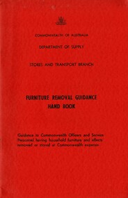
Booklet, Australian Army, Commonwealth of Australia: Department of Supply: Stores and Transport Branch: Furniture Removal Guidance Hand Book
A red coloured covr with black information. At the bottom of the booklet reads Guidance to Commonwealth Officers and Service ersonnel having household furniture and effects removed or stored at Commowealth expense. The booklet is held together by two rusty staplescommonwealth of australia, department of supply, stores and transport branch, furniture removal -
 Surrey Hills Historical Society Collection
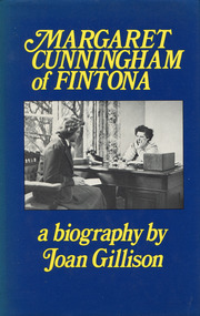
Book - Margaret Cunningham of Fintona: a biography by Joan Gillison, 1982
... a time as welfare superintendent at a large department store, she ...The subject of this biography is a redoubtable and unusual woman. Born in 1900, Margaret Cunningham was educated at Clyde and Melbourne University where she took a science degree, not a common choice for women in those days; then, after a time as welfare superintendent at a large department store, she went to London to train as a teacher. Back in Melbourne she joined the staff of Fintona, a girls' school which she later bought and transferred to a new site. From 1936 to 1962 in partnership with deputy principal Miss Beatrice Chilvers, she shaped a school which tried to make the most of every student's talents and fostered co-operation and goodwill among staff and pupils.A 22 cm H book with 231 p, and includes an index, appendix and notesnon-fictionThe subject of this biography is a redoubtable and unusual woman. Born in 1900, Margaret Cunningham was educated at Clyde and Melbourne University where she took a science degree, not a common choice for women in those days; then, after a time as welfare superintendent at a large department store, she went to London to train as a teacher. Back in Melbourne she joined the staff of Fintona, a girls' school which she later bought and transferred to a new site. From 1936 to 1962 in partnership with deputy principal Miss Beatrice Chilvers, she shaped a school which tried to make the most of every student's talents and fostered co-operation and goodwill among staff and pupils.cunningham, 1900-, fintona girls' school, teachers -- victoria -- melbourne -- biography, margaret cunningham -
 Bendigo Historical Society Inc.
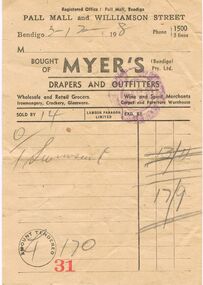
Document - MYER'S INVOICE
Sydney Myer was born in Russia in 1878 and came to Australia in 1896. He was initially a travelling salesman before opening a drapery store in Bendigo in 1900. In 1908 he opened a second store in Bendigo. In 1911 he purchased Wright and Neil Drapery in Bourke Street. This led to the formation of the Myers Emporium that became the largest chain of department stores with branches in all states and territories.Myer's Invoice: Cream paper with black print. Registered Office : Pall Mall, Bendigo. Pall Mall and Williamson Street. Bendigo 3/2/198 (sic) Phone 1500, 3 lines. Bought of Myer's (Bendigo) Pty Ltd. Drapers and Outfitters. Wholesale and Retail Grocers. Ironmongery, Crockery, Glassware. Wine and Spirit Merchants Carpet and Furniture Warehouse. Sold By 14. Lamson Paragon Limited. Exd By. Purchased was: 1 Swimsuit at 17/9. Amount Tendered 170 Invoice no. 31. Purple stamp with paid on. Small tear. Box 625business, retail, myer's store, myer's bendigo -
 Bendigo Historical Society Inc.
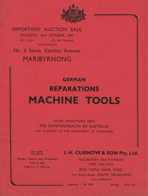
Document - IAN DYETT COLLECTION: AUCTION CATALOGUE - GERMAN REPARATIONS MACHINE TOOLS
Red cover, catalogue for a sale of German Reparations Machine Tools under instruction from The Commonwealth of Australia (on account of the Department of Munitions) at No. 2 Store, Maribyrnong on 23/10/1947. Special Notice and Conditions of Sale printed in catalogue. J. H. Curnow & Son Pty. Ltd. were the auctioneers.business, auctioneers, j h curnow & son pty ltd, ian dyett collection - auction catalogue - german reparations machine tools, the commonwealth of australia, the department of munitions, j h curnow & son pty ltd, the prahran telegraph printing co -
 National Vietnam Veterans Museum (NVVM)
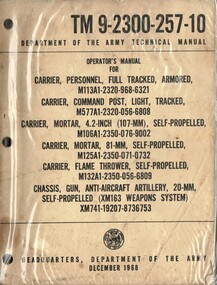
Manual, United States Army, Operators Manual for Carrier, Personnel, Full Tracked, Armored M113A1 etc
A cream coloured cardboard cover with black information on the cover. Top right hand corner reads TM 9-2300-257-10 and under this reads Department of the Army Technical Manual. At the bottom reads Headquarters, Department of the Army December 1968. There are three punch holes down the left hand side. The manual is stored in a plastic cover for protection.united states - armed forces - service manuals, m113, 81mm mortar, flame thrower -
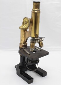 Damascus College
Equipment - Microscope and Insect Specimens
... College students from 1948. This microscope had been safely stored... students from 1948. This microscope had been safely stored ...An Ernst Leitz Wetzlar microscope (1910) used by St Paul's College students from 1948. This microscope had been safely stored by the Science department at Damascus College before being transferred to the archives in 2021. Specimens stored and used with this microscope were collected by the teaching staff and students from the local area throughout the 1950s.Bronze and Bakelite microscope manufactured by Ernst Leitz Wetzlar in 1910E. Leitz Wetzlar No 129200science, biology -
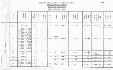 Melbourne Tram Museum
Document - Report, Melbourne & Metropolitan Tramways Board (MMTB), "Passenger Tram Fleet", 21/12/1964 12:00:00 AM
Duplicated two page foolscap sheet, stapled in the top left hand corner, issued by the MMTB Engineering Department - titled "Passenger Tram Fleet", as at 21/12/1964. Lists all bogie trams, numbers, class, number in service, stored, to be sold, Tare weight, length and width, roof height, number of doors and seated / crush capacity loads. Has form G.43 in top right hand corner.trams, tramways, tramcars, lists, mmtb -
 Bacchus Marsh & District Historical Society
Map, Mooradoranook Parish Map, County of Grant
A single page paper map showing the map for the Parish of Mooradanook in the County of Grant. Cadastral map showing land ownership. The map is pasted into a bound volume containing 76 maps or plans in total. High resolution digital image stored on BMDHS computer network. Photo lithographed at the Department of Lands and Survey Melbourne by T. F. McGauran, 27.11.06mooradoranook parish maps, mooradoranook parish plan, bacchus marsh region parish plans -
 Bacchus Marsh & District Historical Society
Map, Mouyong Parish Map, County of Grant
A single page paper map showing the map for the Parish of Mouyong in the County of Grant. Cadastral map showing land ownership. The map is pasted into a bound volume containing 76 maps or plans in total. High resolution digital image stored on BMDHS computer network. Photo lithographed at the Department of Lands and Survey Melbourne by T. F. McGauran, 9. 4. 07mouyong parish plan, mouyong parish maps, bacchus marsh region parish plans -
 Flagstaff Hill Maritime Museum and Village
Photograph - Historical, building, Late 19th to early 20th century
The black and white photograph depicts the Lady Bay Lighthouse Complex at Flagstaff Hill, Warrnambool. It was opened on this site in 1871. From left to right, the Chartroom (previously named the Store), Upper Lighthouse, Flagstaff, Lighthouse Keeper's Quarters. The bluestone buildings are facing North on Merri Street. The Harbour Pilot's Lodgings were on the east of the Complex. There are two unknown male figures standing in front of the light-coloured picket fence that encompasses the Complex. The photograph is mounted on card. WARRNAMBOOL'S LADY BAY LIGHTHOUSES In the 1800s ships sailing from England to Australia began to use Bass Strait as a faster route to Melbourne. Small navigation errors led to many tragic shipwrecks. From 1848 lighthouses were operating along Victoria’s southern coast as a guide for sailors. Coastal towns such as Warrnambool grew and the exchange of trade and passengers was of great benefit. However, the uncertain weather changes, relatively shallow waters and treacherous, hidden rocky reefs were not really suitable for a Harbour and in the 1840s and 1850s, there were many shipwrecks in the area, with some even stranded in its Lady Bay harbour. A jetty was built in 1850 and a flagstaff to guide seafarers was placed up high on what became known now as Flagstaff Hill. In November 1857 the Victorian Government recommended that Warrnambool Harbour had beacons and two lighthouses to guide vessels into and out of the Harbour safely. The white light of the Middle Island lighthouse was to be used for the first time on September 1, 1859. The red light of the Beach Lighthouse, a wooden obelisk structure, was first operated on March 25, 1860, but in 1868 this light was ‘discontinued’ due to it being too low. Melbourne’s Department of Public Works decided to relocate the Middle Island Lighthouse Complex - Lighthouse, Keeper’s Quarters, Privy, Store Room and even water tanks - to Flagstaff Hill. The lower obelisk was shortened, and a protruding gallery, railing, and external ladder were added, and the light from the Beach Lighthouse. A green guiding light was erected on the end of the jetty. The transfer of the Complex began in March 1871. Each shaped stone of the lighthouse was carefully numbered, removed then reassembled on Flagstaff Hill. In 1872 the well was sunk behind the Lighthouse Keeper’s Cottage. The Keepers and families had left Middle Island in April and moved to Flagstaff Hill in October 1871. Vessels entering Lady Bay align the Upper and Lower Lighthouse towers during the day and the lights at night. The Upper Lighthouse is a round tower, and the Lower Light is square. The Lighthouses were categorised as harbour lights rather than coastal lights, so they remain under the control of the Victorian Government’s Ports and Harbours section. The lights were originally powered by oil, then acetylene gas, later by electricity, and then converted to solar power in 1988. In 1993 the solar panel was replaced by a battery charger. A decision was made in 1936 to replace the lighthouses’ lights with unattended lights that no longer required Keepers and Assistants. At least 29 Keepers had attended to the lighthouse from its opening in 1859 to when the last official Lightkeepers left In April 1916. The Warrnambool Harbour Board rented out the Quarters from 1916 to 1936. The Board closed down but the rentals continued with other unknown landlords. In the 1970s the Flagstaff Hill Planning Board was set up under the chairmanship of John Lindsay. The Board was to make recommendations to the Warrnambool City Council regarding using the buildings and the rest of the Crown Land on the site. The Flagstaff Hill Maritime Village opened in 1975 and began renovating the Cottage in stages, during which time evidence of a 1920s fire was found in the eastern section of the cottage. Additions of a porch on the west and a washroom on the east were made in the 1980s. The western part of the building is now a Shipwreck Museum and the east has returned to a late 19th-century Lighthouse Keeper’s cottage and includes the screen made by Assistant Lighthouse Keeper Thomas Hope in the late 19th century. He served as Assistant Keeper in Warrnambool for two periods.The Warrnambool Lighthouse Complex is now listed on the Victorian Heritage Register, H1520, for being of historical, scientific (technological) and architectural significance to the State of Victoria. The Complex is significant as an example of early colonial development. The buildings are significant for their connection with the important navigational function of the Lighthouses, a function still being performed to this day. The buildings are also significant as an example of structures designed and works carried out by the Public Works Department in Victoria in the mid-to-late 19th century. The structures still stand strong. Photograph; Warrnambool Lighthouse Keeper's cottage, lighthouse, flagstaff and chartroom at Flagstaff Hill, and a light-coloured picket fence with gate. Two male figures are in front of the fence. Black and white print glued to a yellow card. The inscription is indecipherable. The right side of the cottage has a built-in, enclosed addition.Ink stamped in lower right hand corner, too faded to be legible.flagstaff hill, flagstaff hill maritime museum, flagstaff hill maritime village, warrnambool, maritime museum, shipwreck coast, lighthouse keeper's cottage, lighthouse residence, lighthouse, chart room, quarters, privy, middle island, beach lighthouse, obelisk, lighthouse complex, lady bay complex, warrnambool port, warrnambool harbour, lady bay, keepers, lighthouse keeper, upper lighthouse, lower lighthouse, assistant keeper, ports and harbours, cottage -
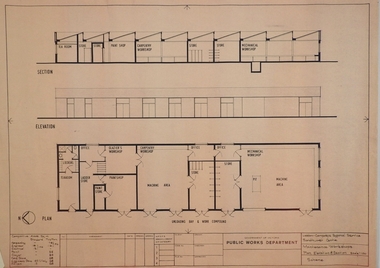 Bendigo Historical Society Inc.
Plan - SANDHURST BOYS CENTRE COLLECTION: PLAN OF MAINTENANCE WORKSHOPS
Victoria Public Works Department. Sandhurst Boys Centre. Maintenance workshops plan, elevation & section, Scale 1:100. Elevation includes tea room, lockers bathroom; ladder store; glaziers workshop; paint shop & paint store; carpentry workshop; machine area; offices, store rooms; mechanical workshop. Location unknown 16.02.2023.bendigo, institutions, sandhurst boys centre, sandhurst boys centre site plans; maintenance workshops; loddon-campaspe regional service; victoria public works department -
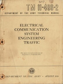 National Vietnam Veterans Museum (NVVM)
Manual, United States Army, Electrical Communication System Engineering Traffic, 1956
A brownish coloured cardboard cover with black information on the front. Top right hand reads T M 11-486-2 and under this reads Department Of The Army Technical Manual. At the bottom of the cover is the insignia of the United States of Americal War Office with the Department Of The Army . August 1956. There are three punch hles down the left had side and there is evidence that the manual was held together with some form of metal as there are rust areas around the holes. The manual is held together with one rusty staple at the top left hand corner. The manual is stored in a plastic bag.united states - armed forces - service manuals, electrical communications systems engineering, technical manual, department of the army, united states war office