Showing 3566 items matching "environments"
-
 Nillumbik Shire Council
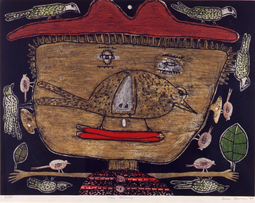
Print (etching): Dean BOWEN, The Offering, 1997
Dean Bowen is renowned for his charming, child-like aesthetic and unique thematic interplay between the urban and rural as well as humans and animals. Bowen has developed a distinctive and humorous symbolic language that filters through each work. His highly charismatic and whimsical renderings of animals, human characters and Australian environments celebrate the vicissitudes of life, evincing the simple pleasures of human habitation within the artificial and the natural world. The work and thoughts of Jean Dubuffet, particularly those which focus on the philosophy of 'Art Brut', give support to Dean's belief that untrained artists are more honest, that artists interested in emulating the art of children are trying to regain the pure expression they lost with childhood. 'The Offering' was a finalist in the Nillumbik Art Awards in 1997. The work refers to the act of giving back, rather than taking which Bowen sees as more prevalent in our Western society. While the image is childlike, the expression of the boy is a mixture of sadness and happiness, knowing and naivety, youth and age. The smile has a Mona Lisa quality and the earthy and sensuous colours suggest landscape. When realising the images he relies on memory rather than observation so that the struggle with drawing and representation sometimes doesn't work. The style of the drawing and the flat space relates to the graphic style of cartoons and caricature. The intuitive and the imaginative are essential elements in his work. lower right 'Dean Bowen '97' -
 Bayside Gallery - Bayside City Council Art & Heritage Collection
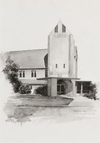
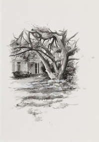
Work on paper - ink and watercolour, Annette Meikle, Church of England, 1977
In 1977, artist Annette Meikle undertook a commission to illustrate a book recording stories of places and people in the Bayside area. It was published in 1978 as Sandringham Sketchbook, with text by Elizabeth Waters. The sketches were intended to record remaining examples of Bayside’s early architecture and environment, as well as reflect newer architectural changes. Meikle went on to donate 22 of these sketches to Bayside City Council in 2003. All Souls Memorial Church, located at 48 Bay Road, Sandringham, is believed to be the first reinforced concrete church in Australia. The foundation stone laid on 7 September 1919 and was consecrated in December 1921, the church seats 350 and contains an organ loft, a marble chancel floor, and Australian hardwood pulpit and pews.Annette Meikle, Church of England 1977, ink and watercolour, 35.6 x 25 cm. Bayside City Council Art and Heritage Collection. Donated by the artist, 2003annette meikle, sandringham sketchbook, elizabeth waters, all souls memorial church, church, building, architecture, bay road, sandringham, church of england -
 Eltham District Historical Society Inc
Slide - Photograph, Sensory Integration Invention A, Cathy Smith (1999), Fergusons Paddock, Arthurs Creek Road, Hurstbridge, c.Nov. 2001
Sensory Integration Invention A, by Cathy Smith public art sculpture, commissioned by Nillumbik Shire Council, in Fergusons Paddock,12 Arthurs Creek Road Hurstbridge was officially unveiled in 1999. Councillors Penny Mullinar and Margaret Jennings in attendance. "Smith's work has strong references to humans' sensory and practical relationship with the land through the built environment. Wind entering the structure's tubing operates like a flute, generating sounds such as bird calls that resonate into the surrounding wetland areas." Source: Highlights from the Nillumbik Public Art Collection, NSC, n.d. Part of a slide show presentation "A Trip Down the Diamond Creek" by Russell Yeoman to the Eltham District Historical Society meeting of 14 Nov. 200135mm colour positive transparency Mount - Black and Whiteart in public places, arthurs creek road, cathy smith, ferguson's paddock, hurstbridge, public art, sensory integration invention a -
 Vision Australia
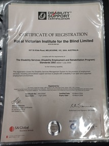
Certificate - Text, Certificate of Disability Support Certification registration, April 2003, 1 April 2003
Certificate reads "Certificate of Registration. Royal Victorian Institute for the Blind, 557 St Kilda Road, Melbourne VIC 3004 Australia complies with the requirements of The Disability Standards (Disability Employment and Rehabilitation Program) Standards 2002, dated July 1 2002 for the following capability: This registration covers the Disability Services Management System for the provision of employment services, including personalised support services to people with a disability in an open and supported employment environment." Signed: Alex Ezrakhovich, General Manager Certification. Certificate #: DSC20047. Issue Date: 1st April 2003. Certified Date: 19th March 2003. Expiry Date 19th March 2006. The second certificate reads the same except for 201 High Street, Prahran.2 certificates with black writingAt the top of the page is a black and white image of a shell next to 'Disability Support Certification' which also has a red tick across the first 2 words.royal victorian institute for the blind, registration -
 Broadmeadows Historical Society & Museum
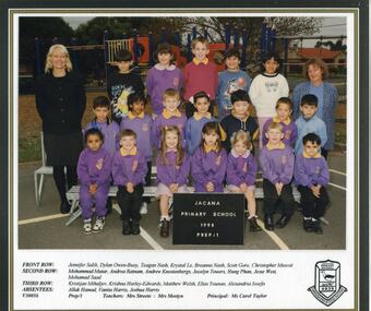
Photograph - School Photo, Fotek School Portraits, Jacana Primary School Grade Prep/1 1998, 1998
This group photograph of the Grade Prep/1 class at Jacana Primary School, taken in 1998, stands as a meaningful testament to the school’s lasting impact on the Jacana community. Founded in 1959 and active until the early 2000s, Jacana Primary was more than an educational institution—it was a vital hub of community life. Through decades of service, it fostered a spirit of inclusion, learning, and shared experience that shaped the lives of countless students and families. The image not only preserves the youthful faces of its students but also encapsulates the values of camaraderie, diversity, and belonging that were central to the school’s ethos. As a visual document, it offers valuable insight into the everyday experiences of school life and reflects the broader social and educational environment of Jacana during that era.The 1998 Grade Prep/1 class photograph from Jacana Primary School holds enduring historical and cultural value as a representation of the school’s pivotal role within the Jacana community. Established in 1959 and operated until the early 2000s, Jacana Primary was a foundational institution that contributed significantly to the educational and social development of the area. This image is significant not only as a record of the students and staff of that time but also as a reflection of the school’s inclusive and community-oriented ethos. It embodies the values of diversity, belonging, and collective identity that defined the school’s culture. As a visual artifact, it offers insight into the lived experiences of local families and the broader educational landscape of late 20th-century suburban Melbourne. The photograph serves as a tangible link to the past, preserving the memory of a place that shaped generations and fostered a strong sense of community connection.A vibrant laminated colour photograph featuring a group of children and staff seated in three rows. Their names are displayed on a white panel, printed on glossy paper, accompanied by the school logo.jacana primary school, education, photograph, group photograph, ms carol taylor, 1998, jennifer salib, dylan owen-buoy, teagan nash, krystal le, breanna nash, scott gore, christopher muscat, mohammad matar, andrea ratnam, andrew knostenbergs, jocelyn towers, hung phan, jesse west, mohamad saad, kristijan mihaljev, krishna hurley - edwards, matthew welsh, elias younan, alexandria ioseka, allak hamad, vanita harris, joshua harris, mrs. pam streete, mrs. linda mostyn -
 Broadmeadows Historical Society & Museum
Photograph - School Photo, Fotek School Portraits, Jacana Primary School Grade 3/4 2000, 2000
This group photograph of Jacana Primary School students and teachers, taken in the year 2000, serves as a meaningful reflection of the school’s lasting presence in the Jacana community. Founded in 1959 and operating until the early 2000s, Jacana Primary was more than a place of education—it was a central part of community life, fostering connection, learning, and shared identity across generations. The image documents not only the individuals present at the time but also the school’s broader cultural values—camaraderie, diversity, and a strong sense of belonging. As a visual record, it offers valuable insight into the everyday life of the school and the social environment of Jacana at the turn of the century. It stands as a testament to the role Jacana Primary played in shaping young lives and strengthening community bonds.This 2000 group photograph of students and teachers at Jacana Primary School is a significant cultural and historical artifact that reflects the enduring legacy of the school within the Jacana community. Established in 1959 and operating until the early 2000s, Jacana Primary was a cornerstone of local life, providing not only education but also a sense of identity, belonging, and continuity for generations of families. The photograph is important as a visual record of the school’s final years, capturing the diversity, camaraderie, and inclusive spirit that defined its culture. It offers insight into the social and educational environment of the time and serves as a tangible reminder of the school’s role in shaping the lives of its students and contributing to the broader social fabric of the suburb. As a preserved image, it holds value for former students, educators, and the wider community, symbolising shared memories and the collective history of Jacana. A vibrant laminated colour photograph featuring a group of children and staff seated in three rows. Their names are displayed on a white panel, printed on glossy paper, accompanied by the school logo.jacana primary school, education, photograph, group photograph, 2000, ms. carol taylor, grade 3/4, teagan nash, jovie anne orca, belinda tracey, whitney sammut, krishna hurley-edwards, jamana matar, jade lloyd, matthew sinnett, kristijan mihaljev, stephanie melta, benjamin grubbergs, andrew knostens, allak hamad, jocelyn towers, clara david, trent gore, andrew fuimaono, maeve-aine oakley, matthew welsh, joshua harris, emre akbiyik, ms. farnsworth, mr. bojczuk, mrs. nancy fry -
 The Beechworth Burke Museum
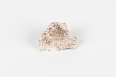
Geological specimen - Opal Bearing Stone, Unknown
There are 17 opal fields in Australia. This opal bearing stone was found in Lightning Ridge, NSW over what is known as the Great Australian Basin. This basin was formed and covers an area of 1.7 million square kilometers in eastern Australia in the Cretaceous period. This basin used to contain an inland sea, which provided an environment where silcrete eventually formed when water levels changed. This eventually seeped into other structures, and eventually hardened and formed opal. Lightning Ridge has a population of around 2000 people, with about 80 000 visitors every year. It is a historic mining town, and is known for its deposits of a rare black opal. Mining started in the area in the late 1800s, early 1900s when the black opal was discovered. This opal-bearing stone is of social and historical significance. It is from Lightning Ridge, which is well-known for being a large producer of opal stones, most famously black opal. The history of the period dates back to 140 million years, with the discovery of black opal in the early 1900s causing interest in the area. This specimen is part of a larger collection of geological and mineral specimens collected from around Australia (and some parts of the world) and donated to the Burke Museum between 1868-1880. A large percentage of these specimens were collected in Victoria as part of the Geological Survey of Victoria that begun in 1852 (in response to the Gold Rush) to study and map the geology of Victoria. Collecting geological specimens was an important part of mapping and understanding the scientific makeup of the earth. Many of these specimens were sent to research and collecting organisations across Australia, including the Burke Museum, to educate and encourage further study.***A palm-sized solid mineral specimen in shades of beige and light orange*** silica based? burke museum, beechworth, geological, geological specimen, opal, opal fields, australia, lightning ridge, new south wales, great australian basin, cretaceous, silcrete, black opal, mining -
 The Beechworth Burke Museum
Photograph
This image shows an unknown location in the area of Beechworth that was possibly used as a sluicing mining site for gold during the Victorian Gold Rush. This era saw an influx of Chinese immigrants and Australian prospectors hoping to strike it rich on the fields. Many companies such as the Rocky Mountain Extended Gold Sluicing Company Ltd and the Cocks Pioneer Gold &Tin Sluicing Company also set up mines in the area. This site may be the location of one of these company's mines. The wooden logs are reminiscent of known sluicing operations in the era from that time. Sluicing involved the use of high-pressured hoses to clear away soil from earth that had been dug up by miners and was a popular method of excavation in the area, although it had severe impacts on the environment.The search for gold is ingrained into the history of Victoria and therefore, images like this one which portray an open cut sluicing site can reveal important information for society and technology for the date when the photograph was taken. This image is of important historical significance for its ability to convey information about sluicing and the methods used to find gold. It also shows a location where sluicing was undertook which provides insight into the impact of sluicing on the environment at a time when it was done.A colour rectangular photograph printed on glossy photographic paperReverse: 6855 /beechworth, gold rush, sluicing, mining -
 Warrnambool and District Historical Society Inc.
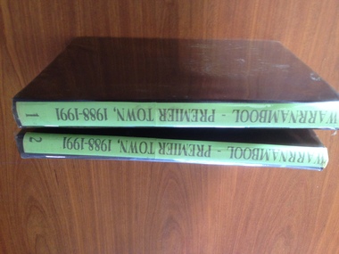
Book - Album, 1988-1991 Premier Town Volume 2, Circa 1988
The Premier towns is an award given by the Victorian state Government. It recognises positive actions by regional communities to protect and enhance their local environment. It is based on criteria relating to litter prevention and waste management, environmental and heritage management as well as activities among community groups and leadership. The following is taken from Hansard at the announcement of the awards in 1988 That the Senate- (a) congratulates the Mayor, Councillors, the Premier Town Committee, and the people of the City of Warrnambool, Victoria, for their achievement, on Saturday, 20 November 1988, in taking out the Victorian `Premier Town Award' for an unprecedented third time; (b) congratulates the business people of Warrnambool for their efforts in helping the city to win the Victorian Industrial and Commercial Development Award, including a special award for coastline preservation and studies This album is significant in that it documents an important award to the City of Warrnambool. It is also a comprehensive pictorial record of Warrnambool as it was in 1988.Volume 2. Covers Warrnambool rivers, bridges, coastal features, places of learning, clubs and sporting facilities and historical and general interest all of which have played an important role in the development of and history of the city and lives of its people.Soft brown vinyl cover with plastic cover. Pages are dark cream cover paper. A sticker with the Warrnambool Premier Town logo is inside the front cover. The album consists of photographs of various buildings and streetscapes with relevant descriptive text.Sticker inside front cover, Mr J Gietz Po Box 1007 Warrnambool Vic 3280. warrnambool, ideal town 1988-1991, victoria’s bicentennial premier town premier town awards -
 Eltham District Historical Society Inc
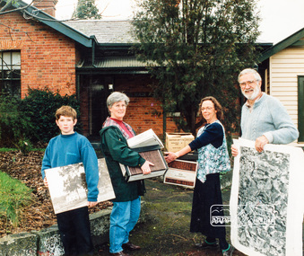
Photograph, Diamond Valley Leader, Eltham Local History Centre, former Police Residence, 728 Main Road, Eltham, 1998
Members of the Eltham District Historical Society transfer collection items from storage into their new home. Previously occupied by the Parks and Environment Department of Nillumbik Shire Council (L-R: Mark Gillham, Margaret Ball Vice President, Sue Law Immediate Past President, Harry Gilham President) Nillumbik Shire Council Commissioner Vin Heffernan (1996-97) worked with Harry Gilham to obtain use of the former Eltham Shire Parks and Gardens office at 728 Main Road for use by the Society. Harry as a younger man had played in the scrum for Heidelberg Football Club along with Vin's brother who was on the wing. Apparently Heffernan was able to access $30K to spend on the site to fix it up for occupation.Colour photo print 12.5 x 19 cmLeaser Newspaper Groupmargaret ball, mark gilham, police residence, sue law, 728 main road, activities, eltham, eltham district historical society, harry gilham, justice precinct, local history centre -
 Eltham District Historical Society Inc
Photograph, Eltham Local History Centre, former Police Residence, 728 Main Road, Eltham, 1998
Members of the Eltham District Historical Society transfer collection items from storage into their new home. Previously occupied by the Parks and Environment Department of Nillumbik Shire Council (L-R: Mark Gillham, Margaret Ball Vice President, Sue Law Immediate Past President, Harry Gilham President) Nillumbik Shire Council Commissioner Vin Heffernan (1996-97) worked with Harry Gilham to obtain use of the former Eltham Shire Parks and Gardens office at 728 Main Road for use by the Society. Harry as a younger man had played in the scrum for Heidelberg Football Club along with Vin's brother who was on the wing. Apparently Heffernan was able to access $30K to spend on the site to fix it up for occupation.Colour photographeltham district historical society, harry gilham, margaret ball, mark gilham, sue law, local history centre, 728 main road, activities, eltham, justice precinct, police residence -
 Kiewa Valley Historical Society
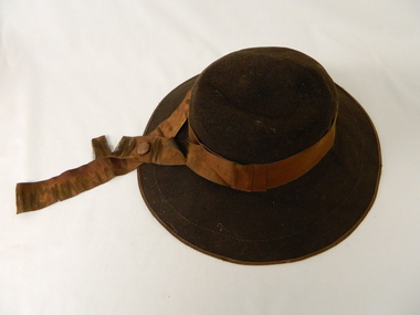
Hat Child's Felt, Circa mid 1900's
This brown wool felt hat with a broad brim was, by its style, used by a adolescent child for church services. This was worn in a period where church services on Sunday was an important weekly ritual by the whole family. Special (church only) dresses and hats were worn not only to show respect to the church but also part of expected community mores relating to religious beliefs. This behavioural pattern was more entrench in the rural communities than within larger cities. The closeness of smaller rural communities is the main factor regarding social norms. The visible standing within the community was uppermost. The period pre 2000 was a more coheasive family environment ( due to greater intra family activities) which provided better communication and family activities.This "church styled" hat is very significant to the rural lifestyle and its mores. It clearly demonstrates the coheasive force that religion has on the Valley population. The closeness that the semi isolation (at this time) brought about by the Valley's physical land formation and the poor roads within the valley brought families closer together. Not turning up for important social functionsw was duely noted by all (and frowned upon). Mrs E. Fisher lived at Mongan's Bridge in the Kiewa Valley.Brown child's all felt hat size 6 1/4. A broad brim with a lighter brown velvet ribbon head band. Head band has a crossover to the left front with 100 mm extension flowing over the brim. The top of the inside of the head pocket is lined with a soft silk fabric.6 and one quarter (size tag). Unreadable crest / monogramchildren's head wear, social head dress, church hats -
 Kew Historical Society Inc
Plan, Melbourne & Metropolitan Board of Works : Borough of Kew : Detail Plan No.1571, 1904
The Melbourne and Metropolitan Board of Works (MMBW) plans were produced from the 1890s to the 1950s. They were crucial to the design and development of Melbourne's sewerage and drainage system. The plans, at a scale of 40 feet to 1 inch (1:480), provide a detailed historical record of Melbourne streetscapes and environmental features. Each plan covers one or two street blocks (roughly six streets), showing details of buildings, including garden layouts and ownership boundaries, and features such as laneways, drains, bridges, parks, municipal boundaries and other prominent landmarks as they existed at the time each plan was produced. (Source: State Library of Victoria)This plan forms part of a large group of MMBW plans and maps that was donated to the Society by the Mr Poulter, City Engineer of the City of Kew in 1989. Within this collection, thirty-five hand-coloured plans, backed with linen, are of statewide significance as they include annotations that provide details of construction materials used in buildings in the first decade of the 20th century as well as additional information about land ownership and usage. The copies in the Public Record Office Victoria and the State Library of Victoria are monochrome versions which do not denote building materials so that the maps in this collection are invaluable and unique tools for researchers and heritage consultants. A number of the plans are not held in the collection of the State Library of Victoria so they have the additional attribute of rarity.Original survey plan, issued by the MMBW to a contractor with responsibility for constructing sewers in the area identified on the plan within the Borough of Kew. The plan was at some stage hand-coloured, possibly by the contractor, but more likely by officers working in the Engineering Department of the Borough and later Town, then City of Kew. The hand-coloured sections of buildings on the plan were used to denote masonry or brick constructions (pink), weatherboard constructions (yellow), and public buildings (grey). This plan is the other half of Plan No.1571 representing the constructions to the west of Wellington Street before and in 1903/4. This plan represents the built environment in Edgevale Road, Wellington Street, Atkins Street, Annadale Street, Mortimer Street, and Cotham Road. Whereas there are smaller allotments and more modest housing stock facing Edgevale Road, larger blocks and more substantial houses are represented facing Cotham Road.melbourne and metropolitan board of works, detail plans, mmbw 1571, cartography -
 Orbost & District Historical Society
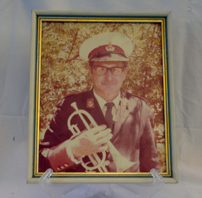
framed coloured photograph, 1978
This is a photograph of Alf R. Barling who was the bandmaster of the Orbost Municipal Band from 1961 - 1978. He played bass and cornet. This photographer, Peter Fagg, worked as a scientist with the Department of Sustainability and Environment (now DELWP) to study dieback in eucalypts. He specialised in the silviculture of the eucalypt forest types of South-East Australia for most of his 40-year career, which started with the Forests Commission Victoria. He was in Orbost from 1968 - 1973. The first Orbost Brass Band was formed in 1889. Around 1908 the town band split and the Orbost Workers' Band was formed. Eventually the two bands merged in 1913 to reform as the Orbost Municipal Band under conductorship of Charles Spink. Further info and Ref: In Times Gone By - Deborah Hall The various Orbost bands over the years played a major role in community activities providing entertainment and musical experiences for the many members.A coloured photograph of a man in a band uniform holding a brass instrument ( a cornet?). The photograph has been taken outdoors. The photograph is in a frame with gold esges.on back - Alf R. Barling 1977barling-alf orbost-municipal-band -
 Warrnambool and District Historical Society Inc.
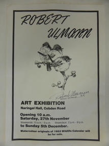
Poster, Poster for Robert Ulman exhibition, 1982
This is a poster advertising an art exhibition by the Warrnambool artist, Robert Ulmann. The exhibition was held in the Naringal Hall in November/December 1982. Robert Ulmann (1927-1999) was born in Zurich, Switzerland where he studied sculpture and painting. After living in Canada for some time he came to Australia in 1969. From 1970 to 1972 he was employed by the Northern Territory Administration as a manual arts instructor to the aboriginal people of Docker River west of Uluru. He exhibited extensively in city and regional galleries and won numerous awards for his artistic works. His love of wildlife extended to his interest in the Southern Right Whale and he was greatly responsible for publicizing the annual appearance of the whales at Logans Beach in Warrnambool and protecting their environment. His studio in Warrnambool is still visited by many tourists. This poster is of interest as it concerns an art exhibition of the work of Robert Ulmann, a well-known Warrnambool artist of the 20th century. This is a sheet of white paper with black edging. It is an advertisement for a Robert Ulmann Art Exhibition. The page has a sketch of three birds with Robert Ulmann’s signature underneath. robert ulmann, history of warrnambool -
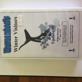 Warrnambool and District Historical Society Inc.
Audio Visual, Warrnambool Video Productions, Video - Winter Visitors, 1999
This videotape has material related to the annual arrival in Warrnambool’s coast (mainly at Logan’s Beach) of Southern Right Whales. These whales come annually to the Western District coastline about May and stay until about October. and some calve at Logan’s Beach – hence the name Logan’s Beach Whale Nursery. The whales have become an important tourist attraction in the area. Most of the whales return to the area regularly and have been named from their particular markings. Wilma the whale was a great favourite and was seen about every three years in Warrnambool but is now appearing in other parts of Australia. The tape is dedicated to Robert Ulmann who was a well-known artist and conservationist in the Warrnambool region. He did much to ensure the whales received protection and publicity in the Warrnambool environment. This tape is now in an outdated format and will be transferred to a more appropriate form as the material in it needs to be preserved. The whale migration to Warrnambool is a significant natural history event and material from the 1990s is important. This is a videotape in a black case with a white label with black printing pasted on. The outer box is white with a white label with blue and black printing. An image of a whale is on the outer label. ‘Warrnambool’s Winter Visitors’ ‘Update 98 Wilma Returns 7thJune 1999’ ‘This video dedicated to the memory of Robert Ulmann’ ‘Canya Dantz perform the song, Warrnambool Whale Wash’ whales in warrnambool, robert ulmann -
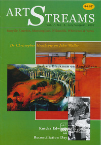 Eltham District Historical Society Inc
Journal, Peter Doughtery, ArtStreams: Banyule, Darebin, Manningham, Nillumbik, Whittlesea & Yarra; Vol. 7, No. 3, Jul-Aug 2002, 2002
Vol. 7, No. 3, Jul-Aug 2002 CONTENTS Comment 2 Home Country: The Art of John Waller 3 by Dr Christopher Heathcote Short Story: Meeting People Andrew Hutchinson 7 Strange Memories Barbara Blackman on the art of Anna Glynn 10 Walking the Talk 12 Reconciliation in Eltham World Environment Day 13 Poetry news and reviews 14 John Jenkins Australian Classical Music 15 Elizabeth Scarlett Short Story: The Thinkers Library 16 Trevor Hay CD Reviews Kerri Simpson, Brian Brown 22 Book Review Ecological Pioneers 24 Coffee 25 Australian Landscape Conference 26 How many birds is that? 28 Artin' About 29 Wining & Dining 30 Artin' About 32 "Peter Dougherty has been involved in the local art scene for many years. As publisher and editor of the arts magazine Artstreams, his comments on the various branches of the arts are widely respected. His "The Arts" column in the Diamond Valley Leader presents a brief summary for a much wider cross section of the local community. Peter also operates his own gallery and the Artstreams Cafe at the St Andrews market. Peter has a wealth of knowledge about present day and historical aspects of local art and artists." - Eltham District Historical Society Newsletter No. 161, March 2005Colour front and back cover with feature articles and literary pieces with photographs and advertisements printed in black and white. 36 pages, 30 cm. Vol. 1, no. 1 (Nov. 1996) - Vol. 10, no. 5 (summer ed. 2005/06) art streams, winter in banyule, john waller, bundoora homestead, willy wonka's ice cream gourmet food, bibby's bahnhof cafe, eltham fullife pharmacy, andrew hutchinson, bulleen art & garden centre, dynamic vegies, montsalvat, anna glynn, aboriginal reconciliation, marg woiwod, mick woiwod, andrew ross museum, trevor hay, st andrews hotel, chris pittard, mary-lou pittard, eltham wiregrass gallery, thompson's pharmacy, heide museum of modern art -
 City of Moorabbin Historical Society (Operating the Box Cottage Museum)
Pharmacy, plastic test tube, 20thC
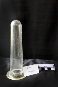
A test tube, also known as a culture tube or sample tube, is a common piece of laboratory glassware consisting of a finger-like length of glass or clear plastic tubing, open at the top, usually with a rounded U-shaped bottom. Test tubes are widely used by pharmacists to hold, mix, or heat small quantities of solid or liquid chemicals, especially for qualitative experiments and assays. Their round bottom and straight sides minimize mass loss when pouring, make them easier to clean, and allow convenient monitoring of the contents. The long, narrow neck slows down the spreading of vapours and gases to the environment. Test tubes are usually held in special-purpose racks. Culture tubes for biology are usually made of clear plastic (such as polystyrene or polypropylene) by injection moulding and are often discarded after use.A clear plastic test tubepharmacy, test tubes, plastic, culture test tubes, moorabbin, bentleigh, cheltenham, polypropylene, laboratories -
 Kiewa Valley Historical Society
Postcard Circa 1950, Mt. Beauty Village, Kiewa Hydro-Electricity Project, circa 1950
This postcard was produced in the 1950's for the tourist trade in the Kiewa Valley and Alpine region. It encompasses the period when the State of Victoria was pressured by the ever increasing demand by industry and its population for electricity supplies. Hydro electricity was seen as an untapped natural resource to quench this demand. The Victorian Alps and the rivers flowing into its valleys was ideal for the construction of the Kiewa Hydro Electricity Scheme. The late 1940's saw the development of this scheme and the changing of sections of alpine landscape is covered by this and other postcards/pictures (tourists, construction workers, and established rural populations). This period in time was before the established wildlife and forest/nature groups became political activist who changed legislative acts to protect the environment. The regulatory pondage on the northern aspect of the village had no water over-spill from the unfinished power station.This rural region in 1950 (Kiewa Valley/alpine plains) was at most only significant to a smaller group of winter sports, summer hikers/horse riders and rural farmers/graziers. The numbers of tourists and the increase in the local resident population was boosted by the construction of the Hydro Electricity Scheme. This influx to the regional population resulted in a corresponding diversity in services and brought about an environment that responded to a growing level of tourists and thereby permitting this industry to grow more rapidly than it would have naturally. This postcard details an attraction to the "cleaner" method of providing electricity. This postcard was purchased in 1950 by a surveyor at Landford's Gap. The couple shown in this photograph would have been employed by the S.E.C. under the Kiewa Hydro-Electricity Scheme.This item is a scanned black and white photograph of a panoramic view of Mount Beauty Village in 1950 (a closed village, entry by pass only). The regulatory pondage has earthen walls but no water.See 0480 (A) -(D) and (F) for other photos of similar postcards"MT. BEAUTY VILLAGE KIEWA HYDRO-ELECTRIC PROJECT"kiewa valley tourism, victorian alps, alternate energy supplies, alpine population growth -
 City of Moorabbin Historical Society (Operating the Box Cottage Museum)
Photograph, Black & White, Methodist Children's Home Cheltenham Boys & Briquettes 1935, 1935
Boys from the Methodist Children's Home Cheltenham collecting Briquettes from the shed. Briquettes, made from Brown coal, were an economical source of heating for the Home The Methodist Children's Home in Cheltenham was founded c1880 to provide housing for neglected children from the inner city. The Founders aimed to provide regular nourishment, a stable environment and integrate the children into the local community thereby improving their education and lives. ( see 00561) 1950's saw a new direction for the support of children and families in poor and difficult situations . The new Burwood Homes Facility opened in 1951 and children were transferred from Cheltenham in 1952. The land was sold to the St John of God, Catholic Order in1953 who maintained an orphanage until Myer Pty Ltd bought the site in 1967 and constructed the Southland Shopping Centrec1892-1953 The Methodist Children's Home Cheltenham was founded to provide safe accommodation and education for neglected children from the inner city slums. Black & White photograph of some boys in the Briquette Shed at Methodist Children's Home Cheltenham 1935Back Handwritten informationmethodist children's home cheltenham 1892-1953, briquettes, heating, yallourn brown coal mine, city of moorabbin, county of bourke, moorabbin roads board, parish of moorabbin, shire of moorabbin, henry dendy's special survey 1841, were j.b.; bent thomas, o'shannassy john, king richard, charman stephen, highett william, ormond francis, maynard dennis, cheltenham state school no.84, methodist chapel cheltenham, methodist school cheltenham, beaumaris west state school, meeres frederick, meeres walter, education, early settlers -
 Puffing Billy Railway
Notice Board - Victorian Railways Institute
Victorian Railways Institute - The VRI was formed in 1909, and started operations at the 3rd Floor, Flinders Street Station, on 31 January, 1910. The Commissioners of the day saw a need for a Social Organisation, where Railway Staff could come together and discuss common issues, and relax in a friendly environment. The VRI was also, for many decades, the Primary Educator of all Rail Staff in their Duties and Tickets, from Train Crews, Station staff and the like, through to the Accounting Office team, everyone was trained at the VRI on how to do their jobs in the VRI. At the height of its power, the VRI would lead a member base of 30,000+ Families, all who would have a dedication to the Rail Industry and VRI. Throughout the State, Centres started, the earliest in 1916 in Ballarat, through to the later ones in Sunshine (1962) and beyond.Historic - Victorian Railways Institute Notice BoardV.R Institute Notice Board made of painted timberV.R Institutepuffing billy, victorian railways institute, notice board -
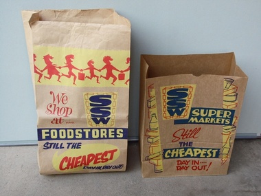 Sunshine and District Historical Society Incorporated
Brown Paper Grocery Bags
These type of brown paper grocery bags were commonly supplied by SSW Supermarkets, and also by other Supermarkets. The customers generally packed their own grocery purchases into the bags, while the checkout people were engaged in the time consuming process of accurately entering by hand, the price of each item into the cash registers. One local SSW Supermarket was situated on Sun Crescent in Sunshine. The introduction of stronger plastic film grocery bags and barcode scanning saved time, and the checkout person took over the role of packing the grocery purchases. In recent times customers who use the self check out terminals have again assumed the role of packing their own groceries. The environment polluting plastic bags however still remain, unless the customers bring their own 'green' bags.These two brown paper grocery bags provide a historical reminder of how grocery purchases were taken home from Supermarkets in the not too distant past. It is likely that many of the younger generation have no idea of how the paper grocery bags looked like, or that they were once used instead of plastic bags.Two brown paper bags which were available for free in SSW Supermarkets, so that customers could pack their grocery purchases to be able to take them home. The bags have SSW advertising printed on them in red, yellow, and navy blue inks.Large Bag: We Shop at .... SSW FOODSTORES STILL THE CHEAPEST DAY IN, DAY OUT! Smaller Bag: SSW SUPERMARKETS Still THE CHEAPEST DAY IN .... DAY OUT!brown paper grocery bag, ssw supermarket, food, grocery purchases, groceries. -
 Bayside Gallery - Bayside City Council Art & Heritage Collection
Work on paper - ink and watercolour, Annette Meikle, Chinese Elm - Corner Beach Road and Hampton Street, 1977
In 1977, artist Annette Meikle undertook a commission to illustrate a book recording stories of places and people in the Bayside area. It was published in 1978 as Sandringham Sketchbook, with text by Elizabeth Waters. The sketches were intended to record remaining examples of Bayside’s early architecture and environment, as well as reflect newer architectural changes. Meikle went on to donate 22 of these sketches to Bayside City Council in 2003. The Chinese Elm tree illustrated here marks the site of ‘Esmeralda’ which stood at at 312-314 Hampton Street, Hampton. It was a rambling house built in 1872 by Alfred William Harston and demolished in the 1970s. The elm is thought to be over 150 years old and was preserved by Council when flats were built on the site. It is recognised in the Significant Tree Register of Bayside City Council.Annette Meikle, Chinese Elm - Corner Beach Road and Hampton Street 1977, ink and watercolour, 33.8 x 23.7 cm. Bayside City Council Art and Heritage Collection. Donated by the artist, 2003annette meikle, sandringham sketchbook, elizabeth waters, chinese elm, esmeralda, alfred william harston, significant tree, historic house, hampton, hampton street -
 Federation University Art Collection
Work on paper - Printmaking - Relief Print, Starling, Anne, 'Innerwest' by Anne Starling, 2003
"In my woodblock print I have focused on the architectrure, streetscape and layout of the city. I am itrigued with teh organisation of cities and in teh creation of my own image. In this work I have almalgamated site drawings of buildings, streets and various structures to create a fish eye viewof the inner west of Sydney. By creating such a cityscape I form an historical document and record of the specific place."Anne STARLING (1967 - ) Born Sydney, New South Wales A graduate of the City Art Institute/UNSW College of Fine Arts, Anne Starling completed a Master of Art in 1994 and Master of Fine Arts by Research in 2012. Human interaction with the urban and industrial landscape is central to the work of Anne Starling. She focuses on the neglect that has occurred due to misuse and exploitation by industrial manufacturers, and the social and ecological structures of areas surrounding of Rhodes in Sydney, Fremantle in Western Australia and Port Kembla in New South Wales.Through relief and drypoint prints she examine changes that occur in this environment, presenting a commentary on the degradation and pollution of land by industry and the surrounding urban landscape. This item is part of the Federation University Art Collection. The Art Collection features over 2000 works and was listed as a 'Ballarat Treasure' in 2007.Framed black and white relief print (woodblock) representing a collage of various Sydney architecture. art, artwork, anne starling, printmaking, woodblock, print council of australia, sydney, architecture, bridge, cityscape -
 Parks Victoria - Mount Buffalo Chalet
Gauge, temperature
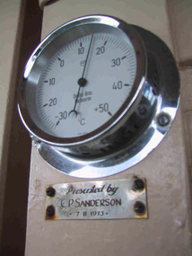
Appears to be original to Mt Buffalo Chalet. "A number of specific items, which have been useful in the day to day operations of the Chalet, remain in the building with each complementing the other to provide context, meaning and character to their setting. Items such as the hall porter bell, the many signs providing information to the guests, the wall clock, barometer and dinner bell point to the Chalet being a well-run social institution with a pleasant environment for rest, recreation and congenial company." (Pg 81 Historica, MBCC) This temperature gauge has a plaques inscribed "Presented by C.P Sanderson 7/08/1973. It is not known who this person was. Listed in Draft Inventory of significant Collection items. A.3 Fixtures and fittings. (Pg165 Historica Cultural Heritage Projects. Mount Buffalo Chalet collection. Prepared for Parks Victoria, 2011)Listed in Draft Inventory of Significant Collection ItemsSmall circular silver coloured temperature gauge mounted to wall. Plaque attached below temperature gauge. Face is white and has a glass cover.Plaque below barometer: "Presented by C P Sanderson / 7 - 8- 1973" -
 Federation University Art Collection
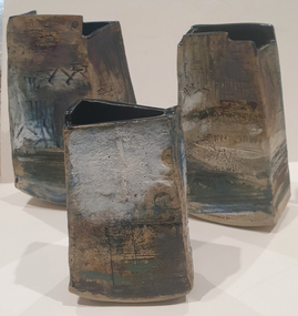
Ceramic, Sarah Canham, #Fliporflop 1, 2 & 3, 2021
'Home' is a symbol of hopes, dreams, comfort, love, family and future. It is both a place and an idea, nor does it remain in time and space. It can also represent a time of sadness , fear and loss. Through the roller-coaster of the past year, I have used a series of homes belonging to family and friends. Each artwork of home tells a different story about its occupants, their story, and what home mean to them. Sarah CANHAM Sarah has had a life-long love of creative arts and a passion for nature she has pursued in her career. She has a Bachelor Applied Science degree from Charles Sturt University, a Masters of Environment from University of Melbourne, and works in natural resource management and conservation. Studying part time Sarah Canham completed a Bachelor of Visual Arts at Federation University Arts Academy in 2021. Her art is an expression of the awe she has for the natural world, and concerns for the future, including for our indigenous culture, and native flora and fauna in Australia. She also reflects on the current and past women and mother artists who have experienced the challenge of juggling art, career and motherhood, and have been under-represented in the arts community for millennia.Three handbuilt, slab construction, stoneware formsceramics, sarah canham, dvc art award, alumni -
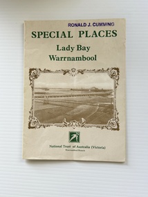 Warrnambool and District Historical Society Inc.
Pamphlet - Special Places Lady Bay Warrnambool, Philprint Warrnambool, 1989
This pamphlet was produced for the Warrnambool Branch of the National Trust of Australia (Victoria) for Heritage Week, April 16-23, 1989 and contains information written by Warrnambool residents about their locality. This was a co-operative venture by people with a common interest in protecting the natural environment near their home. Areas covered in the written information include: Formation of the Coast, Archaeological survey, Gunditjmara History, vegetation, history and recreational uses of the Lady Bay area. The map shows special places of interest including past and present navigational aids, sites of shipwrecks and other historical places of interest. The Warrnambool Branch of the National Trust was originally formed in March 1969 and merged with the Port Fairy Branch in late 1970. In October 1979, the Warrnambool Branch was reformed and operated into the late 1990's. This is an example of a publication produced by the Warrnambool Branch of the National Trust Australia (Victoria). It provides historical information and perspectives of the recreational uses in and around Lady Bay Warrnambool.An A2 piece of buff coloured thick paper folded into eight to make an A5 pamphlet. The front cover has green printing with the National Trust symbol of three eucalyptus leaves in green. There is a brown sepia photograph showing a view across Lady Bay with the suspension bridge across the Merri River in the foreground, Viaduct Road in the middle ground and the breakwater in the background. There is a purple inked stamp on the top right hand corner. The rear cover has brown writing and includes logos of bodies who assisted with the publication. There is a brown line drawing of the viaduct and pier at the Warrnambool Breakwater. The inside of the unfolded pamphlet contains a map of Lady Bay and adjacent area showing places of interest and shipwrecks marked in red circlesFront cover: Special Places Lady Bay Warrnambool National Trust of Australia (Victoria) Warrnambool Branch Ronald J. Cummingwarrnambool, lady bay warrnambool, national trust australia victoria warrnambool branch, heritage week 1989, lady bay shipwrecks -
 Falls Creek Historical Society
Booklet - Falls Creek Snowsports School Information and Trail map 2002
Part of yearly marketing and information material promoting the Falls Creek Ski School. This publication includes detailed information about the Falls Creek Snowsport School Program for 2002. An introduction by the School Director, Benny Pregenzer states "Our motto is improving our guests skiing and boarding in a fun and safe environment. The most important facets of a good instructor are patience and empathy. These are qualities that our instructors display in every lesson and together with successful teaching methods, will ensure you experience fast improvement. Our instructors are carefully selected from Australia and all over the world to provide the highest quality service possible. Have a great holiday and see you on the slopes." The brochure bears the logo of Nursing Australia, proud sponsors of the Falls Creek Snowsport School.This item is important because it documents seasonal activities at Falls Creek Snowsport School in 2002.A glossy booklet featuring images and information about programs to be offered at Falls Creek in the 2002 winter season. The front cover features a group of downhill skiers while the back cover is illustrated with an image of a female snowboarder. Coloured images are included throughout the booklet. The centre page includes a map of trails at Falls Creek.On front cover Falls Creek and the resort Logo fallscreek.com.au Snowsport Schoolfalls creek marketing, falls creek ski academy, falls creek race club, falls creek snowsport school. -
 Eltham District Historical Society Inc
Photograph, Former Eltham Police Residence, 728 Main Road, Eltham, c.1985, 1985c
This photo is believed to have been taken circa 1985 when the Shire of Eltham Parks and Environment occupied the site. This photo was originally mounted on 3mm MDF fibre board with notes and stickers applied as part of a display on the former Police Residence and now present day Local History Centre, home to Eltham District Historical Society; possibly put together by Harry Gilham during his time as president of the society. Eltham Police Station and Residence: A brief history 1860 Eltham Courthouse built in Main Road, together with an adjoining police residence, office, lock–up and stables. 1959 Police Department purchases a house in Pryor Street to be refurbished as Eltham Police Station 1961 Police in Eltham move into Pryor Street refurbished buildings and office. c.1961-1981 Occupied by Vermin and Noxious Weeds Destruction Section of the Department of Crown Lands and Survey. Former Police Station dragged around to rear of Police Residence (prior to August 1967) to make way for the construction of a driveway and access from Main Road. The building was placed on the site of a former Scullery and modified for Lands Department use. 1981 Shire of Eltham take over management of old Police Residence in Eltham. It remains unoccupied for a period of time whilst its future is discussed in Council. 1981-1985 Used for community job creation scheme 1985 Shire of Eltham Parks and Environment occupy the residence. Council improve the driveway but later add a second rear access from Brougham Street due to the dangerous nature of the Main Road entrance. Also add a rear toilet facility between the Police Residence and former Police Station, which was doubling up as a lunch room. Council also commence discussions to re-establish a replica Police Station. c.1986 November. Former Police Station demolished; believed to have been suffering termite damage. c.1989 After some years of discussion a replica Police Station is built, based on photographs, to act as a lunch room and meeting room for Parks and Environment staff and volunteers doing community service. 1996 Eltham District Historical Society in discussions with Nillumbik Shire Council commisioners throughout the year regarding a home for the Society. A proposal put forward by the Society in October to occupy the former Police Residence. 1997 March. Eltham District Historical Society gains access to former Police Residence. 1998 July 12th. Eltham District Historical Society Inc moves into its Local History Centre, 728 Main Road Eltham (the former Police Residnce built in 1860). 2018 July. Eltham District Historical Society gains access to the replica Police Station for use as part of regular heritage tours for schools and community based groups.Colour printHandwritten in faded blue felt pen ink "No. 3 - Front of 728 Police Residence. 1860 Court House over the paling fence. Verandah missing from earlier photographs"728 main road, eltham, local history centre, parks and environment, police residence, police station, shire of eltham -
 Eltham District Historical Society Inc
Photograph, Former Eltham Police Residence, 728 Main Road, Eltham, c.1985, 1985c
This photo is believed to have been taken circa 1985 when the Shire of Eltham Parks and Environment occupied the site. This photo was originally mounted on 3mm MDF fibre board with notes and stickers applied as part of a display on the former Police Residence and now present day Local History Centre, home to Eltham District Historical Society; possibly put together by Harry Gilham during his time as president of the society. Eltham Police Station and Residence: A brief history 1860 Eltham Courthouse built in Main Road, together with an adjoining police residence, office, lock–up and stables. 1959 Police Department purchases a house in Pryor Street to be refurbished as Eltham Police Station 1961 Police in Eltham move into Pryor Street refurbished buildings and office. c.1961-1981 Occupied by Vermin and Noxious Weeds Destruction Section of the Department of Crown Lands and Survey. Former Police Station dragged around to rear of Police Residence (prior to August 1967) to make way for the construction of a driveway and access from Main Road. The building was placed on the site of a former Scullery and modified for Lands Department use. 1981 Shire of Eltham take over management of old Police Residence in Eltham. It remains unoccupied for a period of time whilst its future is discussed in Council. 1981-1985 Used for community job creation scheme 1985 Shire of Eltham Parks and Environment occupy the residence. Council improve the driveway but later add a second rear access from Brougham Street due to the dangerous nature of the Main Road entrance. Also add a rear toilet facility between the Police Residence and former Police Station, which was doubling up as a lunch room. Council also commence discussions to re-establish a replica Police Station. c.1986 November. Former Police Station demolished; believed to have been suffering termite damage. c.1989 After some years of discussion a replica Police Station is built, based on photographs, to act as a lunch room and meeting room for Parks and Environment staff and volunteers doing community service. 1996 Eltham District Historical Society in discussions with Nillumbik Shire Council commisioners throughout the year regarding a home for the Society. A proposal put forward by the Society in October to occupy the former Police Residence. 1997 March. Eltham District Historical Society gains access to former Police Residence. 1998 July 12th. Eltham District Historical Society Inc moves into its Local History Centre, 728 Main Road Eltham (the former Police Residnce built in 1860). 2018 July. Eltham District Historical Society gains access to the replica Police Station for use as part of regular heritage tours for schools and community based groups.Colour printHandwritten in faded blue felt pen ink "No. 2 - Backyard of 728 #5 Weatherboard 'Office'. Note 1860 Court House over the fence."728 main road, eltham, local history centre, parks and environment, police residence, police station, shire of eltham