Showing 1101 items
matching information map
-
 Ballarat Tramway Museum
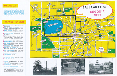
Pamphlet, Earl Ewers, "Ballaarat Begonia Festival - 1971", Sep. 2011
Yields information about the form of advertising the Ballarat Begonia Festival undertook and the relationship with Victour, the Victorian Govt. Tourist Bureau.Colour photocopy of a advertising brochure for the 1971 Ballaarat Begonia Festival - copied onto two A3 sheets. Has a map of the city showing the tram tracks, bowling greens, parks, and various locations. Gives Places to visit, programmes and Victour addresses and details. Originally published by the Ballaarat Begonia Festival Association and the Greater Ballarat Association and printed by Hedges and Bell. Three copies held. See Reg Item 2154 for the actual festival programme.trams, tramways, begonia festival, ballarat, map -
 Ballarat Tramway Museum
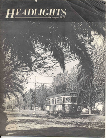
Magazine, John and Andrew Ward, "Headlights, July - August 1970", Jul. 1971
Yields information about the Melbourne tramway system from a USA viewpoint in 1970 and includes reference to Ballarat and Bendigo systemsTwenty four page (24) printed black and white magazine, titled "Headlights, July - August 1970" with a photo of Melbourne 944 on the front cover. Contains an article on the Melbourne Transport Plan for 1985 and "The Tramways of Melbourne" written by John and Andrew Ward. Contains maps, photographs, tramcar roster, drawing of the Melbourne W2, details of the W7's, the St. Kilda Junction project. Also notes other Australian operations including Ballarat and Bendigo. Published July 1971 by the Electric Railroaders Association of New York.trams, tramways, melbourne, mmtb, planning -
 Ballarat Tramway Museum
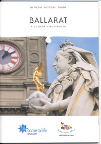
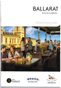
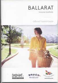
Book, The Ballarat Visitor Information Centre, "Official Visitors Guide, Ballarat, Victoria, Australia", 2008/09
Full colour, 84 page, book, A5 size titled "Official Visitors Guide, Ballarat, Victoria, Australia", with the upper part of the Queen Victoria statue and the Ballarat Town Hall in the background on the front cover. Gives details, maps accommodation listing, attractions etc of the Ballarat area. Pages 24 and 25 detail the Ballarat Tramway Museum and the BTM advertisement. Published 2009 by The Ballarat Visitor Information Centre.trams, tramways, ballarat, visitors, tourist guides, btm -
 Ballarat Tramway Museum
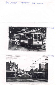
Document, Gold Museum, Royal visit tram 38, 1990's
Yields information about the photographic holdings of the Gold Museum, an din particular the preparation of No. 38 decorated for the Royal visit of 1954 and Bridge St Ballarat.Photocopy of two photographs from the Gold Museum Tramways Map Cabinet: 80-020b - No. 38 in Wendouree Parade, at depot junction receiving finishing touches in March 1954, prior to the Royal visit - See Reg Item 412 for a photo in Lydiard St Nth and other items. 80-020c - Bridge St looking West from Stones Comer, shows tram track, parked cars.Along top edge "Gold Museum Tramways Map Cabinet"trams, tramways, ballarat, royal visit, decorated trams, bridge st -
 Ballarat Tramway Museum
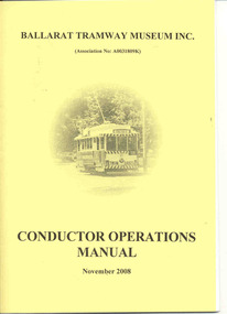
Document - Instruction Book, Ballarat Tramway Museum (BTM), "Conductor Operations Manual", 2009
Yields information about the operation of the BTM and the management of tramcar operations. Demonstrates how information within tram crews and shed staff was distributed.Twenty four page document within yellow card covers, folded A4 paper to form an A5 booklet titled "Ballarat Tramway Museum Conductor Operations Manual, November 2008". Provides details of the manual, index, operational procedures, map, requirements, many procedures, and some forms. Issued to existing workers and new workers at the time. See memo in back of worksheet for Reg item 4440 for details and mailing list.trams, tramways, btm, operations, instructions, procedures, conductors -
 Ballarat Tramway Museum
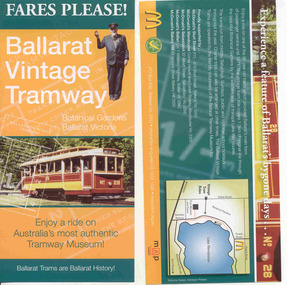
Pamphlet, Ballarat Tramway Museum (BTM), "Fares Please! / Ballarat Vintage Tramway", Aug. 2008
Yields information about how the BTM promoted the tramway, with the assistance of McDonalds. Design by the printer and Stephen Butler.Printed single sheet pamphlet, advertising BTM Vintage Tramway, titled "Fares Please!" featuring Frank Puls, a 1/- ticket and tram 26 on one side, map, details and McDonalds Wendouree on reverse. Printed in green, orange and black and white on light art paper. Includes BTM web address and McDonald's logo on rear, giving five locations of McDonalds, including the Western Highway at Ballan, Tourism and Museum Accreditation logos Introduced late August 2008. See Reg Item 2443 for previous version and 6123 for next version.trams, tramways, mcdonalds, btm, ballarat vintage tramway, botanical gardens -
 Ballarat Tramway Museum
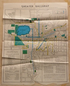
Map, Greater Ballarat Association and George Netherway, "Map of Ballarat", c1950
Yields information about Greater Ballarat, including trams, buses, locations and streets. Has a strong association with George Netherway.Four colour map of Ballarat, showing streets, places of interest, Parks, tram routes, bus routes, railway lines, prepared by G. C. Netherway, Greater Ballarat Association. Shows suburbs names, location of places of interest, some development north of Howitt St, in Wendouree. Map is part diagrammatic and is not entirely to scale. Includes the Lake Wendouree Rowing course On rear is a road map of the Ballarat area, lists of statistics, beauty spots, look outs, art and culture, points of historical interest, industrial products and recreation. Printed by Waller & Chester on paper produced by Ballarat Paper Mills Pty Ltd. See Reg item 2074 for photographic image of this version of the map. See Reg Item 2776 for another version of this map. Contained originally within Reg Item 5507 at the back of the binder. For items see btm5507 loose items list.pdf John Whiting in an email of 17-9-2021 noted: The rowing course along Lake Wendouree is noted, so perhaps this map is post 1956? The Mt Pleasant tram line is shown to terminate at Morton St, not Cobden St (which of course is incorrect) Someone's come along and drawn in black ink the branch of the View Point tram line!trams, tramways, ballarat, tram routes, bus routes, map, lists -
 Ballarat Tramway Museum
Magazine, Australian Railway and Locomotive Historical Society, "ARLHS Bulletin", 1943
Yields information about the tramways of Bendigo and the Geelong tramways and has a strong association with well known tramway enthusiasts of the era., Yields information about the tramways of Bendigo and the Geelong tramways and has a strong association with well known tramway enthusiasts of the era.Set of 12 Australian Railway and Locomotive Historical Society Bulletins for the period Jan 1943 to December 1943. Each page has been stencil duplicated. Index sheets for the journals at the front of the documents. March 1943 - pages 29 to 32 has an article "The Tramways of Bendigo - Bendigo Tramway Company Limited" written by Wal Jack. Has a large full page map prepared by C. C. Singleton. March 1943 - page 40 - has a short item on the St Kilda Brighton Tramway - three new tramcars (VR type). Item from the Journal of Victorian Model Railway Society" July 1943 - page 1 to 4, has an article "The Tramways of Geelong" - author not given, though probably largely Wal Jack. Has a large full page map prepared by C. C. Singleton. The Jan to June issues are loose, while the July to December issues have been hole punched and held together with a metal binder.museums bendigo, vr trams, geelong -
 Ballarat Tramway Museum
Book, The Ballarat Visitor Information Centre, "Ballarat Victoria's goldfields Official Visitor Guide", 2015
Full colour, 84 page, book, A5 size titled "Ballarat Victoria's goldfields Official Visitor Guide", with a photo of a people eating on the verandah of the hotel opposite the old post office. Gives details, maps accommodation listing, attractions etc of the Ballarat area. Page 14 detail the Ballarat Tramway Museum. Inside rear cover is a fold out map of the district, city centre, Buninyong and Mt Helen and Ballarat and Surrounds. Published 2015 by The Ballarat Visitor Information Centre. trams, tramways, ballarat, visitors, tourist guides, btm, gardens -
 Ballarat Tramway Museum
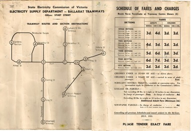
Poster - Digital Image, State Electricity Commission of Victoria (SECV), "Schedule of Fares and Charges - July 1951", Jul. 1951
Demonstrates the way the SEC provided information to passengers about the fares and sections and other charges on the Ballarat Tramway system.Printed poster on heavy cartridge paper showing Ballarat Tramway (SEC) Fares, Charges, and Section Map. Also gives charges for Scholar's Monthly tickets, Luggage, Parcels and Newspapers. Dated July 1951. Digital image btm6322i2.pdf scanned in 2011 from the Bill Kingsley collection. Added 12-11-2015 trams, tramways, ballarat, fares, sections, map -
 Ballarat Tramway Museum
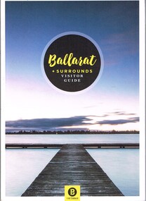
Book, The Ballarat Visitor Information Centre, "Ballarat + Surrounds Visitor Guide", 2016
Full colour, 144 page, book, A5 size titled "Ballarat + Surrounds Visitor Guide", with a photo of Lake Wendouree. Gives details, maps accommodation listing, attractions etc of the Ballarat area. Page 30 details the Ballarat Tramway Museum. Inside rear cover is a fold out map of the district, city centre, Buninyong and Mt Helen and Ballarat and Surrounds. Published 2016 by The Ballarat Visitor Information Centre. trams, tramways, ballarat, visitors, tourist guides, btm, gardens -
 Ballarat Tramway Museum
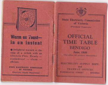
Photograph - Digital image, State Electricity Commission of Victoria (SECV), "Official Timetable Bendigo June 1940"
Yields information about the Bendigo Tram services.Digital image or copy of the SEC "Official Timetable Bendigo June 1940", 22 image files - 44 pages, giving details of the fares, transfers, luggage or parcels, lost property, times of each tram on the Quarry Hill, Eaglehawk, Lake Weeroona and Golden Square for both directions and Monday to Thursday, Friday, Saturday and Sunday. Has a number of advertisements for SEC home equipment, cookers, toasters, refrigerator, electric radiators and hot water. In the middle page is a map of the Tramway Routes, which has been hand drawn to shown North Bendigo and the depot location. Inside the rear cover, on a sheet headed "Memorandum" is a photograph, taped in of a conductor loading a pram onto a Birney tram. Under the photograph is in ink "Len Smith (Geelong)" See item3127 for an original copy and pdf scan. trams, tramways, bendigo, timetables -
 Ballarat Tramway Museum
Book, The Ballarat Visitor Information Centre, "Ballarat Victoria's goldfields Official Visitor Guide", 2012
Full colour, 100 page, book, A5 size titled "Ballarat Victoria's goldfields Official Visitor Guide", with an autumn view across Lake Wendouree. Gives details, maps accommodation listing, attractions etc of the Ballarat area. Page 13 detail the Ballarat Tramway Museum and the BTM advertisement on page 23. Inside rear cover is a fold out map of the district, city centre, Ballarat and Surrounds. Published 2012 by The Ballarat Visitor Information Centre. trams, tramways, ballarat, visitors, tourist guides, btm, gardens -
 Ballarat Tramway Museum
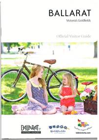
Book, The Ballarat Visitor Information Centre, "Ballarat Victoria's goldfields Official Visitor Guide", 2014
Full colour, 92 page, book, A5 size titled "Ballarat Victoria's goldfields Official Visitor Guide", with a photo of a lady and child with a bicycle behind. Gives details, maps accommodation listing, attractions etc of the Ballarat area. Page 16 detail the Ballarat Tramway Museum. Inside rear cover is a fold out map of the district, city centre, Buninyong and Mt Helen and Ballarat and Surrounds. Published 2014 by The Ballarat Visitor Information Centre. trams, tramways, ballarat, visitors, tourist guides, btm, gardens -
 Ballarat Tramway Museum
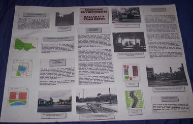
Poster, Georgia Foley, "Changing Environments - Ballarat Tram Depot", mid 1990's
Yields information from a students eyes about the history of the tram depot and how the associated environment changed and why. Has a strong association with the student.Poster prepared for a school assignment, titled "Changing Environments - Ballarat Tram Depot", features 6 photographs of the tram depot, maps, story boards pasted together onto a large sheet of heavy paper with Velcro mounts on the rear. Looks at the purpose, the location, the site characteristics, what changed, history, cause of change and likelihood of future change. Prepared by Georgia Foley Year 11C - school unknownTop right hand corner has the student's name in ink and on the rear a bibliography advising of Richard Gilbert's assistance.trams, tramways, depot, posters -
 Ballarat Tramway Museum
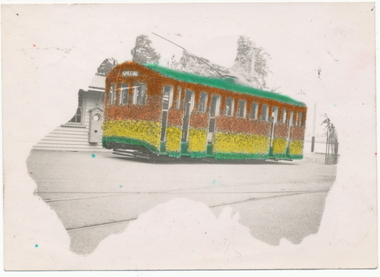
Photograph - Digital image, L.W. Torr Best Street Bowen Hill and Brisbane Q, 4/03/1939 12:00:00 AM
Yields information about Ballarat tram 29 when it was dressed for the Floral Festival and the launch of the tram and how it was used by a small photograph publisher for sales.Digital image from the Wal Jack Ballarat Album of a postcard featuring the 1939 Floral Tram, photograph at the depot, rendered in colour and positioned within an outline of a map of Australia. Wal's notes date it as 4-3-1939. Uses the same base photo similar to 1369, but without the motor bike in the rear. On the rear has a the stamp "L.W. Torr Best Street Bowen Hill, Brisbane Q" See image i2 for rear of photograph. See Reg Item 7000 for a hand coloured image.Stamped on the rear of the photograph "L.W. Torr Best Street Bowen Hills, Brisbane Q" and the date stamp "5 May 1939"trams, tramways, floral tram, decorated trams, depot, tram 29 -
 Ballarat Tramway Museum
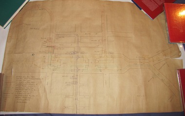
Drawing, Electric Supply Co. of Vic (ESCo), Tramway Power supply arrangements 1914, Jan. 2014
Yields information about the electrical power supply and overhead switching for Ballarat in 1914.Rolled drawing showing Tramway Power supply arrangements 1914, track map, power station, feeder cable, switches, section insulators, box locations, lightning arrestors and feeder cables for the various routes in Ballarat. Dated 2/1/1914, with initials GL. The various cables and trolley wire has been drawing in differing colours.ballarat, power station, overhead, section insulators -
 Otway Districts Historical Society
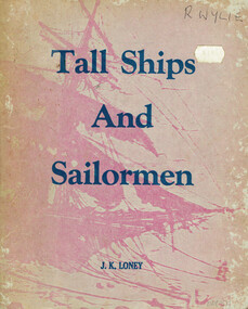
Book, J.K. Loney, Tall ships and sailormen
Compiled from newspapers, official records, registers, books and unpublished diaries Tall ships and sailormen provides information for those interested in the marine history of Victoria.Tall ships and sailormen. A concise survey of Victoria's early maritime history. J.K. Loney. nl; J.K. Loney; nd. ii, 103 p.; illus, maps, bibliography. Soft cover. ISBN 0 909244 02 2victoria; ships; sailors; j.k. loney; history; -
 Otway Districts Historical Society
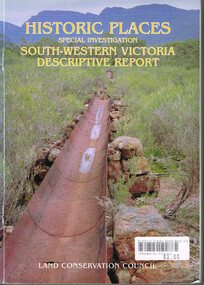
Book, Land Conservation Council, Historic places: Special investigation: South-Western Victoria: Descriptive report, January 1996
The south-west of Victoria, possessing a rich heritage of the signs of past human activity, is fertile ground for an investigation of historic places on public land. This report includes an initial inventory of almost 2000 places. The report outlines the history and the related heritage of the area, describes in some detail its biophysical attributes and introduces the natural resources and present land use. This information provides a context for understanding the origins of the historical features that are observes today.Historic places: Special investigation: South-Western Victoria: Descriptive report. Land Conservation Council. Land Conservation Council; Melbourne (Vic); January 1966. viii, 180 p.; illus.; maps. Soft cover. ISBN 0 7241 9288 3Maps in plastic sleeve.land conservation council; conservation; south-western victoria; historic places; -
 Otway Districts Historical Society
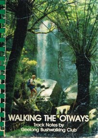
Book, Geelong Bushwalking Club Inc, Walking the Otways, November 1986
The Otways area of Victoria, at the time of writing, was an underused area for bushwalking. In the past, people have considered these ranges unsuited for walking because of the thick forest cover, cold and muddy conditions for much of the year, and the steep slopes. Some of the perceived difficulties are actually attractions and that it is possible to enjoy them with a forward planning and up-to-date information to guide the walker.The Geelong Bushwalking Club have included some useful but brief articles on basic aspects of bushwalking.Walking the Otways. Track notes compiled by the Geelong Bushwalking Club. Graeme Allen (ed.); John Van Gemert (maps, photographs). 1st ed. Geelong Bushwalking Club; Geelong (Vic); November 1986. 148 p.; illus, maps. Soft cover.otways; bushwalking; -
 Bendigo Historical Society Inc.
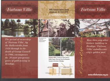
Document - FORTUNA COLLECTION: FORTUNA VILLA
Coloured tri-fold brochure titled Fortuna Villa. There are several coloured photos of the Villa and garden, a short history, information on the Villa Fortuna Action Group and their ideas for its future use. There is also a printed membership form. A small location map is included.bendigo, clubs, fortuna villa, christopher ballerstedt, theodore ballerstedt, 180 mine, george lansell, edith lansell, william beebe, vahland, getzschmann, emil maumann, commonwealth department of defence, the fortuna villa action group, city of greater bendigo, julian prowd, geoff hocking, bart-n-print -
 Bendigo Historical Society Inc.
Book - Geographical dictionary
The Gazetteer presents an extensive a to z list of Victorian towns and villages, lakes, rivers and creeks, islands, bays, hills and mountains, runs and other localities and features. Entries include latitude and longitude, populations, proximity to other towns, local industries, coach and mail runs, hotels, churches and schools.Bailliere's Victorian Gazetteer and road guide containing the most recent and accurate information as to every place in the colony. Brown hardcover book, on the spine: Victorian Gazetteer with map 1865. The first and last pages are advertisements. The book has 442 pages listing every place in the colony. The map is not included. Compiled by Robert P. Whitworth. Published by Bailliere, Regent Street Unreadable name on first page and the name of F. Houston in blue pen on first page geographic dictionary, colony of victoria -
 Bendigo Historical Society Inc.
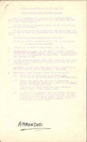
Document - PETER ELLIS COLLECTION: A GUIDE FOR DRIVERS ON THE WHIPSTICK TOUR
A Guide for Drivers on the Whipstick Tour. First page gives assembly area, driving in convoy and negotiating water or boggy patches across the road. Amended written at the end of the page. Directions with mileage and items of interest for the tour on Sunday September 9th (no year). A Whipstick Map 1971 showing State Forest, Crown Lands, Uncleared Mallee - Private (shown in different colours) Water Reserve and Roads. Noted are Flora and Fauna - Plants, Birds & Mammals, and areas of State Forest and Southern State Forest with Mallee Scrub area noted. Also State Forest & Crown Lands Total Area and a map scale. The Bendigo Whipstick mentions area, suggestions of where the name Whipstick came from, shrubs and flowers with their flowering times, descriptions of some of them and some information on the Mallee Fowl. The Eucalyptus Oil Industry paragraph mentions the beginnings of the industry. Mentioned are the different uses of oils (perfumery, industrial and medicinal) and the different species of eucalypt used for each and various products. Also notes on the growing, harvesting and refining of eucalyptus. P Ellis at the end of the page. The next two and a half pages mentions reserves, and at the end acknowledgements. Includes a spare copy of 'The Bendigo Whipstick' by P Ellis.bendigo, history, early bendigo, peter ellis collection, a guide for drivers on the whipstick tour, the whipstick 1971 map, shire of marong, shire of east loddon, shire of huntly, borough of eaglehawk, city of bendigo, shire of strathfieldsaye, the bendigo whipstick, eucalyptus oil industry, eaglehawk town hall, lightning hill lookout, eaglehawk rifle range, new moon mines, blue jacket reservoir, maggetti's wine hall, camp hotel (ex), skylark dam, eucalyptus oil production, eucalyptus factory, whipstick eucalyptus farm, ruedin's eucalyptus factory, dutch bowls, governor philip, sir joseph banks, john white, baron von mueller, joseph bosisto, commonwealth government, perfumery oils, industrial oils, medicinal oils, p ellis, dr frith, csiro wildlife division, harley webster, forests commission, vincent serventy, victorian national parks association, bendigo field naturalists club -
 Bendigo Historical Society Inc.
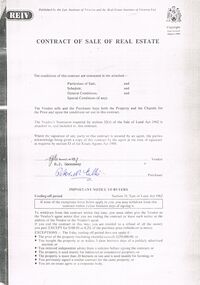
Document - PETER ELLIS COLLECTION: CONTRACT OF SALE
Copy of Contract of Sale of Real Estate and associated papers for property located in Flora Lane, Flora Hill which was purchased by Peter Ellis on 26 May 1993. Contract is in booklet with other loose papers. Contract includes General Conditions, Particulars of Sale, Special Conditions, Guarantee, Vendors Statement to the Purchaser, Shire of Strathfieldsaye Land Information Certificate, Planning Certificate Request for Building Approval Particulars, Coliban Region Water Authority Information Statement, Property Inquiry Application Form, Request for Property Information from Vic roads, Advice on Mine Subsidence Hazard (Department of Energy & Minerals), Map, Copy of Certificate of Title and Folder Numbers. Loose pages include Building Control Act 1981 Inspection Notice, two plans of building, Three plans (Coliban Water Asset Location) of Flora Lane where property is situated, 2 dated 13/11/2007 (have New Carport drawn beside house) and 1 dated 22/11/2007. Last page has specifications for car port.bendigo, house, peter ellis oam, peter ellis collection, reiv, law institute of victoria, real estate institute of victoria ltd, e j gannaway, peter n ellis, ray white bendigo pty ltd, e m monotti & son, rogers and every, craig watts, shire of strathfieldsaye, coliban region water authority, sec, g & fc of vic, telecom, vicroads, bruce l phillips, k deps?, department of energy and minerals, robert james sanderson, t flanagan, land titles office victoria, harston partridge & co pty ltd -
 Bendigo Historical Society Inc.
Document - MERLE BUSH COLLECTION: VARIOUS DOCS
Various docs (possibly from Bush Collection?) a. Public issue of State Electricity Commission securities - letter to Stockholders; Power Loans ; Cash and Conversion Loans 1954/55; b. Board of Works Cash Loan Prospectus 1956; c. Card with information re the MMBW Metropolitan Farm; d. two B&W interior photos of St. Davids church, Hobart; e. J C Williamson Magazine programme 1934; f. Melbourne & Metropolitan Tramways Board -map of proposals for General Scheme 1923.ephemera, mementoes, general interest -
 Bendigo Historical Society Inc.
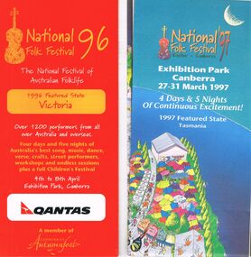
Document - PETER ELLIS COLLECTION: NATIONAL FOLK FESTIVAL, 3rd February, 1996
Collection of National Folk Festival programs and literature. Programs from the years 1995, 1996 and 1998. All have colourful covers and contains General Information, information on performers, programs, site maps, some photos of performers and some health information. Some pamphlets include a Ticket Order Form and a larger National Folk Festival 97 where the featured state is Tasmania. Letter to John Williams from Phil Wilson, Director National Folk Festival, dated 3 February 1996 confirming performance and ticket details for Emu Creek Bush Band CD Launch.entertainment, music, national folk festival, peter ellis collection, emu creek bush band, peter ellis -
 Bendigo Historical Society Inc.
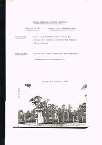
Document - GERMAN HERITAGE SOCIETY COLLECTION: TATURA DISTRICT 1939-1947, Sunday 14th November 1993
Compiled reference articles on the Tatura District, 1939-1947. Information from War Museum Archives, Canberra. File 780/1 (2 pages). Tatura and the Shire of Rodney, by W H Bossence. Walls of Wire, Tatura Rushworth Murchison by Joyce Hammond. The Story of the Beilharz Family by Dr. Paul Sauer. Contains a map, with Internment Camps, of the Shire of Rodney, Prisoners of War in Australia During World War 2, Special Requirements for Internees : Accommodation. Chap. 1, Prisoner of War and Internment Camps at Tatura, Vic., Plan of the Camp. Has a pale yellow front cover and a pale blue back cover.document, memo, german heritage society, german heritage society collection - visit to tatura, german heritage society bendigo, german war cemetry, war museum archives canberra, tatura and the shire of rodney, walls of wire tatura rushworth murchison, the story of the beilharz family, ian walder, geoff pedersen, kurt beilharz -
 Ballarat Tramway Museum
Pamphlet - advertising the Museum, Ballarat Tramway Preservation Society (BTPS), 1975
Pamphlet advertising the Museum, with a sketch of tram 40, with the name "Ballarat Tourist Tramway" on the rear and giving visiting details and fares. Has a map on the rear showing the location and track along Wendouee Parade. See item 6296 for an earlier example. Yields information about BTPS Marketing c1975.Duplicated quarto sheet two sided on white paper.tramways, ballarat, btps, map, drawings, sketches, fares, operations -
 Ballarat Tramway Museum
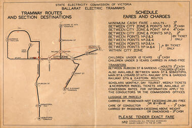
Poster, State Electricity Commission of Victoria (SECV), "Schedule of Fares and Charges", 1937
Shows Ballarat Tramway (SEC) Fares, Charges, and Section Map. Also gives charges for the various sections, transfers, luggage of parcels, age of children. All fares in pence. In particular note the 1d fares for Sebastopol Post Office and the City Zone. See item 8025 for a the printed explanation of the new fare system introduced by the SEC in Ballarat from Sunday 3/10/1937,Demonstrates the work the SEC undertook to provide information on the new ticket system of 1937 and yields information about the system.Poster - printed on manila card in black ink.Numerous pencil and red colour pencil markings.tramways, sec, fares, sections, tickets -
 Ballarat Tramway Museum
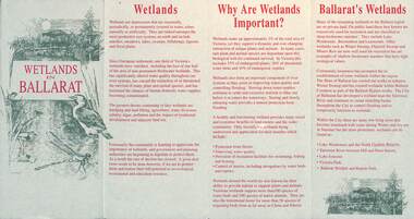
Pamphlet, City of Ballarat, "Wetlands in Ballarat", early 1990s
The pamphlet provides information about the wetland areas in the Ballarat district, in particular the ones in the North Gardens Reserve and Lake Wendouree. Provides information on the importance of the Wetlands, locations and a map. As well, provides contact details for the Department of Conservation and Natural Resources and the City of Ballaarat. Based on the spelling of the City of Ballaarat pamphlet early 1990s.Yields information about the Ballarat's wetlands within in which the tramway museum operates.Pamphlet - 4 fold DL printed in red and green ink.city of ballarat, wetlands, lake wendouree, conservation