Showing 981 items
matching paddocks
-
 Wodonga & District Historical Society Inc
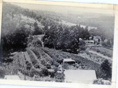
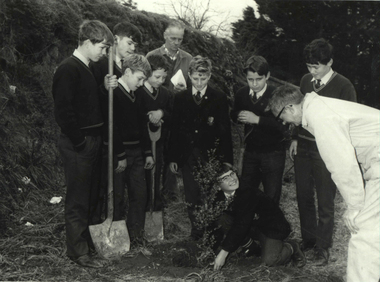
Album - Ringer's River by Des Martin - Plate 2 - MacLough sacks Neilson as manager of "Gooloora"
MacLough surprises Neilson, erstwile manager of "Gooloora", breakfasting off a bottle of whisky and a cup of black tea, and sacks him on the spot. Ordering the hands to be called together he looks them over and queries the absence of young O'Day. Jackeroo Reg Apperton tells him O'Day is out mending a fence at the back of the stud paddock, and MacLough commands that Apperton drive him out there forthwith. D. Hartsman as Neilson.The album and images are significant because they document literature written by a prominent member of the Wodonga community. The presentation of this precis was supported by several significant district families and individuals.Ringer's River Album Coloured photo Plate 2des martin, many a mile, ringer's river, northeast victoria stories -
 Federation University Historical Collection
Photograph, Ballarat Junior Technical School - outside the Ballarat Gaol Wall, c1921
In February 1913 the Ballarat Junior Technical School opened its doors to its 86 pupils. The old bluestone building in the grounds of the Dana Street Primary School became their temporary home for eight years. In its early years the school offered only a two-year course. The first year was of a general nature giving a thorough grounding in Mathematics and Instrumental Drawing, and introducing students to the various branches of trade work. The second-year students studied for the Junior Technical Certificate and specialized in a course of their choice - either a trade (Woodwork or Fitting and Turning) or a course leading to higher studies at the School of Mines. Increased enrolment - 86 to 110 in the second year. Some applicants were turned away due to lack of space. An abandoned single room school was brought in and this helped for a time. Plans were developed and a two-storied red brick building in the vacinity of the School of Mines was build. An acre of land was reclaimed from the north-east corner of the Ballarat Gaol. The school backed onto the wall of the gaol. The task of landscaping and terracing of the area was to cost a great deal and time. The boys did much of the heavy work. This kept them occupied as the official playground areas were still full of rubble.View from the south-east of the Junior Technical School with the slope from the gaol wall down to the area known as the Battery Paddock. The new school building was a two-storied red brick building along the Education Department style of the 1920s. On 9 September 1921, the Junior Technical School building was officially opened. Much work was needed to terrace and landscape the area. Students shown in various areas of the grounds.junior technical school, dana street primary school, bluestone, mathematics, instrumental drawing, junior technical certificate, woodwork, fitting and turning, school of mines, ballarat gaol, landscaping, terracing, gaol wall, cricket -
 University of Melbourne, Burnley Campus Archives
Photograph - Colour print, The Herald, The Harvest of Oats is Finished at the Burnley School of Horticulture and Primary Agriculture, 1935-1990
Photograph made by A.P. Winzenried for, "Green Grows Our Gardern," p73Colour photograph. Copy of newspaper article, made by A.P. Winzenried. Caption reads, "The harvest of oats is finished at the Burnley School of Horticulture and Agriculture, but these cheery girl harvesters will not be able to stack the crop until the weather improves. There are about 20 girl students at Burnley this year learning chiefly horticulture, but they are taught to grow and reap crops for fodder as well." 9 female students standing in a line holding forks in a paddock.Handwritten underneath, "Barbara Betty Herald Dec 1st/45."a.p. winzenried, green grows our garden, harvest, oats, burnley school of horticulture and agriculture, female students at burnley, barbara betty, students working outside, forks -
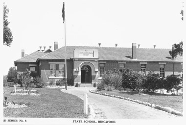
 Ringwood and District Historical Society
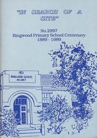
Booklet - Book, In Search of a Site, 1989
History of the Ringwood Primary School No 2997 from 1889 to 1989 Contents include List of Head Teachers/Principals, Finding a Site, Time Line, Reminiscences of Miss Daisy Paddock, Anecdotes From Former Pupils. Acknowledgement - In researching the history of Ringwood Primary School, we would like to acknowledge the valuable information obtained from the History of Ringwood Primary School compiled by Mr. J.A. Baines. -
 Ringwood and District Historical Society
Archive, Ringwood Primary School Collection of scrapbooks, photos, literature, class photos etc. 1940-1997 (Parent Record)
Ringwood Primary School - Albums of history and school photos from the laying of foundation stone in 1921Collection of nine A3 scrap books documenting Ringwood Primary School, with photos from pre 1940 to 1983 with coloured covers and plastic spines plus one Junior Teachers record book; Ringwood Primary School - Literature and photos pre 1940; Ringwood Primary School - School photos 1940s; Ringwood Primary School - Photos and Literature 1940s and 1950s; Ringwood Primary School - School photos 1950s; Ringwood Primary School - School photos 1970 to 1974; Ringwood Primary School - School photos 1975 to 1979; Ringwood Primary School - School photos 1980 to 1983; Ringwood Primary School - School photos 1983 to 1997 ; Ringwood Primary School - Literature and photos relating to the library and Miss Paddock; Education Department Junior Teachers Record Book for Ringwood Primary School 2997 from 1932 to 1942 +Additional Keywords: Paddock, Janet (Daisy) -
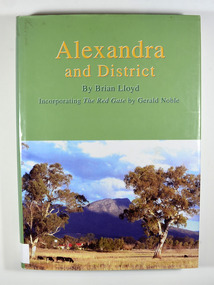 Marysville & District Historical Society
Book, Alexandra and District, 2006
A history of Alexandra and surroundsHardback. Front cover has a photograph of a farmhouse in a paddock with Cathedral Mountain in the background. Back cover has a circular emblem that has a miner digging, a pump house and poppet head and some bales of wool. The words 'Founded on gold wool and butter' surround the centre. There is also a photograph of the main street of old Alexandra with a stagecoach drawn by two horses that has three people seated in and on the stagecoach along with some luggage on the roof.Stamp of the Marysville & District Historical Society Inc / P.O. Box 22 / Marysville 3779alexandra region-victoria, history -
 Kiewa Valley Historical Society
Photos: Bogong Hotel and Kiewa Valley
The Bogong Pub was a central point for social gatherings in the Kiewa Valley.Black and white photos framed with thick brown cardboard that is framed by two rows of lines around the photo thus forming a frame. The cardboard is folded in half to form a 'card' enabling the photo to stand. 1. People standing outside the Bogong Pub. The pub is behind trees. Two old/vintage cars are partially in the photo. 2.The Kiewa Valley showing paddocks, trees lining the Kiewa River and mountains in the background.bogong pub, kiewa valley -
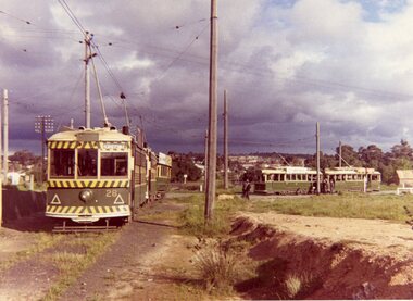
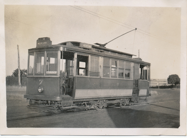 Ballarat Tramway Museum
Photograph - Black & White Photograph/s, Wal Jack, 3/03/1940 12:00:00 AM
Black and White print contained within the Wal Jack Bendigo and Geelong Album, see Reg Item 5003 for more details. Photo of Geelong No. 7 at the East terminus. The tram has the destination of Chilwell. In the background are paddocks. Photo by Wal Jack 3/3/1940. Printed on Kodak paper. i1 - scan of print in the album i2 - rear of image i3 - scan of negative at 3200dpi added 6/6/2020. On rear in ink "T140 Geelong Tramways No. 7 Brush Saloon, East terminus 3-3-40. W Jack photo"trams, tramways, geelong, east, tram 7 -
 Southern Sherbrooke Historical Society Inc.
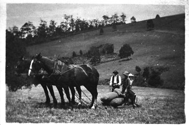
Photograph - Bringing in potatoes at Glen Park Farm, Selby, c.1913
B&W photo shows a two-horse team harnessed to a small sled which is laden with bagged-up potatoes. A man wearing dark hat, waistcoat and trousers and a pale shirt is holding the reins of the horses, and two people who could be the Johns children, Percy and Cissie, are seated on the potatoes. The paddock slopes away and another hillside rises in the background. This is most likely Black Hill. dated c.1913. -
 Kew Historical Society Inc
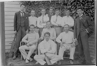
Photograph, First XI, Kew Cricket Club, 1913
The first cricket club in Kew in was formed in 1863, and played its matches in Wellington Street, and then later in O’Shaughnessy’s Paddock. In the early 1870s, a second club was formed and played at Victoria Park. The Kew Cricket Club gained its permanent name in 1888-89. One of the named players in the photograph - Albert Watson - was the son of the local Methodist Minister. The photograph entered the collection within a donation of items by Mrs Joy Ivory, a descendant of the Watson family, and a member of the Society.The photograph, dating from 1911 has local significance as an image of participation in sport and recreation.A monochrome photograph, mounted on card of the Kew Cricket Club's first XI cricket team in 1911. Annotations on the reverse identify three of the players: Standing left with bat: George Twycross; standing right: Albert Clements; Seated third on right: Albert Watson.Presented to Kew Historical by Mrs Ivory (nee Watson) Kew Cricket Club / Standing left with the bat Mr George Twycross / Standing right Mr Bert Clements / Seated third on right Mr Albert Watson / Year 1913kew cricket club (vic), sport - kew - victoria, albert watson, albert clements, george twycross -
 Bacchus Marsh & District Historical Society
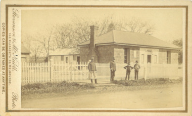
Photograph, Police Barracks Main Street Bacchus Marsh 1883
The Bacchus Marsh Police Barracks shown in this image were located in Main Street on the site of the present day Police Station. The Barracks were constructed around 1857 or 1858. Prior to this the Police were stationed in the Police Paddocks at Maddingley in the area where Maddingley Park is now located. This building was in use by the Police until 1930 when it was replaced by a new building. This later building was in use until the early 2000s but was demolished in 2003 and replaced by a larger Police building.Small sepia unframed photograph on card with gold border framing photograph. Housed in the album, 'Photographs of Bacchus Marsh and District in 1883 by Stevenson and McNicoll'. The image shows the Bacchus Marsh Police Police Barracks and stables in 1883. Two uniformed male police officers wearing helmets can be seen standing on the footpath in front of the building. Next to them on their left appear to be two boys. The Barracks is a sandstone building with a chimney on one side and appears to have a slate roof.On the front: Stevenson & McNicoll. Photo. 108 Elizabeth St. Melbourne. COPIES CAN BE OBTAINED AT ANY TIME. On the back: LIGHT & TRUTH inscribed on a banner surmounted by a representation of the rising sun. Copies of this Portrait can be had at any time by sending the Name and Post Office Money Order or Stamps for the amount of order to STEVENSON & McNICOLL LATE BENSON & STEVENSON, Photographers. 108 Elizabeth Street, MELBOURNE. stevenson and mcnicoll 1883 photographs of bacchus marsh and district, bacchus marsh police station, police stations, police -
 Mt Dandenong & District Historical Society Inc.
Photograph, View From Corner of Doughty's Road and Barbers Road 1913
John Lundy-Clarke grew up in the Kalorama/Mt Dandenong area and later in life (1972-74) began to write a comprehensive history of the area working from an original settlement map in an effort to cover all areas. Taken c1913, this photograph gives a clear indication of where significant buildings were located in relation to one another. Barbers Road is running through the picture with the guest house 'Kia-Ora' , built by George Barber in the centre. High on the skyline on the left is the 'Mountjoy' guesthouse, indicating the location of The Gap, or FiveWays. The small 'boxy' house above 'Kia-Ora' is 'Iona' built by the Paynter family who also built 'Mountjoy'. The Jeeves property 'Kalorama' is to the right of 'Iona' and this is the area you now look to from the FiveWays Lookout. The man in the photo is wearing a trilby hat so is probably a Rose Series employee - a feature in many Rose Series postcards.Black and white photograph that is a copy of Rose Series Postcard # 156. A man can be seen walking down an unmade road with haystacks to his right. Buildings and crops can be seen on the hillsides. Handwritten inscription on reverse by John Lundy-ClarkeView from corner of Doughty’s and Barbers Road 1913. “Kia Ora” in centre Paynter’s “Iona” near center skyline above “Kia Ora” with “Kalorama” on its right and Peter’s hut of the time below it among orchard trees. “Mountjoy” is on left skyline. W. Haye’s home is centre left. Hay paddock is Barbers Lot 25 Village Settlement.kia-ora, iona, kalorama, mountjoy, guesthouse, guest house, barbers road, doughty's road, paynter, jeeves, george barber -
 Mt Dandenong & District Historical Society Inc.
Photograph, 1913 View Over Logan's House in Village Settlement, 1913
Photograph taken in 1913 from Barbers Road showing the view down the valley. Roof in foreground is house on Bob Logan's Lot 28 in the Village Settlement. This photograph has a detailed inscription on the back handwritten by John Lundy-Clarke in 1974.1913 view over Logan’s house on Village Settlement Lot 28 taken from Barber’s Road. This is the house that the runaway log leaped over in 1930 to land far down the orchard row beyond the house. “Shiloah” is centre partly behind the clump of trees and the paddocks of Child and Richardsons pioneer selections are in the background. Link Road is centre right.logan, bob logan, robert logan, barbers road, shiloah, child, richardson, link road -
 Flagstaff Hill Maritime Museum and Village
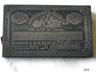
Currency - Engravers Plate, Five-pound, 15-02-1900
This banknote plate was created for the Sydney branch of the Bank of Australasia in February 1900, before the Federation of Australia. After printing the banknotes from this plate the printer would have overprinted the banknotes with a unique serial number and the denomination of the banknote in capital letters using a contrasting ink. The Bank of Australasia was incorporated by Royal Charter of England in March 1834. It first came to Australia on 14th December 1835, opening in Sydney. In that year, the Acting Superintendent of the Bank of Australasia in Sydney was David Charters McArthur. He went on to become the Superintendent from 1867-to 1876. The Melbourne branch of the Bank of Australasia opened on 28th August 1838. In 1951 the Bank of Australasia amalgamated with the Union Bank to form the Australia and New Zealand Bank, now known as the ANZ. Then in 1970 the ANZ merged with both the ES&A and the London Bank of Australia to form the ANZ Banking Group Limited. The ANZ Banking Group Ltd kindly donated a variety of historic items from the Bank of Australasia. BANK of AUSTRALASIA, WARRNAMBOOL – The Bank of Australasia was the first bank in Warrnambool. It was established in 1854 and operated from leased buildings on Merri Street and then Timor Street. The bank opened its own building on May 21, 1860, on the northeast corner of Timor and Kepler Streets. Mr A Butt was the Manager of the Warrnambool Branch in 1895. This significant item of early Australian social history gives a snapshot into the founding and early development of the banking system in Australia. The plate has historical significance as it belonged to the Bank of Australasia which was established in 1834 by Royal Charter and opened in Sydney, Australia, in Sydney in 1835. The plate is significant for its association with the Bank of Australasia, which had a branch in Warrnambool. Warrnambool's branch was the first bank in Warrnambool, established in 1854. The bank continued to operate until its merger in 1951 when it became the ANZ Bank, which is still in operation today. The Bank was an integral part of the establishment and growth of commerce in Colonial Warrnambool and throughout Australia.Printer's plate for a five-pound note, attached to a block comprising several layers of different varieties of wood. Rectangular metal plate embossed with the banknote's design and produced by the Sydney, New South Wales, branch of the Bank of Australasia. The border includes numbers and text. The image of the bank's logo is included, along with the banknote's denomination in letters and numerals, a signature and a date of 15th February 1900.On the border: in each corner "5", on sides and base "NEW SOUTH WALES" Within the border "FIVE" "The Bank of Australasia / INCORPORATED BY ROYAL CHARTER IN 1835" "FIVE POUNDS' "SYDNEY 5th of February 1900" "for the Bank of Australasia" (Signature) , "MANAGER" Image: (Bank's logo) [Two female figures seated together in a paddock, produce beside them, sheep and buildings in the background]flagstaff hill, warrnambool, shipwrecked coast, flagstaff hill maritime museum, maritime museum, shipwreck coast, flagstaff hill maritime village, great ocean road, bank of australasia, union bank, australia & new zealand bank, anz bank, sydney, new south wales, currency, banknote, legal tender, commerce, banking, five-pound note, banknote plate, printing plate -
 Orbost & District Historical Society
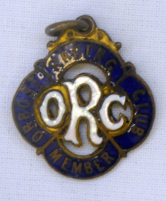
badge, 1890's
This is a member's badge for the Orbost Racing Club and belonged to Mat Lynch. Secretary was Mr W. A. Malcolm. Some of the earliest horse races were held on a course in a paddock belonging to Mr James Cowell at Jarrahmond. For a long time horse races were part of the Marlo Picnic Races. Bellagoogan on Majors Creek near Orbost was the site of the first race course. Mat Lynch was a prominent local identity and generously donated a block of land situated on the Princes Highway, for the Brodribb Hall.Horse racing played a vital role in the history of Orbost. This item is connected to that role.A small metal badge which is a diamond shape with rounded corners. It has a small metal loop at the top. In gold print is "Member Orbost Racing Club" on a dark blue enamel around the edge. In the centre is "ORC" in white enamel.On back - 28 - LYNCH - almost indecipherable.orbost-racing-club lynch-mat recreation horse-racing -
 Orbost & District Historical Society
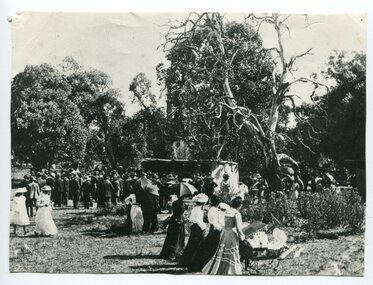
black and white photograph, C1890
This photo shows people at the running of the Orbost Cup in 1890s. The Orbost Race Club was founded in 1890. Many early members were: George Morgan, James Cowell, J. Farquhar, J. Cameron, L. Herbert, S. J. Lynn, Arch. Rodwell, J. Ashby, A. W. McLeod, W. Middleton, W. Archer, J. Pleydell and J. Drew. The races were conducted on a course laid out in a paddock of Mr James Cowell at Jarrahmond. (info. from Newsletter HISTORY OF ORBOST) This item is associated with horse racing in early Orbost.A black / white photograph of a large group of men, women and children at an outing in a bush setting with a large flat area. They appear to be watching an event. Many of the women are holding opened large umbrellas. It is on a grey buff card.horse-racing-orbost orbost-race-club -
 Ballarat Heritage Services
Photograph - Photograph - Colour, Clare Gervasoni, Carisbrook Police Lockup, c1998
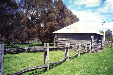
The Carisbrook Police Lockup, originally known as the Loddon Punt, was opened in 1851. At that time it was part of the Castlemaine Police District. Standing in the park beside Bucknall Street it is the town's one significant historic building. It was originally built on the police paddock adjacent to the primary school and moved to its present site in 1886. The walls are made of interlocking horizontally-laid logs. The shingle roof has been replaced with corrugated iron. The lockup was registered by the National Trust on 22/10/1964.Colour photograph of a log building known as the Carisbrook Police Lockup.carisbrook, carisbrook lockup, carisbrook police lockup, log cabin, police, police paddock -
 Whitehorse Historical Society Inc.
Photograph, 443 Mitcham Road, Mitcham, 1998
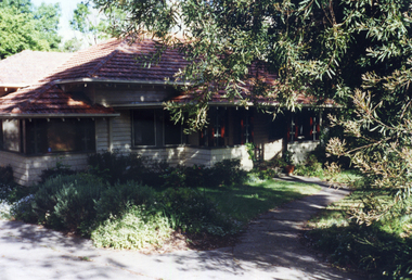
Eric Roger Webb moved to Mitcham with his family in about 1932. They lived at 443 Mitcham Road and owned all the land up to Simpson Street. The land was a grass paddock and he planted native trees and shrubs around the perimeter. The Webbs has three children: Eric, Dean and Donald. Mr Webb worked in the public service. He was a councillor of the Shire of Blackburn and Mitcham and later of the city of Nunawading between 1940 and 1949. He was also a Shire President from 1943-1944.Coloured photograph of a house at 443 Mitcham Road, Mitcham. Tiled roof, verandah, path leading to front door.443 mitcham road, mitcham, houses, webb, eric -
 Eltham District Historical Society Inc
Photograph - Photograph postcard, A peep at the picnickers, Eltham, c.1904
Postcards scanned from the collection of Michael Aitken on loan to EDHS, 13 Feb 2018 Reproduced ‘Pioneers & Painters’ pp 52-53. Picnickers enjoying a Sunday outing in the fields opposite Eltham Railway Station. Looking north towards Research along Main Road near the intersection with Dudley Street. Luther Hayley’s Bakery and General Store on left promoting refreshments and summer drinks. With the opening of the railway to Eltham in 1902, Melbourne residents would regularly enjoy a Sunday excursion journey on the train to Eltham for a day’s outing to the countryside. Possibly the annual State schools picnic held by the Board of Advice at Haley's Paddock near Eltham railway station on 11 March, 1904. Haley’s Paddock (now occupied by Eltham shopping centre) was capable of accommodating 10,000 people, with ample shade and hilly surroundings, an ideal place for any gathering. The main foreground is the site of the present day Eltham Village and Coles Shopping Centre. 1904 'STATE SCHOOLS' PICNIC.', Record (Emerald Hill, Vic. : 1881 - 1954), 19 March, p. 3. http://nla.gov.au/nla.news-article165173087Digital file only Postcards scanned from the collection of Michael Aitken on loan to EDHS, 13 Feb 2018michael aitken collection, postcards, eltham, main road, bakery, eltham village reserve, general store, haley's paddock, luther haley, luther haley general store, picnic, pioneers and painters, railway store, shire of eltham pioneers photograph collection, summer drinks -
 University of Melbourne, Burnley Campus Archives
Plan, Royal Horticultural Society's Garden
Changed boundaries of the site burnley gardens, survey paddock, flood, lynch design, richmond park, yarra river -
 University of Melbourne, Burnley Campus Archives
Newspaper - Newspaper Cutting, Down on the farm - at Burnley, 1931
(1) Two students sitting on straw and holding a bucket. (2) Seven female students with a horse and cart. One student is sitting on the horse and the caption reads: "New recruits at Burnley Horticultural School drove in rustic state to gather the maize crop yesterday. So popular has the school course become that there are no more vacancies for students this season. These beginners tackled a tall job, for the maize produced in the school paddock is 10 to 11 feet high."students, female students, burnley horticultural college, maize, students working outside, horses -
 Ballarat Tramway Museum
Photograph - Colour Photograph/s, B. Groves?, 7/12/1962 12:00:00 AM
Colour print of five SECV Bendigo trams at the North Bendigo tram terminus during a 1962 tour. Tram 28 (Birney), another Birney and then three single truckers at the terminus. All have their poles turned to return to the City. Photo shows the nature of the location of the terminus; open paddocks. All trams have been fitted with dash canopy lights. Taken on AGFA paper. On rear is a stamped date "- 7.12.62", looks like a machine imprint.On rear "Tram Tour Bendigo / Mr. B. Groves / 333 Pascoe Vale Road / Essendon W5 / Vict." In top right hand corner is the number "1175" In the stamp appears " 110B / Photo / The? / -7.12.62"birney, bendigo, north bendigo, tram 28 -
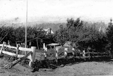 Southern Sherbrooke Historical Society Inc.
Photograph - Tantallon, Douglas farm at Menzies Creek/Emerald
Black and White photograph of 'Tantallon', the Menzies Creek/Emerald Farm owned by Norah and Percy Douglas, situated on the north side of Ridge Road. The photo shows a corner of a post and rail fence enclosing a small farm paddock. Behind a row of trees, a brick chimney and part of a roof can be seen, presumably the main farmhouse. Timbered hills can be seen in the background. The photo appears to be taken looking north. See also VSSH0046 for more details. -
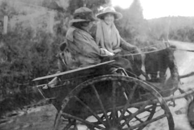 Southern Sherbrooke Historical Society Inc.
Photograph - Photo, Norah Douglas
Black and White photograph of Mrs Norah Douglas (1864-1957) and an unidentified woman seated on a trap on a road winding between hills. Forest and paddocks are visible. Both women are wearing winter coats and hats with brims. One woman is facing away from the camera. The other woman is facing the camera and is smiling either at the photographer or her companion. The second woman has a heavy scarf or shawl around her neck. See VSSH0046 for further information on the family. -
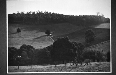 Southern Sherbrooke Historical Society Inc.
Photograph - Glen Park Farm, Selby
B&W photo showing Glen Park Farm, Selby, owned by the Johns family, as seen from the north-east corner. Photo shows the descent to the valley then up Black Hill in the background. Mostly cleared paddock apart from the cypress avenue to the farmhouse (which is glimpsed between the trees) a few single trees dotted about, and the heavily treed area on the top of Black Hill. There is a small building or shed or possibly a haystack in the centre of the photo. -
 Federation University Historical Collection
Photograph - Photograph - Black and White, Ballarat Technical School Students Plant Out Old Gaol Terraces, 1969, 14/07/1969
When Ballarat Junior Technical School's new building was opened in 1921, the surrounding area was rubble-strewn with raw clay slopes. The Head, A W Steane designed the landscaping of the slopes from the Gaol wall down to the Battery Paddock. The boys did much of the work. Apart from beautifying the grounds, this project occupied their leisure time, particularly as they had nowhere to play. The school acquired the gaol site in April 1969. The work of improving the grounds which was begun by A W Steane and his students is being carried on.Eight Form 1 boys from Ballarat Technical School planting trees at the old Ballarat Gaol terraces. Don Ogilvie is in the foreground. Peter Murley is planting watched by Frank McKenzie in the background. Boys from left: John Brown, Bradley Julius, Gary Green, Steven Ryan, Kim Hall, Peter Gross, Peter Rasmussen.Details of photograph written in pencil on back "Ballarat Courier Press Photograph - Copyright - " stamped on back.ballarat junior technical school, grant street garden, garden terrace, ballarat gaol, battery paddock, former ballarat gaol walls, don ogilvie, john brown, bradley julius, gary green, steven ryan, kim hall, peter gross, peter rasmussen., peter murley, frank mckenzie, ballarat technical school -
 St Kilda Historical Society
Photograph
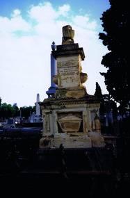
The Melbourne General Cemetery opened in June 1853. The first male buried there was John Alexander Burnett, chief clerk to the mercantile firm of Dalgety, Borradale & Co. The headstone reads: In Memory of James Alexander Burnett, Merchant, Who Died 25 May 1853, Aged 36 Years. Burnett Street, St Kilda, is named after him. The street was created by F. G. Dalgety when he sold his land in St Kilda (12 acres known as 'Dalgety's Paddock') on 12 April 1853.Colour photographIst Grave in Melbourne Cemetery of St Kilda identity John Alexander Burnettst kilda, john alexander burnett, melbourne cemetery -
 Eltham District Historical Society Inc
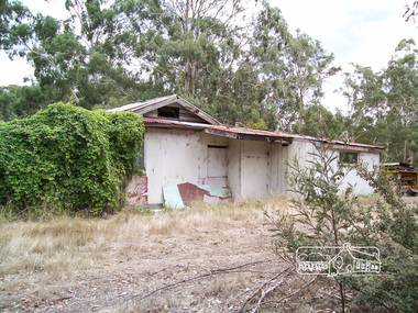
Photograph, Richard Pinn, Wattle Glen Picnic Ground, Dilapidated Pavilion Building, 2015, 07/02/2015
The Wattle Glen Picnic Ground was located in a paddock just west of the Wattle Glen railway station (between the station and the creek). It has now completely disappeared except for a dilapidated overgrown building on a rise across the track from the railway platform. This was the picnic ground's main pavilion, which for a short time (circa 1972-1974) also served as the Wattle Glen post office and general store. The picnic ground operated from circa 1925 until late 1974, its heyday being in the early 1970s.Born digital (three images)wattle glen, picnic ground -
 Eltham District Historical Society Inc
Photograph - Digital Photograph, Marguerite Marshall, Hawthorn hedges, Eltham-Yarra Glen Road, Kangaroo Ground, 3 October 2006
Hawthorn hedges are important reminders of Kangaroo Ground's Scottish heritage. They are Registered on the Victorian Heritage Register. They are "historically significant because the planting of hawthorn hedges reflects the adoption of Eurorpean farming techniques by the Kangaroo Ground population in the period following settlement and because the grid pattern of paddocks that the Hawthorn hedges define is very different to today's farm landscapes." Covered under Heritage Overlay, Nillumbik Planning Scheme. Published: Nillumbik Now and Then / Marguerite Marshall 2008; photographs Alan King with Marguerite Marshall.; p21This collection of almost 130 photos about places and people within the Shire of Nillumbik, an urban and rural municipality in Melbourne's north, contributes to an understanding of the history of the Shire. Published in 2008 immediately prior to the Black Saturday bushfires of February 7, 2009, it documents sites that were impacted, and in some cases destroyed by the fires. It includes photographs taken especially for the publication, creating a unique time capsule representing the Shire in the early 21st century. It remains the most recent comprehenesive publication devoted to the Shire's history connecting local residents to the past. nillumbik now and then (marshall-king) collection, eltham-yarra glen road, hawthorn hedgerow, kangaroo ground -
 City of Greater Bendigo - Civic Collection
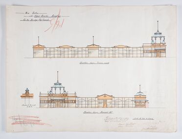
Work on paper - Architectural Drawing, City of Bendigo, New Baths at Upper Reserve Bendigo for the Bendigo City Council, 18th November 1912
The 'New' City of Bendigo baths also known as 'The Baths' were opened on 26th February,1913 at a cost of £2000. These baths made use of an existing dam and had men only and ladies bathing areas as well as a 'paddling paddock' for young children. This set of plans is for the Men's Bathing shed which serviced the men's bathing area adjacent to the still existing tennis courts on Barnard Street. In 1958 the Municipal Baths were replaced by an Olympic Pool and £17,000 was raised by public subscription towards this pool’s construction. Ink, pen, pencil and watercolour architectural drawing for the proposed new baths at the Upper Reserve on Barnard Street, Bendigo.New baths / at Upper Reserve Bendigo / for the Bendigo City Council / Elevation facing tennis courts / Elevation of Terminals at A, A, / Elevation facing Barnard Street / This is one of the drawings /referred to in my contract/ dated 18th November 1912 / Signed Robert J Rogers / (unknown) / Mayor Jas Semmensbendigo swimming club, rosalind park, upper reserve bendigo, faith leech memorial swimming pool, bendigo baths, city of greater bendigo community groups