Showing 3063 items matching "scales"
-
 Port Melbourne Historical & Preservation Society
Map - Melbourne and suburbs, MMBW, 8 Dec 1909
MMBW map of Melbourne and suburbs - Record plan up to July 1st 1913 (scale 3/4" = 1 mile)engineering - board of works, calder e oliver, russwaul(?) -
 Bendigo Historical Society Inc.
Map - JACK FLYNN COLLECTION: COUNTY OF GLADSTONE, 1934
Map: County of Gladstone, map sheet showing the whole of the County and the Parishes within. Scale 2 Miles to 1 inch.Engraved at the Department of Lands and Survey Melbourne. 1958. By Authority of W.M. Houston, Government Printermap, gladstone, parish plan, gladstone -
 Bendigo Historical Society Inc.
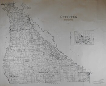
Map - JACK FLYNN COLLECTION: COUNTY OF GUNBOWER, 1935
Map; County of Gunbower. Sheet containing the whole of the County, showing parishes within. Scale 2 Miles to 1 inch.map, gunbower, parish plan, gunbower -
 Hepburn Shire Council Art and Heritage Collection
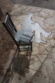
Public Art Work, Petrus Spronk, 'Memory of Place' - Petrus Spronk. 2000, 2005
Local Artist CV Artist StatementSignificant artwork by nationally renowned local artist Petrus Spronk.Large Scale Outdoor Sculpture made up of a bronze chair with an open book, a bronze shadow and 6 story rocksArtist signature - underneathlocal artist, petrus spronk, sculpture, public art, victoria, daylesford, mineral springs reserve, environmental art, hepburn shire public art collection, hepburn shire, hepburn springs, hepburn springs mineral reserve, bronze, granite, tourist attraction, art, clare gervasoni, joan mcewen, marie butler, laurie sullivan, bonnie howell, vera, lutea, merv keating, silent -
Stawell Historical Society Inc
Map, Crowlands & Navarre Railway Construction Trust, VR Plan Showing Railway Construction District Crowlands to navarre Line 1916, 4 July 1916
Two (2) Very large Coloured Maps. Scale 40 Chains to 1 Inch. rail Line Drawn in RedShire of Kara Kara. Shire of Stawell Shire of Ararat 4 July 1916railways -
Whitehorse Historical Society Inc.
Map, Mitcham Road, c1970
Enlarged aerial photo of the intersection of Mitcham and East Doncaster Roads, Mitcham. Scale 1 inch : 40 feet.Enlarged aerial photo, c1970, of the intersection of Mitcham and East Doncaster Roads, Mitcham. Scale 1 inch : 40 feet.Enlarged aerial photo of the intersection of Mitcham and East Doncaster Roads, Mitcham. Scale 1 inch : 40 feet.mitcham road, mitcham, quarry road, mitcham, doncaster east road, mitcham, wooddale grove, mitcham, mitcham primary school, no. 2904, aerial photographs -
Whitehorse Historical Society Inc.
Map, Sketch map, 1932
Sketch map of Doncaster, Mitcham and Tunstall. Scale 1 inch = 40 chains. 4th issue. 19 Apr 32Sketch map of Doncaster, Mitcham and Tunstall. Scale 1 inch = 40 chains. 4th issue. 19 Apr 32Sketch map of Doncaster, Mitcham and Tunstall. Scale 1 inch = 40 chains. 4th issue. 19 Apr 32maps, doncaster, mitcham, tunstall, nunawading -
Whitehorse Historical Society Inc.
Map, Legislative Assembly, 1984
State of Victoria Legislative Assembly electoral districts 1983 - 1984 redivision (Melbourne Metropolitan area) Scale 1:50,000State of Victoria Legislative Assembly electoral districts 1983 - 1984 redivision (Melbourne Metropolitan area) Scale 1:50,000State of Victoria Legislative Assembly electoral districts 1983 - 1984 redivision (Melbourne Metropolitan area) Scale 1:50,000victoria. parliament. legislative assembly, electoral boundaries -
Whitehorse Historical Society Inc.
Map, City of Nunawading, c1975
Map of City of Nunawading, showing location of 186 parks and reserves.Map of City of Nunawading, showing location of 186 parks and reserves. Scale 1:10,000 with list of streets and their map coordinates.Map of City of Nunawading, showing location of 186 parks and reserves. city of nunawading, parks and reserves -
 Australian Army Museum of Western Australia
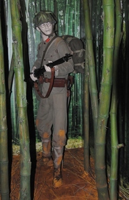
Diorama, 2015
This diorama is the introductory feature in the World War 2 Gallery - South West Pacific area. A private soldier is shown cautiously advancing down a jungle track outflanking Allied defensive positions1:1 scale diorama showing soldier of Imperial Japanese Army advancing through jungle in Malaya January 1942fall of singapore, 8th australian division -
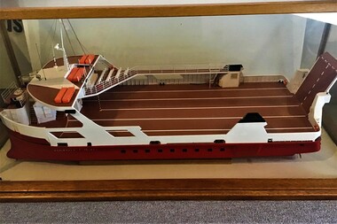
 Queenscliffe Maritime Museum
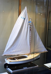
Model of Maud, 2012
Model of Maud made in 2012 by Malcolm Gibson in Geelong. Actual couta boat Maud was launched in 1927 built by Lars Halvorsen and now moored in QueenscliffMAUD is a wooden sailing vessel built in Victoria for fishing. It is an example of the Victorian couta boat class with a design adaptation for local conditions. It was built and designed by Peter Locke Jnr, at Queenscliff Victoria in 1931, with shallower draft than most couta boats so that it could operate from Barwon Heads. It is the only remaining couta boat from the Barwon Heads fleet.Scale model of Couta Boat Maud housed in a purpose built display case made by Showfront (owned by John Tiller)boat model, couta boat, maud -
 Queenscliffe Maritime Museum
Leisure object - Model Boat
The Peninsula Princess is a single ended roll-on/roll-off vehicle ferry owned by Peninsula Searoad Transport of Victoria, Australia. It operated between the heads of Port Phillip Bay between the towns of Queenscliff and Sorrento from 1987 to 1993. It was replaced by the MV Queenscliff. Scale Model of Peninsula Princess, the first car ferry to operate between Queenscliff and Sorrento in wood and glass display casecar ferry, sorrento, queenscliff -
University of Melbourne, Burnley Campus Archives
Plan, Laidlaw & Laidlaw, Landscape Design Concept for Children's Garden, May 2010
landscape design, teaching material, laidlaw & laidlaw, children's garden, clifton hill primary school -
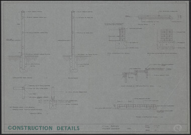 University of Melbourne, Burnley Campus Archives
Plan, Construction Details Student Gardens Burnley Campus, 1990
Tracing paper copy, Construction details for student gardens. Dated1 9.09.1990. By JK (Jill Kellow) . Scale 1:100.student gardens, burnley, vcah burnley, jill kellow -
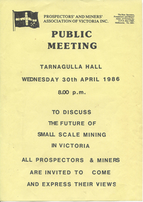 Tarnagulla History Archive
Notice of Public Meeting: Small Scale Mining, 1986
Donald Clark Collection.A notice for a public meeting about the future of small scale mining in Victoria. Held at Tarnagulla Hall on 30th April 1986. -
Glenelg Shire Council Cultural Collection
Plan - Plan / Line Drawings - Portland Harbour Trust Slipway Bilge Blocks Trawler Halcyon, Victoria, 23/04/1980
PORT OF PORTLAND AUTHORITYFront: '42' - black texta, top right corner -
Glenelg Shire Council Cultural Collection
Plan - Line drawing Portland Harbour Trust Marina jetty, mooring and fendering details, 29/09/1972
Front: '46' - black texta, top right cornerport of portland -
Federation University Historical Collection
Plan, Plan of Mount Helen, 7/7/1964
John [Jack] and Jessie Imogene[ Gene] Chatham purchased a subdivided property in Mount Helen. Chatham Ave Plan of Subdivisions to Mount Helen, Shire of Buninyong, Sheet 1 and Sheet 2 Scale 200 feet to one inchmidland highway, gear avenue, eddy avenue, shire avenue, boak avenue, moss avenue, rathkeale avenue, ingliston avenue, chatham avenue, mardango drive, nyora grove, yarana drive, shakespeare avenue, marina avenue, landale avenue, lylia avenue, recreation road, olympic avenue, the gums, heather avenue, dallas avenue, jones avenue, sebastopol mount clear road -
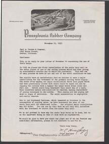 Bendigo Historical Society Inc.
Document - BILL ASHMAN COLLECTION: PENNSYLVANIA RUBBER COMPANY
Five copies of a letter to Paul A. Douden & Company from W. E. Humphrey, Chief Engineer, dated November 12, 1937. Paper has printed letterhead with a photo of the rubber company at the top. Writer mentions that they are pleased with the work of the Scale Buoys and that there is no scale in the pipes. Previously they had to replace piping regularly.sciences, instruments - general, scalebuoy, bill ashman collection - pennsylvania rubber company, paul a douden & company, w e humphrey -
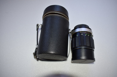 Warrnambool and District Historical Society Inc.
Camera Lens, 1 Soligor Lens. .2 case, C 1960
A manual detachable camera lens is used to focus the subject of which the photograph is to be taken . They have adjustments for distance and clarity while more complex ones can be fine tuned to a much greater degree. Photographs provide a invaluable resource from an historic perspective of past times people and events.This lens has significance as part of the continuum of camera development and use. It was owned by a local Warrnambool person who had a keen interest in photography..1 Black plastic and metal detachable camera lens with metal sections and graduated markings around the cylinder . There is a screw cap on one end where the lens is attached to the camera for use and the other end covering the lens itself has the brand name across the middle of cap. .2 Black leather cylindrical case with strap handle attached with silver metal hiinge and metal zipper towards the top section of the case. The lidded section has the brand name imprinted into the surface of the top..1 Lens made in Japan. Graduated scale from 1.5/5 to 20/50 .2 Soligor camera lens, warrnambool, history of warrnambool, soligor lens -
 Nhill Aviation Heritage Centre
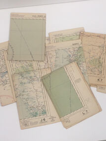
Map - Aeronautical Maps x 9, May 1943
Typical of the maps used during navigation training here at Nhill during WW2Aeronautical maps of Victoria, Printed on light card green text and markingsThird Edition May 1943, Sheet K8, Australian Aeronautical Map, Equatorial scale 1:1000,000map, aeronaughtical map, navigation -
 Federation University Historical Collection
Map, Ballarat and Sebastapol Gold Mines, Late 19th Century
colored printed map on paper lined onto linen backingprinted "Rider & Mercer's Plan of the Ballarat & Sebastapol Gold Mines Scale 30 Chains to One Inch"gold mines, mine allotment map, mining leases, ballarat, sebastopol, rider and mercer, golden shaft co, prince of wales and bonshaw united, leviathan gold mines, holst and co, speedwell co, sebastopol plateau, rothschild co, tower hill co, south plateau, south star co, band of hop and albion consols, prince regent co, chenhall and co, despza, buninyong estate, one eye hully, winter's freehold, luplau plateau, e. morey, carrill's quartz -
 Kew Historical Society Inc
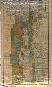
Map, MMBW, River Yarra Beautification Schemes, c.1913
The Melbourne and Metropolitan Board of Works (MMBW) was established by an act of the Victorian Parliament in 1890 to prepare for and to implement a sewerage and water reticulation system across what was then inner Melbourne, its surrounding and middle distance suburbs, including Kew. The MMBW was disbanded in 1991.The map collection of the Kew Historical Society has at its core the historic maps assembled and originally stored in the City Engineer's Department of the City of Kew. These include maps in a number of scales. The vast majority of maps were produced by the MMBW in the first two decades of the twentieth century, and are solid working maps, backed by linen for durability. These maps are historically significant to Kew, the City of Boroondara and to the history of the development of state utilities in Victoria. A number of the Kew maps have additional details added by former municipal officers, including the levels reached by various floods. As these were working documents, information was added to them long after the period of their initial production and distribution.Map of the City of Kew showing part of the River Yarra Beautification Schemes. The map shows development to date and the flood levels reached in 1923 and 1924. This map may have been adapted from an earlier map, as most development in central Kew and Studley Park had occurred by this date yet numerous streets are not represented. Public buildings and institutions are clearly represented and named on the map as are significant public transport infrastructure (eg the Outer Circle railway).MELBOURNE AND METROPOLITAN BOARD OF WORKS / RIVER YARRA BEAUTIFICATION SCHEMES / SCHEME / SCALE 10 CHAINS TO AN INCHmelbourne & metropolitan board of works, mmbw maps, mmbw plans, city of kew, flood levels -- kew (vic.), cartography -
 Kew Historical Society Inc
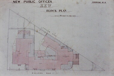
Slide - Architectural Drawing, Kew Public Offices, 1887
A civic campaign for new public offices developed in Kew in the 1880s. After much deliberation, the location chosen was the junction of Bulleen and Cotham Roads. The buildings were designed by George Watson and John Henry Harvey, architects within the Department of Public Works (Victoria). Building was commenced in 1887, and after one year, the buildings were opened. The Post Office was transferred to the new Commonwealth Government in 1901. The Police Station and Court House, sold by the Victorian Government to the City of Boroondara in 2007, are now a community cultural centre and performing arts venue.The buildings were listed on the Victorian Heritage Register Register (HO885) in 1991. They are historically and architecturally significant to the State Of Victoria because Watson and Harvey's designs exhibit diversity in integrating civil offices, they accommodate the apex of road junctions, and they demonstrate a departure from the contemporaneously favoured High Victorian Classical to the Queen Anne style in the design of civic buildings. 35mm colour transparency of an original plan by George Watson and John Henry Harvey, architects of the Department of Public Works (Victoria), in 1887 for New Public Offices at Kew. This plan was copied by the donor from an original held at the Commonwealth Archives in Brighton (Vic). The copy was made to illustrate a report that the donor made on ‘The functional planning design, building materials and construction methods of the Kew Post Office’ as part of course work at RMIT.NEW PUBLIC OFFICES KEW / BLOCK PLAN / SCALE 16 FEET TO ONE INCH / DRAWING NO 4kew court house, kew police station, kew post office, architectural drawings, khs - slides, new public offices — kew (vic.), architecture — queen anne style -
Stawell Historical Society Inc
Map, Underground Survey of the Principal Mines of Stawell 1879, 1879
Pleasant Creek & Newington, Prince Patrick, Prince Alfred, Pioneer and Galatea, Pleasant Creek Cross Reef No. 1&2, Magdala, Old Shaft, Extended Cross Reef, Crown Cross, Great Northern, Sloanes & Scotchmans, South Cross, 10 & 11 United Scotchmans South Cross, Scotchmans Shafts, North Scothmans, West Scotchmans, Emerald Isle & Rose of Denmark, Albion, South Scotchmans, Newington & Pleasant Creek, Pleasant Creek Cross Reef, Moonlight, Extended Cross Reef, Crown cross United, Great Northern ShaftVery large Map on cloth backing, showing cross sections of mines.Surveyed by H.C. Bates. Drawn by Arthur Edwards. October 30th 1879. Scales 120 feet to an inchmining, gold -
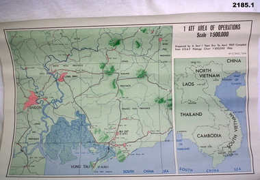 Bendigo Military Museum
Map - MAPS, VIETNAM, April 1969
1.) Paper map, colour with black print, scale 1:500,000 area covers Saigon, Long Bin, Nui Dat, Vung Tau. .2) Laminated paper map showing city of Vung Tau with details of tourist destinations, hotels, churches, black & red print, scale 1:12,500 approx.documents - maps - military & tourist, vietnam -
Frankston RSL Sub Branch
Binoculars
Binoculars of WW2 era with khaki woven canvas neck suspension strap. Scale and focus details stamped on facings and eye piecesStamped in right barrel facing V6/VFA 0220 Graticule 1/2 degree & 1/4 degree 1/2 degree & 1 degree High R.E.C./CANADA 1943 Stamped in left barrel facing No 2 Mk II Vertical Arrow C.G.B. 53 G.A. 6x30 2755 9-C 27559-C 4 2 0 2 4 graduations stamped on right and left eye pieces -
 Warrnambool and District Historical Society Inc.
Original Document, Map: Agricultural area of Ballangeich 1865, 1865
George Eddington arrived in Australia in 1839 and named and established property in 1841 calling the property Ballangeich after a Pass near his home town of Stirling in Scotland. It is situated 151 miles west of Melbourne and to the south of Mortlake and was originally part of the Mortlake shire, which was proclaimed 26th Jan 1864. Nearest streams are the Hopkins Riverand Lyall and Drysdale creek running through good agricultural land. This map relates to the breaking up of large runs which the Victorian government enabled through selection acts of the 1860's. The previously larger runs which were mainly cattle and sheep based were now more open to closer settlement and a greater variety in farming.The lots range in size from approximately 50 acres to around 600 acres.Some areas are set aside for reserves. By 1886 the population of Ballangeich had grown to around 600 with an hotel, three state schools and a church.Tri weekly coaches ran to Colac, Warrnambool and Camperdown providing access to supplies mail and communication. This map is typical of many which were produced in the 1860's in Victoria during a significant period of Victoria's and Warrnambool district history.Rectangular light card paper with black text showing allotments of land The area is coloured in green with scale at bottom right cornerAt the top: Plan of the Agricultural area of Ballangeich 1865 At the bottom left: Prepared by the Board of Lands & Works in accordance with the Amending Land Act 1865 Lands & Survey Office Melbourne 13th April 1865. With signaturehistory of warrnambool, ballangeich, land surveys victoria 1865, lands act 1865 victoria, ballangeich map 1865 -
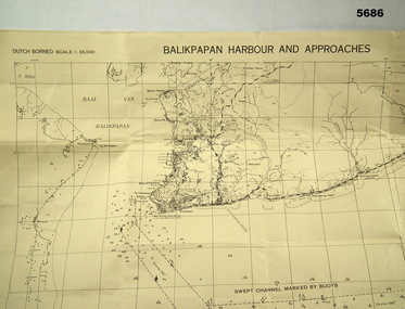 Bendigo Military Museum
Map - MAP, DUTCH BORNEO
Map identified height of land in area and depth of ocean on approached to Balikpapan Harbour. Identified piers, streets and defences and potentially used for landing or combat in the area. MAP PRODUCED BY 2/1 AUST ARMY TOPO SQN CO. Large Yellow paper map with scale of 1:36,000 of Dutch Borneo Balikpapan Harbour and it's approaches. Map folded into 8.balikpapan harbour, maps -
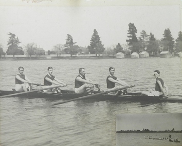 Ballarat Clarendon College
Photograph, 1921 B.P.S. Old Boy's Race
Gray-scale photograph on heavy card with smaller photograph inset at bottom right corner; two detached pieces of mount with inscriptionsInscribed on large piece of mount: BALLARAT OLD COLLEGIANS WINNERS / -NAMES- / J WOODWARD [BOW] H KNOX [NO 2] A DAWSON SEN [NO 3] A DAWSON [STR] A KING [COX] Inscribed on smaller piece of mount: B.P.S. / OLD BOYS RACE 1921