Showing 1854 items matching "subdivisions"
-
 Whitehorse Historical Society Inc.
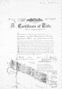
Document, Certificate of Title, 19/07/1918
Photocopy of Certificate of Title Vol. 4156 Folio 831198 for 43 acres Fronting on Canterbury Road near Mitcham Road, being part of Crown Portion 124, Parish of Nunawading, County of Bourke in the name of James Harley Malcolm, 19/7/1918. Last subdivision dated 22/5/1926- current site of Glenburnie Roadland subdivision, malcolm, james harley, mitcham road mitcham, glenburnie road mitcham, canterbury road mitcham, various surnames -
 Whitehorse Historical Society Inc.
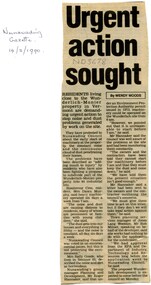
Article, Urgent action sought, 1990
Residents living close to Wunderlich-Monier in Vermont are demanding urgent action to stop noise and dust problems generated by work on the site.Residents living close to Wunderlich-Monier in Vermont are demanding urgent action to stop noise and dust problems generated by work on the site. Town planning services manager of Jones Lang Wootton, Rob McLiver, speaking for the developer said site works had nothing to do with the application for the subdivision, they have approval from the E.P.A. and the Department of Industry.Residents living close to Wunderlich-Monier in Vermont are demanding urgent action to stop noise and dust problems generated by work on the site. tile factories, wunderlich monier -
 Bendigo Historical Society Inc.
Document - Gemma Starr collection - Bendigo East Primary School - folder contains documentation of the support and submission to Council to Save the Bendigo East Primary School Avenue of Honour
Gemma Starr collection - Bendigo East Primary School - folder contains documentation of the support and submission to Council to Save the Bendigo East Primary School Avenue of Honour. Folder covers: Zoning, Policy, Maps, Heritage, Amenity and Trees documentation. Submissions had concerns about the subdivision, and the removal of trees on the site, impacting the school building.social, local history, bendigo east primary school, planning permit and objections -
 Bendigo Historical Society Inc.
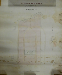
Plan - MARKS COLLECTION: PLAN OF G. LANSELL'S GOVERNOR'S PARK, TOORAK
Plan (tightly rolled) drawn on heavy paper mounted on fabric. On top of plan printed 'Governor's Park Toorak, late Vice-Regal Estate, the property of G. Lansell Esq' On top of plan Yarra River, on bottom Toorak Road, Plan shows subdivision, in centre of which is drawn outline of 8 acres containing the 'Mansion and Grounds'.bendigo, hospital -
 Glen Eira Historical Society
Document - St. Georges Road, 10, Elsternwick
A typed research report dated to 25/11/1987 by H. Bullock and R. Landells discussing the history of the ownership and occupancy of Kent at 10 St. Georges Road, Elsternwick and briefly the history of the street’s subdivision.kent, st. georges road, elsternwick, davis p., duffy road, george street, copland oeric rev., eberach louis, lynch james, white charles j., white a. a. miss, smith h. w., sherlock j. mrs, sharp frederick j., ripponlea, elsternwick railway station, bullock h., landells r., land subdivision, victorian style, house names -
 Ringwood and District Historical Society
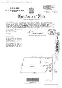
Document - Certificate of Title and Maroondah Heritage Study, "Elouera", 59 Bemboka Road, Warranwood, Victoria, previously part of Crown Section 20, Parish of Warrandyte, County of Evelyn - 4th February, 1987
Property subsequently subdivided into residential allotments with formation of Aspen Court, Warranwood, circa 2010.A4 copies of Landata Victoria documents - Vol 9725 Fol 210 derived from Vol 9701 Vol 469, and 2-page Heritage Study report.Ian Vance Lloyd and June Josephine Lloyd are joint proprietors of an estate in fee simple - Lot 4 on Plan of Subdivision no.204137B shown on the map. Subdivision includes Bemboka Road. Encumbrance E-1 later extended through Lot 4 as Aspen Court. Transfer - Proprietor June Josephine Lloyd - 29 July, 1993. Documents include 2-page Heritage report for study conducted prior to subsequent Aspen Court residential development circa 2010. -
 Ringwood and District Historical Society
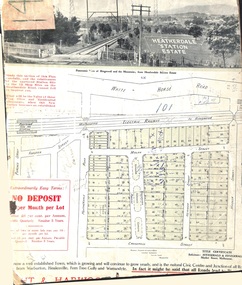
Card - Land Subdivision Clipping, Heatherdale Station Estate, Ringwood, Vic. - circa 1923
Cardboard-backed partial front page copy of a land sale advertisement map with penciled sales notations for some blocks.Subdivision includes Heatherdale Road, Molan Street, Yallourn Parade, Newman Street, and Madden Street. Location map inset shows Purches Street and Forster Street, Mitcham, and approved site for Heatherdale railway station. -
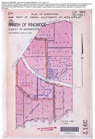
 Ringwood and District Historical Society
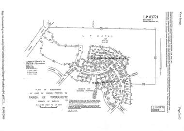
Document - Subdivision Plan, LP83721 - Part of Crown Portion 23, Parish of Warrandyte, County of Evelyn - 1969
A4 LANDATA Land Victoria plan printout dated 2009Two A4 maps of residential subdivision off Wonga Road, Ringwood. Enlargement map includes Holyrood Crescent, Berkley Road, Carmen Court, Frederic Drive, Kenwood Crescent, Marilyn Street and Adele Court. -
 Bendigo Historical Society Inc.
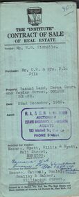
Document - H.A. & S.R. WILKINSON COLLECTION: CONTRACT OF SALE
Contract of sale of real estate dated 22nd December, 1960 between Mr. W. B. Nicholls (vendor) and Mr. C. W. & Mrs. F. L. Silk (purchaser). Solicitor for vendor: Messrs Hyett, Willis & Hyett, Bull Street, Bendigo. Solicitor for purchaser: Messrs. Tatchell, Dunlop, Smalloy & Balmer, Williamson Street, Bendigo. Property: vacant land corner Derna Court and Poplar Street, Golden Square, being lots 20,21,22,23,24, 25, 26 and 27 fronting Derna Courton plan of subdivision no. B80611 and lot 1 on plan of subdivision no. 51583 lodged in the office of titles and being part of Crown allotment 11 section 24A at Bendigo described in Crown grant volume 8217 folio 121. Price 4,900 pounds .organization, business, h.a. & s.r wilkinson real estate -
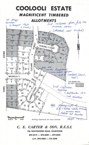 Ringwood and District Historical Society
Document - Folder, Coolooli Estate Subdivision, Ringwood East, Vic. - Four Releases 1969-1975
Collection of Subdivision Plans, Land Sale flyers, Auction notices, and Real Estate Agent's notes for Coolooli Estate, Ringwood East, Victoria. Subdivision includes Coolooli Court, Isabel Avenue, Walhalla Drive, Cleland Street, Landell Court, Byways Drive, Heathwood Street and Hume Street, released over four stages - First Stage auction 16 August 1969, Second Release private sales from July 1970, Third Release Auction 11 September 1971, Final Release auction June 21st 1975. Agents - C.E. Carter & Son, 126 Whitehorse Road, Ringwood until moving to 122 Whitehorse Road in 1973 - Tel. 870 6024, 870 6830, 870 2519, A.H. 723 3298, 870 6960. Digitised copy of photograph - A.B. Carter and Andy McLean at Coolooli Estate auction, 11 September, 1971. -
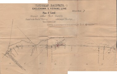 Bendigo Historical Society Inc.
Document - BUSH COLLECTION: PLANS PERTAINING TO LAND OF S. A. BUSH
A: Plan of subdivision of Allots 6, 7, 8, 15 & 16, Sec. 62C, City of Bendigo (The Property of Albert Bush, Esq.) - Plan is torn in half forming two pieces (see 'Condition'. Pinned note attached to one piece. B: Victoria Railways, Eaglehawk & Kerang Line (Albert Bush land, Parish of Nerring, County of Bendigo.person, individual, bush collection - personal -
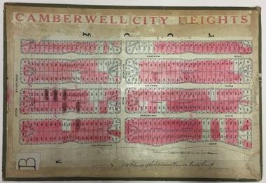 Kew Historical Society Inc
Plan - Subdivision Plan, Jas R Mathers Son & McMillan, Camberwell City Heights, 1922
"Following the 1919 amalgamation of suburban tramway trusts, an electrified tram service extended along Doncaster Road. Housing estates such as the 1919 Balwyn Park Estate, 1922 Hillcrest Estate and the Camberwell City Heights Estate, also 1922, quickly followed. These estates were built over by expansive suburban villas, set in fine gardens and along tree-lined streets. North Balwyn, largely constructed since 1933, was typified by even grander houses, many of them in the 'ocean liner' style and seen at their most distinctive in the Riverview Estate." (Source; 'Balwyn' in eMelbourne)Portions of subdivision plan mounted on both sides of cardboard sheet. Coloured pink, probably to show allotments sold. Area covered: Doncaster Road, Mountainview Road, Panoramic Road, Cityview Road, Longview Road, Riverview Road, Hillview Road, Bulleen Road. Includes location diagram showing railway lines and existing and proposed tram routes.Cardboard backing has advertisement for "Tillock's soluble coffee"subdivision plans -- camberwell (vic.), camberwell city heights subdivision -
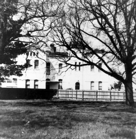 Surrey Hills Historical Society Collection
Photograph, Nethercourt Private Hospital in Union Road Surrey Hills, 1976
The 3 front blocks facing Union Road were subdivided off in circa 1967, so this building now faces Barton Street. Since 1984 it has been a private residence. It was originally built in c1890 and from 1896 it was used as facilities for Surrey College, a private boys' boarding school. Dr F Darling was Principal. From 1935-1960s it became Nethercourt Private Hospital. This had previously operated from 1921 in Wilson Street. Later it was known as St Jude's Hospital; this closed in 1983.Black and white photo of Nethercourt Private Hospital taken from Union Road. It shows a 3 storey brick rendered building painted in a light colour. It is fronted by a paling fence and with a vacant area in the foreground, on which there is a bare-leafed mature tree to the right and an evergreen tree to the left. The fence appears to be new suggesting that the photo was taken at the time of subdivision of the land.The original has the following inscriptions: Top: In black biro "D Hall our collection / hall / family" in Jocelyn Hall's writing. Below in lead pencil "Old entrance of / St Judes" - unknown hand; presumed to be Duncan Hall's. In black biro in Jocelyn Hall's hand: "Taken c. 1976." nethercourt private hospital, the surrey college, norwich hall, st judes hospital, barton street, medical services, education, dr f darling -
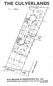 Ringwood and District Historical Society
Document, Subdivision Plan - The Culverlands Estate, Heathmont, Victoria (undated, circa 1968)
Map of residential allotments for sale, with handwritten pricing notations and some marked "Sold". Subdivision includes Culverlands Road, Swain Court, Pleasant Drive, Barbara Court, and Armstrong Road, Heathmont. Agent - H.G. McLean & Associates Pty. Ltd., 166 Canterbury Road, Heathmont Vic., 3135, Telephones : 870-3422 A/hrs 870-5879 and 729-2809. -
Clunes Museum
Map - PLAN / MAP
.1 MAP, TOWN OF CLUNES, PARISH OF CLUNES, COUNTY OF TALBOT, STAMPED BOROUGH OF CLUNES .2 PLAN OF SUBDIVISION OF PART OF CLUNES COMMON, BOROUGH OF CLUNES, PARISH OF CLUNES,COUNTY OF TALBOT. P. CAMPBELL. ASSISTANT SURVEYOR, MARCH 1904 ON RIGHT HAND BOTTOM CORNER C71/1 CLUNES COMMON. MARKED: CHARTED R.L.A.7/2/57.1 PHOTO LITHOGRAPHED. DEPARTMENT OF LANDS AND SURVEY, MELBOURNE .2 PHOTO LITHOGRAPHED AT THE DEP. OF LANDS AND SURVEY, MELBOURNE PRICE 1/- 10.11.08map town of clunes, borough of clunes, parish of clunes, county of talbot -
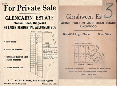 Ringwood and District Historical Society
Document - Folder, Land Sale Advertisement, Glencairn Estate and Girrahween Estate, Ringwood - circa 1950s
Single sided advertisement for private sale of residential allotments - undated, circa 1950s.Subdivisions include Mullum Mullum Road,Glen Cairn Avenue (Glencairn), Oban Road, and Norman Avenue (later Hugh Street). Agent - A.T. Miles & Son, 175 Main Street, Ringwood, Phone WU 6215. -
Glen Eira Historical Society
Document - Vadlure Avenue, 2, St. Kilda East
Printed and handwritten research from Brighton Historical Society giving brief details on 2 Vadlure Avenue, regarding subdivision of land formerly grounds of Kilwinning and residents of property from 1931 to 1974. Dated 19/01/1988.vadlure avenue, st. kilda east, service james, land subdivisions, 'kilwinning', denman street, kosky samuel, mcardle daniel j., elisha e., elisha d., bullock h., landells rosalind -
Glen Eira Historical Society
Map - CAPLES PLACE SUBDIVISION
This file contains a copy of a map of the CAPLES PLACE SUBDIVISION, undated and author unknown. The map provides the dimensions of roads and allotments in the area, including also handwritten notes from the original document and others written directly onto the copy.land subdivisions, documents, maps, glen eira, caples place, caples place subdivision, land surveys, orrong road, mulgrave road, prahran grove, somerset road, prahran grove, prahran grove, east walk, land allotments, town planning, garden road -
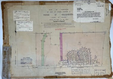 Greensborough Historical Society
Poster - Planning Document, City of Heidelberg et al, Subdivision Plan # H 41 - Crown portion 8, Parish of Keelbundoora - Yallambie, and Crown Portion 9, Parish of Keelbundoora, 1922-1967
Planning Document: Subdivision Plan # H 41 Side 1, Crown portion 8, Parish of Keelbundoora - Yallambie Road, Allima Avenue, Koolya Court, Ekam Court (Jennings Estate). Side 2: Crown Portion 9, Parish of Keelbundoora consist of 5 small subdivision sheets: 1. Somers Avenue, Stewart Terrace, Toubay Street and Railway Place (no date); 2. Somers Avenue, Maxwell Street, Greensborough Road, 1924; 3. Heidelberg Avenue, Golf Avenue, St Andrews Avenue (no date); 4. Birdwood Avenue, May Street (no date); 5. Strathallan Road 1924.An example of hard copy subdivision plans from the Greensborough area. Mainly from the Shire of Diamond Valley era (1964-1994).Plan (2 sided) mounted on heavy card. Stamped and handwritten Council permissions, dates and other details.subdivision plans, city of heidelberg, yallambie, macleod, greensborough -
Glen Eira Historical Society
Plan - Nithsdale
This file contains one item about this property: Three postcard sized photographs of a flyer for the subdivision sale of the area incorporating this property for Saturday 22/11/1924. The flyer shows photographs (black and white) and plan of the area around 'Nithsdale'.nithsdale', caulfield north, hudson street, bambra road, kambrook road, centre way, oak court, caulfield railway station, balaclava road, glenhuntly road, caulfield racecourse -
Ringwood and District Historical Society
Agreements, Stillwell and Co, Contracts of sale of land in Ringwood 1911-1925 (Aird Orchard), 1911-1915
Details of contracts of sale of land in Ringwood between 1911 and 1915 executed by Mr Aird - subdivision of orchard between Adelaide Street and Andersons Creek Road (Warrandyte Road). In 1975, the house was the Presbyterian Manse. Orchard owned by J.G. Aird.12 contracts of sale of land in Ringwood between 1911-1915 executed by Mr Aird - buff coloured foolscap bifold documents with black printing and some handwritten. +Additional Keywords: Aird, J.G. -
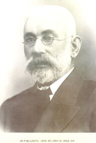 Port Fairy Historical Society Museum and Archives
Photograph, Cr P McGrath Shire of Belfast President 1879-80-81, 82-83
Councillor P.McGrath lived on the Koroit-Woolsthorpe Road and engaged in farming pursuits. He gained fame by his masterly handling of the subdivision of the Shire into 3 Ridings practically of equal valuation and they remained that way until the amalgamation of the shire and the Borough council.Black and white portraitgovernment, belfast, president, portrait, shire, council, municipal, local-government -
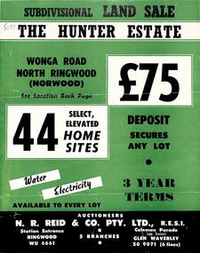 Ringwood and District Historical Society
Flyer, Land Sale Brochure, The Hunter Estate, North Ringwood, Vic. - circa 1960
Bi-fold land sale advertisement for The Hunter Estate, North Ringwood, including terms of sale, area map, layout of the estate, and summary of local facilities and services, with separate attachment listing lot number prices.Subdivision includes Wonga Road, Hunter Avenue (later Graeme Avenue), Panfield Avenue, Hendra Grove, and Mullum Mullum Road. Agent - N.R. Reid & Co. Pty. Ltd., Station Entrance, Ringwood. (Phone) WU 6661. -
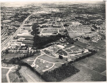 Ringwood and District Historical Society
Photograph, Aerial View of Ringwood, Victoria - circa 1970
Black & white west-facing view over Oban Road along Mullum Mullum Road and Creek. Foreground showing early subdivision development of "Dunn's Orchard Estate" with formation of Frederic Drive (named after the orchardist - Frederic Dunn), Baron Court, Towerhill Drive, Tyson Court, Adele Court, Marilyn Crescent, Abbey Court, Highland Boulevard, Ailsa Court. -
 Ringwood and District Historical Society
Document, Sale of Land Act documents - Part of Crown Allotments 14A, 40A, 40B & 4C, Parish of Ringwood - 1895
Certificate of Title - Georgina Elizabeth Wingfield Knox, wife of William Robert Knox, part of allotments 14A and 40A, 27th November, 1895, and subsequent transfers up to 1959. Plan of Subdivision includes Allens Road, The Greenway, Dickasons Road, and Canterbury Road, Ringwood. (With further residential and commercial developments taking place since the 1920s, this area became part of the suburb of Heathmont.) -
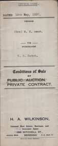 Bendigo Historical Society Inc.
Document - H.A. & S.R. WILKINSON COLLECTION: CONTRACT OF SALE
Conditions of sale by private contract dated 13th May, 1937 between Mrs. M.H. Amor (seller) and V.F. Sutch (buyer) for land situate Hayes Street, Bendigo being lot 2 on plan of subdivision, having a frontage of approx. 57 feet to Hayes Street, by a varying depth, being part of Crown allotment 510 section A. Price 60 pounds.organization, business, h.a. & s.r wilkinson real estate -
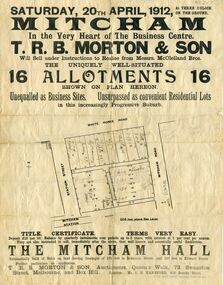 Whitehorse Historical Society Inc.
Document, Mitcham Hall, 1912
Subdivision of landAdvertising poster relating to the Subdivision of land surrounded by Mitcham Station, Station Street, Whitehorse Road and Mitcham Road, for sale by auction Saturday 20th April 1912 under instructions from Messrs. McLelland Bros.. Also the sale of Mitcham Hall. Auctioneers T.R.B. Morton, Melbourne and Box Hill. Hall used by Girl Guides until its demolition in 1988.Subdivision of land mitcham hall, land subdivision, t. r. b. morton & son, station street mitcham, mitcham road, mitcham, whitehorse road mitcham, mclelland bros. -
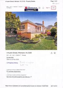 Whitehorse Historical Society Inc.
Document - Various including maps, titles, posters, Land ownership of 4 Austin Street, Mitcham, 1873 - 2019
Ownership history of 4 Austin Street, Mitcham.Ownership history of 4 Austin Street, Mitcham between 1873 to 2019, including the plan of the Mellorton Estate, Mitcham (1923), showing some lots priced at one hundred and forty-five pounds and the Charlesworth Estate ((1913). The Austin Street house was purchased by Martin and Shirley Gleeson 1956 and sold in 2019. Subdivision map of area south of Burnett Street to Harrison Street. non-fictionOwnership history of 4 Austin Street, Mitcham.drake real estate, charlesworth estate mitcham, mellorton estate mitcham, austin street mitcham no4, ainger frank -
Kew Historical Society Inc
Archive (Sub-series) - Subject File, Kew Historical Society, 'Goldthorns' (Houses, Kew), 1958
Various partiesReference, Research, InformationSecondary Values (KHS Imposed Order)Subject file containing Executor's Auction, Sunday 24th October 1931, "Goldthorns", Normanby Road, Corner of Argyle Road, Kew’ - Four page flyer advertising the sale of Goldthorns in Normanby Road, Kew in October 1931. The flyer contains a photograph of the front of the house, a list of its rooms, a site plan (including possible subdivisions) and a photo of the extensive rear garden.goldthorns - normanby road - kew (vic),, goldthorns estate, mansion - kew (vic), gardens - kew (vic), griffiths family, subdivisions - kew (vic)goldthorns - normanby road - kew (vic),, goldthorns estate, mansion - kew (vic), gardens - kew (vic), griffiths family, subdivisions - kew (vic) -
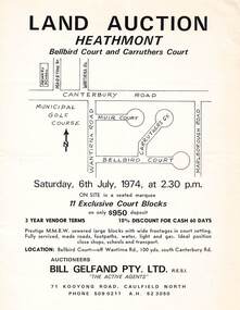 Ringwood and District Historical Society
Flyer - Land Auction, Carruthers Estate, Heathmont, Victoria - 1974
Double-sided page advertising auction of 11 allotments on Saturday, 6th July, 1974, with locality map and plan of subdivision in Carruthers Court and Bellbird Court, Heathmont. $950 deposit, 3 year vendor terms, 10% discount for cash 60 days. Handwritten notation indicating Lot 22 "sold for $127,000 - all other lots passed in around $11,000".Auctioneers - Bill Gelfand Pty. Ltd., R.E.S.I. 71 Kooyong Road, Caulfield North, Phone 5090211 A.H. 523050.