Showing 920 items
matching suburban
-
 Eltham District Historical Society Inc
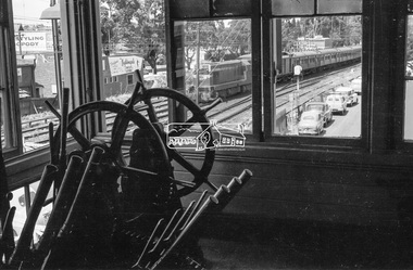
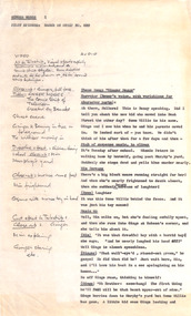
Photograph, George Coop, Box Hill Signal Box, c.Feb. 1964
A T-class diesel-electric locomotive can bee seen through the window hauling a Tait train. Also advertising on the buildings facing passing train passengers including 'Dialyn's Theatre Shoppe for Nightingale Tightlets & Leotards'. This is not a conventional suburban Tait ‘Red Rattler’ service. It may have come from Lilydale where trains from both Warburton and Healsville were combined to continue the run into Melbourne, a normal service for them at the time. It is unusual as the train is hauled by a diesel which also suggests it may have been a special excursion train from either of those two towns. Normally these combined trains would be hauled by two swing door ‘Red Rattlers’ motor coaches from Lilydale, the start/end of electric service. Digital TIFF file Scan of 35mm Ilford FP3 black and white transparencygeorge coop collection, box hill railway signal box, box hill railway station, signal box -
 Flagstaff Hill Maritime Museum and Village
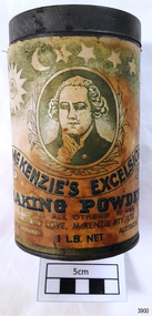
Container - Tin, McKenzies Foods, circa 1930s
This tin once contained McKenzie’s baking powder, a cooking ingredient. It was donated with other similar tins that were used by the donor’s mother who was married in 1932. It those times in Australia all manner of household items, including food and drink, were sold by hawkers (salesmen) who travelled from door to door in both suburban and rural areas. The donor remembered the bicarb soda tin on her mother’s pantry shelf. The McKenzie’s Baking Powder label adds the information that the ingredients were “Prepared with Aerophos, Regd. Trade Mark, the finest raising ingredient. A product of Albright & Wilson, Australia Pty. Ltd.” It also says that it “Excels all others in use”. The company began in Melbourne in 1852 and continues today, now run be the fifth generation of descendants from the original owners. This tin originates in the early 1900s from an Australian company that is now managed by fifth generation descendants of the original family after its inception in 1852. The tin increases in significance for its use as a recognised object found in many Australian kitchens since early days. It gives a snapshot into domestic life and social norms of the pre and post war period in Melbourne The tin is significant for its association with a local family in the 1930s for the preparation of family meals. Tin container, cylindrical, with cream and green paper label with gold highlights, motif and text. Used for selling McKenzie’s Excelsior baking powder. Container has push-on lid. Quantity of 1LB. NET. Made in Australia by McKenzie Ltd.Text includes “CLIFFORD LOVE, McKENZIE PTY. LTD.” “McKENZIE’S EXCELSIOR / BAKING POWDER”. Motif: man’s portrait within oval frame with wheat sheaf border, placed below figures of sun, moon and stars. Information and instructions. flagstaff hill asset, baking powder tin, container, flagstaff hill museum, kitchen item, cooking ingredients, flagstaff hill, warrnambool, shipwrecked coast, flagstaff hill maritime museum, maritime museum, shipwreck coast, flagstaff hill maritime village, great ocean road, tin, cooking ingredient, food container, grocery, cookery, rising agent, baking powder, mckenzie, mckenzie foods -
 Kew Historical Society Inc
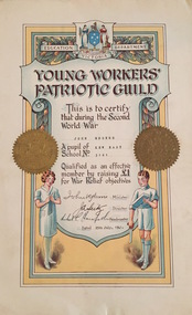
Certificate, Education Department (Victoria), Young Workers Patriotic Guild, 1941, 1941
The Young Workers Patriotic Guild was originally established in World War I and reestablished in World War II. The Collection includes a number of items produced under this banner from both the First and Second World Wars. This work forms part of the collection assembled by the historian Dorothy Rogers, that was donated to the Kew Historical Society by her son John Rogers in 2015. The manuscripts, photographs, maps, and documents were sourced by her from both family and local collections or produced as references for her print publications. Many were directly used by Rogers in writing ‘Lovely Old Homes of Kew’ (1961) and 'A History of Kew' (1973), or the numerous articles on local history that she produced for suburban newspapers. Most of the photographs in the collection include detailed annotations in her hand. The Rogers Collection provides a comprehensive insight into the working habits of a historian in the 1960s and 1970s. Together it forms the largest privately-donated collection within the archives of the Kew Historical Society.Young Workers Patriotic Guild Certificate - An illuminated Young Workers Patriotic Guild certificate issued by the Education Department Victoria. The certificate testifies that John Rogers who was a pupil at Kew East School raised £1 for War Relief objectives in 1941. young workers patriotic guild, second world war 1939-1945, george rogers -
 Ballarat Tramway Museum
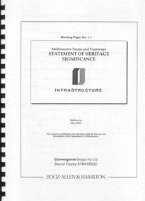
Document - Report, Boyce Pizzey and Booz Allen & Hamilton, "Working paper No. 1.1, Melbourne's Tram and Tramways Statement of Heritage Significance", May. 2000
Bound report, 48 pages, clear plastic front cover, black card back cover, and black comb binder titled "Working paper No. 1.1, Melbourne's Tram and Tramways Statement of Heritage Significance". Prepared for the Dept. of Infrastructure, May 2000, by Booz Allen & Hamilton, Convergence Design Pty Ltd and Boyce Pizzey Strategic. Provides a background, evolution of Melbourne's Tramways, Elements if Significance, the tramway system as an entity. Social and Cultural Influences and a Statement of Significance. Provides a brief history of the Melbourne's Trams and Tramways as an appendix along with some photographs, maps, sources, bibliography, illustrations, photographs, a list of Melbourne and suburban tramways, a list of Pre-MMTB cars, and MMTB cars preserved in Museums in Australia. Has corrections on the list. As a loose item, has a list of corrections prepared by Warren Doubleday. See Reg items 4264 and 4265 for associated papers. Various pencil notes throughout by Warren Doubledaytrams, tramways, melbourne, heritage, trams, museum, conservation -
 Glen Eira Historical Society
Article - PRENTICE STREET, 47, ELSTERNWICK
Three sets of real estate campaigns for this property: 1/Property Review Weekly newspaper article date 13/12/2002 includes one coloured photograph. The article gives details of renovations done ten years previously and modern features for efficient energy. Also notes suburban locality features. 2/Newspaper article 03/02/2003 gives brief detail on home features both this and above include similar coloured photograph. 3/Newspaper article dated March 2009 gives detail on home features and garden amenities. 4/Real estage agent A4 flyer plus small newspaper ad (Domain 19/04/2013) for auction of 11/05/2013. Included are 2 colour exterior (front and rear) plus 2 colour interior photos for this Edwardian home.prentice street, elsternwick, peer gary, estate agents, timber houses, stefanis angelos, stavrakis bill, kelly juanita, bigginscott, edwardian style -
 Robin Boyd Foundation
Document - Script, Robin Boyd, Ginger Meggs Pilot Episode, 1963
Ginger Meggs, Australia's most popular and longest-running comic strip, was created in the early 1920s by Jimmy Bancks. The strip (based on Strip No. 589) follows the escapades of a red-haired prepubescent mischief-maker who lives in an inner suburban working-class household. This story follows characters Ginger and Mim, and their attempt to find and get an apology from new kid, Osmo Willis who plays a prank with a toy mouse on Mim. Ginger goes to Osmo's house to get an apology from him to Mim, but instead Osmo invites Ginger to his birthday party. Ginger then takes Osmo to buy ice-cream. Ginger in the end, gets caught out in his lie to Mim, that he couldn't find Osmo. Min finds out and scolds Ginger for being deceitful. "If only you were half a gentleman..." she says.Crawford Productions and Robin Boyd also explored ideas for other television productions, besides the successful 'The Flying Dogtor" series.Typewritten, carbon copy, foolscap, 3 pagesHandwritten side notes by Robin Boyd in pencil.ginger meggs, cartoon strip, jimmy bancks, robin boyd, crawford productions -
 Kew Historical Society Inc
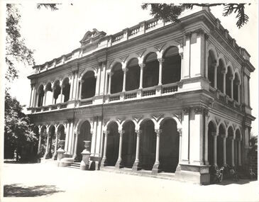
Photograph - 'Ross House', Cotham Road [Kew], c.1960
Ross House, formerly called Charleville, was built as a two-storey mansion in 1889 for Charles Donaldson. It was designed in the Italianate style by the architect H. Shallers and built by G. Ginham. Dr Tom King, surgeon purchased Charleville from Donaldson in 1939 and renamed it Ross House. This work forms part of the collection assembled by the historian Dorothy Rogers, that was donated to the Kew Historical Society by her son John Rogers in 2015. The manuscripts, photographs, maps, and documents were sourced by her from both family and local collections or produced as references for her print publications. Many were directly used by Rogers in writing ‘Lovely Old Homes of Kew’ (1961) and 'A History of Kew' (1973), or the numerous articles on local history that she produced for suburban newspapers. Most of the photographs in the collection include detailed annotations in her hand. The Rogers Collection provides a comprehensive insight into the working habits of a historian in the 1960s and 1970s. Together it forms the largest privately-donated collection within the archives of the Kew Historical Society.Facade of Ross House (formerly Charleville) in Cotham Road, Kew. The image was selected by Dorothy Rogers for inclusion in 'A History of Kew' (1973), facing page 80.Ross House. Built 1889 by Donaldson. Known then as Charleville. Not published.ross house, charleville, cotham road, kew, dorothy rogers, charles donaldson, tom king, g. ginham, h. shallers -
 Kew Historical Society Inc
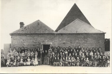
Photograph, Kew Common School, c. 1863
The Kew Common School, which had erected a new building in Peel Street only two years before the passing of the Education Act 1872, was retained and re-badged asState School No 1075, with numerous additions being made over the next few decades. This work forms part of the collection assembled by the historian Dorothy Rogers, that was donated to the Kew Historical Society by her son John Rogers in 2015. The manuscripts, photographs, maps, and documents were sourced by her from both family and local collections or produced as references for her print publications. Many were directly used by Rogers in writing ‘Lovely Old Homes of Kew’ (1961) and 'A History of Kew' (1973), or the numerous articles on local history that she produced for suburban newspapers. Most of the photographs in the collection include detailed annotations in her hand.The Rogers Collection provides a comprehensive insight into the working habits of a historian in the 1960s and 1970s. Together it forms the largest privately-donated collection within the archives of the Kew Historical Society.School photograph - The Kew Common School, located on the west side of Peel Street, Kew."Common School - Congregational Church. No.356. Photo taken early 1860s. School 356. Peel St., Rear of Congregational Church. Photo taken in early 1860s"kew common school, peel street (kew), dorothy rogers, education, kew state school -
City of Moorabbin Historical Society (Operating the Box Cottage Museum)
Newsletter - City of Moorabbin Historical Society No. 6 January / February 1962, City of Moorabbin Historical Society Newsletter No. 6 January / February 1962, 1962
This is Newsletter No.6 produced by CMHS President Mr T.A. Sheehy in January / February 1962 The Aims of the CMHS are ‘to record the history of the City, and register something of the Australian Atmosphere, which the necessary speed-up in post-world-war two (WW11) immigration has caused to be lost; to produce a magazine at regular intervals, featuring the work of pioneers and the changing Australian scene; to work constantly with a long range view towards building a hall where records and exhibits can be housed’ The Original Newsletters reflect the history and heritage of the former City of Moorabbin — derived from Mooroobin, ‘a resting place’ in the Bunurrung spoken language. In 1994, the City of Moorabbin was integrated into the Cities of Bayside, Glen Eira, Kingston and Monash. This Issue - Centenary Year Moorabbin; from Pastoral, Fishing, market gardening to suburban industrial; 'The Tuck Family'; Moorabbin City Band;This is No 6 Newsletter of CMHS January / February 196 CMHS obtained a Kingston City Council Community Grant 2016 for the digitization and preservation of these Original CMHS Newsletters commenced in 1961 2 x pages Foolscap paper printed on 1 side.CITY OF MOORABBIN HISTORICAL / SOCIETY / President T.A Sheehy ...... Ssecretary Mrs L. Harvey ...../ NEWSLETTER No 6 January / February 1962 -
 Ballarat Tramway Museum
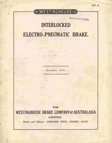
Document - Technical pamphlet/s, Westinghouse Brake Company of Australasia Limited and The Westinghouse Brake & Saxby Signal Co. Ltd. of 82 York Road and Kings Cross London, "The Westinghouse Brake with Electro-Pneumatic Control", Dec. 1926
2285.1 - 12 page technical pamphlet (2 sheets of paper - pages 5 -10 formed as a concertina folded centre sheet) titled "Interlocked electo-pneumatic brake", published by Westinghouse Brake Company of Australasia Limited, December 1926. Manual D.P. 9. Stapled with two steel staples along fold. Describes in detail the electro-pneumatic brake system as used on Sydney Suburban trains, complete with diagrams, brake valve operation, magnet valve and isolating cock switch. 2285.2 - Six page technical pamphlet, titled "The Westinghouse Brake with electro-pneumatic control", published by Westinghouse Brake and Saxby Signal Co. 1915. Pages 3 and 4 have been tipped in the cover sheet. Describes standard brake equipment for use with electric trains and electro pneumatic control over the brakes. Gives details of house the brake valve (No. 18 EP) operates. Scanned to the COTMA Website 4-10-2015."Colin Rutledge" stamped on top of page 1.trams, tramways, westinghouse, electric trains, electro - pneumatic brakes, sydney suburban trains -
 Melbourne Tram Museum
Functional object - Inspectors table holder, Melbourne & Metropolitan Tramways Board (MMTB), 1960's to 1980's
Tramway Inspectors table holder - two sheets of Perspex with a ruled card between them held with an elastic or rubber band. Use by Inspectors to hold headway cards which they hand wrote out to suit themselves and their method of monitoring services. Inspector's would use a soft pencil on the Perspex sheet to mark off the services as they past their monitoring point. Normally the card would be used to note the suburban terminus departure time, city arrival time, their monitoring point, eg a junction, and other major points. They could also record crew change overs for meals and with other trams on them and what runs their next did. (Advice from Peter Winspur 24-3-2016) Five additional blank copies of the cards from a donation of Kevin Tierney added 5/8/2016. Addition blank card from donation of Gavin Young added 22/12/2020.trams, tramways, mmtb, timetables, buses, trams, inspectors -
 Melbourne Tram Museum
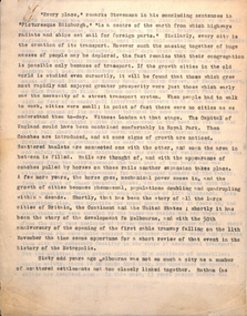
Document - Report, Parliament of Victoria, "Report of the Royal Commission - Railway and Tramway systems on Melbourne and Suburbs", Nov. 1911
Report - 42 pages, 3 sections, stapled on the left hand edge, titled "Report of the Royal Commission appointed to inquire into and report upon the Railway and Tramway systems on Melbourne and Suburbs" - dated 1911. Looks at the state of the Suburban rail system, finances, electrification's, costs, evidence of Mr. Merz, advantages of the electrification, power supply and standards, whether AC or DC, duplication, Glen Iris line, conclusions and recommendations. Tramway - summarises the current tramways operating, cable system and operational stats, the current tramway systems, other cities, relative merits, future tramways for Melbourne, operational speeds, use of cable conduits for electric traction, conversion, municipal control , control of the tramways by the railways, a general scheme, formation of a larger tramway trust and its management, purchase of the cable tramways and recommendations. Note: This document is available as a pdf on the Parliament of Victoria website. 2nd copy added 2-1-2019 from donation of Norm Cross.In ink in the top right hand corner "TB"trams, tramways, tramways, cable trams, finances, conversion, railways, royal commission, costs -
 Melbourne Tram Museum
Document, Melbourne & Metropolitan Tramways Board (MMTB), Melbourne cable tram history, late 1930's
Manuscript - 29 quarto sheets carbon copy - article for publication possibly about the history of the Melbourne cable tram system. Notes cover - the background of history of city transport, the suburban councils, the formation of the MTOC, the MTT - list the various council representatives, development of the cable system, Mr. George Duncan, Dunedin, construction works, maintenance, finances, funding, contractors, construction timing, list of lines and opening dates, winding houses, the various lines, construction issues with drainage, cable lengths, horse trams. The conversion of cable trams, annual returns for 1886 to 1935. Page 22 has a heading "Why a Prophecy was Unfulfilled" - which looks at the finances of the MTT and the folding into the Tramway Board and then the MMTB, including community obligations, the MMTB Act, conversion operations, the Chairman's tour of 1923, St Kilda Road conversion, and finally conversion of Elizabeth St and Victoria St. Article dated mid to late 1930's.trams, tramways, cable trams, melbourne, public transport, history, mto co, mtt, dunedin tramways, finances, contracts, cables, construction, track construction, conversion, mmtb, chairman, community services -
 Melbourne Tram Museum
Document - Report, Keith Kings, "The Privatisation of Melbourne's Public Transport - Has the wheel turned full circle?, Apr. 2002
Set of two reports by Keith Kings, titled "The Privatisation of Melbourne's Public Transport - Has the wheel turned full circle? for the Second Annual RMIT Sir Robert Risson Memorial Lecture. See Reg Item 4679 for the first lecture by Graeme Turnbull. .1 - 12 A4 pages - Keith notes that it was the actual handout of the presentation. Two copies, one stapled. 2 - 20 A4 pages, single sides - copy of the initially drafted document. Both copies have handwritten notes about their origin and use. The lecture looks at early railway development in Melbourne, private operators, development of horse drawn buses in Melbourne, competition, bus chassis, body builders, operators, private suburban operators, tramway buses, cable tram MTOCo, tramway trusts, Government involvement, formation of The Met, PTC, V/Line, corporatisation of public transport, franchising, passenger expectations of public transport, Yarra Trams and the future.trams, tramways, buses, cable trams, mto co, public transport, competition, yarra trams, franchising, the met, ptc, tramways -
 Flagstaff Hill Maritime Museum and Village
Container - Tin, McKenzies Foods, circa 1930s
This tin once contained McKenzie’s baking powder, a cooking ingredient. It was donated with other similar tins that were used by the donor’s mother who was married in 1932. It those times in Australia all manner of household items, including food and drink, were sold by hawkers (salesmen) who travelled from door to door in both suburban and rural areas. The donor remembered the bicarb soda tin on her mother’s pantry shelf. The McKenzie’s Baking Powder label adds the information that the ingredients were “Prepared with Aerophos, Regd. Trade Mark, the finest raising ingredient. A product of Albright & Wilson, Australia Pty. Ltd.” It also says that it “Excels all others in use”. The Australian family business, McKenzie’s Foods, began in Melbourne in 1852 and continues today, now run be the fifth generation of descendants from the original owners. Its baking and cookery products are well recognised by Australians. This tin originates in the early 1900s from an Australian company that is now managed by fifth generation descendants of the original family after its inception in 1852. The tin increases in significance for its use as a recognised object found in many Australian kitchens since early days. It gives a snapshot into domestic life and social norms of the pre and post war period in Melbourne The tin is significant for its association with a local family in the 1930s for the preparation of family meals. Tin container, cylindrical, with cream paper label with gold highlights, motif and text. Used for selling McKenzie’s Excelsior baking powder. Container has push-on lid. Quantity of 1/2 LB. NETT. Made in Australia by Jas. F. McKenzie & Co. Pty Ltd. Text includes “JAS. F. McKENZIE & CO. PTY. LTD. / AUSTRALIA“ “McKENZIE’S EXCELSIOR / BAKING POWDER”. Motif: man’s portrait within oval frame with wheat sheaf border, placed below figures of sun, moon and stars. Information and instructions. flagstaff hill asset, baking powder tin, container, flagstaff hill museum, kitchen item, cookery, baking, grocery, mckenzie, rising agent, food container, flagstaff hill, warrnambool, shipwrecked coast, flagstaff hill maritime museum, maritime museum, shipwreck coast, flagstaff hill maritime village, great ocean road, tin, cooking ingredient, baking powder, mckenqie -
 City of Kingston
Photograph - Colour, Paul Tresize, 1998
The name Mordialloc was derived from the name Moody Yallock, which comes from the Bunurong language. The Bunurong Peoples are the Traditional Owners of this area. The name means “high water” or “high creek”. In 1839, colonial authorities declared the mouth of the creek, and an additional 830 odd acres as an Aboriginal Reserve, although this proclamation was never gazetted. The reserved land included part of the Carrum Carrum Swamp which was abundant with wild life and natural resources. Regular encroachments, including land sales which began in 1863, were made on the land until 1878 when the Reserve was declared closed, and the land was opened up to land sales. Market gardening and suburban house lots quickly began to develop, and Mordialloc became a renowned picnic and holiday site. Mordialloc Creek is a popular bay side destination for local and visitors, and is a site for boating, kayaking, fishing and swimming, along with many other activities.Colour photograph of Mordialloc Creek, looking out to the bay. Many small fishing and leisure craft are moored on either side of the banks of the creek. To the right hand side can be seen parklands, while the left hand side has a small inlet in which more small crafts are moored.mordialloc, bunurong, traditional owners, suburbs, boats, fishing, waterways -
 City of Kingston
Photograph - Colour, 1998
The name Mordialloc was derived from the name Moody Yallock, which comes from the Bunurong language. The Bunurong Peoples are the Traditional Owners of this area. The name means “high water” or “high creek”. In 1839, colonial authorities declared the mouth of the creek, and an additional 830 odd acres as an Aboriginal Reserve, although this proclamation was never gazetted. The reserved land included part of the Carrum Carrum Swamp which was abundant with wild life and natural resources. Regular encroachments, including land sales which began in 1863, were made on the land until 1878 when the Reserve was declared closed, and the land was opened up to land sales. Market gardening and suburban house lots quickly began to develop, and Mordialloc became a renowned picnic and holiday site. Mordialloc Creek is a popular bay side destination for local and visitors, and is a site for boating, kayaking, fishing and swimming, along with many other activities.Colour photograph of Mordialloc Creek, looking inland.Small fishing and leisure boats are moored on either side of creek, with a view of the Mordialloc Bridge Hotel in the background.mordialloc, bunurong, traditional owners, suburbs, boats, fishing, waterways, hotel -
City of Kingston
Photograph - Colour, Paul Tresize, 1998
The name Mordialloc was derived from the name Moody Yallock, which comes from the Bunurong language. The Bunurong Peoples are the Traditional Owners of this area. The name means “high water” or “high creek”. In 1839, colonial authorities declared the mouth of the creek, and an additional 830 odd acres as an Aboriginal Reserve, although this proclamation was never gazetted. The reserved land included part of the Carrum Carrum Swamp which was abundant with wild life and natural resources. Regular encroachments, including land sales which began in 1863, were made on the land until 1878 when the Reserve was declared closed, and the land was opened up to land sales. Market gardening and suburban house lots quickly began to develop, and Mordialloc became a renowned picnic and holiday site. Mordialloc Creek is a popular bay side destination for local and visitors, and is a site for boating, kayaking, fishing and swimming, along with many other activities.Colour photograph of Mordialloc Creek, looking inland. Boats are moored on either side of the creek and the Bridge Hotel is visible in the background.mordialloc, bunurong, traditional owners, suburbs, boats, fishing, waterways, hotel -
 City of Kingston
Photograph - Colour, Paul Tresize, 1998
The name Mordialloc was derived from the name Moody Yallock, which comes from the Bunurong language. The Bunurong Peoples are the Traditional Owners of this area. The name means “high water” or “high creek”. In 1839, colonial authorities declared the mouth of the creek, and an additional 830 odd acres as an Aboriginal Reserve, although this proclamation was never gazetted. The reserved land included part of the Carrum Carrum Swamp which was abundant with wild life and natural resources. Regular encroachments, including land sales which began in 1863, were made on the land until 1878 when the Reserve was declared closed, and the land was opened up to land sales. Market gardening and suburban house lots quickly began to develop, and Mordialloc became a renowned picnic and holiday site. Mordialloc Creek is a popular bay side destination for local and visitors, and is a site for boating, kayaking, fishing and swimming, along with many other activities.Colour photograph of Mordialloc Creek with boats moored on both sides of the street and Pompei's boat yard visible on the right hand side of the creek., Main Street and St Brigid's Catholic Church are visible in backgroundmordialloc, bunurong, traditional owners, suburbs, boats, fishing, waterways, hotel, church -
City of Kingston
Photograph - Colour, Paul Tresize, 1998
The name Mordialloc was derived from the name Moody Yallock, which comes from the Bunurong language. The Bunurong Peoples are the Traditional Owners of this area. The name means “high water” or “high creek”. In 1839, colonial authorities declared the mouth of the creek, and an additional 830 odd acres as an Aboriginal Reserve, although this proclamation was never gazetted. The reserved land included part of the Carrum Carrum Swamp which was abundant with wild life and natural resources. Regular encroachments, including land sales which began in 1863, were made on the land until 1878 when the Reserve was declared closed, and the land was opened up to land sales. Market gardening and suburban house lots quickly began to develop, and Mordialloc became a renowned picnic and holiday site. Mordialloc Creek is a popular bay side destination for local and visitors, and is a site for boating, kayaking, fishing and swimming, along with many other activities.Colour photograph of Mordialloc Creek with boats moored on both sides of the street and Pompei's boat yard visible on the right hand side of the creek., Main Street and St Brigid's Catholic Church are visible in background.mordialloc, bunurong, traditional owners, boats, fishing -
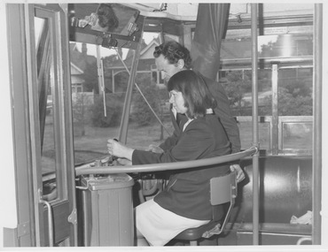 Melbourne Tram Museum
Photograph - Female driver training in Y1 class, from 1975
Photograph shows a female uniformed employee sitting at the controls of a Y1 class tram with a male in a suit standing to her right with his left hand on the back of the small driver's seat. The leather curtain used to enclosed the driver is open and stowed to the right. The tram appears to be on a suburban street but is stationary as the closeup photograph is taken from outside the tram. As this class of tram was used to train drivers at the Hawthorn Depot driver training school, the location may be close to this depot. The sloping driver's windscreen and long upper side window identify it as Y1 class. The female employee's summer uniform dress and jacket were introduced in 1975. Caps were no longer required, replaced with employee number badges worn on the uniform. This undated photograph is significant because the first female driver, Joyce Barry, was finally approved as a driver in 1975 after years of strong resistance by the tramways union. The staff member pictured is not Driver Barry. Yields information about driver training and female drivers Black and white print with no note.y1 class, leather curtain, driver training school, hawthorn depot, sloping drivers windscreen, caps, 1975, summer uniform dress, joyce barry, tramways union -
Ballarat Tramway Museum
Poster, Hocking ?, MTA 1985 Centenary, 1985
A group of four posters published for the centenary of Melbourne trams in 1985 by the Metropolitan Transit Authority 701.1 - Poster on creamy paper, title "The Centennial Celebration of the Melbourne Tram 1885 - 1985", features cable tram dummy, bogie cable trailer, horse tram, A, F, J, S, W2, U, SW2, Z3, and A class of 1984 on poster with three tickets illustrated as well. (two copies of this poster added June 2000 - from the ARHS Vic. Div., June 2000 These are black and white versions of the poster, on white paper, different in size - 640H x 445W) 701.2 - as for 701.1m but on glossy paper, titled "Tramways 1885 - 1985". 701.3 - Poster on glossy paper, featuring Melbourne Buses, titled "Buses 1925 - 1985", features 11 different bus types. 701.4 - Poster on glossy paper, featuring Melbourne suburban trains, titled "Railways 1854 - 1985", features 11 different railway trains, or pictures. Made by Hocking? -on bottom of each poster is a signature, appearing to be the name Hocking.trams, tramways, melbourne, centenaries, posters, public transport -
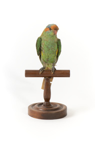
 The Beechworth Burke Museum
Animal specimen - Musk Lorikeet, Trustees of the Australian Museum, 1860-1880
The Musk Lorikeet is a bright coloured bird which commonly resides in south-eastern Australia. They also live in the drier areas of Tasmania. These birds are common in suburban and urban areas and are nomadic, meaning they are willing to travel significant distance to find flowering trees. The bright colours of this Lorikeet enable the bird to camouflage in dense foliage. This specimen is part of a collection of almost 200 animal specimens that were originally acquired as skins from various institutions across Australia, including the Australian Museum in Sydney and the National Museum of Victoria (known as Museums Victoria since 1983), as well as individuals such as amateur anthropologist Reynell Eveleigh Johns between 1860-1880. These skins were then mounted by members of the Burke Museum Committee and put-on display in the formal space of the Museum’s original exhibition hall where they continue to be on display. This display of taxidermy mounts initially served to instruct visitors to the Burke Museum of the natural world around them, today it serves as an insight into the collecting habits of the 19th century.This specimen is part of a significant and rare taxidermy mount collection in the Burke Museum. This collection is scientifically and culturally important for reminding us of how science continues to shape our understanding of the modern world. They demonstrate a capacity to hold evidence of how Australia’s fauna history existed in the past and are potentially important for future environmental research. This collection continues to be on display in the Museum and has become a key part to interpreting the collecting habits of the 19th century.The Musk Lorikeet is a beautiful species of parrot with mainly green plumage. it has a patch of yellow on the side of the breast which has faded to a grey on this specimen. This could be due to the impact of the taxidermy process or a product of time. The bird has an orange patch on the forehead and band through he eye to the ear coverts which has also faded from a brighter red colour. The crown of this bird is grey and would have been a grey-blue colour originally.87a / (89a)? Musk Lorikeet / See catalogue, page 24. /taxidermy mount, taxidermy, animalia, burke museum, beechworth, australian museum, skin, reynell eveleigh johns, bird, australian birds, lorikeet, musk lorikeet -
 The Beechworth Burke Museum
Animal specimen - Musk Lorikeet, Trustees of the Australian Museum, 1860-1880
The Musk Lorikeet is a bright coloured bird which commonly resides in south-eastern Australia. They also live in the drier areas of Tasmania. These birds are common in suburban and urban areas and are nomadic, meaning they are willing to travel significant distance to find flowering trees. The bright colours of this Lorikeet enable the bird to camouflage in dense foliage. This specimen is part of a collection of almost 200 animal specimens that were originally acquired as skins from various institutions across Australia, including the Australian Museum in Sydney and the National Museum of Victoria (known as Museums Victoria since 1983), as well as individuals such as amateur anthropologist Reynell Eveleigh Johns between 1860-1880. These skins were then mounted by members of the Burke Museum Committee and put-on display in the formal space of the Museum’s original exhibition hall where they continue to be on display. This display of taxidermy mounts initially served to instruct visitors to the Burke Museum of the natural world around them, today it serves as an insight into the collecting habits of the 19th century.This specimen is part of a significant and rare taxidermy mount collection in the Burke Museum. This collection is scientifically and culturally important for reminding us of how science continues to shape our understanding of the modern world. They demonstrate a capacity to hold evidence of how Australia’s fauna history existed in the past and are potentially important for future environmental research. This collection continues to be on display in the Museum and has become a key part to interpreting the collecting habits of the 19th century.The Musk Lorikeet is a beautiful species of parrot with mainly green plumage. It has a patch of yellow on the side of the breast which has faded to a grey on this specimen. This could be due to the impact of the taxidermy process or a product of time. The bird has an orange patch on the forehead and band through he eye to the ear coverts which has also faded from a brighter red colour. The crown of this bird is grey and would have been a grey-blue colour originally.88a / Musk Lorikeet / See Catalogue, page 24. /taxidermy mount, taxidermy, animalia, burke museum, beechworth, australian museum, skin, reynell eveleigh johns, bird, australian birds, lorikeet, musk lorikeet -
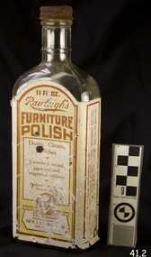 Flagstaff Hill Maritime Museum and Village
Container - Glass Bottle, W T Rawleigh, 1920s
W.T. Rawleigh's & Co. manufactured various household products in a factory in Collins Place, Melbourne, between 1930 and 1935. The W.T. Rawleigh Company was an American company started by William Rawleigh in 1889. The company expanded to both Canada and Australia with the Rawleigh company specialising in medicines, remedies, food additives, cleaning products and toiletries. Due to increased demand, Rawleigh’s required a larger factory and thus built the factory in Dawson Street Brunswick Victoria and by 1950 the factory had been extended to include 98,000 square feet of floor space. The Brunswick factory ceased production in the late 1970s and manufacturing was moved to New South Wales. During the peak of production, more than 200 people were employed in the Brunswick factory and several independent sale representatives sold their products door-to-door throughout the country. The ‘Rawleigh’s man’ was a regular door-to-door salesman of inter war and post-war suburban Melbourne. Rawleigh’s products are still in production today.A significant item as it gives a snapshot into domestic life and social norms of the pre and post war period in Melbourne and throughout Australia and New Zealand. The item demonstrates how selling house hold products door to door was pioneered in Australia by the Rawleigh’s company in the early 1900s and is still in existence today.Bottle, glass, narrow neck rectangular base with metal screw top.label of Rawleigh's Furniture Polishflagstaff hill, warrnambool, flagstaff hill maritime museum, shipwreck coast, flagstaff hill maritime village, great ocean road, bottle, rawleigh's furniture polish, furniture polish, rawleigh's, cleaning -
 Eltham District Historical Society Inc
Photograph, Liz Pidgeon, Heritage Excursion; East of Eltham, 6 Sep 2014, 20 May 2017
Newsletter No. 218, September 2014 September Excursion - East of Eltham Walk In Newsletter No. 197, March 2011, there was a brief history of Crown Allotment 15 Section 5 Parish of Nillumbik (CA 15) a parcel of land of a quarter of a square mile extending from Eucalyptus Road to Reynolds Road at the eastern extremity of Eltham. From the 1940s it was known as Stokes orchard. In later years it has been subdivided for residential purposes but leaving significant areas as power line and water supply reserves and bushland reserves that are habitat for the threatened For our excursion on 6th September we intend to walk through CA 15 to a bushland reserve east of Reynolds Road. The walk will traverse the boundary between suburban Eltham and the non-urban areas to the south and east. This is a pleasant walk through residential areas and bushland. Along the way we will discuss the early and more recent history of CA 15 as well as local natural history and geology. This walk is about 3.5 km in length and will take 2 to 2.5 hours. It will start at 2pm at the corner of Eucalyptus Road, Pitt Street and Nyora Road.Born Digitaleltham east, eltham district historical society, heritage excursion, activities, nyora road, reynolds road, gum tree road reserve, diosma road, stokes orchard, eucalyptus road -
 Eltham District Historical Society Inc
Photograph, Liz Pidgeon, Heritage Excursion; East of Eltham, 6 Sep 2014, 20 May 2017
Newsletter No. 218, September 2014 September Excursion - East of Eltham Walk In Newsletter No. 197, March 2011, there was a brief history of Crown Allotment 15 Section 5 Parish of Nillumbik (CA 15) a parcel of land of a quarter of a square mile extending from Eucalyptus Road to Reynolds Road at the eastern extremity of Eltham. From the 1940s it was known as Stokes orchard. In later years it has been subdivided for residential purposes but leaving significant areas as power line and water supply reserves and bushland reserves that are habitat for the threatened For our excursion on 6th September we intend to walk through CA 15 to a bushland reserve east of Reynolds Road. The walk will traverse the boundary between suburban Eltham and the non-urban areas to the south and east. This is a pleasant walk through residential areas and bushland. Along the way we will discuss the early and more recent history of CA 15 as well as local natural history and geology. This walk is about 3.5 km in length and will take 2 to 2.5 hours. It will start at 2pm at the corner of Eucalyptus Road, Pitt Street and Nyora Road.Born Digitaleltham east, eltham district historical society, heritage excursion, activities, nyora road, reynolds road, gum tree road reserve, diosma road, stokes orchard, eucalyptus road