Showing 864 items matching "surveyor"
-
 Warrnambool and District Historical Society Inc.
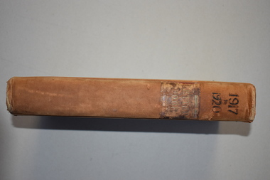
Letter book 7, 1917-1920, 1917
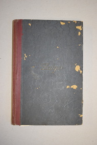
This letter book contains handwritten letters, sketch maps and plans and dates from 1917 to 1920. It comes from the office of John William Crawley Junior, an engineer, architect and surveyor in private practice in Warrnambool and also the engineer for the Shire of Warrnambool from 1895 to 1935. His father, brother and son were also engineers and worked in that capacity or as Shire Secretary for the Shire of Warrnambool, with the Crawley family recording 132 years of service with the Shire of Warrnambool. The Shire existed from 1863 to 1994. The letter book was passed on to John Crawley’s son, Rolf, the engineer for the Shire of Warrnambool from 1935 to 1968. The letter book then came into the possession of Michael Hand who took over the private surveying business of Rolf Crawley in Warrnambool. The Warrnambool and District Historical Society then acquired this letter book, along with other Crawley ledgers, from the Michael Hand estate. This letter book is of considerable significance as it contains letters, plans and maps drawn up John William Crawley Junior, the engineer for the Shire of Warrnambool for 40 years. It will be very useful for research. This is a hard cover book of 745 pages. It has leather trim on the cover edges and the spine with gold lettering on the spine. The leather covering is scuffed and torn. The inside covers have a mottled blue lining. The book contains maps, plans and handwritten letters and has an alphabetical index at the beginning of the book. Most of the pages have been water-stained. ‘7 Private’ ‘Letter Book 1917 to 1920’john william crawley junior, warrnambool, rolf crawley, warrnambool, shire of warrnambool -
 Warrnambool and District Historical Society Inc.
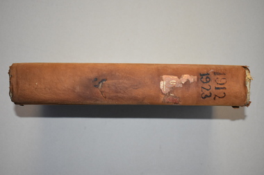
Ledger 10, Letters 1912 1923, 1912
This letter book contains letters and maps and dates from 1912 to 1923. It came from the office of John William Crawley Junior, an engineer, architect and surveyor in private practice in Warrnambool and also the engineer for the Shire of Warrnambool from 1895 to 1935. Hs father, brother and son were also engineers and worked in that capacity or as the Shire Secretary in the Shire of Warrnambool, with the Crawley family recording a total of 132 years of service to the Shire. The Shire of Warrnambool existed from 1863 to 1994. The letter book was passed on to John Crawley’s son, Rolf who was the engineer for the Shire of Warrnambool from 1935 to 1968. It then passed into the possession of Michael Hand who took over the private surveying practice of Rolf Crawley in Warrnambool. The Warrnambool and District Historical Society acquired the letter book, along with several other Crawley ledgers, from the estate of Michael Hand. This letter book is of considerable interest as it contains letters and maps drawn up by John William Crawley, a Shire of Warrnambool engineer for 40 years. It will be helpful to researchers. This is a black hard cover letter book with brown binding on the cover edges and the spine. Parts of the cover have been worn away. The spine once had gold lettering but this is mostly worn away. The book has 743 pages of handwritten letters and maps and an alphabetical index at the front. The pages are water stained.‘Letter Book 1912, 1923’john william crawley junior, warrnambool, rolf crawley, warrnambool, shire of warrnambool -
 Warrnambool and District Historical Society Inc.
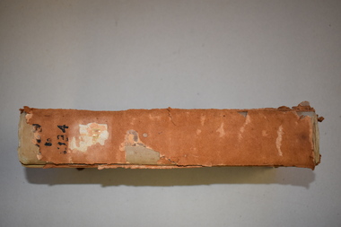
Letter book 15, 1920s
This letter book contains letters, sketch maps and plans and dates from 1929 to 1934. It came from the office of John William Crawley Junior, an engineer, surveyor, and architect in private practice in Warrnambool and also the engineer for the Shire of Warrnambool from 1895 to 1935. His father, brother and son were also engineers, working in that capacity or as Shire Secretary for the Shire of Warrnambool, with the Crawley family recording a total of 132 years of service to the Shire. The Shire of Warrnambool existed from 1863 to 1994. The letter book was passed on to John Crawley’s son, Rolf who was the engineer for the Shire of Warrnambool from 1935 to 1968. It then came into the possession of Michael Hand who took over the private surveying business of Rolf Crawley in Warrnambool. The Warrnambool and District Historical Society acquired the letter book, along with several other Crawley ledgers, from the estate of Michael Hand. This letter book is of considerable importance as it contains letters and maps from the late 1920s and 1930s and was compiled by John Crawley Junior, an engineer in the Shire of Warrnambool for 40 years. It will be a useful research tool. This is a hard-cover letter book of 1005 pages. It contains an alphabetical index at the front, handwritten letters, sketch maps and plans and some loose sheets. It has brown leather binding on the corners of the cover and on the spine but the spine covering is completely detached. The gold lettering on the spine is now almost completely obliterated. The cover is scuffed and torn. ‘Private Book’ ‘1929 to 1934’ john william crawley junior, warrnambool, rolf crawley, warrnambool, shire of warrnambool -
 Warrnambool and District Historical Society Inc.
Ledger, Crawley, 1919
This ledger contains accounts and payment details and dates from 1919 to 1925. It came from the office of John William Crawley Junior, an engineer, surveyor and architect in private practice in Warrnambool and also the engineer for the Shire of Warrnambool from 1895 to 1935. His father, brother and son were all engineers and worked in that capacity or as the Shire Secretary of the Shire of Warrnambool, with the Crawley family recording a total of 132 years of service to the Shire. The Shire of Warrnambool existed from 1863 to 1994. This accounts book was passed on to John Crawley’s son, Rolf who was the engineer for the Shire of Warrnambool from 1935 to 1968. It then came into the possession of Michael Hand who took over the private surveying business of Rolf Crawley in Warrnambool. The Warrnambool and District Historical Society acquired the accounts book, together with several other Crawley ledgers, from the estate of Michael Hand. This book is of considerable interest as it contains details of the 1920s accounts and payments recorded by John William Crawley Junior, the engineer for the Shire of Warrnambool for 40 years. It will be useful for researchers.This is a black hard cover book of 132 pages. It has red binding on the corners of the cover and on the spine. There is gold lettering on the spine. The book has a brown mottled pattern inside the cover. The pages are ruled with red and blue lines and contain invoices and payment statements.‘Shire Office Warrnambool’ ‘J.Wm. Crawley & Son Warrnambool’ john william crawley junior, warrnambool, rolf crawley, warrnambool, shire of warrnambool -
 Warrnambool and District Historical Society Inc.
Ledger, Copies of specifications, 1927
This ledger contains copies of specifications and accounts dating from 1927 to 1935 with some entries dating from 1950 and 1951. The accounts were issued originally from the office of John William Crawley Junior, a surveyor, architect and engineer in private practice in Warrnambool and also the engineer for the Shire of Warrnambool from 1895 to 1935. His father, brother and son were also engineers, working in that capacity or as Shire Secretary for the Shire of Warrnambool, with the Crawley family recording a total of 132 years of service to the Shire. The Shire of Warrnambool existed from 1863 to 1994. The ledger was passed on to, and used by John Crawley’s son, Rolf, the engineer for the Shire of Warrnambool from 1935 to 1968. It then came into the possession of Michael Hand who took over the private practice of Rolf Crawley in Warrnambool. The Warrnambool and District Historical Society acquired the ledgerThis ledger is of interest as it contains accounts connected to the work of John and Rolf Crawley, Shire of Warrnambool engineers in the early to mid 20th century. The information in the ledger will be of great interest to researchers.This is a hard cover book of 100 pages. The book is bound on the spine with dark red tape. Some of the pages are unused. The pages are ruled with red and blue lines and there are some loose pages. The cover is torn in some places.‘Ledger’ ‘Copies of Specifications’ john william crawley junior, warrnambool, rolf crawley, warrnambool, shire of warrnambool -
 Warrnambool and District Historical Society Inc.
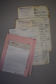
Documents, Rolf Crawley, Warrnambool, Warrnambool Race Course, 1920s and 30s
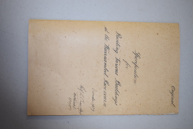
These documents deal with improvements in the 1920s and 30s (drainage, painting etc) to the Warrnambool Race Course. In 1854 the Warrnambool Racing Club was established and the first race meeting on the present day Warrnambool Race Course was held in 1858. These documents came from the office of Rolf Crawley, an engineer, architect and surveyor in private practice in Warrnambool and the engineer for the Shire of Warrnambool from 1935 to 1968. His grandfather, father and uncle were also engineers and worked in that capacity or as the Shire Secretary for the Shire of Warrnambool, with the Crawley family recording a total of 132 years of service to the Shire. The Shire of Warrnambool existed from 1863 to 1994. The documents came into the possession of Michael Hand who had taken over the private surveying business of Rolf Crawley in Warrnambool. The Warrnambool and District Historical Society acquired these documents and other Crawley material, from the Michael Hand estate. These documents are of considerable interest as they concern the Warrnambool Race Course improvements in the 1920s and 30s and come from the office of Rolf Crawley of Warrnambool. These are seven documents relating to the Warrnambool Race Course: .1 A manila folder with a handwritten title on the front cover and typed and printed material inside .2 A sketch map of the Warrnambool Race Course produced on heavy quality white paper. .3 Hand-drawn material on the underground drains on the Warrnambool Race Course produced on heavy quality white paper .4 & .5 Longitudinal section of the main drain, Warrnambool Race Course, produced on heavy quality white paper .6 Section of the drain near the fence and culvert of the Warrnambool Race Course produced on heavy quality paper .7 A piece of paper giving the chainage of the Warrnambool Race Course in red handwriting. warrnambool race course, rolf crawley, warrnambool -
 Eltham District Historical Society Inc
Folder, Armstrong
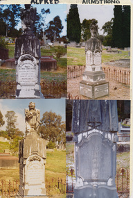
Alfred Armstrong Armstrong, Alfred, Eltham is a native of Somerset, England, born in 1825, and was employed under Mr. Mark Isambard Kingdom Brunel as a civil engineer prior to his coming out to Melbourne in 1852. He first visited Beechworth, but returning to Melbourne took contacts at Essendon and Gisbourne for forming and metalling the road. He afterwards purchased property at Eltham, where is at present mining, surveyor, inspector of mines, and mining registrar for the St Andrew’s division of the Castlemaine mining district. Mrs Armstrong, to whom he was married in 1854, at St Paul’s Church, Melbourne, died on 27th March, 1887. from "Victoria and its Metropolis: Past and Present" written in 1888 by Alexander Sutherland. Chapter 19, "The Upper Yarra District" pages [402] - 415. Includes descriptions of some townships and short biographies of local residents. Page 405 Folder of information on Alfred Armstrong, Eltham and Kangaroo Groundalfred armstrong, ada gertrude armstrong, arthur reynolds stockwood armstrong, arthur vivian harrison, eltham cemetery, gravestones, laura augusta harrison (nee armstrong), margaret armstrong, mary armstrong, thomas armstrong -
 City of Moorabbin Historical Society (Operating the Box Cottage Museum)
Newsletter, City of Moorabbin Historical Society No.1 Vol. 4 January 1964, City of Moorabbin Historical Society Newsletter No. 1 Vol. 4 January 1964, 1964
This is Newsletter No 1 Vol. 4 produced in January 1964 by Mr T. A. Sheehy CMHS for members and visitors. Topic Australia Day 1803, Surveyor C.Grimes and Captain C Robbins Expedition Port Phillip Bay The Aims of the CMHS are ‘to record the history of the City, and register something of the Australian Atmosphere, which the necessary speed-up in post-world-war two (WW11) immigration has caused to be lost; to produce a magazine at regular intervals, featuring the work of pioneers and the changing Australian scene; to work constantly with a long range view towards building a hall where records and exhibits can be housed’ (1961) The Original Newsletters reflect the history and heritage of the former City of Moorabbin — derived from Mooroobin, ‘a resting place’ in the Bunurrung spoken language. In 1994, the City of Moorabbin was integrated into the Cities of Bayside, Glen Eira, Kingston and Monash. This is Newsletter No.1 Vol. 4 of the CMHS January 1964 CMHS obtained a Kingston City Council Community Grant 2016 for the digitization and preservation of these Original CMHS Newsletters commenced in 1961 1 x Foolscap paper printed on 2 sides folded for 4 pages CITY OF MOORABBIN HISTORICAL / SOCIETY / VOLUME 4 ( Number 1 ) / NEWSLETTER January 1964city of moorabbin historical society 1961, sheehy t.a., harvey l, ashley r, moorabbin city council, standard newspapers ltd., grimes charles, robbins charles, port phillip bay expedition 1803,, -
 Otway Districts Historical Society
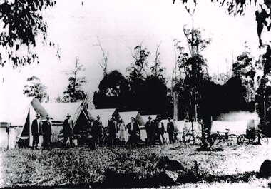
Photograph, Knox Collection, Survey camp for Colac-Beech Forest railway, 1901, 1901
Plans for a rail connection between Colac and Beech Forest had been drawn up in 1884 and 1889 but proofed inconclusive because of the enormous cost involved in building a railway in such difficult terrain. Because of the financial depression in the early 1890s such expenditure went of hold. Towards the end of the decade planners recognised that a narrow gauge could be a viable alternative and it was taken up by the community, Parliamentary representatives and the government, although Victorian Railways administration was against the idea. This was overridden. The 1898 Parliament approved a 2 foot 6 inch gauge from Colac to Beech Forest although strict financial limits were set. The route was to be the most direct and the infrastructure the most basic. Construction began in 1900 entailing very steep grades and myriad curves until it finished in 1902. Surveyors and their assistants came before and during the track laying for the whole distance.B/W. Survey camp for the Colac-Beech Forest railway in 1901, showing nine tents, ten men including a cook, survey instruments, and three bicycles. Note the cooking fire on the right.colac: beech forest; railways; survey; -
 Surrey Hills Historical Society Collection
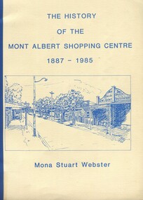
Book, Box Hill Historical Society et al, The history of the Mont Albert Shopping Centre, 1986
Born in 1900, Mona was the daughter of Florence Jane McDowall Stuart (1867-1936) and George Hudson Grant (1864-1910) who married in 1899. He was a surveyor and they lived in Albany Crescent, Surrey Hills. Her full name was Jessie Mona Stuart Grant and she had a sister Mollie. In 1924 she married Clarence William Willoughby Webster (1895-1980) - SERN 33286. Clarence was born in Thorpedale where his father was a teacher. He was living in View Street Mont Albert and was a law student when he enlisted on 3 October 1916. After discharge on 10 May 1919, Clarence returned to his studies. He joined a legal firm in the city which became Pearce & Webster (later Pearce Webster Dugdale). Mona and Clarence lived in Surrey Hills and Mont Albert in a number of homes for the remainder of their lives.A history of the Mont Albert Shopping Centre in Hamilton Street, Mont Albert, including the early land use, and a chronology of shop owners. Index, photos., 39p. Compiled by local resident, Mona Webster.On front cover: top RH corner "Kay Kirkwood/98995158"phoenix park estate, mont albert, hamilton street, (mr) - mckerdy, (mr) - andrew, (mr) - dunn, (lady) emma hamilton, railways, churchill street, surrey hills golf club, (mrs) mona webster -
 Surrey Hills Historical Society Collection
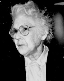
Photograph, Mrs Mona Webster
Born in 1900, Mona was the daughter of Florence Jane McDowall Stuart (1867-1936) and George Hudson Grant (1864-1910) who married in 1899. He was a surveyor and they lived in Albany Crescent, Surrey Hills. Her full name was Jessie Mona Stuart Grant and she had a sister Mollie. In 1924 she married Clarence William Willoughby Webster (1895-1980) - SERN 33286. Clarence was born in Thorpedale where his father was a teacher. He was living in View Street Mont Albert and was a law student when he enlisted on 3 October 1916. After discharge on 10 May 1919, Clarence returned to his studies. He joined a legal firm in the city which became Pearce & Webster (later Pearce Webster Dugdale). Mona and Clarence lived in Surrey Hills and Mont Albert in a number of homes for the remainder of their lives. A black and white portrait of an older lady wearing round wire-rimmed glasses.writers, authors, view street, surrey hills, mont albert, victoria crescent, mrs mona webster, mr clarence webster, jessie mona stuart grant (miss), jessie mona stuart webster (mrs) -
 Bendigo Military Museum
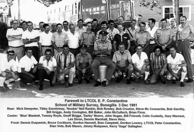
Photograph - RASvy Serving and Retired Personnel Farewelling LTCOL Peter Constantine AM at Bonegilla, VIC, 1981
This is a group photograph of RASvy serving and retired personnel at a farewell to LTCOL Peter Constantine AM, at the School of Military Survey, Bonegilla, VIC, 3rd December 1981. LTCOL Constantine was the CO of the Army Survey Regiment from 1975 to 1976 and CO of School of Military Survey (SMS) from 1976 to his retirement in January 1982. The contingent of serving and retired personnel from units across Australia travelled in civilian attire by bus to Bonegilla for the occasion culminating with a farewell dinner. Most personnel appearing in uniform were instructional staff from the SMS. LTCOL Constantine was one of RASvy’s most revered officers in this era, with 32 years of meritorious service as a leader on active duty in Vietnam in 1969 and the commanding officer of the Regiment and School. His memoirs of active duty in Vietnam ‘Surveyor - Printer Behind the Lines’ was published in 2022.This is a group photograph of RASvy serving and retired personnel at a farewell to LTCOL Peter Constantine AM, at the School of Military Survey, Bonegilla, VIC, 3rd December 1981. The photograph with annotated personnel was printed on photographic paper and is part of the Army Survey Regiment’s Collection. The photograph was scanned at 600 dpi. Serving and retired personnel are identified in the footnotes at the bottom of the photo. royal australian survey corps, rasvy, army survey regiment, army svy regt, fortuna, asr -
 Federation University Historical Collection
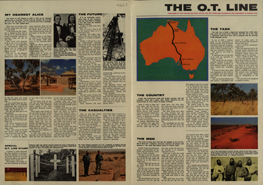
Newspaper, Overland Telegraph Centenary, 1972, 1972
.1) Overland Centenary Supplement to The Australian. Six pages of information and images including the Roper River Camp, First Telegraph Pole at Port Darwin, Route of the Overland Telegraph, Australian Telecommunications Development Association, Alice Springs, Frew's Ponds. Charles Todd, Alice ToddFrank Kraegen, Pony Express. .2) 'The O.T. Line' - four page coloured news shhet published of by the Australian Post Office for the Overland Telegraph Line Centenary, 22 August 1972. Includes articles and images such as J.A.G. Little (Darwin Poatmaster), Robert Patterson, Charles Todd, A.J. Mitchell (surveyor), Maps of the sections (Begot's contract, Central Sections, Darwent and Dalwood contract, Patterson contract), planting of the first pole at Darwin, Roper River Camp, Charles Todd, Alice Todd, Alice Springs Repeater Station, Grave of Kavenagh, Roper River, Frank Kraegem, Maryvale station.roper river camp, telegraph pole, port darwin, overland telegraph route, australian telecommunications development association, alice springs, frew's ponds, charles todd, alice todd, frank kraegen, pony express -
 Orbost & District Historical Society
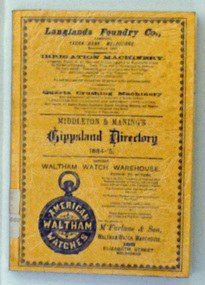
book, E-Gee Printers, Middleton & Manning's Gippsland Directory 1884-5, 1983
The 1884-1885 Directory was the first year of publication for the Middleton and Manning's Gippsland Directory. It was first published by Ale Middleton and Francis Beresford Manning. Beginning with advertisements from local businesses of the time, this is followed by a short gazetteer of places around the region, as well as general information on the districts of Gippsland. The main part of the Directory consisting of about 100 pages, is the Alphabetical Directory. Listed alphabetically by surname under each region, this lists heads of household (mostly male but there are a few females mentioned), together with their occupation and address.The list includes farmers, labourers, coach painters, dairywoman, teacher, saddler, brickmaker, merchant, laundress, hotel keeper, minister of religion, dressmaker, grocer, grazier, gasfitter, seedsman, coachbuilder, engineer, auctioneer, upholsterer, fowler, journalist, surveyor, musician, traveller, watchmaker, solicitor, restaurant keeper, blacksmith and miner. It is not just "business owners" mentioned in this directory it is everyone. (ref Gen E Books)This is a useful reference tool.A 135 pp soft covered book with an orange/brown cover. On the front cover in black print is a range of advertisements or local businesses. It contains a short gazetteer of places in the region as well as general information on the districts of Gippsland. The main part of the directory is an alphabetical list of the household , with occupations and addresses. This is a reprint of the original.directory-gippsland book-middleton-manning-1884-5 -
 Warrnambool and District Historical Society Inc.
Letter book, 1933
This letter book contains letters that date from 1933 to 1936. It came originally from the office of John William Crawley Junior, an engineer, architect and surveyor in private practice in Warrnambool and also the engineer for the Shire of Warrnambool from 1895 to 1935. His father, brother and son were all engineers and worked in that capacity or as the Shire Secretary, for the Shire of Warrnambool, with the Crawley family recording a total of 132 years of service to the Shire. The Shire of Warrnambool existed from 1863 to 1994. The letter book was also used by John Crawley’s son, Rolf who took over the job of engineer at the Shire of Warrnambool in 1935 and held the position until 1968. The book then came into the possession of Michael Hand who took over the private surveying practice of Rolf Crawley in Warrnambool. The Warrnambool and District Historical Society acquired the letter book, along with several other Crawley ledgers, from the Michael Hand Estate. This letter book is of considerable importance as it contains letters written by John Crawley Junior and Rolf Crawley, both engineers for the Shire of Warrnambool over the years covered by the letter book. It will be very useful to researchers. This is a hard cover book of 1000 pages. Only half of the pages have been used and there are some loose sheets. The book is bound on the cover corners and on the spine with buff-coloured leather. The pages contain an alphabetical index and handwritten letters. Some pages are water-stained. ‘Letter Book 1933 Shire’john william crawley, warrnambool, rolf crawley, warrnambool, shire of warrnambool -
 Warrnambool and District Historical Society Inc.
Letter book, J & R Crawley, 1934
This letter book contains letters, sketch maps and plans and dates from1934 to 1936. It originally came from the office of John William Crawley Junior, an engineer, surveyor and architect in private practice in Warrnambool and also the Shire Engineer for the Shire of Warrnambool from 1895 to 1935. His father, brother and son were also engineers and worked in that capacity or as the Shire Secretary for the Shire of Warrnambool, with the Crawley family recording a total of 132 years of service to the Shire. The Shire of Warrnambool existed from 1863 to 1994. The letter book was also used in the private practice of John Crawley’s son, Rolf who was the engineer for the Shire of Warrnambool from 1935 to 1968. The letter book then came into the possession of Michael Hand who took over the private surveying business of Rolf Crawley in Warrnambool. The Warrnambool and District Historical Society acquired the letter book, along with several other Crawley ledgers, from the estate of Michael Hand.This letter book is of considerable significance as it contains letters written by John Crawley and Rolf Crawley who were in an engineering, surveying and architects private practice in Warrnambool over the time covered in the book. It will be very useful to researchers. This is a hard cover book of 1000 pages but only 354 pages have been used. The cover is bound at the corners and on the spine with buff-coloured leather. The book contains an alphabetical index, handwritten letters, sketch maps and plans. ‘Private Letter Book 1934- 19.’ ‘R.L./J. W. Crawley Private’ john william crawley junior, warrnambool, rolf crawley, warrnambool, shire of warrnambool -
 Puffing Billy Railway
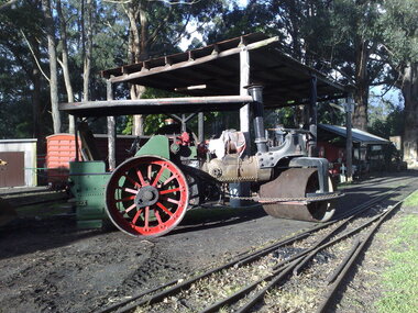
Vehicle - Aveling & Porter 11629, South Melbourne City Council Aveling & Porter 10 ton Steam Roller, 1923
Built by Aveling & Porter Ltd., Rochester, Kent, England Builder’s Number 11629 of 1923 Weight 10 Tons Used by the South Melbourne Council in road construction between 1926 and 1963 Aveling and Porter was a British agricultural engine and steam roller manufacturer. Thomas Aveling and Richard Thomas Porter entered into partnership in 1862, developed a steam engine three years later in 1865. The company became the largest manufacturer of steam rollers in the world. Service History : Title: City Surveyor's report Creator: Johnson, A.L Publisher: Prahran City Council Date: 1921 .... The 10-ton steam roller worked 302 days, the Aveling and Porter 12½-ton roller worked 211 days while the Garrett steam wagon continues to carry tar and road materials. city of prahran annual reports 1912-1913 http://www.stonnington.vic.gov.au/files/assets/public/history/city-of-prahran-annual-reports-1912-1913.pdf Industrial Steam Roller - Road Construction, South Melbourne, Victoria, Australia Aveling & Porter 10 ton Steam Roller with roof and rear tool box Builders Number 11629 Aveling & Portersouth melbourne, puffing billy, steam roller, aveling and porter, puffing billy museum, road construction, road steam -
 Port Fairy Historical Society Museum and Archives
Photograph
The land was bought in 1853 by John Smith and he built the house. The house was offered for sale in 1866 when George Barnacle bought it and named it 'Warwick Cottage' after his birth place. it was offered to short term tenants such as the surveyor Creed, Miss Boes a dressmaker and O'Doherty the Catholic school teacher. In 1874 Dr Rastrick was a tenant and in 1878 it was occupied by the grocer William Searle and his sister a dressmaker. Barnacle offered the cottage for sale in October 1885 advising that the iron roofed stone cottage , 4rooms, detached kitchen and outhouses had been previously occupied by W.C.Uncles and at that time William Muhleg Carpenter. It ultimately sold privately to Miss Beatty and she continued to rent it to tenants. James Kilbride was the tenant in 1887-88. The cottage was sold in 1888 to Isaac Smale. The house continued its tradition of housing dressmakers with Mrs Barby carrying on that profession in the 1940's,50's and 60's. Coloured photographcottage, building, home, house, 77 cox street, warwick cottage -
 Wodonga & District Historical Society Inc
Functional object - Seal - Police Office, Belvoir
This seal was used for official police and court documents by the Belvoir Police Office.The initial land survey for the city now known as Wodonga was first undertaken in 1852 by Thomas Wedge - Assistant Surveyor. The new township was called "Belvoir" and was proclaimed by that name in 1852 and again in 1861. The first sale of land in Belvoir was held at Wangaratta on April 28, 1854, when all the allotments surveyed by Thomas Wedge (excepting those set apart for reserves, government and public areas) were offered at auction. Following representations by the Postmaster General on June 23, 1869, the Governor in Council, on July 12, 1869, approved of its Aboriginal name "Wodonga" being restored. The seal was found at the Yackandandah Courthouse by the Circuit Judge, the late Mr. Jim Humphrey. As the Wodonga Historical Society was in recess at that time, the seal was held in trust by the North-East Historical Society in Wangaratta. It was donated to the Wodonga Historical Society in 1987.This item was the official seal of the Belvoir Police office from the beginning of the European settlement of the modern day city of Wodonga, then know as Belvoir. It is one of the earliest relics of that period of history, until its name was changed in 1869.Wood and metal seal bearing the official emblem of the Police Office Belvoir. It would have been used to apply a wax seal to official documents. The seal is mounted in a timber and glass case so that the imprint of the seal can be seen reflected in a mirror mounted in the base of the box.Around the edges of the seal "POLICE OFFICE / BELVOIR"belvoir police, official seal, history wodonga -
 Wodonga & District Historical Society Inc
Map - Australia Shewing the Tracks of the Late Explorers
Charles George Eastland Platts arrived in South Australia on 22 March 1839, and soon after established his business in Adelaide. He became Adelaide’s first bookseller. It was known as Platts’ Library but was also a bookshop and stationer. His business was also used as a postal receiving house. Platts died on 14 November 1871. Boyle Travers Finniss (18 August 1807 – 24 December 1893) had an early career in the British Military before selling off his commission in 1835. He was appointed assistant surveyor to Colonel William Light in South Australia. He then had several roles in public service. Finniss was the first premier and Chief Secretary South Australia, serving from 24 October 1856 to 20 August 1857. In 1864 he was appointed as the Government Resident of the Northern Territory. He was filling this role at the time when the map was produced and is acknowledged on the map.This is a very early map documenting the exploration and opening up of Australia.Map of Australia and part of Indonesia. Part coloured with tracks of 15 explorers including Eyre, Stuart, Leichhardt and Burke and Wills with notes and some details of latitude and longitude. Relief relating to the major mountain ranges is indicated. At the bottom of the map is a key to the explorers and a list of the counties in the different states. Top left side of map has small sketch of the Platts (publisher) building at the corner of King William Street.Map of Australia shewing the tracks of late explorers into the interior and across the continent together with their discoveries map/ projected, compiled and drawn by O.W.O. Bennett Most Respectfully Dedicated to LIEUT. COL. BOYLE TRAVERS FINISS Government Resident of the Northern Territory of SOUTH AUSTRALIAexplorers -- australia -- maps, rare maps australia -
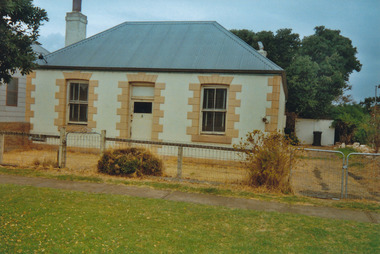
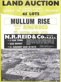 Ringwood and District Historical Society
Flyer, Land Auction Advertisement, Mullum Rise, Ringwood - 1970
Double sided leaflet with aerial view of part of Ringwood showing subdivision site, terms of sale, layout of streets and allotments, and summary of local features and services. Additional printout of map with handwritten real estate sales notations includes prices for some allotments.Land auction, Saturday, 10th October (1970). 45 home sites. Subdivision includes Mullum Mullum Road, Hugh Street, Rollington Drive, Cassandra Court, and Jeffrey Drive. Surveyors - R.G. Lee Pty. Ltd., 6 Davis Street, Richmond. Agents - N.R. Reid & Co., 173 Coleman Parade, Glen Waverley, (Telephone) 560 0355 A.H. 560 0361 and Safeway Centre, Boronia Road, Boronia, (Telephone) 762 1022 A.G. 795 2887, also at East Malvern and Mount Waverley. -
 Orbost & District Historical Society
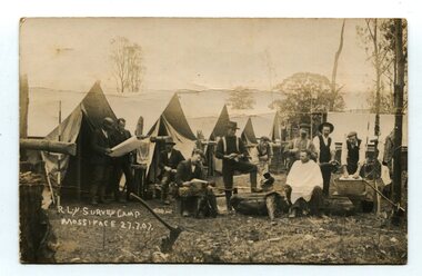
black and white photograph, July 27 1907
This is a camp of survey workers surveying the railway line . They were camped at Mossiface in 1907. It has been sent as a postcard - "Dear Miss Ross, Just a card, hoping you are well etc, trust you have not forgotten our trip. I forgot to get the name of the street in Hobart of Mr Benjamin or Temple?????? Sufficient. Yours sincerely H.R. Gordon". It has been dated September 30th 1907. There had been men surveying in East Gippsland from the late 19th century. Railway surveyors advocated two lines beyond Bairnsdale – one via Bruthen and the Tambo Valley to Omeo, the other via Swan Reach and Colquhoun to Orbost, then on to Bendoc and the border. With all the argument and feuding between the warring factions, by the end of 1891, the Parliamentary Railways Standing Committee gave up in despair of trying to reach any agreement and abandoned the idea altogether. Finally, with all problems solved, the first sod was turned at Mossiface on 9.1.1912, the government sticking to the original route in the 1890 survey .This is a pictorial record of a surveyors' camp in the early 20th century. The Bairnsdale to Orbost Railway was a significant contributor to the economy of Orbost until it closed.A black / white photograph / postcard of a group of men at a campsite. In the background is a row of tents. on the right side is a clothes line with several sheets hung over it. Two men are studying a map or chart; one man is sitting with a cloth around his shoulders while another is standing behind him cutting his hair; one man is washing cloth in a tin tub; another appears to be stirring a pot; others are sitting reading or just observing.on front - handwritten is " R.L.Y.S. SURVEY CAMP MOSSIFACE 27.7.07" on back is a letter - "Dear Miss Ross.............yours sincerely ????? Gordon"surveying-railway east-gippsland-railway mossiface-survey-camp -
 Warrnambool and District Historical Society Inc.
Document, Letters & Minutes, 1960s
These documents contain information about the Warrnambool Racing Club in the 1960s. Race meetings were held in Warrnambool as early as 1848, a few months after the first white settlers arrived. The Warrnambool Racing Club was formed in 1854 and the present day racecourse was first used in 1858. In 1872 the well-known Warrnambool Grand Annual Steeplechase was first held. These documents came from the office of Rolf Crawley, a surveyor, architect and engineer in private practice in Warrnambool and also the engineer for the Shire of Warrnambool from 1935 to 1968. His grandfather, father and uncle were also engineers, working in that capacity or as the Shire Secretary for the Shire of Warrnambool, with the Crawley family recording a total of 132 years of service to the Shire. The Shire of Warrnambool existed from 1863 to 1994. These documents came into the possession of Michael Hand who took over the private surveying practice in Warrnambool of Rolf Crawley. The Warrnambool and District Historical Society acquired these documents, along with several ledgers and other Crawley memorabilia, from the estate of Michael Hand. These documents are of interest as they contain much information on the Warrnambool Racing Club and will be of assistance to researchers.This is a collection of documents relating to the Warrnambool Racing Club. They are typewritten letters and Minutes summaries. Some are copies and there are two cards giving notice of meetings. rolf crawley, warrnambool, warrnambool racing club, shire of warrnambool -
 Bendigo Historical Society Inc.
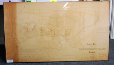
Map - CONTOUR PLAN OF THE GOVERNMENT CAMP SANDHURST 1854, 1994
Contour map (copy) of the Government Camp Sandhurst, 1854. Map is mounted on coreflute and laminated. Written in bottom righthand corner 'Contour Plan of the Government Camp, Sandhurst. Dec 1854. Signed by Richard Larritt, Assistant Surveyor, 11th December 1854.' Shown on map: Pall Mall, Bendigo Creek, Commissioner's Gully, View Place (now View Street), Post Office, Bank of Victoria, District Surgeon, Sandhurst Fire Brigade, Police Hospital, Flagstaff, Gold Office, License Shed, Military Barracks, Stables, Commissioner's Buildings, Police Office. Old Cemetery, Garden. Reference on righthand side: 'Stone or brick buildings are tinted in crimson. Wooden buildings tinted in Indian Ink. Tents and other temporary structures tinted in Burnt Sienna.' Scale of Chains, on bottom of map. Sticker on bottom left hand corner and back of map ' Presented by Survey and Mapping, Victoria, 7th Octber, 1994'.map, bendigo, government camp, pall mall, bendigo creek, commissioner's gully, view place (now view street), post office, bank of victoria, district surgeon, sandhurst fire brigade, police hospital, flagstaff, gold office, license shed, military barracks, stables, commissioner's buildings, police office. old cemetery, garden. , survey and mapping victoria. sandhurst, bendigo. -
 Melbourne Tram Museum
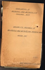
Document - Personal Papers, Melbourne & Metropolitan Tramways Board (MMTB), "Consolidation of Melbourne and Metropolitan Tramway Acts, 1957 - 1958
Brown coloured file folder marked "Consolidation of Melbourne and Metropolitan Tramway Acts - Documents prepared by Melbourne and Metropolitan Tramways Board March 1957" with a sub heading "Chief Surveyors Copies - 2 Sets". Contains may typed and handwritten notes and draft documents in relation to MMTB Act of 1958, including explanatory paper, drafts, annotations, correspondence drafts, files notes, checking documents, correspondence with the Government, MMTB Secretary, revised schedules showing cable trams and how they were closed, track removals etc, tramways authorised by not constructed, existing tramways, descriptions of tramways. Includes drafts of letters to Mr. R. C. Normand, Director of Statutory Consolidation, Parliamentary Draftsman's Office. Would appear Mr. McComb did a lot of work on this project in sorting out the schedules and what the various Act provisions for them were. Includes two MMTB envelopes address to Mr. McComb at the Victoria Parade Offices Fitzroy.trams, tramways, mmtb, acts of parliament, cable trams, tramways, closure -
 Bendigo Military Museum
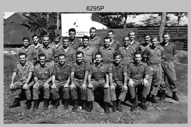
Photograph - A Section, 1st Topographic Survey Troop, Nui Dat, Vietnam, 1969
This is a photograph of A Section, 1st Topographic Survey Troop taken at Nui Dat, Vietnam in 1969. A nominal roll of personnel and their trade as of the 30th of September 1969, accompanies this photo. Their trades in this photo were as follows - Surveyors Topographic: WO1 Darby Munro, SGT Paddy Strunks, SGT Graeme Birrell, CPL Brian Knight, CPL Colin Laybutt, SPR Roderick Gilbert and SPR Rodney Offer. Draughtsmen Topographic: SGT Terrance Linz, CPL Robert Kay, SPR Peter Aukstinaitis, SPR Lloyd Patterson and SPR Ian Wark. Photographer Cartographic: CPL George Graham. Clerk Admin: CPL Oreste Biziak. Helioworker: CPL Geoffrey White, SPR Lance Percey. Cook AACC: PTE R. Johnston. The first Royal Australian Survey Corps troops arrived in South Vietnam on the 10th of June 1966. This was a detachment from 1st Topographic Survey Troop, which was to give cartographic support to the Australian Task Force. Their main tasks were to establish a Theatre Grid, map compilation and map revision. Engineer Survey Support in the camp and to the civil community and give assistance to the Cordon Search Missions by producing large scale plots from aerial photos with every house and fence etc plotted and then reproduce these by silk screening usually, within a 24-hour period. This support concluded with the withdrawal of Australian troops from Vietnam in 1972. For more information on the career of A Section’s OC MAJ Peter Constantine AM, refer to item 6159P or 6092P. He was the CO of the Army Survey Regiment from 1975 to 1976 and CO of the School of Military Survey (SMS) from 1976 to his retirement in January 1982. His memoirs of active duty in Vietnam ‘Surveyor - Printer Behind the Lines’ was published in 2022. 2IC CAPT Frank Thorogood SB St J’s career culminated at the rank of LTCOL as the CO Army Survey Regiment from 1980 to 1981. More information on the A Section, 1st Topographic Survey Troop and the Army Survey Regiment’s supporting role is provided in pages 89 to 94 of Valerie Lovejoy’s book 'Mapmakers of Fortuna – A history of the Army Survey Regiment’ ISBN: 0-646-42120-4.This is a photograph of A Section, 1st Topographic Survey Troop taken at Nui Dat, Vietnam in 1969. The black and white photograph was printed on photographic paper and is part of the Army Survey Regiment’s Collection. The photograph was scanned at 300 dpi. .1) - Photo, black & white, 1969. Back row L to R: SPR Lance Percey, SPR Bruce Grisdale, SPR Rodney Offer, SPR Roderick Gilbert, CPL Geoffrey White, PTE R. Johnston, CPL Colin Laybutt, SPR Lloyd Patterson. Centre row L to R: SPR Peter Aukstinaitis, SPR Ian Hanna, SPR Ian Wark, CPL Robert Kay, CPL George Graham, CPL Oreste Biziak, CPL Brian Knight. Front row L to R: SGT Terrance Linz, SSGT Gordon Haswell, 2IC CAPT Frank Thorogood SB St J, OC MAJ Peter Constantine AM, WO1 Darby Munro, SGT Paddy Strunks, SGT Graeme Birrell.An A4 nominal roll of personnel and their trade accompanies the photo, as of the 30th of September 1969. A torn paper identifies the personnel in the photo. Annotated on back of photo – ‘Unit Photo – 1 Topo Svy Tp 30 Sept 69’royal australian survey corps, rasvy, army survey regiment, army svy regt, fortuna, asr -
 The Beechworth Burke Museum
Photograph, c1900
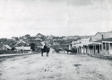
Believed to have been taken sometime between 1858 and 1908, featuring a man with moustache, dressed in hat and long riding coat, seated on a bob-tailed horse, is stopped in the middle of a wide dirt road in Beechworth. He is outside a row of businesses, including R.McKenzie & Sons Grain Store and Mackenzie Family Store (Wholesale & Retail Est. 1855), along a sloping hill. Behind the main rider are a parked horse and laden two-wheeled cart backed up directly outside the grain store's verandah, and another man is driving a horse and four-wheeled wagon forward towards them. At the bottom of the hill is a bridge (Newtown Bridge) with forked road on the far side, leading to a number of houses on both sides of another hill. This image is looking down Bridge Street, Newtown, Beechworth and across to Ford Street (left) and High Street (right). Road-making was a focus of town development during the 1850s, and the wide streets were created on the instructions of the surveyor-general to be between sixty-six and ninety-nine feet wide to give the town a pleasing aspect.This photograph is important in showing the development and expansion of the various businesses and buildings in Bridge Street of Newtown, Beechworth. Black and white rectangular photograph printed on paperReverse: 6980/ PH 118/ 1998.00059/beechworth, new town, newtown, newtown beechworth, local business, mackenzie family store, mackenzie's family store, mackenzie, grain store, bridge, ford steet, high street, colonial australia, australian gold rushes, mining technology, beechworth historic district, indigo gold trail, migration, indigo shire, mckenzie and sons grainstore, mckenzie family store, mckenzie, newtown bridge -
 The Beechworth Burke Museum
Photograph - Photograph - Reproduction, 1890-1900
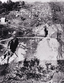
The photograph appears to depict the of the entrance to the Rocky Mountain Tunnel. The Rocky Mountain Tunnel runs from opening of the tunnel, underneath the Beechworth town, to the Gorge. This tunnel drained the excess water from the upper Spring Creek Goldfield to allow for mining access in the area. The Rocky Mountain Co. blasted through the granite rock to create the original 400ft-long tunnel in 1859, but between 1867 and 1871, the Rocky Mountain Gold Sluicing Co. widened and extended it. At its completion, it measured 14ft deep, 6ft wide, and almost half a mile long. The mining surveyor at Beechworth called it 'without doubt, the greatest undertaking of the kind in the colony'. When the company became the Rocky Mountain Extended Gold Sluicing Co. in the mid-1870s, they continued the tunnelling work. The work was reportedly vital to mining being able to continue at Beechworth and may have established world records in tunnelling through hard rock. The entrance at the Gorge side of the tunnel can be seen from the Beechworth Gorge Walk. The tunnel continues to be an outfall drain for the lake and the town.The search for gold is ingrained into the history of Victoria and therefore, images like this one which portray an open cut sluicing site can reveal important information for society and technology for the date when the photograph was taken. This image is of important historical significance for its ability to convey information about sluicing and the methods used to find gold in the late 1800s and early 1900s. It also shows a location where sluicing was undertook which provides insight into the impact of sluicing on the environment at a time when it was done. The Burke Museum is home to a substantial collection of Australian mining photographs which can be used to gain a deeper understanding into life on the gold fields, technology used in mining, the miners themselves and the impact of the gold digging on the environment.A black and white rectangular reproduced photograph printed on matte photographic paper.7814beechworth, beechworth museum, burke museum, australian museum, mining, rocky mountain mining co., rocky mountain mining company, mine, mining company, rocky mountain mine, mine entrance, rocky mountain, gold, gold mining -
 Melton City Libraries
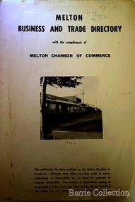
Booklet, Melton Business and Trade Directory, c.1965
BUSINESS TRADE AND DIRECTORY MAP NORTH of High Street RALIEGHS Road - Early settlers Oliver Reierson ( Norwegian) Raliegh SHEBLER Court Auguste EMIL Court Jongebloed Family residence “Hemlich” ALEXANDRA Street Coronation King, Queen Alexandra - 1903 O’NEILS Road Farmer OLDERSHAW Road CORR Grove Early landowner, Teacher at the Common School – Denominational Churches, 1850’s Wesleyan (Methodist) BRYAN Court 1850’s resident renamed from earliest town site - Flat HURLEY Street Early settler and farmers - CHESNEY Road was named Minns, due to duplication altered to Chesney (Minns) SOUTH of High ALKEMADE Drive. Family name ARNOLD Court Family BARRIES Road Charles Ernest Barrie “Darlingsford” 1911 Residence KILPATRICKS Road became Barries Road west of Station Road BLACKWOOD Drive Alexander, Early settler CALLANAN Drive Surveyor early LUBY Court John Luby - Crown Grant Land title KERWIN Street Michael - Crown Grant land title (deleted due to Freeway)Pamphlet of Melton Businesses and map of the townlocal identities, misc., council -
 Melbourne Legacy
Document - Article, Bulletin. Honour for a Past President (Jim Gillespie)
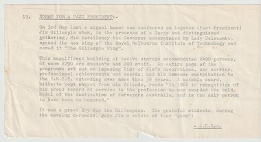
An article from the Melbourne Legacy Bulletin about Legatee Jim Gillespie being honoured by RMIT naming a building after him. Date is not known but likely to be 1969 or 1970. The article mentions 'an honour was conferred on Legatee (Past President) Jim Gillespie when the Governor and Lady Delacombe opens a new wing of the Royal Melbourne Institute of Technology and called it 'The Gillespie Wing". The magnificent building of 12 stories accommodates 2490 persons (2290 students and 200 staff). A page of the programme was set out to list Jim's decorations, war service, and professional achievements and awards and his immense contribution to the RMIT extending over more than 30 years. Also that in 1968 in recognition of his proud record of service to the profession he was awarded the Gold Medal of the Institution of Surveyors Australia, and is the only person to be so honoured at the time. The article was written by JHBA (Legatee Brian Armstrong). The article was part of an album of past presidents from 1965 to 1989. The folder included biographical details and obituaries, eulogies and death notices of prominent Legatees. The items have been catalogued separately.A record of Legatee Jim Gillespie a past president of Legacy and the recognition he received in his career. The information was collected to record the lives of prominent legatees in a folder.Typed partial page from the Legacy Bulletin on Legatee Jim Gillespie - President 1938past presidents, jim gillespie, rmit