Showing 9849 items matching "west"
-
 Eltham District Historical Society Inc
Photograph - Aerial Photograph, Landata, Lower Plenty, Feb. 1956
Centred on present day 217 Old Eltham Road, Lower Plenty bounded by Pitt Street to north, Yarra River to south, Main Road to east and Bonds Road to west. Historic Aerial Imagery Source: Landata.vic.gov.au Aerial Photo Details: Project No :250 Project : MELBOURNE OUTER SUBURBS PROJECT Run : 17 Frame : 116 Date : 02/1956 Film Type : B/W Camera : EAG9 Flying Height : 10000 Scale : 12000 Film Number : 1176 GDA2020 : 37°43'58"S, 145°07'49"E MGA2020 : 335237, 5822186 (55) Melways : 21 E10 (ed. 42)aerial photo, 1956-02, neil webster collection, eltham, main road, bonds road, elham, lower plenty, melway 21e10, pitt street, yarra river -
 Eltham District Historical Society Inc
Photograph - Aerial Photograph, Landata, Eltham, Feb. 1956
Centred on present day Shalbury Avenue, Eltham bounded by Leane Drive and Parsons Road to north, Nyora Road to south, Reynolds Road to east and the Diamond Creek to west Historic Aerial Imagery Source: Landata.vic.gov.au Aerial Photo Details: Project No :250 Project : MELBOURNE OUTER SUBURBS PROJECT Run : 18 Frame : 95 Date : 02/1956 Film Type : B/W Camera : EAG9 Flying Height : 10000 Scale : 12000 Film Number : 1176 GDA2020 : 37°41'57"S, 145°09'51"E MGA2020 : 338145, 5825965 (55) Melways : 22 C1 (ed. 42)aerial photo, 1956-02, neil webster collection, eltham, diamond creek (creek), melway 22c1, nyora road, parsons road, reynolds road, shalbury avenue -
 Eltham District Historical Society Inc
Photograph - Aerial Photograph, Landata, Research, Vic, Feb. 1956
Centred on present day Thompson Crescent, Research bounded by Maroondah Aqueduct to north, Thompson Crescent and Nyora Road to south, Bells Hill Road to east and Eucalyptus Road to west Historic Aerial Imagery Source: Landata.vic.gov.au Aerial Photo Details: Project No :250 Project : MELBOURNE OUTER SUBURBS PROJECT Run : 19 Frame : 6 Date : 02/1956 Film Type : B/W Camera : EAG9 Flying Height : 10000 Scale : 12000 Film Number : 1176 GDA2020 : 37°42'38"S, 145°11'02"E MGA2020 : 339927, 5824736 (55) Melways : 22 H4 (ed. 42)aerial photo, 1956-02, neil webster collection, bells hill road, eltham, eucalyptus road, maroondah aqueduct, melway 22h4, nyora road, research (vic.), thompson crescent -
 Eltham District Historical Society Inc
Photograph - Aerial Photograph, Landata, Research, Vic, Apr. 1963
Centred on present day Thompson Crescent and Nicholson Close, Research bounded by Maroondah Aqueduct to north, Nyora Road to south, Eltham College to east and Eltham Gateway Hotel to west. Historic Aerial Imagery Source: Landata.vic.gov.au Aerial Photo Details: Project No :486 Project : MELBOURNE (1963) PROJECT Run : 5 Frame : 61 Date : 04/1963 Film Type : B/W Camera : RC8 Flying Height : 5100 Scale : 9600 Film Number : 1805 GDA2020 : 37°42'24"S, 145°10'06"E MGA2020 : 338528, 5825143 (55) Melways : 22 D3 (ed. 42)aerial photo, neil webster collection, eltham, 1963-04, eltham college, eltham gateway hotel and conference centre, maroondah aqueduct, melway 22d3, nicholson close, nyora road, research (vic.), thompson crescent -
 Eltham District Historical Society Inc
Photograph - Aerial Photograph, Landata, Eltham, Vic, Apr. 1963
Centred on present day John Street, Eltham between Main and Bible streets bounded by Elsa Court to north, Main Road Bridge to south, Wattle Grove to east and Bolton Street to west. Historic Aerial Imagery Source: Landata.vic.gov.au Aerial Photo Details: Project No :486 Project : MELBOURNE (1963) PROJECT Run : 6 Frame : 123 Date : 04/1963 Film Type : B/W Camera : RC8 Flying Height : 5100 Scale : 9600 Film Number : 1805 GDA2020 : 37°43'12"S, 145°08'54"E MGA2020 : 336800, 5823623 (55) Melways : 21 J6 (ed. 42)aerial photo, neil webster collection, 1963-04, bolton steet, elsa court, eltham, john street, main road, main road bridge, melway 21j6, wattle grove -
 Eltham District Historical Society Inc
Photograph - Aerial Photograph, Landata, Eltham, Vic, Apr. 1963
Centred on present day Eltham Ridge, Bolton Street, Eltham bounded by Elsa Court to north, Main Road to south, Bible Street to east and Reichelt Avenue and Rattray Road to west. Historic Aerial Imagery Source: Landata.vic.gov.au Aerial Photo Details: Project No :486 Project : MELBOURNE (1963) PROJECT Run : 6 Frame : 124 Date : 04/1963 Film Type : B/W Camera : RC8 Flying Height : 5100 Scale : 9600 Film Number : 1805 GDA2020 : 37°43'12"S, 145°08'16"E MGA2020 : 335876, 5823604 (55) Melways : 21 G6 (ed. 42)aerial photo, neil webster collection, 1963-04, bible street, bolton street, eltham, eltham ridge, main road, montmorency, rattray road, reichelt avenue -
 Eltham District Historical Society Inc
Photograph - Aerial Photograph, Landata, Eltham, Vic, Apr. 1963
Centred on present day Griffith Park Road, Eltham bounded by Mount Pleasant Road to north, Yarra River and Templestowe to south, Main Road at Reynolds Road to east and Falkiner Street to west. Historic Aerial Imagery Source: Landata.vic.gov.au Aerial Photo Details: Project No :486 Project : MELBOURNE (1963) PROJECT Run : 7 Frame : 233 Date : 04/1963 Film Type : B/W Camera : RC8 Flying Height : 5100 Scale : 9600 Film Number : 1805 GDA2020 : 37°44'04"S, 145°09'10"E MGA2020 : 337237, 5822053 (55) Melways : 22 A10 (ed. 42)aerial photo, neil webster collection, 1963-04, eltham, falkiner street, griffith park road, melway 22a10, mount pleasant road, reynolds road, templestowe, yarra river -
 Eltham District Historical Society Inc
Photograph - Aerial Photograph, Landata, Eltham, Vic, Apr. 1972
Centred on present day Parsons Road, Eltham bounded by Allendale Road to north, Frank Street to south, Research Shops and Raglan Road to east and Zig Zag Road to west. Historic Aerial Imagery Source: Landata.vic.gov.au Aerial Photo Details: Project No :985 Project : MELBOURNE 1972 Run : 26 Frame : 192 Date : 04/1972 Film Type : B/W Camera : RC10 Flying Height : 5700 Scale : 9600 Film Number : 2636 GDA2020 : 37°42'00"S, 145°09'59"E MGA2020 : 338360, 5825897 (55) Melways : 22 D1 (ed. 42)aerial photo, neil webster collection, 1972-04, allendale road, eltham, zig zag road, frank street, melway 22d1, parsons road, raglan road, research (vic.), research shops, eltham barrel -
 Eltham District Historical Society Inc
Photograph - Aerial Photograph, Landata, Eltham, Vic, Apr. 1972
Centred on present day Woodridge Estate, Eltham bounded by Park Road to north, Mount Pleasant Road to south, Stokes Orchard Estate to east and Eltham Railway Station to west. Historic Aerial Imagery Source: Landata.vic.gov.au Aerial Photo Details: Project No :985 Project : MELBOURNE 1972 Run : 27 Frame : 46 Date : 04/1972 Film Type : B/W Camera : RC10 Flying Height : 5700 Scale : 9600 Film Number : 2636 GDA2020 : 37°42'49"S, 145°09'46"E MGA2020 : 338053, 5824365 (55) Melways : 22 C5 (ed. 42)aerial photo, neil webster collection, 1972-04, eltham, eltham railway station, melway 22c5, mount pleasant road, park road, stokes orchard estate, woodridge estate -
 Eltham District Historical Society Inc
Photograph - Aerial Photograph, Landata, Eltham, Vic, Apr. 1972
Centred on present day Dalton Street at Mount Pleasant Road, Eltham bounded by Arthur Street to north, Yarra River and Kent Hughes Road to south, Eucalyptus Road to east and Susan Street to west. Historic Aerial Imagery Source: Landata.vic.gov.au Aerial Photo Details: Project No :985 Project : MELBOURNE 1972 Run : 28 Frame : 208 Date : 04/1972 Film Type : B/W Camera : RC10 Flying Height : 5700 Scale : 9600 Film Number : 2635 GDA2020 : 37°43'29"S, 145°08'54"E MGA2020 : 336816, 5823118 (55) Melways : 21 J8 (ed. 42)aerial photo, neil webster collection, 1972-04, eltham, arthur street, dalton street, eucalyptus road, kent hughes road, melway 21j8, mount pleasant road, susan street, yarra river -
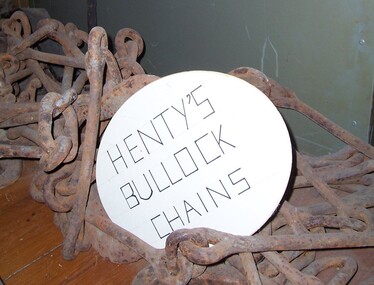 Glenelg Shire Council Cultural Collection
Functional object - Chains - bullock harness, n.d
Thought to be the chains used for the Henty's bullock harness. The Henty family are known as Victoria's earliest European settlers and pastoralists, emigrant squatters who played a defining role in the establishment of Portland and the development of the region's wool trade. Facing challenges as a farmer in early 19th-century England, West Sussex grazier Thomas Henty (1775–1839) turned his sights south to the colonies, where he believed his seven sons would have a brighter future as sheep breeders and wool producers. He had been the first to introduce merino to the south of England, and would do so in the colonies also.Thought to be the chains used for the Henty's bullock harness.Iron chains with fittings for bullock harnesses.farming, rural industry, henty, bullock, chains -
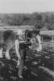 Eltham District Historical Society Inc
Photograph, Guildo Fabbro, Falkiner Street, Eltham with Clydesdale horse
Guildo Fabbro, Falkiner Street, Eltham with Clydesdale horse with harness in field. The site of the Fabbro farm (Diamond Creek side land) is now called Barrack Bushlands. It is doubtful that Fabbro's farm holding was ever called Barrak Park, This title is fairly recent after the Shire of Eltham purchased the land, including the last section in 1993/94. About this time the area on the west side of Falkiner Street was purchased by a private developer and developed as housing. The area in Bell Street opposite the Eltham High School was purchased by the State Government is recent years and is called Fabbro Fields. The Fabbro Family operated their farm in Bell Street, Eltham. 1 black and white photographfabbro's farm, guido fabbro, bell street, clydesdale horse -
 Federation University Historical Collection
Drawing - Artwork - Drawing, Ponsonby Carew-Smyth, 'Design for a Town Hall' by Ponsonby Carew-Smyth, c1895
Ponsonby May Carew Smyth was born at Cork, Ireland, Carew-Smyth studied at the Belfast School of Art and Design. Carew Smyth taught at the national Art Training School, London and Rugby School. He arrived in Australia in January 1891, and was appointed Principal of the Ballarat Fine Art Gallery School (Ballarat West Technical Art School) from 1891 to 1899. In 1907 Carew Smyth was Chief Inspector of Art for the Victorian Education department. He designed commemorative wall plaques for state schools after World War One. In 1936 Carew Smyth was Acting Director of the National Gallery of Victoria.Drawing on card of a principal elevation for the design of a town hall. Includes a "National Art Training School" lable A sticker with the number 2234 A sticker with the words "National Bronze Medal (+ illegble) Stamped 'Work accepted For Certificate" Embossed "Department of Science and Art" with handwritten Certificate 17107ponsonby carew-smyth, architectural drawing, clock tower, ballarat technical art school, ballarat west technical art school, art training school, london, rugby school, ballarat fine art gallery school, art gallery of ballarat, national art training school -
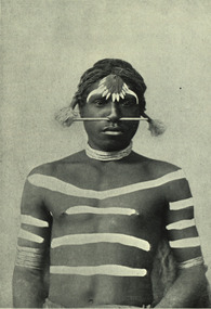 Federation University Historical Collection
Image - black and white, Barwon River Man (New South Wales)
Digitised directly from 'The Native Races of the British Empire: Victoria' The Barwon River in New South Wales is formed through the confluence of the Macintyre River and Weir River (part of the Border Rivers system), north of Mungindi, in the Southern Downs region of Queensland. The Barwon River generally flows south and west, joined by 36 tributaries, including major inflows from the Boomi, Moonie, Gwydir, Mehi, Namoi, Macquarie, Bokhara and Bogan rivers. During major flooding, overflow from the Narran Lakes and the Narran River also flows into the Barwon. The confluence of the Barwon and Culgoa rivers, between Brewarrina and Bourke, marks the start of the Darling River.Black and white Image of an Aboriginal man from Barwon River, New South Wales. Aboriginal people from six language groups originally occupied the area of the Barwon River wetlands. These were the Ngemba, the Baranbinja, the Murrawari, the Ualayai, the Weilwan, and the Kamilaroi peoples. The Aboriginal people generally used the wetlands for hunting, fishing, and gathering uses, and for cultural association.(Wikipedia) The name "barwon" is derived from the Australian Aboriginal words of barwum or bawon, meaning great, wide, awful river of muddy water; and also baawan, a Ngiyambaa name for both the Barwon and Darling rivers. The history, culture and livelihoods of the local Aboriginal people are closely intertwined with the Barwon River and its associated tributaries and downstream flows. (Wikipedia)aborigine, aboriginal, barwon river -
 Victorian Interpretive Projects Inc.
Photograph - Colour, Clare Gervasoni, Sculpture of Portuguese explores at Warrnambool, 02/09/2012
The sculptural installation was a gift from the Portuguese government and presented to Warrnambool City Council. The sculptor, Jose Nuncio, completed the work in 1999, and it was inaugurated at Warrnambool in 2001. Prince Henry the Navigator founded a school of navigation in Sagres, Portugal. This led to navigation techniques that made the 15th century voyages of discovery possible. The vision of Prince Henry brought together ship builders, cartographers, instrument makers and mathematicians. Vasco de Gama rounded the southern tip of Africa and sailed across the Indian Ocean to India in 1496. This started a new era of trade and exploration, expanding the boundaries of the known world, and linking the east with west.Six colour photographs of a sculptural installation at Warrnambool. Busts of Vasco De Gama and Prince Henry the Navigator feature in the installation. Images also include two informative plaques containing information on De Gama and the Prince.warrnambool, exploration, navigator, de gama, prince henry the navigator, portugal, portuguese, david atkinson, john pandazopoulos -
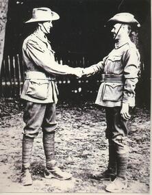 Lake Bolac & District Historical Society
Black and white photograph, Pte Donald Murray meeting Pte Ray Hargreaves in London during WW1
Private Donald Hector Murray greeting Private Edward Raymond Hargreaves in London during WW1. Donald enlisted 17/04/1916 in the 37th Infantry Battalion and embarked for Europe 03/06/1916. He died of Tubercular Pleurisy on 21/12/1916 at the Military Hospital, Fargo England, whilst on active service. He is buried in the Durrington Cemetery there. Edward enlisted in the 5th Infantry Battalion on 08/07/1915 and embarked for France 11/10/1915. Upon his return he was granted a Soldier Settler's block west of Lake Bolac in 1921. He married Flora Graham in 1925. murray, 37th infantry battalion, hargreaves, graham, 5th infantry battalion, london, ww1, fargo military hospital, durrington cemetery, lake bolac -
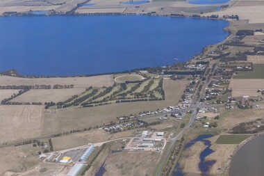 Lake Bolac & District Historical Society
Colour photograph, Aerial view of Lake Bolac and village. After the rain, 2010
Aerial view of Lake Bolac after the drought had broken in late 2010. The fresh-water lake is now full, as are the wetlands. Note the edge of the salt-lake in the bottom right, the Industrial Estate bottom left and centre, the golf course, the current footy oval, Bowling Club, tennis courts and swimming pool with the P-12 College through the trees on the bank of the lake. An Archaeologist might be able to discern the original footy oval bottom centre, built on what was once the town Common (below the industrial buildings),and the second oval (above the salt lake.) The houses are spreading along the west bank of the lake beyond the school.lake bolac, 2010, village, fresh-water lake, salt lake, golf, tennis, bowling, swimming, college, -
 Ballarat Tramway Museum
Postcard, Valentine & Sons Publishing Co, "Lydiard Street showing George Hotel Ballarat", 1931
Valentine Series postcard of the early 1930s of No. 27 inbound in Lydiard St Nth. Valentine series No. 1492, with the caption "Lydiard Street showing George Hotel, Ballarat". See page 59 of The Golden City and its Tramways and for the photo itself. Photo shows the wooden centre poles, street lighting, tram 27 in ESCo colour scheme, and buildings on the west side of Lydiard St North, including the George Hotel, A.M. Palmer & Co Chemist, Wm Hiscock Dentist and other buildings. A horse-drawn cart and two motor cars parked at the kerb. See 3893 for a digital image and reproduction photograph.Yields information about Lydiard St Nth in the 1930's, the centre poles, traffic and the appearance of the trams.Postcard black and white, divided back. Card No. 1492Has on the rear in pencil "KT" and "to be copied" tramways, trams, tram 27, lydiard st nth, george hotel, centre poles -
 Ballarat Tramway Museum
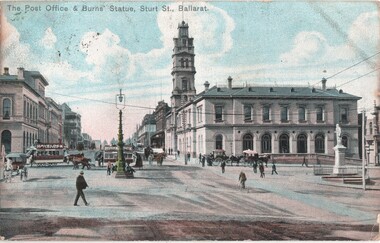
Postcard, The Post Office & Burns Statue Sturt St Ballarat, c1905
Image of the intersection of Sturt and Lydiard Streets looking north towards Lydiard St. Photograph shows a horse drawn tram turning from Sturt into Lydiard St North, while another crosses Lydiard St, heading west along the north side of the street. Photo shows the Post Office, the Robert Burns statue, and the large arc lamp in the middle of the intersection. Two copies held. On the rear of the first copy is a Birthday and New Year message to Mrs Serpell of the Wesleyan Parsonage in Timaru New Zealand and the second has been posted to a person in Antwerp Belgium - dated 19 Feb. 1909.Yields information about the intersection of Sturt and Lydiard Streets in the horse tram era and the operation of the horse tram system.Postcard - coloured - divided back, post marked Ballarat 21?-12-1905 with a Victorian 1d penny stamp and over stamped with a "5". 2nd copy has had the stamp removed.See Contextsturt street, horse trams, post office, ballarat, tramways, lydiard st, burns statue -
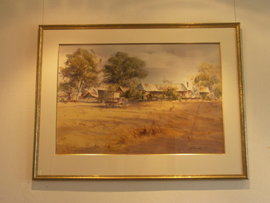 Friends of Westgarthtown
Painting, John Borrack, Last Days Ziebells "The Pines" Thomastown
Painted from the home (or front) paddock which ran south to the creek. The paddock was used for the cultivation of lucerne and maize crops in the lower regions while closer to the house where Ainwick Crescent is now situated, it was a burgeoning market garden for the cultivation of all varieties of vegetables. The large pines beyond, sheltered the farmyard on the west of Gardenia Road. That complex can be partly glimpsed on the left of the painting. This is a directly painted watercolour relying on the use of white paper and transparencies to impart a feeling of morning light. The figure is the artist's mother for whom the picture was painted. Provenance: Augusta Borrack (nee Ziebell) Collection, John Borrack CollectionWatercolour painting, depicting Ziebell's Farmhouse from the south (Thomastown and Mernda). Painting is mounted in a gold frame with cream board.Artist signature: John Borrack; Last Days at Ziebells "The Pines" Thomastown, 'Pro mea matre hanc picturan feci (In Memoria)'illustrations, watercolours, john borrack, ziebell, watercolour, painting -
 Port Fairy Historical Society Museum and Archives
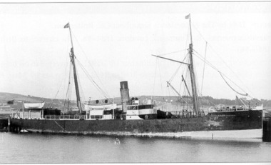
Photograph
Coastal Steamer which occasionally visited Port Fairy DINGADEE 640 gross tons. Lbd: 180'4" x 28'1" x 13'6". Built by Queenstown & Passage West Dock Co., Queenstown Ireland. Acquired 1883 ASN Co. Of AUSN Co 1887 and sold 1890 to Union Steamship Co., New Zealand. October 1900 owned by Black Ball Coal Co. 1903 owned by Dingadee Steamship Co. 1906 owned by T Tanaka of Tokyo and renamed Chokyu Maru No 3. 1924 owned by Taiwan Setofuku. Hayashi Kozo owned from January 1924 until scrapped 1926Black and white photograph of Ship with derrick and masts ship, boat, sea, river, ss dingadee -
 Melbourne Legacy
Document, Story Behind the Stamps, 2006
An article written by Legatee Bill Rogers about volunteers, led by Beryl Billing, who process used stamps for sale to fundraise for Legacy. The article may have appeared in the Bulletin. It acknowledged the huge amount of work Beryl had done over the years. Beryl's husband was a Legatee with Dandenong/West Gippsland Group (now called South Eastern). Beryl started the stamp group in February 1981 and over 27 years the stamp group raised $208,698. Document was from a folder of documents donated to the archive by Legatee Bill Rogers that related to his time as President (March 2006 - March 2008) or as a legatee.A record of the acknowledgement given to long-standing volunteers.One A4 page by Bill Rogers about Beryl Billing and the Stamp ladies.beryl billing, stamps -
 Wodonga & District Historical Society Inc
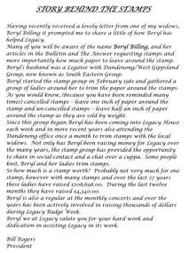
Negative - Haeusler Glass Negatives Collection - Louis Haeusler's house in Wodonga West
The Wodonga Historical Society Haeusler Collection provides invaluable insight into life in late nineteenth and early twentieth century north east Victoria. The collection comprises manuscripts, personal artefacts used by the Haeusler family on their farm in Wodonga, and a set of glass negatives which offer a unique visual snapshot of the domestic and social lives of the Haeusler family and local Wodonga community. This digital image was produced from one of the glass negatives that form part of the collection, probably taken by Louis Haeusler (b.1887) with the photographic equipment in the Wodonga Historical Society Haeusler Collection. This house was owned and built by Louis Haeusler in Wodonga West,This item is unique and has well documented provenance and a known owner. It forms part of a significant and representative historical collection which reflects the local history of Wodonga. It contributes to our understanding of domestic and family life in early twentieth century Wodonga, as well as providing interpretative capacity for themes including local history and social history.Digital image created from the Haeusler Glass negative collection. A small wooden house built in a cleared area. This house was built and owned by Louis Haeusler C. 1910wodonga pioneers, haeusler family, glass negatives, dry plate photography, louis haeusler, pioneer housing -
 Wodonga & District Historical Society Inc
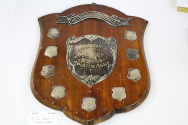
Functional object - Thomas Chubb Shield, C. 1936
The Baranduda and District School Sports Association held its first interschool sporting competition in 1936. Schools included in this association were Allan’s Flat, Bonegilla, Baranduda, Leneva, Mitta Junction, Staghorn Flat and Wodonga West. This commemorative trophy, The Thomas Chubb Shield, was donated to the Sports Association by Mr. Albert John Chubb, in memory of his father. Mr. Thomas Chubb was a successful businessman in Albury and an active supporter of many institutions and community organisations in the Albury Wodonga area. Mr. Albert Chubb actively supported school sports carnivals across the district, including being the official starter at many events.This trophy has local social and cultural significance as it provides evidence of sporting and social interaction between the small schools in the Wodonga and surrounding communities,A wooden shield presented to recognise winners of the Baranduda and District School Sports Association from 1936 to 1949. A metal hanger is attached to the top.On top metal banner "THE THOMAS CHUBB SHIELD" . On central shield "BARANDUDA /AND/DISTRICT/ SCHOOLS/ SPORTS ASSN. On small shields from top to bottom, "LENEVA 1936/ BONEGILLA 1939/ LENEVA 1941/ LENEVA 1949/ LENEVA 1948/ LENEVA 1947/ ALLANS FLAT 1940/ MITTA JUNCTION 1937"baranduda sports association, school sports, wodonga district, thomas chubb -
 Melbourne Legacy
Article, Bulletin VALE Legatee William (Bill) Alfred Braidie
An article from the Melbourne Legacy Bulletin on the death of Legatee Bill Braidie (President of Melbourne Legacy in 1974). The Bulletin published articles on Legatees when they passed away. Legatee Bill Braidie died in 1979 aged 54 years. During his war service he served in the RAAF in the South West Pacific area. He joined Legacy in 1964 after being nominated by Legatee Terry Kirby and Legatee Ray Mitchell. The article was part of an album of past presidents from 1965 to 1989. The folder included biographical details and obituaries, eulogies and death notices of prominent Legatees. The items have been catalogued separately.A record of Legatee Bill Braidie a past president of Legacy. The information was collected to record the lives of prominent legatees in a folder.Typed copy of a page from the Legacy Bulletin on the death of Legatee Bill Braidie - President 1974Bulletin No 2451. 3.4.1979. Page No 1 and 2past presidents, vale, bill braidie -
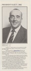 Melbourne Legacy
Document - Article, Legatee E J (Ted) Larkin, President 1982
A cutting from from a Melbourne Legacy President's report showing a photo of Legatee Ted Larkin (President of Melbourne Legacy in 1982). It was collected to be a record of a photo of past presidents. Legatee Ted Larkin served as a Warrant Officer wireless Air Gunner with Number 2 Squadron RAAF in the South West Pacific during World War 2. He was inducted into Melbourne Legacy in 1961 on the nomination of Legatee Fred Holdsworth. The article was part of an album of past presidents from 1965 to 1989. The folder included biographical details and obituaries, eulogies and death notices of prominent Legatees. The items have been catalogued separately.A record of Legatee Ted Larkin a past president of Legacy. The information was collected to record the lives of prominent legatees in a folder.An article with a black and white photo of Legatee E J (Ted) Larkin - President 1982.past presidents, ted larkin -
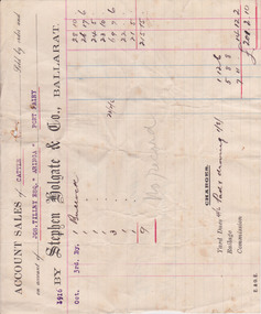 Warrnambool and District Historical Society Inc.
Document - Docket, Wilson & Anderson Jos Tilley 1916, 1916
This docket from the firm of Stephen Holgate and Co. of Ballarat gives details of this firm’s sale in 1916 of nine bullocks on behalf of Joseph Tilley of ‘Aringa’ of Port Fairy. The sale yielded £215-15-0 and, with costs of £14-12-2, the profit for Joseph Tilley was £201-2-10. Stephen Holgate established his auctioneering firm in Ballarat in the late 19th century and was an authority on sheep and cattle breeding. Joseph Tilley was farming at ‘Aringa’ in the early 20th century and also owned the Penshurst Hotel. ‘Aringa’, five miles west of Port Fairy on the Portland Road, was established by John Ritchie in 1839.This docket is of some importance as it is an original one and gives details of a 1916 sale of cattle with the names Joseph Tilley and Stephen Holgate of interest. It gives us the prices for bullocks in 1916 and the type of receipt forms used at that time.This is an original receipt for an account sale of 1916. The docket is a printed one from the firm of Stephen Holgate and Co. of Ballarat with printed blue and red lines for entering the details of the sale. The client’ s name is typed in blue type and the details of the sale are handwritten. On the back of the docket: ‘Wm Delaney from Lin Shoppee’ ‘1916’aringa, joseph tilley, stephen holgate and co. -
 Warrnambool and District Historical Society Inc.
Administrative record (Collection) - Warrnambool Hospital Records, Warrnambool Hospital Records
Records handed to the Warrnambool & District Historical Society by Warrnambool Hospital AuthoritiesEnsuring maintenance and preservation of Warrnambool Hospital recordsLedgers and other material kept in A3 Archival boxes and housed on shelves in the W.D.H.S. Archives RoomLedgers and other Historical records of the Warrnambool Hospital including Letter Books, Annual Reports, Cash Books, Admissions, Donors' Registers, Receipts and Expenditure Registers and Committee Minute Bookswarrnambool hospital and benevolent asylum, warrnambool base hospital, south west health carewarrnambool hospital and benevolent asylum, warrnambool base hospital, south west health care -
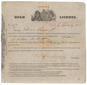 Old Colonists' Association of Ballarat Inc.
Document - Gold License, Gold License issued to Edwin Smart, 28/01/1853
The Old Colonists Association Minute Book records: 'James Smart presented the Association with a Gold Diggers License dated 28th January 1853, it being resolved a vote of thanks be recorded.' The headwaters of the Loddon River rise on the northern slopes of the Great Dividing Range east of Daylesford. The river rises below Musk near Trentham and Lyonville from where it heads northward to Glenlyon and on to Loddon Falls. It then flows generally northward through Guildford and Newstead, 40 kilometres (25 mi) west of Bendigo, then towards the Murray River. The Upper Loddon Plains is within the traditional lands of the Dja Dja Wurrung people.Gold License issued to Edwin Smart on 28 January 1853 at the Upper Loddon.gold license, edwin smart, gold mining, james smart, upper loddon -
Vision Australia
Audio - Sound recording, Sunday Special: RVIB history book launch, 2005
On Wednesday 23rd February 2005, after a two year project of research and interviews with pupils, workers and staff, 'The Lighthouse on the Boulevard' (a history of the RVIB) was launched. In this edition of Sunday Special, MC Michael Walsh introduces Vision Australia CEO Gerard Menses, author Dr Judith Buckrich, participants Reuben Ryan, Steven Herd, David Blyth and Deputy Mayor of Melbourne Gary Singer who spoke at the launch. Afterwards Marjorie West speaks with Esme Dunnell, Graeme and Carol McGowan, Trudi Westh, Ray Whiting, Dorothy Hamilton, Robyn Stevens and Ted Peterson, who also contributed to the book.Sunday Special radio program on the launch of 'Lighthouse on the Boulevard'royal victorian institute for the blind, roberta ashby, michael walsh, gerard menses, judith buckrich, reuben ryan, steven herd, david blyth, gary singer, marjorie west, esme dunnell, graeme mcgowan, carol mcgowan, trudi westh, ray whiting, dorothy hamilton, robyn stevens, ted peterson