Showing 6950 items
matching squares
-
 Eltham District Historical Society Inc
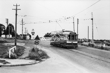
Photograph, Bendigo Tramways No. 7 departs from Thunder Street in North Bendigo en route to Golden Square, Bendigo, January 1972, Jan 1972
The tram line proceeds up to the left just pass Moray Crescent where it terminated alongside the railway line in North Bendigo in 1972Digital TIFF file Scan of 35mm Ilford FP3 black and white negative transparencybendigo, bendigo tramways no. 7, george coop collection, moray crescent, north bendigo, railway crossing, railway line, thunder street, tram -
 Eltham District Historical Society Inc
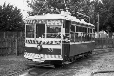
Photograph, Golden Square route Bendigo Tramways No. 28 parked, possibly near the Arnold Street Tram Depot, Bendigo, January 1972, Jan 1972
Birney (USA manufacture) tram carDigital TIFF file Scan of 35mm Ilford FP3 black and white negative transparencyarnold street depot, bendigo, bendigo tramways no. 28, eaglehawk, george coop collection, golden square, tram, birney (usa) tram car -
 Bendigo Military Museum
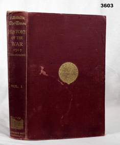
Book - BOOK, WW1, The Times - History of the War 1914, 1914
Vol I . Hard cardboard cover, red buckram, gold print on front & spine. Gold print round seal on front. 516 cut, plain, white, slightly glossy pages. Black / white photos & maps. Bookshop sticker on front end paper, title page: “D Hope, Bookseller, Devonport, Tas” Handwritten in black ink on front end paper: “Henry J Curwen Devonport Feb 27 1915” Handwritten in blue ink on title page: “Mary P Clancy”book, the times, 1914 -
 Federation University Historical Collection
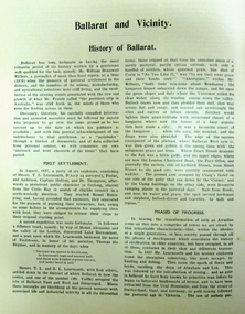
Document, Cyclopedia of Victoria: Ballarat , 1904, 1904
Digital images of the Ballarat section of the Cyclopedia of Victoria, 1904cyclopedia of victoria, ballarat, ballarat benevolent asylum, john adam, gold discovery, lake wendouree, boat house, sailing, eureka stockade, ballarat botanical gardens, statuary, statues, ballarat school of mines, ballarat town hall, sturt street, shoppee square ballarat, ballarat mecahanics' institute, ballarat hospital, henry cuthbert, charles collett shoppee, john murray, richard greenwood middleton, john m. kline, john ritchie, thomas stoddart, william little, john robson, hugh v. mckay, h.v. mckay, n. clark, a. h. powell, r.j. powell, edward shaw, charles j. reid, frederick g. haymes, james thomas mitchell, robert scott, frane longden, robert d. pinnock, thomas a. wilson, sydney b. fisher, david bartholomew, t.r. treloar, s-ray, w. cornell, alexander greenfield, andrew callow, victorian mounted rifles, s.g. valentine, andrew scott, thomas robertson, john gordon robertspm, w.t. rowe, thomas a. oddie, william morris, jospeh walshe, william acheson, joseph dill, william mason, llanberis no 1, anthony jenkin, james carey, wlliam emery, percy kent, henry bath, j. rowe, john couttie, william sansom, francis coote, john mckenna, robert ditchburn, thomas mitchell, john daniel, george williams, william treloar, r.b. squire, jonah ward, robert smyth, william bell, thomas couper, w. joseph, william wallace, benjamin dowling, robert crawford, alexander aikens, c. dennison, w.f. coltman, federal timber yard, george hotel, williaim dones, j. dreaden, richard's and co, j.a. gear, r.w. fleming, l.e. cutter, l.s. cutter, a.e. cutter, c.f. cutter, george anderson, w.e. longhurst, christopher howlett, david mcgrath, james wishart, f.g. reeve, eureka iron works, j.e. cowley, albert foundry, john robert harrison, j.b. cameron, p.b. sutherland, george richards, ballarat brass foundry, m.b. john, morgan john, m.w.b. john, james smith, w.p. davies, j.t. vercoe, james kelly, williaim osbourne, alexander mcdonald, alexander e. mcdonald, henry john symons, bridge street flood -
 Federation University Historical Collection
Photograph - Digital images, Elise Whetter, Digital photographs of "One" ticket and square format packaging, 2023
Photograph of invitation to third year Graphic Design / Multimedia dinner and portfolio show. The dinner was held at the Ballarat Fine Art Gallery, and show at the university Camp Street Campus. For this student show, Melbourne-based designers were brought to Ballarat via special carriage on a V/Line train to Lydiard Street Station and walked to the new Camp Street Campus.Digital photographs of optical disc (DVD rom) in clear plastic case created by University of Ballarat, Bachelor of Visual Arts (Graphic Design / Multimedia) third year, graduating students, 2002.university of ballarat, federation university, graphic design, multimedia, camp street campus, new north, arts academy -
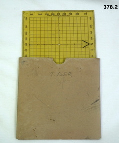 Bendigo Military Museum
Equipment - PROTRACTOR, SQUARE, C.1939 -45
Belonged to Thomas Henry ISER No V24933 and VX102660 2nd AIF. Refer Cat No 383.2 for his service history..1) 360 deg Protractor labelled as "Direction finder" Used for map navigation planning,yellow plastic. .2) Cardboard sleeve for .1).marked "T. ISER"navigation, protractor, military, equipment -
 Mission to Seafarers Victoria
Drawing - Artist sketch, Gerry Cummins & Jill Stehn Pty. Ltd, 1980
The window in this photograph was commissioned by the Sandringham Yacht Club in conjunction with a Masonic Lodge and work carried out by Gerry Cummins in 1980. In the background is the S.S. 'Kanimbla' built 1935, Belfast for McIlwraith McEacham and was the last large passenger ship built specifically for Australian owners. Designed to carry 400 passengers , she plied her trade around the Southern and Eastern Ports of Australia. In WW2 she was an armed merchant cruiser and served in Indian waters and escorted the 1st convoy out of the Singapore after the Japanese invasion. She later operated in the Pacific after the war and after repatriation duties she was decommissioned and subsequently sold to be renamed 'Oriental Queen' which eventually caught fire and sank. . The small yacht in the foreground refers to the Sandringham YC. Window measurements: 600mm x 900mmShows the link with Freemasonry.Sketch in pencil and ink on cream paper for an arched stained glass window depicting a yacht.Bottom left corner: Proposed Stained Glass Window, Mission to Seamen. (Scale: Full Size) Right Left corner: Gerry Cummingsfreemasons, st peter chapel, flinders street, mission to seafarers, gerry cummins, jill stehn, stained glass window, sandringham yacht club, hearts of oak lodge, yacht, symbols, square, compass, ss kanimbla -
 Greensborough Historical Society
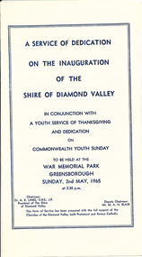
Program, Greensborough Press Pty Ltd, A Service of dedication on the inauguration of the Shire of Diamond Valley, 2nd May 1965, 02/05/1965
A record of the service of dedication of the Shire of Diamond Valley held on 2/5/1965, in conjunction with a youth service of thanksgiving and dedication on Commonwealth Youth Sunday. Held at War Memorial Park Greensborough.The Shire of Diamond Valley was a Local Government Area located about 20 kilometres northeast of Melbourne. The shire covered an area of 74.38 square kilometres and existed from 1964 until 1994. This Program celebrates the inauguration of the new Shire.Single fold page, white with blue text. Includes music and words for 3 hymns.shire of diamond valley, greensborough, aka lines, commonwealth youth sunday 1965 -
 Greensborough Historical Society
Photograph, Shire of Diamond Valley, Engineering Team 1992, 1992_12
Records the Engineering staff of the Shire of Diamond Valley in 1992.The Shire of Diamond Valley existed briefly from 1964 until the rationalisation of councils in the 1990's. The Shire of Diamond Valley was a Local Government Area located about 20 kilometres northeast of Melbourne. The shire covered an area of 74.38 square kilometres and existed from 30/09/1964 until 14/12/1994.A framed colour photograph of a group of people with the appropriate names below.Nilshire of diamond valley, council officers -
Glenelg Shire Council Cultural Collection
Book, Louis Boussenard - author, The Crusoes of Guyana, c. 1884
Children's book, hard cover, olive green; title and author's name in gold; alternative title and illustrations in black. Back cover has publisher's monogram impressed into it. Spine gold and black print, black illustrationFront: Inside front cover: 'Robert Arthur Henty with love and best wishes from Aunt Edie' handwritten in inkchildrens literature, book -
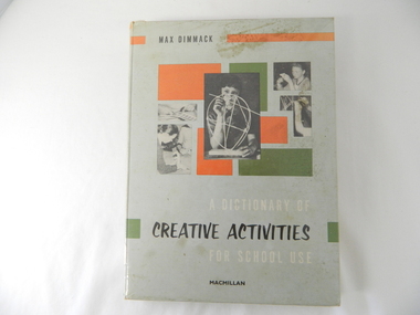 Kiewa Valley Historical Society
Book - Reference Teaching, Circa 1963
This teacher's aid publication targets the creative and imaginative areas of primary school children's development. It is in a time period at the beginning of television(home intrusion) broadcasts and concentrates on the mental and physical tasks that produce tangible(physical) outcomes. The book concentrates on furthering the students abstract regions of their imagination. This was in a period where physical not electronic flexibility were the target of development. The increase in visual communications both at home and outside the home through social media means has intruded into the fundamentals that is presented in this teacher's aid publication.This publication is significant to both the Alpine and the Kiewa Valley regions because it demonstrates the Victorian State's Educational objectives of this period in time (1960's - 70's). The primary school's educational objectives were to enhance the development of school children's abstract mental abilities. These abilities prompted the mental processes to "think outside of the square" and is one of the major factors behind the development of "new inventions". This ability has produced many "Australian" inventions that have had worldwide applications. This book has a hard cover with photographs of "school" children constructing various "simple" items.Inside cover has a sticker "HALL'S BOOK STORE" and underneath in smaller print "New, Used and Rare Books" underneath this "371 Bourke Street, Melbourne' underneath "262 Chapel Street, Prahran". On the fly leaf is stamped "STATE SCHOOL 4590 BOGONG Vic" and written below "1769" 680 DIM"book, school, mental and physical stimulation, school activities -
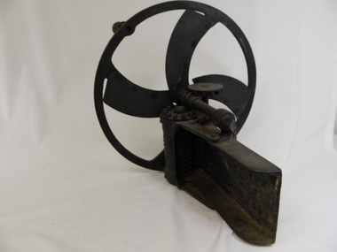 Kiewa Valley Historical Society
Cutter Green Feed, Hocking, estimated 1935; Early 20th Century
This iron chaff cutter was a vital piece of rural machinery especial for cattle in areas subjected to limited grass growing seasons. The Kiewa Valley and Alpine regions were up to the 21st century "snowed" in. The conditions requiring summer crops and fodder to be prolonged for the harsh winter climate are now becoming less and less and may confirm the precursor of "global warming". The Kiewa Valley is still a strong base for dairy cattle and other stock requiring all year access to hay/grass supplies. The use of, now defunct, Tobacco drying sheds for the storage of hay and other fodder is typical of the Australian farmer/grazier's adaptability to utilise anything available. To think outside the square.Black Iron Chaff Cutter. The wheel has a single piece inside with 4 curved spokes with adjustable blades attached by 4 screws & 3 rivets. The wheel has a wooden handle. Operated by cogs. HOCKING GREASE BALLARAT COGS FREELYagriculture, farm machinery, stock feeding, grazier, farm animals -
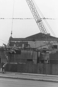 Ringwood and District Historical Society
Photograph, Demolition to make way for Target Square shopping complex, Seymour Street, Ringwood - 1984
Written on back of photograph, "Demolition to make way for Target and market 1984". -
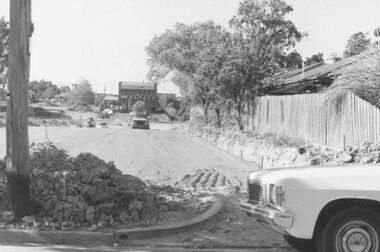 Ringwood and District Historical Society
Photograph, Road construction works for Target Square Shopping Centre, viewed towards Charter and Seymour Streets from Bond Street, Ringwood - 1984
Written on back of photograph, "New roadway leading to Target". -
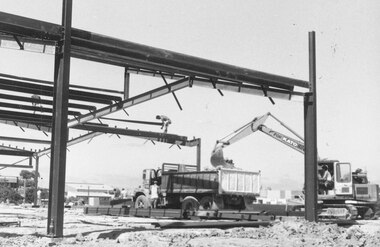 Ringwood and District Historical Society
Photograph, Work on the "New Ringwood Market" buildings, Target Square, Ringwood. 1982
Written on back of photographs: SS0346r: "E654. N23A. Work on the market buildings". and SS0346n :"E654. N24A. 18/1/82. Work on the market buildings" -
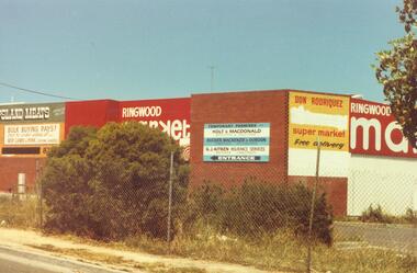 Ringwood and District Historical Society
Photograph, Seymour St. Ringwood, 1982. Ringwood Market / Target Square (3 views)
Catalogue card reads, "Seymour St. Ringwood, 1982. ... Ringwood Market." 3 Views. -
 Orbost & District Historical Society
black and white photograph, mid 20th century
Those identified in this photograph are: Grace Cameron - back row second right and Effie Wait on the left. (Smooker? Firth?)This photograph is a pictorial record of typical women's fashion in the mid 20th century when women's dresses were were modest, revealing very little skin, compared to today’s fashion. Squared shoulders, narrow hips, and skirts that ended just below the knee were the height of fashion. Tailored suits were also quite popular. Generally older women wore hats, gloves and jewellery. The women in the photograph are associated with Orbost.A black / white photograph of a group of women most wearing hats and jewelry. on back- "left Effie Wait Grace Cameron back second row right"cameron-grace wait-effie orbost-social-gathering -mid 20th -
 Marysville & District Historical Society
Booklet - Information booklet, Ann Thomas, Wilks Creek Bridge, 1993
A history of the Wilks Creek Bridge and its connection to the Yarra Track.Paperback. Front cover has an old photograph of the Wilks Creek Bridge.non-fictionA history of the Wilks Creek Bridge and its connection to the Yarra Track.wilks creek bridge, yarra track, narbethong, marysville, victoria, clement wilks, wood's point goldfields, jordan goldfields, john monash, monash and anderson, 2009 black saturday bushfires -
 Marysville & District Historical Society
Photograph (Item) - Colour photograph, Pre 2009
A colour photograph of the Wilks Creek Bridge near Marysville in Victoria.A colour photograph of the Wilks Creek Bridge near Marysville in Victoria. The Wilks Creek Bridge is a former timber and bluestone road bridge on the Yarra Track, and is located just off the Black Spur route, between Narbethong and Marysville, Victoria, Australia. It was built in 1870 to the design of colonial Public Works Department engineer Clement Wilks as part of the construction of a new road to the Woods Point and Jordan Goldfields. Like many bridges of the period, it had a timber superstructure employing squared beams supported by struts and straining pieces, on cut bluestone abutments. The bridge was remodelled around 1900 by engineer John Monash of the famous bridge-engineering firm of Monash and Anderson. It was last used for heavy vehicular traffic in 1980 following the realignment of Marysville Road, and was left to decay until its demolishment in 2008. All timber traces of the bridge were destroyed in the 2009 Black Saturday fires. The handcrafted bluestone masonry wingwalls and abutments, especially shaped to receive timber struts, rate among the earliest of its kind surviving intact in Victoria.wilks creek bridge, yarra track, narbethong, marysville, victoria, clement wilks, wood's point goldfields, jordan goldfields, john monash, monash and anderson, 2009 black saturday bushfires -
 Marysville & District Historical Society
Photograph (Item) - Black and white photograph, 1993
A black and white photograph taken at the re-opening of the Wilks Creek Bridge picnic area and launch of Ann Thomas' book Wilks Creek Bridge.A black and white photograph taken at the re-opening of the Wilks Creek Bridge picnic area and launch of Ann Thomas' book Wilks Creek Bridge. The Wilks Creek Bridge is a former timber and bluestone road bridge on the Yarra Track, and is located just off the Black Spur route, between Narbethong and Marysville, Victoria, Australia. It was built in 1870 to the design of colonial Public Works Department engineer Clement Wilks as part of the construction of a new road to the Woods Point and Jordan Goldfields. Like many bridges of the period, it had a timber superstructure employing squared beams supported by struts and straining pieces, on cut bluestone abutments. The bridge was remodelled around 1900 by engineer John Monash of the famous bridge-engineering firm of Monash and Anderson. It was last used for heavy vehicular traffic in 1980 following the realignment of Marysville Road, and was left to decay until its demolishment in 2008. All timber traces of the bridge were destroyed in the 2009 Black Saturday fires. The handcrafted bluestone masonry wingwalls and abutments, especially shaped to receive timber struts, rate among the earliest of its kind surviving intact in Victoria.wilks creek bridge, yarra track, narbethong, marysville, victoria, clement wilks, wood's point goldfields, jordan goldfields, john monash, monash and anderson, 2009 black saturday bushfires -
Marysville & District Historical Society
Document (Item) - Heritage Report, Biosis Research Pty Ltd, Heritage Report-Dismantling of Wilks Creek Brdige Deck Marysville, Unknown
A heritage report on the dismantiling of the Wilks Creek Bridge deck in Marysville in Victoria.A heritage report on the dismantiling of the Wilks Creek Bridge deck in Marysville in Victoria. The Wilks Creek Bridge is a former timber and bluestone road bridge on the Yarra Track, and is located just off the Black Spur route, between Narbethong and Marysville, Victoria, Australia. It was built in 1870 to the design of colonial Public Works Department engineer Clement Wilks as part of the construction of a new road to the Woods Point and Jordan Goldfields. Like many bridges of the period, it had a timber superstructure employing squared beams supported by struts and straining pieces, on cut bluestone abutments. The bridge was remodelled around 1900 by engineer John Monash of the famous bridge-engineering firm of Monash and Anderson. It was last used for heavy vehicular traffic in 1980 following the realignment of Marysville Road, and was left to decay until its demolishment in 2008. All timber traces of the bridge were destroyed in the 2009 Black Saturday fires. The handcrafted bluestone masonry wingwalls and abutments, especially shaped to receive timber struts, rate among the earliest of its kind surviving intact in Victoria.wilks creek bridge, yarra track, narbethong, marysville, victoria, clement wilks, wood's point goldfields, jordan goldfields, john monash, monash and anderson, 2009 black saturday bushfires -
 Glen Eira Historical Society
Album - Album page, Tudor Court, Kooyong Road, Dec 1972
This photograph is part of the Caulfield Historical Album 1972. This album was created in approximately 1972 as part of a project by the Caulfield Historical Society to assist in identifying buildings worthy of preservation. The album is related to a Survey the Caulfield Historical Society developed in collaboration with the National Trust of Australia (Victoria) and Caulfield City Council to identify historic buildings within the City of Caulfield that warranted the protection of a National Trust Classification. Principal photographer thought to be Trevor Hart, member of Caulfield Historical Society. Most photographs were taken between 1966-1972 with a small number of photographs being older and from unknown sources. All photographs are black and white except where stated, with 386 photographs over 198 pages. Sands & McDougalls directory of Victoria : 1970 gives address as 141 Kooyong Road, Caulfield North. "Caulfield's Building Heritage" p67 includes that this mansion was originally called Fairhaven, built for George Hope, a dairy farmer. He changed the name to Tudor Court in 1915 when he moved his dairy to Cranbourne.Page 116 of Photograph Album with three photographs (one portrait and two landscape) of different views of Tudor Court in its garden. Handwritten: "Tudor Court" Kooyong Road [top right] / Neg 252 Dec 1972 [under top left photo] / Neg 251 Dec 1972 [under top right photo] / Neg 253 Dec 1972 [under bottom left photo] / 116 [bottom right]trevor hart, caulfield north, kooyong road, mansion, verandah, tudor court, george hope, terracotta tiles, terracotta roof, arched windows, port cochere, square bay window, timber balustrade, columned balcony, receptions, fairhaven, arcare caulfield aged care, 1910's, spire, ridge capping, conical roof, verandahs, victorian architectural style, tudor style, queen anne style, lead lights windows, shingle roofs -
 Glen Eira Historical Society
Album - Album page, Crotonhurst, Hawthorn Road, Circa 1972
This photograph is part of the Caulfield Historical Album 1972. This album was created in approximately 1972 as part of a project by the Caulfield Historical Society to assist in identifying buildings worthy of preservation. The album is related to a Survey the Caulfield Historical Society developed in collaboration with the National Trust of Australia (Victoria) and Caulfield City Council to identify historic buildings within the City of Caulfield that warranted the protection of a National Trust Classification. Principal photographer thought to be Trevor Hart, member of Caulfield Historical Society. Most photographs were taken between 1966-1972 with a small number of photographs being older and from unknown sources. All photographs are black and white except where stated, with 386 photographs over 198 pages. Dr Geulah Solomon's 4 volume book "Caulfield's Heritage" Vol 1 p 35 "...an elaborate double-storey spreading mansion which brought together several architectural styles to create a fairytale castle effect...". Dr Solomon indicates that the mansion was demolished circa 1937.Page 76 of Photograph Album with two portrait photographs of Crotonhurst and its grounds.Handwritten: "Crotonhust " (dem) Hawthorn Road [top right hand corner] / 76 [bottom right]trevor hart, caulfield, architectural features, architectural styles, hawthorn road, crotonhurst, north caulfield, gothic, george henry frederick webb, george webb, 1860's, judge webb, mansion, semi circular spire, square turret, cornish entrance porch, isabella webb, cruden farm, stables, castle-like towers, j mclaughlin, glen eira road, walworth avenue, stained glass windows, organs -
 Glen Eira Historical Society
Article - MONASH UNIVERSITY CAULFIELD CAMPUS
This folder contains 6 items about this educational institution: 1/Undated colour slides showing various angles of two different building facades of Monash Caulfield Campus. 2/Article 'Martens Matters' re launch of exhibition of covesr of OASE 33 Magazine by Designer Karel Martens. Date noted as 01/04/2011 in 'The Age'. 3/Collection of 6 separate cards, all Priority Development Panel Submissions, Design Visualization, dated May 2006 (Architectural drafts) dated 31/03/2006 plus 2 identical cards dated 01/05/2006 - all drawings and one plan for NHArchitecture. 4/Collection of 4 colour separate cards, all Priority Development Panel Submissions, Design Visualization for Architect Wojciech Huszek of existing buildingsdated 31/03/2006. 5/Collection of 4 colour separate cards all Priority Development Panel Submissions, Design Visualization of existing buildings by photographer Andrius Lipsys, dated March 2006. (No architect stated.) 6/Article 'Uni rank sign of the Times' from Glen Eira Port Phillip Leader dated 12/03/2013 concerning Monash University’s world ranking in 100 best universities.nharchitecture, altoon and porter (master planner and urban designer ), huczek wojciech (architect), lipsys andrius (photographer), martens karel, station square development, campus map, derby lane, princess lane, post office place, caulfield station, sir john monash drive, derby road, the hub, the mat, post office square, station square, zagame’s hotel, dandenong road, oase 33, art and design building, monash university, caulfield campus, caulfield east, universities, tertiary education -
 Federation University Historical Collection
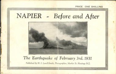
Booklet, Nelson Stedman, Napier Before and After the Earthquake of February 3rd 1931, c1931
The earthquake at Napier, also known as the Hawke's Bay Earthquake, took place on 03 February 1931 at about 10.45 am. There was no warning before the ground started to heave and roll in waves. It was not possible to stand without support, and the violent motion caused stone and brick buildings to collapse into the streets causing death and injury to hundreds who were going about there daily business. Fires started almost immediately, and with the water mains shattered, the fire fighters were powerless to stop or prevent the spread of the flames. Within twelve hours the greater part of the business area of Napier and its port was totally destroyed. As a result of the pressure which caused the upheaval, the levels of the town and the surrounding district have been altered. The town and the harbour were raised from five to seven feet, and many parts of the inner harbour became dry land. Small booklet of 18 pages with photographic comparisons of New Zealand's Napier region before and after the 1931 earthquake.napier, new zealand, earthquake, lovell-smith, stedman, boston, port ahururu, westshore, clive square, hawke's bay -
 Federation University Historical Collection
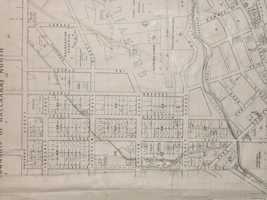
Plan, City of Ballarat (Part) (Ballaarat East), 08/05/1928
Crown Cadastral Plan showing Governement Roads, Crown Parcels, Dimensions, Crown grantees, dated of grants, etc in Ballarat East. The plan shows features such as Bakery Hill, Canadian Station, recreation reserves, timber reserves, Yarrowee Creek, Black Hill Reserve, Eureka Reserve and Garden, Orphan Asylum, Rifle Butts Reserve, Ballarat Woollen Mill, Ballarat Observatory, Sovereign Hill Recreation Reserve, Specimen Vale, Market Reserve, Cemetery WGS 84 Centroid 37 degrees 33' 55" S 143 degrees 52' 38" E E.W. Extent; 5 km N-S Extent; 4 kmmap, plan, ballarat east, ballarat woollen mill, ballarat railway line, ballarat railway station, eureka reserve, eureka cemetery, ballarat orphanage, russell square, bakery hill -
 Federation University Historical Collection
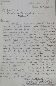
Correspondence, A.M. Greenfield to the Ballarat School of Mines, 1898, 25/04/1898
Handwritten letter from A.M. greenfield to Frederick Martell of the Ballarat School of Mines. a.m. greenfield, market square, ballarat, frederick martell -
![Souvenir - Object, Small plate with gold [Chinese?] dragon, c2010](/media/collectors/4f729f6797f83e0308601707/items/5e32283b21ea67080c6e5e2f/item-media/5e32294921ea67080c6f3920/item-fit-380x285.jpg) Federation University Historical Collection
Federation University Historical CollectionSouvenir - Object, Small plate with gold [Chinese?] dragon, c2010
Small blue plate with gold [Chinese?] dragon in a wooden frame with gold mount.Red oval sticker with Chinese writing bottom right hand corner on the back.plate, gold dragon, wooden frame, gold mount, square