Showing 10667 items
matching businesses.
-
 Marysville & District Historical Society
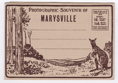
Postcard (item) - Black and white photographs, Barton Bros, Photographic Souvenir of Marysville, 1923-1963
A series of nine black and white photographs of scenic attractions taken in and around Marysville in Victoria that was published by the Barton Bros, Marysville and printed by Valentines Publishing Co as a souvenir of Marysville.A series of nine black and white photographs of scenic attractions taken in and around Marysville in Victoria that was published by the Barton Bros, Marysville, and printed by Valentines Publishing Co as a souvenir of Marysville. Thomas Barton was one of the earliest settlers in Marysville and with 16 children and numerous descendants, the name of Barton is synonymous with Marysville. Thomas John Barton, along with his business partner, Ewen Hugh Cameron, opened a butcher/abattoirs in Marysville in 1864. This was the first shop in Marysville. They supplied meat and other items to the miners along the Woods Point road. Thomas Barton was an active community member and was a key organiser in setting up the school in Marysville in 1870. After Thomas' death in 1911, his sons Fred and Frank took over the family business and renamed it Barton Bros. Name & Address of/ sender allowed on/ cover STAMPS-/ 1d. Common-wealth/ 1 1/2d. British Empire If any Correspond'e/ letter rates postage From Published by BARTON BROS., Marysvillemarysville, victoria, barton bros, acheron way (image 1), keppel's falls (image 2), cumberland falls (image 3), stevenson falls (image 4), taggerty river (image 5), mount margaret (image 6), mount gordan (image 7), nicholl's lookout (image 8), the old ford (image 9), valentine publishing co, souvenir, postcard, thomas barton, ewen hugh cameron, francis adam barton, frederick barton -
 Marysville & District Historical Society
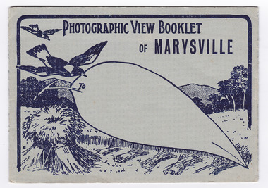
Postcard (item) - Black and white photographs, Barton Bros, Photographic View Booklet of MARYSVILLE, 1923-1963
A series of nine black and white photographs of scenic attractions taken in and around Marysville in Victoria that was published by the Barton Bros, Marysville and printed by Valentines Publishing Co as a souvenir of Marysville.A series of black and white photographs of scenic attractions taken in and around Marysville in Victoria that was published by the Barton Bros, Marysville and printed by Valentines Publishing Co as a souvenir of Marysville. Thomas Barton was one of the earliest settlers in Marysville and with 16 children and numerous descendants, the name of Barton is synonymous with Marysville. Thomas John Barton, along with his business partner, Ewen Hugh Cameron, opened a butcher/abattoirs in Marysville in 1864. This was the first shop in Marysville. They supplied meat and other items to the miners along the Woods Point road. Thomas Barton was an active community member and was a key organiser in setting up the school in Marysville in 1870. After Thomas' death in 1911, his sons Fred and Frank took over the family business and renamed it Barton Bros. To From Published by BARTON BROS., Marysvillemarysville, victoria, barton bros, acheron way (image 1), keppel's falls (image 2), cumberland falls (image 3), stevenson falls (image 4), taggerty river (image 5), mount margaret (image 6), mount gordan (image 7), nicholl's lookout (image 8), the old ford (image 9), postcard, valentine publishing co, souvenir, thomas barton, francis adam barton, frederick barton, ewen hugh cameron -
 Marysville & District Historical Society
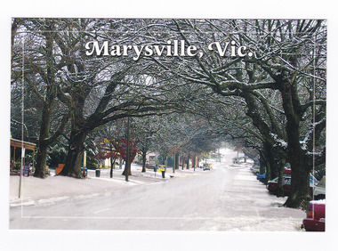
Postcard (item) - Colour postcard, Graphic Print Postcards, Marysville, Vic, 2004
A colour photograph of a snow covered Murchison Street in Marysville in Victoria.A colour photograph of a snow covered Murchison Street in Marysville in Victoria. This photograph was taken in 2004 before the 2009 Black Saturday bushfires that destroyed most of the businesses in the main street.Marysville's main street covered with a light layer of snow. Marysville is a small country town in Victoria, just 10/ minutes from Lake Mountain, one of Australia's best/ Cross Country Skiing Resorts. Graphic in Print/ Postcards Place/ Stamp/ Here Graphic in Print/ Country Towns Collection/ Classic 2/ c 2004/ Ph: (03) 5966 8523 Fax: (03) 5966 8458 Mob: 418 593 534marysville, victoria, murchison street, snow, postcard, souvenir, graphic in print, country town collection -
 Marysville & District Historical Society
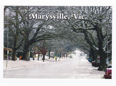
Postcard (item) - Colour postcard, Graphic Print Postcards, Marysville, Vic, 2004
A colour photograph of a snow covered Murchison Street in Marysville in Victoria.A colour photograph of a snow covered Murchison Street in Marysville in Victoria. This photograph was taken in 2004 before the 2009 Black Saturday bushfires that destroyed most of the businesses in the main street.Marysville's main street covered with a light layer of snow. Marysville is a small country town in Victoria, just 10/ minutes from Lake Mountain, one of Australia's best/ Cross Country Skiing Resorts. Graphic in Print/ Postcards Place/ Stamp/ Here Graphic in Print/ Country Towns Collection/ Classic 2/ c 2004/ Ph: (03) 5966 8523 Fax: (03) 5966 8458 Mob: 418 593 534marysville, victoria, murchison street, snow, postcard, souvenir, graphic in print, country town collection -
 Marysville & District Historical Society
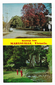
Postcard (item) - Colour postcard, Rose Stereograph Company, Greetings from MARYSVILLE, Victoria, Pre 2009
A postcard with two colour photographs taken in Marysville in Victoria.A postcard with two colour photographs taken in Marysville in Victoria. The top photograph was taken on the corner of Murchison Street and Pack Road and shows an iconic wooden direction sign. The other is taken along the Steavenson River in Marysville. Murchison Street is Marysville's main street and is where most of the businesses in Marysville are. This postcard was produced by the Rose Stereograph Co as a souvenir of Marysville. Rose Series Colorview No. 348.POST CARD The "Rose" Series/ De Luxe Produced in Australia Signpost Corner At Marysville, Victoria. Stevenson's River, Marysville, Victoria Rose Series Colorview No. 348 Published by the Roe Stereograph Co., Armadale, Victoria.marysville, victoria, signpost, steavenson river, rose stereograph co, postcard, souvenir -
 Flagstaff Hill Maritime Museum and Village
Print - Lithoprint
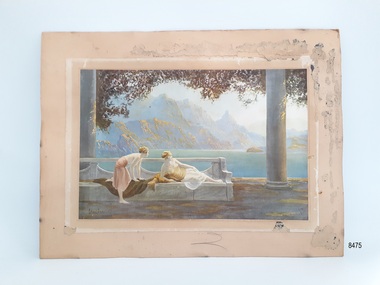
This art work is an example of an Art Deco print created through lithoprint / lithograph techniques. As a print it would have been more affordable than an original artwork and hence could be purchased by a wider cliental. Little is known about the artist, but Jean Lasalle is listed as producing another print used by Tuck & Sons in their Oilette postcard series.This item is significant socially as an example of artwork that may have been displayed in homes around the 1910s- 1930s. The Oilette logo carries significance, linking the print to a business that was influential in the early production of postcards.Unframed print on board with some framing tacks still attached to the back of the board. Print area is in fair condition. The print has been stuck to a ‘paper frame' which has been attached to the backing board. The subject of the print is a lake view, with steep mountains in the background and two female figures on a bench in the foreground in the Art Deco style. Colours are muted. The print has the artist's signature 'Jean Lasalle' (looking at the print bottom left) and the words 'Oilette' (looking at the print bottom right) with a small logo composed of an oval and square underneath.flagstaff hill, warrnambool, maritime village, maritime museum, flagstaff hill maritime museum & village, shipwreck coast, great ocean road, lithoprint, lithograph, oilette, golden dawn, art deco, jean lasalle, print, day dream -
 Flagstaff Hill Maritime Museum and Village
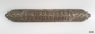
Equipment - Foot Grip, Frank McDowell, Early 20th century
This foot grip was made and owned by Frederick William McDowell (Fred) (1880 to 15-6-1967). It would be been joined to the stafe or frame of a jinker and used to step up from the ground and onto the seat. He was a wheelwright by trade. He made and repaired vehicles such gigs, buggies, jinkers, sulkeys, spring carts and farm wagons. His workshop was on the corner of Cramer Street and Raglan Parade in Warrnambool., previously the site of Fotheringhams, and after McDowell's, and still in 2023, occupied by Reece Plumbing Fred's workplace prior to retiring was at Bryant & Waterson's in Kepler Street, opposite the Criterian Hotel, making rubber tyred horse-driven farm wagons.This jinker's foot grip id part of a jinker or two-wheeled carriage. It is a rare item, made by a local wheelwright Frank McDowell who operated his buggy making and repair business in Warrnambool's CBD in the early twentieth century. It is an example of the equipment used on horse-drawn vehicles for safety and convenience.Foot grip, iron with silver plate finish. Rectangular metal plate with textured crossed over diagonal lines on the top surface and inset rectangles with impressed text. the curved and shaped ends have a drilled round hole. the length of the plate is an inverted 'v' shape towards the base. Made by F. McDowell, Warrnambool."F McDOWELL" "WARRNAMBOOL"flagstaff hill, warrnambool, flagstaff hill maritime museum, maritime museum, shipwreck coast, flagstaff hill maritime village, great ocean road, fred mcdowell, frederick mcdowell, wheelwright, gig, buggy, jinker, sulkey, spring cart, farm wagon, 2-wheeled cart, horse cart, horse cart parts, jinker buggy, transport, vehicle, horse drawn, horse jinker, bryant & waterson, jinker part, jinker foot grip, step, foot plate, horse cart part, stafe, 2-wheeled carriage -
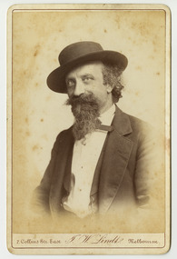
 Marysville & District Historical Society
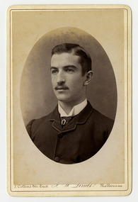
Photograph (Item) - Black and white portrait, John William Lindt, 1870s
A black and white portrait of an unknown man taken by John William Lindt.A black and white portrait of an unknown man taken by John William Lindt. John William Lindt was born in Germany in 1845. At 17 he took a working passage to Australia on a Dutch sailing ship. Taking up work as an itinerant piano-tuner, he traveled amongst towns in Victoria and New South Wales before settling in Grafton in 1863 where he became assistant and apprentice to photographer Conrad Wagner. After a brief return to Germany in 1867 Lindt took over management of Wagner’s studio in 1869. He married Wagner’s daughter, Anna on 13 January 1872. Over 1873-1874, using the slow and laborious wet-plate collodion process, John Lindt produced photographs of the local indigenous people both in their environment conducting actual traditional ceremonies in the Clarence River district, and in his studio. Twelve of this series is included in his 1874 album Australian Aboriginals. John Lindt moved to Melbourne in 1876 where he worked for Batchelder & Co. before opening his own opulent studios at number 7 at the top of Collins Street opposite the Treasury, in 1877. John Lindt's business of this period was wide-ranging, and included portraits, records of Melbourne public buildings and streetscapes, the Botanical Gardens, and Port Melbourne. He was a welcome photographer of members of parliament and other Melbourne personalities, their society and cultural life including the theatre, and was known as a ‘rich man’s photographer’ for those whose families he grouped informally on the lawns in front of their mansions, with servants at the rails of the upstairs balconies. He continued with landscape, producing folios Fernshaw and Watt River Scenery, Victoria ( c.1878-82), Scenery on the Ovens and Buckland Rivers, Victoria (c.1878–82) and Lorne, Louttit Bay and Cape Otway Ranges (1883). Sales of his Black Spur scenery amounted to approximately 25,000 copies printed from the original negatives between 1882 and 1892. John Lindt, in collaboration with Nicholas John Caire, produced a tourist booklet on the area around "The Hermitage" in 1913.7 Collins Str. East/ J.W. Lindt/ Melbournejohn william lindt, conrad wagner, australian aboriginals, batchelder & co, nicholas john caire, anna lindt -
 Marysville & District Historical Society
Photograph (Item) - Black and white portrait, John William Lindt, 1870s
A black and white portrait of an unknown man taken by John William Lindt.A black and white portrait of an unknown man taken by John William Lindt. John William Lindt was born in Germany in 1845. At 17 he took a working passage to Australia on a Dutch sailing ship. Taking up work as an itinerant piano-tuner, he traveled amongst towns in Victoria and New South Wales before settling in Grafton in 1863 where he became assistant and apprentice to photographer Conrad Wagner. After a brief return to Germany in 1867 Lindt took over management of Wagner’s studio in 1869. He married Wagner’s daughter, Anna on 13 January 1872. Over 1873-1874, using the slow and laborious wet-plate collodion process, John Lindt produced photographs of the local indigenous people both in their environment conducting actual traditional ceremonies in the Clarence River district, and in his studio. Twelve of this series is included in his 1874 album Australian Aboriginals. John Lindt moved to Melbourne in 1876 where he worked for Batchelder & Co. before opening his own opulent studios at number 7 at the top of Collins Street opposite the Treasury, in 1877. John Lindt's business of this period was wide-ranging, and included portraits, records of Melbourne public buildings and streetscapes, the Botanical Gardens, and Port Melbourne. He was a welcome photographer of members of parliament and other Melbourne personalities, their society and cultural life including the theatre, and was known as a ‘rich man’s photographer’ for those whose families he grouped informally on the lawns in front of their mansions, with servants at the rails of the upstairs balconies. He continued with landscape, producing folios Fernshaw and Watt River Scenery, Victoria ( c.1878-82), Scenery on the Ovens and Buckland Rivers, Victoria (c.1878–82) and Lorne, Louttit Bay and Cape Otway Ranges (1883). Sales of his Black Spur scenery amounted to approximately 25,000 copies printed from the original negatives between 1882 and 1892. John Lindt, in collaboration with Nicholas John Caire, produced a tourist booklet on the area around "The Hermitage" in 1913.7 Collins Str. East/ J.W. Lindt/ Melbournejohn william lindt, conrad wagner, australian aboriginals, batchelder & co, nicholas john caire, anna lindt -
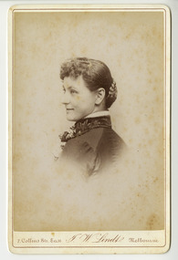 Marysville & District Historical Society
Photograph (Item) - Black and white portrait, John William Lindt, 1870s
A black and white portrait of an unknown woman taken by John William Lindt.A black and white portrait of an unknown woman taken by John William Lindt. John William Lindt was born in Germany in 1845. At 17 he took a working passage to Australia on a Dutch sailing ship. Taking up work as an itinerant piano-tuner, he traveled amongst towns in Victoria and New South Wales before settling in Grafton in 1863 where he became assistant and apprentice to photographer Conrad Wagner. After a brief return to Germany in 1867 Lindt took over management of Wagner’s studio in 1869. He married Wagner’s daughter, Anna on 13 January 1872. Over 1873-1874, using the slow and laborious wet-plate collodion process, John Lindt produced photographs of the local indigenous people both in their environment conducting actual traditional ceremonies in the Clarence River district, and in his studio. Twelve of this series is included in his 1874 album Australian Aboriginals. John Lindt moved to Melbourne in 1876 where he worked for Batchelder & Co. before opening his own opulent studios at number 7 at the top of Collins Street opposite the Treasury, in 1877. John Lindt's business of this period was wide-ranging, and included portraits, records of Melbourne public buildings and streetscapes, the Botanical Gardens, and Port Melbourne. He was a welcome photographer of members of parliament and other Melbourne personalities, their society and cultural life including the theatre, and was known as a ‘rich man’s photographer’ for those whose families he grouped informally on the lawns in front of their mansions, with servants at the rails of the upstairs balconies. He continued with landscape, producing folios Fernshaw and Watt River Scenery, Victoria ( c.1878-82), Scenery on the Ovens and Buckland Rivers, Victoria (c.1878–82) and Lorne, Louttit Bay and Cape Otway Ranges (1883). Sales of his Black Spur scenery amounted to approximately 25,000 copies printed from the original negatives between 1882 and 1892. John Lindt, in collaboration with Nicholas John Caire, produced a tourist booklet on the area around "The Hermitage" in 1913.7 Collins Str. East/ J.W. Lindt/ Melbournejohn william lindt, conrad wagner, australian aboriginals, batchelder & co, nicholas john caire, anna lindt -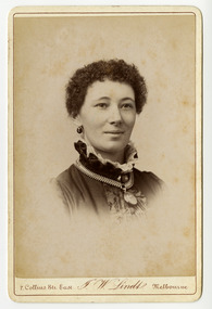
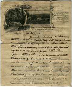 Marysville & District Historical Society
Letter (Item) - Hand written letter, John William Lindt, 1903
A letter written to Maurice Keppel by John William Lindt in 1903.A letter written to Maurice Keppel by John William Lindt in 1903. John William Lindt was born in Germany in 1845. At 17 he took a working passage to Australia on a Dutch sailing ship. Taking up work as an itinerant piano-tuner, he traveled amongst towns in Victoria and New South Wales before settling in Grafton in 1863 where he became assistant and apprentice to photographer Conrad Wagner. After a brief return to Germany in 1867 Lindt took over management of Wagner’s studio in 1869. He married Wagner’s daughter, Anna on 13 January 1872. Over 1873-1874, using the slow and laborious wet-plate collodion process, John Lindt produced photographs of the local indigenous people both in their environment conducting actual traditional ceremonies in the Clarence River district, and in his studio. Twelve of this series is included in his 1874 album Australian Aboriginals. John Lindt moved to Melbourne in 1876 where he worked for Batchelder & Co. before opening his own opulent studios at number 7 at the top of Collins Street opposite the Treasury, in 1877. John Lindt's business of this period was wide-ranging, and included portraits, records of Melbourne public buildings and streetscapes, the Botanical Gardens, and Port Melbourne. He was a welcome photographer of members of parliament and other Melbourne personalities, their society and cultural life including the theatre, and was known as a ‘rich man’s photographer’ for those whose families he grouped informally on the lawns in front of their mansions, with servants at the rails of the upstairs balconies. He continued with landscape, producing folios Fernshaw and Watt River Scenery, Victoria ( c.1878-82), Scenery on the Ovens and Buckland Rivers, Victoria (c.1878–82) and Lorne, Louttit Bay and Cape Otway Ranges (1883). Sales of his Black Spur scenery amounted to approximately 25,000 copies printed from the original negatives between 1882 and 1892. John Lindt, in collaboration with Nicholas John Caire, produced a tourist booklet on the area around "The Hermitage" in 1913. Maurice Keppel, from Ireland, was one of the first landholders in the newly surveyed town of Marysville in 1864. He and his wife ran the successful Keppel’s Australian Hotel. Two of their sons, John and Jerry, established a farm and opened up the surrounding high country. The Keppel lease was one of the longest held in the high country and the Keppel Family were amongst Marysville's pioneering families.maurice keppel, keppel family, keppel's australian hotel, marysville, victoria, john william lindt, conrad wagner, australian aboriginals, batchelder & co, nicholas john caire, anna lindt -
 Marysville & District Historical Society
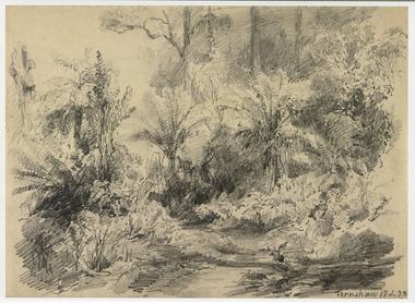
Artwork, other (Item) - Pencil Sketch, Louis Buvelot, Fernshaw 17.2.83, 1883
A copy of an early pencil sketch of Fernshaw in Victoria.A copy of an early pencil sketch of Fernshaw in Victoria by Louis Buvelot. Louis Buvelot ( 1814–1888), born Abram-Louis Buvelot, was a Swiss landscape painter who lived 17 years in Brazil and following 5 years back in Switzerland stayed 23 years in Australia, where he influenced the Heidelberg School of painters. Arriving in Melbourne in February 1865, after leaving the cold of Switzerland, which was impacting on his health, for the warmth of Australia, Buvelot was in business as a photographer in Bourke Street for a year but soon resumed his painting. He lived in Melbourne for a number of years before moving to Fitzroy. The National Gallery of Victoria purchased two of his paintings and he continued painting until his death in 1888. He was buried at the Boroondara Cemetery, where a large monument was erected in his memory. Fernshaw was a rural township 63 km northeast of Melbourne and 10 km northeast of Healesville. Situated on the Watts River, near where a log had fallen making a convenient crossing, Fernshaw was settled in the 1860s. It provided good country for orchards and berry growing. The location was at the foot of Blacks Spur, with Mounts Juliet and Mondah rising on either side, providing spectacular scenery. There were nearby fern gullies giving rise to the name – ‘shaw’ is old English for thicket or wood. By 1875 Fernshaw had a post office (1865), two hotels, a school (1871), and stores. It was famed for its beauty, attracting tourists. In 1886 the Melbourne and Metropolitan Board of Works began work on the Watts River water catchment scheme – later to become Maroondah – and the Board obtained approval for the catchment country to be reserved and kept free of settlement. This required the removal of the Fernshaw township, which was completed by about 1890.Fernshaw 17.2.83louis buvelot, fernshaw, victoria, national gallery of victoria, switzerland, boroondara cemetery, kew cemetery, artist -
 Marysville & District Historical Society
Painting (Item) - Oil painting, Isaac Whitehead, A spring morning near Fernshaw 1880, 1880
A copy of an early oil painting of Fernshaw in Victoria.A copy of an early oil painting of Fernshaw in Victoria by Isaac Whitehead. Isaac Whitehead (1819–1881) was an Irish-Australian artist who worked in watercolour and pastel. He was also a picture framer and art promoter. It is believed that Isaaz Whitehead emigrated to Australia with his family in either 1853 or 1858. Isaac Whitehead died at his home 50 Punt Road, Prahran, Melbourne, on 21 April 1881. Isaac Whitehead had established himself as the foremost picture framer in Melbourne by 1860, known for his highly ornate frames with floral decorations. Among the clients of his framing business were Louis Buvelot, Nicholas Chevalier, and Eugene von Guérard. In his own paintings, he painted a number of scenes of the forests of Gippsland, Victoria. His work focused on the rich landscapes with trees and ferns, with a high degree of botanical detail. His work won him two medals and his work was posthumously exhibited at 1884 Victorian Jubilee Exhibition, the 1886 London Colonial and Indian Exhibition, and the 1888 Melbourne Centennial Intercolonial Exhibition. Fernshaw was a rural township 63 km northeast of Melbourne and 10 km northeast of Healesville. Situated on the Watts River, near where a log had fallen making a convenient crossing, Fernshaw was settled in the 1860s. It provided good country for orchards and berry growing. The location was at the foot of Blacks Spur, with Mounts Juliet and Mondah rising on either side, providing spectacular scenery. There were nearby fern gullies giving rise to the name – ‘shaw’ is old English for thicket or wood. By 1875 Fernshaw had a post office (1865), two hotels, a school (1871), and stores. It was famed for its beauty, attracting tourists. In 1886 the Melbourne and Metropolitan Board of Works began work on the Watts River water catchment scheme – later to become Maroondah – and the Board obtained approval for the catchment country to be reserved and kept free of settlement. This required the removal of the Fernshaw township, which was completed by about 1890.isaac whitehead, fernshaw, victoria, louis buvelot, nicholas chevalier, eugene von guerard, gippsland, victorian jubilee exhibition, london colonial and indian exhibition, melbourne centennial intercolonial exhibition, watts river, healesville, blacks spur, mount juliet, mount mondah -
 Bunjil Park Aboriginal Education & Cultural Centre
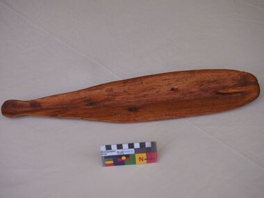
Woomera
A hunter uses this tool to throw a spear in front of a fleeing animal, skillfully intercepting it so that it is speared on the run. The size of the groove and spear holder indicate this woomera was made for light weight hunting spears not for warfare. Elders and young warriors carried these with them and each man made his own to suite his strength and body size. They were used when the need and opportunity for fresh meat arose. Woomeras were used by men.This is the only Jaara woomera in the collection and is a significant tool used in the on going search for food. It is a mens tool.This woomera is undecorated. At the broad end there is a small hook like protrusion which holds the spear in place before throwing. The narrow end has a tapered waist with bulb to assist grip and a shallow groove to help guide the spear. The overall shape is an elongated hollowed single piece of timber.There are no inscriptions, the wood is strong with a prominent grain pattern.wood, jaara, tool, woomera, throwing stick, mens business, hunting -
 Eltham District Historical Society Inc
Photograph, Fred Mitchell, Fuel advertsiement sign on timber fence of A.R. Warren's Fuel Merchant business, Main Road, Eltham, 1968, 1968
Eltham Feed store visible on other side of fence (south side).Digital copy of colour photographfred mitchell collection, 1968, fuel merchant, a.r. warren, eltham feed store, main road, advertisements -
 Glen Eira Historical Society
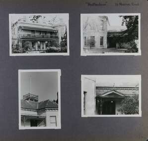
Album - Album page, Heatherbrae, 73 Neerim Road, Circa 1972
This photograph is part of the Caulfield Historical Album 1972. This album was created in approximately 1972 as part of a project by the Caulfield Historical Society to assist in identifying buildings worthy of preservation. The album is related to a Survey the Caulfield Historical Society developed in collaboration with the National Trust of Australia (Victoria) and Caulfield City Council to identify historic buildings within the City of Caulfield that warranted the protection of a National Trust Classification. Principal photographer thought to be Trevor Hart, member of Caulfield Historical Society. Most photographs were taken between 1966-1972 with a small number of photographs being older and from unknown sources. All photographs are black and white except where stated, with 386 photographs over 198 pages.From Victorian Heritage Database citation for Heatherbrae HO46 https://vhd.heritagecouncil.vic.gov.au/places/120933 (as at 28/10/2020) "Heatherbrae" at 73 Neerim Road, Glenhuntly, is a substantial Victorian residential complex made up of two principal construction stages (pre 1876 and c. 1890) and outbuildings including stables. It is aesthetically, historically and socially significant. Its aesthetic value is demonstrated by the manner in which the two periods of construction survive, the earliest being of greater architectural interest on account of its tower and facade treatment, the latter phase adopting a common villa form. The importance of the complex is heightened by its intact state and surviving outbuildings. "Heatherbrae's" historical significance lies in its link with locally known business man and Shire of Caulfield councillor, John Charles Holland. Its social value rests on its ability to demonstrate a past lifestyle.Page 142 of Photograph Album with four photographs (three landscape, one portrait) of Heatherbrae on Neerim Road.Handwritten: "Heatherbrae" 73 Neerim Road [top right] / 142 [bottom right]trevor hart, verandah, chimneys, decorative brackets, cast iron columns, return verandah, garden, 1870's, intricate lacework, neerim road, booran road, 1880's, 1890's, mansion, john c. holland, bluestone foundations, italianate, iron roofed balcony, cast iron balustrade, balcony, ornamented pediment, mosaic tiles, cast iron lookout, flagpole, george f griffiths, mcgowan, tower, caulfield, heatherbrae, cast iron work, victorian style, john holland, porte-cochere porches, lead lights, george griffiths, mansions, stables, councillors, outbuildings -
 Glen Eira Historical Society
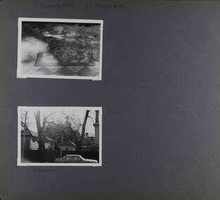
Album - Album page, Heatherbrae, 73 Neerim Road, Circa 1972
This photograph is part of the Caulfield Historical Album 1972. This album was created in approximately 1972 as part of a project by the Caulfield Historical Society to assist in identifying buildings worthy of preservation. The album is related to a Survey the Caulfield Historical Society developed in collaboration with the National Trust of Australia (Victoria) and Caulfield City Council to identify historic buildings within the City of Caulfield that warranted the protection of a National Trust Classification. Principal photographer thought to be Trevor Hart, member of Caulfield Historical Society. Most photographs were taken between 1966-1972 with a small number of photographs being older and from unknown sources. All photographs are black and white except where stated, with 386 photographs over 198 pages.From Victorian Heritage Database citation for Heatherbrae HO46 https://vhd.heritagecouncil.vic.gov.au/places/120933 as at (28/10/2020) "Heatherbrae" at 73 Neerim Road, Glenhuntly, is a substantial Victorian residential complex made up of two principal construction stages (pre 1876 and c. 1890) and outbuildings including stables. It is aesthetically, historically and socially significant. Its aesthetic value is demonstrated by the manner in which the two periods of construction survive, the earliest being of greater architectural interest on account of its tower and facade treatment, the latter phase adopting a common villa form. The importance of the complex is heightened by its intact state and surviving outbuildings. "Heatherbrae's" historical significance lies in its link with locally known business man and Shire of Caulfield councillor, John Charles Holland. Its social value rests on its ability to demonstrate a past lifestyle. Page 143 of Photograph Album with 2 landscape photographs of Heatherbrae on Neerim Road - paving insignia and side view.Handwritten: "HEATHERBRAE" 73 NEERIM ROAD [top] / STABLE [under bottom photo] / 143 [bottom left]trevor hart, chimneys, cast iron columns, return verandah, garden, 1870's, neerim road, booran road, 1880's, 1890's, mansion, john c. holland, bluestone foundations, italianate, iron roofed balcony, cast iron balustrade, mosaic tiles, cast iron lookout, flagpole, george f griffiths, residential villa, caulfield, heatherbrae, victorian style, cast iron work, stables, outbuildings, john holland, george griffiths, councillors, mansions -
 Glen Eira Historical Society
Album - Album page, Grimwade House, Orrong Road, Circa 1972
This photograph is part of the Caulfield Historical Album 1972. This album was created in approximately 1972 as part of a project by the Caulfield Historical Society to assist in identifying buildings worthy of preservation. The album is related to a Survey the Caulfield Historical Society developed in collaboration with the National Trust of Australia (Victoria) and Caulfield City Council to identify historic buildings within the City of Caulfield that warranted the protection of a National Trust Classification. Principal photographer thought to be Trevor Hart, member of Caulfield Historical Society. Most photographs were taken between 1966-1972 with a small number of photographs being older and from unknown sources. All photographs are black and white except where stated, with 386 photographs over 198 pages. From Victorian Heritage Database citation HO54 Grimwade House, former Harleston stables, outbuilding, garden, gate and Picconia excelsa tree. https://vhd.heritagecouncil.vic.gov.au/places/35573 as at (28/10/2020) ''Harleston'', now "Grimwade House", is situated at no. 67 Balaclava Road, Caulfield North, at the Orrong Road corner. It was built for Frederick, later Sir Frederick, Grimwade, to the design of architect Thomas Watts in 1875. Today the complex has been incorporated in the Melbourne Grammar Junior School campus. It retains not only the main house but also the stables and mature garden setting with driveway and gates. It is historically, aesthetically and socially significant.From Victorian Heritage Database citation HO54 Grimwade House, former Harleston stables, outbuilding, garden, gate and Picconia excelsa tree. https://vhd.heritagecouncil.vic.gov.au/places/35573 as at (28/10/2020) It is historically significant (Criterion A) as the former home of prominent business man, speculator and benefactor, Sir Frederick Grimwade. Both Grimwade and his house are exemplars of the commercial enterprise of the Boom period and the amassing of personal fortunes with which it is associated. It is aesthetically significant (Criterion E) as an imposing yet stately large house of its time, the classic Italian form with comer verandah terminated by projecting wings being most distinctively seen in this instance. It is enhanced not only by the garden setting but also by the delicate cast iron verandah spandrels, stained glass work and stencilled ceiling in the music room. It is socially significant (Criterion G) on account of the value placed on it by the community associated with the Melbourne Grammar Junior School since its inception on this site in 1911.Page 154 of Photograph Album with five photographs (4 landscape and one portrait) including Grimwade House, gates and a tram shelter.Handwritten: Grimwade House (Melbourne Grammar Prep School) / incorporating "Harleston" Orrong Rd. S.E cnr Balaclava Rd [top right] / 154 [bottom right]trevor hart, verandah, porch, slate roof, garden, grimwade house, grimwade, harleston, sir frederick grimwade, thomas watts, orrong road, balaclava road, melbourne grammar, melbourne grammar junior school, italianate, cast iron verandah spandrels, stained glass, stencilled ceiling, mgs, m.g.s, school, grimwade family, jessie grimwade, gates, palisade style fence, cast iron spears, stone plinths, melbourne grammar prep school, victorian style, cast iron work, caulfield north, gardens, cars, tram services, outbuildings, stables, trees, picconia excelsa tree -
 Glen Eira Historical Society
Document - NEERIM ROAD RAILWAY CROSSING AND GATES GLEN HUNTLY
This file contains two items: 1/Twelve photographs of the Glen Huntly, Neerim Road hand-operated railway gates, dated 1983 and November 1985, photographer unknown, and two black and white copies of two of the original photographs. Four photographs are in black and white and eight are in colour, all picturing the Gatekeeper’s shelter and/or the railway gates. Six photographs dated 1985 include the Gatekeeper, unidentified, in some photos operating the gates. 2/A three-page pamphlet dated 03/05/1979 promoting a public meeting at the Caulfield Town Hall to debate Road Grade Separation proposals for the Neerim Road and Glenhuntly Road railway crossings. Document details the proposed VicRail improvement and four alternative improvements as we as a blank questionnaire for the submission of ideas regarding the proposals to the Caulfield City Council Urban Planner. A short summary of other concerns held by two councillors and an engineer regarding the proposal is also included, as is a Railway Noise Level. Railway Pamphlet also includes a map of the area surrounding the railway crossings under discussion 1977.glenhuntly road, neerim road, caulfield, railway gates, gates, hand-operated railway gates, railways, roads and streets, railway crossings, architectural features, town halls, official buildings, vicrail, meetings, public meetings, caulfield town hall, gatekeepers, caulfield city council, elsternwick, glen huntly, caulfield park, caulfield racecourse, normanby road, dandenong road, railway buildings, railway stations, land transport, transport establishments, hordern a.g., dunstan don, hordern bill, needham j.g., advertisements, graphics, advertising, advertising signs, signs, estate agents, business people, stockdale and leggo, buildings structures and establishments, occupations, united signs, signs, communication devices, motor vehicles, glenhuntly railway station, town planning, civic and landscape art, engineers, professionals, traffic, road transport, transport, maps, documents, plans -
 Glen Eira Historical Society
Book - CAULFIELD CENTENARY 1957
This file contains four items 1/Two copies of a twenty-four page booklet titled CITY OF CAULFIELD CENTENARY 1857-1957, created by the Caulfield City Council and printed by Peter Isaacson Pty Limited, Melbourne. The booklet details important aspects of Caulfield’s history including council procedures, the Caulfield Road District Proclamation, the first election and a summary of 100 years of local government with a description of the present Caulfield in 1957. The booklet also includes several pictures of various Caulfield landmarks and people including one of Caulfield City Councillors (11 men and 1 woman). Also one photocopied version of this booklet. 2/Eleven pages of typed notes for the City of Caulfield Centenary booklet. All notes are undated and incomplete. Two pages titled NOTES on THE HISTORY and PROGRESS OF THE CITY OF CAULFIELD, author unknown. Three and a half pages titled THE STRUCTURE OF LOCAL GOVERNMENT IN VICTORIA, author unknown. Five pages titled 100 YEARS OF LOCAL GOVERNMENT – EARLY CAULFIELD, by Mrs A. P. Bell. 3/A typed letter to Miss V. Webb-Langdon from the Town Clerk H.G. Nelson, acknowledging her contribution to historical details for the Caulfield Council’s Centenary booklet, dated 24/12/1957. 4/A handwritten letter and a handwritten note regarding the acquisition of notes for the Caulfield Centenary booklet. The letter is dated 03/08/2006 and the note is dated 09/02/2007.city of caulfield centenary, caulfield road district, sinclair a.j.g., city hall, war memorials, gamble h.a., machin l.r., bunny f.c.d., caulfield park, koornang reserve, parton e.m., sims h.e., thomson w.r., gunn e.e., yorston j.s., wallace g.e. mrs, green w.c., jenner e.r., ward boundaries, dandenong road, queens avenue, normanby road, station street, bond street, glen eira road, orrong road, poath road, north road, booran road, nepean highway, glen huntly road, glenhuntly road, inkerman road, hotham street, nelson h.g., fullard w.r., mackley g.j., ellis k.i, crosbie m.r., nutting b.i., body j.h., pritchard r.j., guildford l.t.g., lund l.m., street h.c., reynolds a.w., elections , political processes, local government, springthorpe reserve, greenmeadows gardens, business and finance, roads and streets, caulfield racecourse, east caulfield reserve, mackinnon reserve, hawthorn road, balaclava road, murrumbeena road, lempriere avenue, victoria street, koornang road, lord reserve, lyons street, murrumbeena reserve, kangaroo road, ormond park, beatty crescent, foch street, packer reserve, oakleigh road, leila road, prices park, bambra road, riley reserve, playgrounds, town hall, maternal and child health centres, truganini road, grange road, senior citizens centre, barkley sir henry, moore david, handasyde gilbert, caulfield school room, harris g.w., semple john, dempsey william, brooks w.a., wilson thomas, lyall william, murrum murrumbeen lifestyle, ‘greenmeadows’ house, lempriere family, aboriginal culture, ‘rippon lea’ house, caulfield john, ‘slaney’s’ home, alma road, paddy’s swamp, racecourse hotel, caulfield technical college, bevan mr., ‘grosmont’, hart john, railways, mansions, ‘rosecraddock’, langdon h. j., caulfield cup, ‘crotonhurst’, webb judge, ‘kilwinning’, service james, ricketson henry, ‘glen eira’, house names, garden vale, ross william murray, ‘ross’s folly’, outer circle railway, caulfield grammar school, davies j. henry, lagdon william, grimwade f.s., loyd charles du plan, hope george, ‘airdrie’, kooyong hill, market gardens, dairies, lady talbot milk supply, jenner family, o’niell college, presentation sisters, glenferrie road, grimwade frederick sheppard, grimwade alice, ‘harlston’, grimwade house, ‘saint aubin’s’, ‘st. aubin’s’, ‘caulfield hall’, caulfield john p.t., st georges road, caulfield military hospital, nursing homes, health establishments, dover street, sports and recreations, rosanna street, ‘cantala’, health services, parks and reserves, community services, town planning, local government finance, local officials and employees -
Glen Eira Historical Society
Letter - Elsternwick Mechanics Institute and Public Library
This file contains four items: 1/An undated and unsigned receipt for stocks from the Melbourne branch of the English, Scottish and Australian Bank Limited. Elsternwick Mechanic Institute has been handwritten in ink on the top right-hand corner. 2/Two stock certificates issued by the English, Scottish and Australian Bank Limited to the Elsternwick Mechanics Institute and Public Library on the 18/06/1908. One is a Preferred Inscribed Deposit Certificate No.4354 and the other is a Debenture Stock Certificate No.10.947. both for the amount of fifteen pounds. 3/A typed letter to the Branch Inspector, Melbourne from the Elsternwick Mechanics Institute and Public Library regarding the stock certificates. The letter is dated 25/06/1930. 4/A typed letter dated 10/01/1962 to the General Manager’s Accountant from the Elsternwick Mechanics Institute and Public Library regarding Deposit Stocks.elsternwick mechanics institute and public library, elsternwick, caulfield historical society, elsternwick branch, williams j. d., urquhart a., banking, documents, matthews percy, clubs and associations, financial documents, mechanics institute, the english scottish and australian bank limited, bank personnel, bank managers, commercial establishments, business and finance, educational and research establishments -
 Glen Eira Historical Society
Letter - Glen Huntly Festivals
This file contains five items: 1/An official programme for the Glenhuntly Traders Association’s Annual Christmas Festivals on 22/11/1986. 2/A handwritten letter from Vice President Kaye Georgiades of the Glenhuntly Traders Association to Mr. Balentine thanking him for photos lent. The letter is undated. 3/A typed letter from the Glenhuntly Traders Association to Mr. R. Ballantyne of the Caulfield Historical Society thanking him for helping and supporting the Festival and Payment Art Competition. Dated 30/10/1986. 4/Two typed letters from the Glenhuntly Traders Association to Mr. Ballantyne of the Caulfield Historical Society regarding planned activities for the 1986 and 1987 Christmas Festivals. 5/A black-and-white photograph of members of the Glenhuntly Traders Association, including Gus Theobold pictured on the left. The photo is undated and was published in the Caulfield Contact newspaper.glenhuntly traders, glenhuntly traders associations, caulfield festival, glenhuntly road, booran road, grange road, caulfield, watsons grove, glenhuntly newsagency, royal avenue, campbell j., farey j. mr., manchester grover, mayors, ryall m., caulfield historical society, glenhuntly bowling club, caulfield grammar band, caulfield baton twirlers, glenhuntly christmas festival, glenhuntly festival, truscott v., balentine mr., ballantyne r. mr., truscott v. mrs., neville street, carnegie, georgiades kaye, ford p., glenhuntly, glen huntly, glenhuntly pavement art festival, truscott vanessa, georgiades k., caulfield contact, theobold gus, glenhuntly shopping centre, local government, local officials and employees, associations, historical societies, bowling clubs, festivals and celebrations, festivities, musical ensembles, educational and research establishments, schools, business people, competitions, art competitions, commercial events and activities, officer workers, shows and exhibitions -
 Glen Eira Historical Society
Document - Melbourne and Metropolitan Board of Works
This file contains five items relating to Caulfield Council Visits with the Melbourne & Metropolitan Board of Works (MMBW) from 1919 to circa 1974: 1/A photo album containing photos from the MMBW ‘visit to the Headworks, Yan Yean Water Supply, Wallaby and Silvery Creeks’ from 28/02/1919 to 03/03/1919, attended by members of the Caulfield City Council. The album contains 13 original black-and-white photographs, 3 of which are of the council members. The album is accompanied by a report by Felicitie Campbell, written 11/2008, about these visits. 2/A publication from the MMBW documenting its review of operations for 1973-1974. The report contains information about water supply, sewerage and drainage infrastructure completed or in progress during this period including infrastructure in Caulfield, Ormond, Carnegie and Bentleigh. 3/A periodical feature from the MMBW titled ‘Living City’, issue no. 16, Spring/Summer 1974. Included in the article titled ‘Program’ is a notice that construction will continue on the Elster Creek drain from Thomas St. to Wheatley Road, McKinnon. The periodical also includes the names of commissioners W. R. Walters from Caulfield and G. R. Bricker from Moorabbin (back cover). 4/2 maps and 1 information booklet from the Thomson Project Open Day attended by Felicite and John Campbell as representatives of the Caulfield City Council. This was an annual MMBW open date. Date unknown. 5/Resarch notes by Kate Aldred about the photo album and Thomson Project Open Day booklet and their links to Felicite Campbell 01/04./2014.koornang road, draper street, hall street, centre road, brewers road, caulfield intercepting sewer, byron street, caulfield park, elster creek, caulfield, carnegie, ormond, bentleigh, thomas street, brighton east, wheatley road, mckinnon, city of caulfield, bricker g. r., walters w. r., caulfield city council, melbourne and metropolitan board of works, hall councillor, murray councillor, murphy councillor, wharington councillor, phillips councillor, blyth councillor, best robert sir, reid doctor, jowett mr., wooley mr., hindle mr., annual reports, water supply structures and establishments, sewerage and sanitation, sewerage establishments, drainage, town planning, business and finance, councillors, mayors, acqueducts, dams and reservoirs, creeks, waterfalls, rivers, construction sites, north road, north road pumping station, cities and towns, campbell felicitie -
Glen Eira Historical Society
Book - MOORABBIN
... Businesses ...One item about Moorabbin: 1/An A4 directory of services, clubs, organisations, amenities, sport and recreation facilities, and associations within the Moorabbin City Council’s locality. It has been produced by the City Council in 1987directories, city of moorabbin, sports and recreations, establishment, clubs, local government, clubs and associations, sport and recreation, service clubs, businesses, sporting, social services, social clubs, community services, community centres, community groups, community organisations, east ormond, south oakleigh, moorabbin, patterson, mckinnon, ormond, bentleigh, bentleigh east -
Glen Eira Historical Society
Document - AUSTRALIAN BI-CENTENARY 1788-1988
This file contains a photocopy of an article in the Bi-centenary 88 Newsletter Vol7 No3, October 1987 referring to the mansion Labassa. The article states that the Labassa Mansion will receive funding under the A Gift to the Nation program – a Bi-Centenary project.houses, mansions, labassa, historic buildings, historic events, festivals and celebrations, australian bi-centenary, business and finance, grants, a gift to the nation -
 Glen Eira Historical Society
Document - Thomas, George
This file contains three items Hand written report on property of George Thomas in Orrong Road, dated 04/06/1985, author unknown Photocopy of four page contract and conditions of sale for lot 262 county of Burke Parish of Prahran. George Thomas property was sold to George William Taylor, dated 20/10/1881 The original photograph of a water colour painting of home and garden of George Thomas, Orrong Road, Caulfield by W. Tibbits 1876thomas eric f, thomas george, beemery park, orrong road, seymour road, allison road, mullaly j, j. fulton, taylor george william, warrein road, north road, stone adelaide, orrong road t. fulton, business, farmers, farm workers, farms, gardeners, subdivisions, land subdivision, land sales, land prices, land development, land developers -
 Glen Eira Historical Society
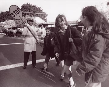
Document - Theobald, Augustus ‘Gus’
This file contains three items about Theobald, Augustus Gus. One page type-written document title CAULFIELD IDENTITIES on the history of Gus Thoebald. The summary of it is published in the nineteenth newsletter (April 1982) of Caulfield Historical Society. Original newspaper cutting from THE AGE dated 20/08/1990, a sports article remembering Augustus Gus Theobald at the V.A.A. mens cross-country championship held on 18/08/1990. He was killed in a road accident at 93. Two original black and white photographs of Gus Theobald as a school-crossing supervisor at O’Neil campus in Garden Vale, undated.caulfield, glen huntly, theobald gus, theobald augustus albert, glen huntly road, royal avenua, electrical business, glen huntly athletic club, medals, sport, sports people, school crossing supervisor, death and dying, castella nick de, ryan gerard, lubofsky jon, deveson glen, hoyle adam, theobald augustus gus, ramadge col. -
Glen Eira Historical Society
Document - Banks in Caulfield
This file contains two items. 1. A hand written list of branches of the English, Scottish and Australian Bank Limited and its merger the Australia and New Zealand Banking Group Limited, undated and author unknown. The list records the opening dates of branches in Carnegie, Caulfield East, Caulfield South, Elsternwick, Glen Huntly, Murrumbeena, Ormond, Garden Vale, Caulfield and Caulfield West encompassing years from 1886 to 1927, listing also the merger of the two banks as being in 1970 as well as 1852 as being the founding year of the English, Scottish, and Australian Bank Limited. 2. Three identical Elsternwick State Savings Bank withdrawal slips, from the 1910s. All three are blank, and include brief directions for filling in the slip typed at the bottom. Also included on the slip is a decorative illustration.banks, banks mergers, bank deposits, bank withdrawals, documents, banking, pass books, business and finance, annual reports, bank equipment, commercial equipment, bank branches, carnegie, carnegie koornang road 86, caulfield east, caulfield east derby road 9, caulfield south, caulfield south glen huntly road 790, elsternwick, elsternwick glen huntly road 324, elsternwick glen huntly road 426, glen huntly, glen huntly glen huntly road 1173, murrumbeena, murrumbeena murrumbeena road 59, ormond, ormond north road, ormond north road 553, garden vale, caulfield, caulfield west, caulfield hawthorn road 242, commercial establishments, the state savings bank of victoria, the state savings bank of victoria elsternwick branch, the english scottish and australian bank limited, the australian and new zealand bank limited, the australian and new zealand banking group limited -
 Glen Eira Historical Society
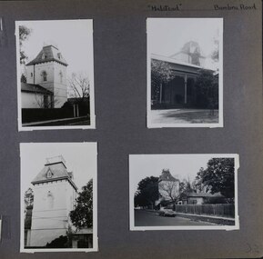
Album - Album page, Halstead, Bambra Road, Circa 1972
This photograph is part of the Caulfield Historical Album 1972. This album was created in approximately 1972 as part of a project by the Caulfield Historical Society to assist in identifying buildings worthy of preservation. The album is related to a Survey the Caulfield Historical Society developed in collaboration with the National Trust of Australia (Victoria) and Caulfield City Council to identify historic buildings within the City of Caulfield that warranted the protection of a National Trust Classification. Principal photographer thought to be Trevor Hart, member of Caulfield Historical Society. Most photographs were taken between 1966-1972 with a small number of photographs being older and from unknown sources. All photographs are black and white except where stated, with 386 photographs over 198 pages.From the Victorian Heritage Register Database - Citation for Halstead, 23 Bambra Road as at (as at 12/10/2020) https://vhd.heritagecouncil.vic.gov.au/places/276 Halstead is believed to be the oldest standing residence in Caulfield constructed in 1857 with subsequent additions during the 19th Century. The house was built for and owned by James Dickson, a stock agent, until his death in 1880. Although on a much reduced parcel of land, Halstead is one of the few remaining remnants of Caulfield when it was an area of mansion houses occupied by town residing squatters, professional and business men. It is important for its place in the socio-economic history of south eastern suburban Melbourne, the inland pattern of development stretching from Malvern through Murrumbeena. Architecturally the single storey building displays a history of alteration and addition. Its main front presents with a single storey cast iron verandah across the full width, including the two pavilion wings at each end. Located towards the rear on the Halstead Street side is the substantial three storey tower with its Mansard roof and cast-iron balustrade which makes the house clearly visible from Halstead Street and Bambra Road. Because of internal alteration the importance of the building relates to the exterior only of the main house. Halstead is believed to be the oldest standing residence in the city of Caulfield. https://vhd.heritagecouncil.vic.gov.au/places/43645 "Halstead" is regionally important as a surviving large villa from the early Victorian (1850's) period, offering insights into the lifestyles of the privileged in Caulfield at that time. The later tower is of architectural interest for its use of Medieval Romanesque enrichment.Page 32 of Photograph Album with four photographs of the exterior of this double storey house, focussing on different angles for the house's tower.Hand written: "Halstead" Bambra Road [top right] / 32 [bottom right] trevor hart, caulfield north, bambra road, 1850's, halstead, james dickson, mansion, villa residence, cast iron verandah, pavillion wings, halstead street, victorian, tower, balustrading, decorative brackets, mansard roof, brick, cast iron, slate roof, curved windows, single storey mansions, streetscapes, medieval romanesque style, slate roofs, gardens, cast iron work