Showing 171850 items matching "will street"
-
 Ballarat Tramway Museum
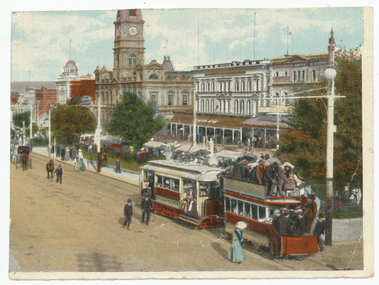
Photograph - Illustration/s, Ballarat Sturt St and crowded trailer
Colour illustration of eastbound Sturt Street tram with Town Hall in the background. ESCo tram towing former horse tram - Taken c1905 as tram does not appear to have a destination box fitted. Wal Jack has provided notes on the rear of the copy sent to Ken Magor, identifying the electric tram as No. 2 and the horse trailer as No. 4, the latter of which can be seen in the image. For a list and description of the same base image see Archives file - "Notes on ESCo Tram towing a heavily loaded trailer".Yields information about the ESCo electric trams towing former horse trams, passenger loading, colours schemes through the use of hand coloured and printed images.Colour illustration printed on plain paper and cut from a magazine or publication. Two copies held.On 2nd copy in pencil "Electric Supply Co of Victoria Ltd, Ballarat Tramways. No. 2 tram hauling No. 4 trailer, ex No 4 horse tram from Gardens in Sturt Street (from Doveton St), about 1912.trams, tramways, sturt st, horse trams, town hall, esco, tram 2, tram 4 -
 Kew Historical Society Inc
Financial record - Signature Book of the Kew Branch of the National Bank of Australasia
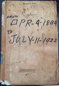
The National Bank of Australasia was formed in 1857. It began commercial operations in Queen Street, Melbourne in 1858. The Bank’s first branch in Kew opened at 87 High Street in 1885. A second building, on the corner of Walpole and Brougham Streets, designed by Inskip & Robertson, replaced the first branch in 1888. The second building remains, albeit in a somewhat altered state. In 1977, the President of the Kew Historical Society received two historic ‘Signature Books’ from the Kew branch of the National Bank of Australia.Important and unique record of names, occupations, addresses and signatures of customers of the branch. A number of signatures belong to individuals of statewide significance. Other information such as customer occupations may be unique.Ledger containing information about customers of the National Bank of Australasia's Kew Branch for the years 1894-1922. The ledger (N9457) was purchased on 9/12/85 from Sands & McDougall, Manufacturing Stationers, 46&48 Collins Street West, Melbourne. The front pages of the ledger have lines and lists of names and customer numbers. Subsequent sections are organised alphabetically by customer name. Columns on these pages include data arranged by: No. | Date | Name and Description (to be clearly written off by a member of the bank) | Signature | Initials of Bank Officer. On each page, sequential numbering extends across the years 1894-1922. Additional pieces of advice from customers are clipped through the page over the customer's signature. Spine - "SIGNATURE BOOK / N.B.OF A." Inside front cover: Stationers labelnational bank of australasia -- kew (vic.), signature books, banks -- kew (vic.), gordon greer, mr bendixon, marshall slattery, manuscripts, financial records, bank records, national bank of australia -
 Federation University Historical Collection
Photograph, Installation of university of Ballarat Chancellor David Caro, 28/10/1998
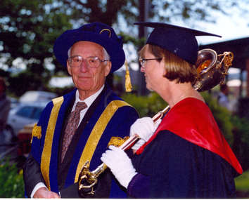
The Installation of the Chancellor Professor Emeritus David Edmund Caro, AO, OBE as the second University of Ballarat Chancellor took place on 28 October 1998 at the Lydiard Street Uniting Church, corner of Lydiard and Dana Streets, Ballarat.Nine colour photographic prints taken at the installation of the second University of Ballarat Chancellor, Professor Emeritus David Caro, AO, OBE. .1) Governor Sir James Gobbo greets David Caro .2) Father Rupert O'Down in blue hood .3) Michael Ronaldson in suit, Mary Akers in grey hood behind man in red. Gabrielle McMullan in blue and pink gown (left) .5) Vice Chancellor David James (left) speaks to Governor Sir James Gobbo .6) Academic Procession in Lydiard Street, Ballarat .7) University of Ballarat Mace followed by David Caro and Sir James Gobbo. (Bill Pryor on far right) .8) Chancellor David Caro and Mace holder .9 Janet Dawe stands with Bagpipe players outside the Ballarat Club. caro, david caro, gobbo, james gobbo, governor of victoria, chancellor, university of ballarat, william pryor, michael ronaldson, gabrielle mcmullin -
 Ringwood and District Historical Society
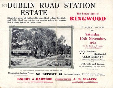
Pamphlet, Land Sale Brochure, Dublin Road Station Estate - 1923
"Extracts from Recent Daily Newspaper - Ringwood Train Service - STATION WANTED AT RINGWOOD EAST. A deputation from the Ringwood East Railway League and Progress Association waited on the chairman of the Railway Commissioners yesterday afternoon and asked that a railway station be erected at Dublin-road, a mile and a quarter from Ringwood. The deputation urged that there were 81 passengers who, if the station were provided, would make daily use of it, and that as the Commissioners had purchased a site for a station at Dublin-road it was evident they had at one time considered it the most suitable site. The Chairman of Commissioners stated that the estimated cost of the station was £3700. Land owners in the locality should pay a proportion of the cost. Members of the deputation replied that there would be no difficulty in raising the money."Multi-fold brochure advertising public auction of residential allotments on Saturday, 10th November, 1923. Brochure includes subdivision features, local facilities and photographic images of the area and details of proposed new railway station at Dublin Road.Subdivision plan includes Dublin Road, Alexandra Road, Vonadawn Avenue, Green Street, Howard Avenue, Wood Street, and Bedford Road (Main Ferntree Gully Road). Auctioneer - Knight & Harwood, 315 Collins Street, Melbourne, Phones Central 10615, 10616. Agent - J.B. McAlpin, Opposite Railway Station, Ringwood, Phone Ringwood 7. -
 Ringwood and District Historical Society
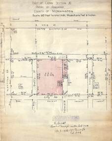
Document, 1926 Land Survey drawing of the area surrounding 1-5 City Road, Ringwood
Drawing on parchmentHand-drawn survey of what is now 1-5 City Road, Ringwood. Drawn by K Arndt, licensed surveyor, 237 Queen Street, Melbourne Tel 5118 on 25 September 1926. The block of land in question was 2 roods, 21 and 8/10 perches in size. The location was between Haig Street in the north, City Road in the south, Wantirna Road in the west and Victoria Road in the east. The Good Shepherd Retirement Village (Lutheran) now occupies the land. The drawing shows a number of existing weatherboard houses, fences and frontage sizes. A number of named roads were defined but no longer exist, these were Duffy Street (to the west), Evans Street (east) and Victoria Street (further east). Ireland Street still exists in the south. -
 Kew Historical Society Inc
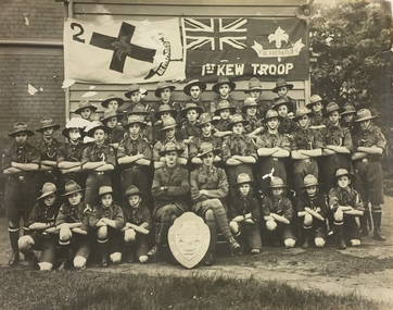
Photograph, 1st Kew Scout Troop with the Cohen Shield, c.1922
The 1st Kew Scouts was one of the first Scout Troops in Victoria, being formed in 1909. From 1927 they met in a magnificent Scout Hall in Disraeli Street, Kew until it was demolished in 1993. Still operating (in 2020) from their new Scout Hall on the corner of Kilby Road and Kellett Grove, Kew.Large group photo, mounted on card, of 1st Kew Scouts in uniform. The group of thirty-seven Scouts and two leaders (probably R.J. Poewrie SM and R. Wall ASM) are posed with a shield, likely to be the ‘Cohen Shield’, awarded at a statewide Scoutcraft competition for ‘Champion Troop of Victoria’. This was won by 1st Kew in 1922. The building in the photo is not the Disraeli Street Hall, which was a weatherboard construction.1st Kew Troop cohen shield, 1st kew scout troop, kew - scouts -
 Bendigo Historical Society Inc.
Photograph - T C WATTS & SON COLLECTION: 158 WILLIAMSON STREET, BENDIGO, 1930
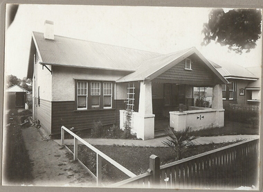
Thompson Roy Morrison (1900-1972) was born in Bendigo and married Ivy Maria Knight in 1924. They lived at 63 Williamson Street. Ivy died aged 31 in 1933. Thompson remarried Violet Jean Hesse in 1936 but she died in 1938 also aged 31. Thompson was a motor painter.Black and white photograph mounted on rectangular grey board. House, weatherboard and rough cast, corrugated iron roof, porch with roughcast balustrade and pillars, 1 chimney, picket fence with capping board, garage at back on left hand side. Scalloped pattern on front gable with vent. On back of photo: Morrison, Williamson Street, sewered £1450'. 2012 photo of house attached to record.Frank A. Jeffree, Bendigo?bendigo, business, t c watts and son, stamped on back ''t.c. watts and son'' stamped on back in circle ''royal historical society of victoria, bendigo branch'' -
 Warrnambool and District Historical Society Inc.
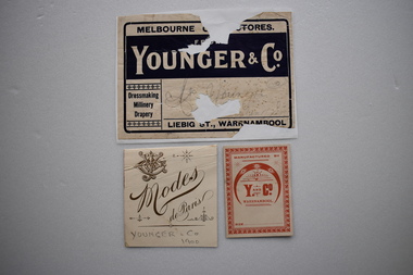
3x Labels, Gaspars Modern Printing Co, Younger & Co, Early 20th century
Originally known as the Melbourne Cash Stores the general merchandise business of Younger and Co. was a dominant one in Liebig Street, Warrnambool from 1888 with the arrival in town of John Younger through to the store closure in 1983. John Younger was the director of the Warrnambool Woollen Mills in1903, the Mayor of Warrnambool in 1910 serving two terms and an elder of the Presbyterian Church. These labels are of importance as the John Younger store was a prominent business in Warrnambool for over ninety years..1 Rectangular cream and dark blue label with text. It is adhered to a piece of white paper. The label is damaged so that some of the text is obliterated. . .2 Rectangular thin card cream label with red text and a decorative border. .3 Cream rectangular label with a symbol of a Y and CO intertwined, other small decorations and text all in gold colour..1 MELBOURNE ( OBLITERATED) STORES FROM YOUNGER & CO. Dressmaking Millinery Drapery LIEBIG ST., WARRNAMBOOL.( In pencil and handwritten) Mrs. J Younger Darling Street .2 MANUFACTURED BY Y AND CO. WARRNAMBOOL SIZE.... .3 Modes de Paris YOUNGER & CO. 1900 ( in pencil ) ..younger and company, warrnambool -
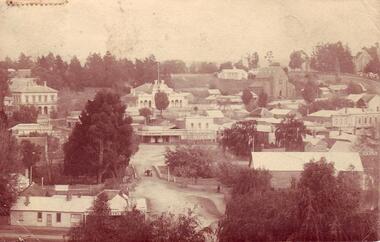 Clunes Museum
Photograph
PHOTOGRAPH OF CLUNES TAKEN FROM CLUNES SCHOOL HILL 1905. LOOKING WEST, PRESBYTERIAN CHURCH (ST.ANDREWS) METHODIST (WESLEY) Etc..1.2 TWO SEPIA POSTCARD PHOTOGRAPHS OF CLUNES TAKEN FROM THE SCHOOL HILL. - POST OFFICE, TOWN HALL, ST. THOMAS AQUINAS, ST PAUL'S CHURCH, FRASER STREET SHOPS, ALBION HOUSE, CLUB HOTEL, BUTTER FACTORY BRIDGE AND BUTTER FACTORY, LION HOTEL. .3 PHOTOCOPY BLACK AND WHITE OF THE POSTCARDS.1 Addressed to Miss. L. Weickhard C/o Lucas's Cafe Collins Street Melbourne. One penny stamp affixed, postmarked 05 Message: Dear Miss Wieckhard, Many thanks for the post cards you sent me. This is one to add to your collection, With Kind regards From Florrie B .2 Addressed to Mrs. L. McLennan Olive Marlborough Rockhampton Queensland Message With best wishes for a happy New Year E.M.S.photography, town hall, post office, weickhardt -
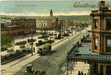 Ballarat Tramway Museum
Postcard, WTP, ESCo tram near the intersection of Doveton St. and Sturt St, 1905
Photo appears to be taken soon after opening of the electric trams, as the tramway is well paved compared to the rest of the street which shows vehicle tracks etc. Small horse drawn vehicle crossing in front of the photograph. Shows buildings along the north side of Sturt St. and the building at the SE corner of Doveton St. ESCo tram has destination board on the front dash of the tram.Yields information about the appearance of Sturt St soon after the opening of the electric tram service in Ballarat.Printed colour postcard of an ESCo tram near the intersection of Doveton St. and Sturt St. travelling west along the south side of Sturt Street. Titled "Sturt Street, Ballarat" in the top left-hand corner and overprinted, embossed in gold, with the words "Christmas Greetings". On the rear of the postcard is a letter to Miss Hancock, Pitt St. Rockdale NSW, from a W.H. Nicholls. Message in pencil, address in ink. Postcard made by "WTP" Has a "Victoria One Penny" stamp. Does not appear to have been cancelled. Assumed used in 1905. On the rear of the second copy is a note to Miss Gibbs of Mole Creek Tasmania, dated 22/12/1907, sent from South Melbourne. See Reg. Item 834 for a scanned copy of another version of this postcard.Handwritten letter on card.trams, tramways, esco, sturt st, postcards, doveton st -
 Bendigo Historical Society Inc.
Photograph - Cnr Mundy & Mollison Streets, Bendigo
This site was originally that of Cobb and Co's livery stable and although the Cobb and Co office in the Shamrock Hotel closed in 1886, the livery stable continued with the proprietors, Robertson and Wagner and Co. The site was bought in August 1898 by the Fresh Food and Frozen Storage Co, proprietors of the Bendigo Butter Factory. On this site the company built an ice tory, refrigerating works and cool storage for other businesses. The Bendigo Butter Factory was begun in 1894 in Lucan Street, opposite the distillery, by Mr McIntyre of the Rochester district. This site included a butter printer and Weigher supplied by Cherry and Son of Gisborne. In September 1895 the Butter factory was floated as a public company and was registered by Mr J H Curnow. However the factory was not financially sound at this point and entered into receivership in 1896. At this time it was bought by the Fresh Food and Frozen Storage Company of Melbourne and was placed under the management of James Cumming, an experienced dairyman. The company had previously appointed him as their inspector of creameries. By 1911 he was the propietor of the Flora Hill Butter Factory. and was later killed in a car accident in May 1937. By 1919 the manager was Douglas Orson Oldfield (1868-1944) (NB at birth he was registered as Dugald and throughout his life he was also known as Dan).Colour photograph. Building on the corner of Mundy & Mollison Streets, Bendigo (opposite the former Gravel Hill State School). Building was formerly Charlton's Cobb & Co. building, and latter Bendigo Butter factory.cnr mundy & mollison streets, charlton's cobb, bendigo butter factory -
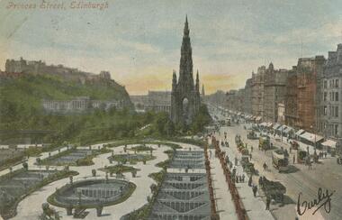 Bendigo Historical Society Inc.
Postcard - GLADYS DEAN COLLECTION: POSTCARD, 1906 - 1908
Printed coloured photographic postcard. Image depicts a formal garden in the foreground with a wide street to the right hand side. Buildings line the street into the distance with a large Gothic building in the middle. A castle is in the background high on a hill. Street traffic of trams and horse drawn vehicles can be seen, with people walking and standing on the footpaths. The words Princes Street Edinburgh are printed in red along the top left hand corner. A signature has been written across the lower right hand corner. Reverse is addressed to Miss Dean Esmond Golden Square with a one penny stamp postmarked Bendigo.Valentines Seriespostcard -
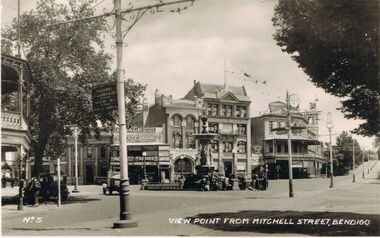 Bendigo Historical Society Inc.
Photograph - LESLIE JOHN BAGUST COLLECTION: VALENTINE BENDIGO POSTCARDS, 1940
Leslie John Bagust Collection. Black & White Photograph View Point Bendigo From Mitchell Street Streetscape. Souvenir Postcard Collection ?Rose Series. 1940. Scene looking North up View Street Lucas Café, on the corner, Alexandra Fountain in the centre, Newsagent opposite fountain. To the right of the newsagent heading north the Australian Mutual Provident Society and Davies Store are prominent features. Underneath Davies Store signs advertising Macrow Better Furniture Stores. Observe the tram line runs the length of Mitchell Street all the way up View Street.Valentine Publishing Co. Pty Ltd. Melbournebendigo, tourism, view point from mitchell street -
 Kew Historical Society Inc
Photograph - Former Kew Town Hall, Walpole Street, 1970
The Municipality of Kew was granted independence in 1860. It was declared a borough in 1863, a town in 1910 and a city in 1921. In 1994, Kew was amalgamated into the new City of Boroondara.Black and white photographic positive of the front of the (former) Kew Town Hall in Walpole Street between High Street and Malmsbury Street, on the west side where Woolworth's supermarket now stands. The photograph, from August 1970 shows the detailing of the Italianate rendered-brick facade, added in the 1880s when the hall was renovated. The earliest building on the site was the Kew Athenaeum Hall (built 1860) which was purchased by Kew Council in 1865. The Town Hall was sold to Woolworth's and subsequently demolished in 1972 when the civic offices were transferred to a new building on the corner of Charles Street and Cotham Road."Old Kew Town Hall / Walpole St / Aug 1970/ Gift of Stewart West 1990"kew town hall -- walpole street, local government -- kew, civic buildings -- kew (vic.), town halls -- melbourne (vic.) -
 Wodonga & District Historical Society Inc
Photograph - Mann Collection Album - Old Police Station and Courthouse, C1964
Elaine Mann was married to David Mann, a successful Wodonga businessman and community leader who passed away in Wodonga in June 2012. David was a member of the Mann family who began their business in Wodonga in 1920. Elaine was a teacher in Wodonga for many years and an active member of the community.This photo collection is of significance as it documents how the businesses and buildings in Wodonga have evolved and contributed to community throughout the late 20th century.This was Wodonga's second police station, built in 1900. It was built on High Street, next to Bond Street. The Court House can be seen in the background. The building was formerly used as a custom-house or bond store where people paid import duties on goods coming into Victoria from other states, including N.S.W. This is reflected in the street name. The Court House was destroyed by fire in 1964. This police station was in use until a move was made into a new police station in Elgin Street (next to Elgins Hotel) in December 1967. This area is now part of the newly developed Junction Place Precinct.high st wodonga, woldonga police station, wodonga court house, bond store -
 Ringwood and District Historical Society
Document - Subdivision Map, Part of Crown Portion 22 Parish of Ringwood, County of Mornington. Vol 1915 Fol 827 - LP2427
LANDATA Land Victoria 4-sheet plan dated January 2003 - copy of original 1889 subdivision, amended with 1947 amendments by Assistant Registrar of Titles.Sheet 1 includes Main Lilydale Road (later Old Lilydale Road), Wandin Road (later Mount Dandenong Road), and Joseph Street, Ringwood East. Additional Plan markings SP30844, SP32804, LP144251, PS332061, PS305232. Sheet 2 includes Main Lilydale Road (later Old Lilydale Road), Wandin Road (later Mount Dandenong Road), and Dynes Street, Ringwood East. Additional Plan markings LP43708, LP44231, LP124702. Sheet 3 includes Main Lilydale Road (later Old Lilydale Road), Dynes Street, Albert Street (later Wyrunga Street), and Carcoola Road, Ringwood East. Additional Plan markings LP114181, LP114180, LP18261, LP214030, LP67300, PS354509, PS335500. Sheet 4 includes Main Lilydale Road (later Old Lilydale Road), Albert Street (later Wyrunga Street), and Carcoola Road, Ringwood East. Additional Plan markings PS315494, PS319495. -
 Kew Historical Society Inc
Plan, Melbourne & Metropolitan Board of Works : Borough of Kew : Detail Plan No.1574, 1905
The Melbourne and Metropolitan Board of Works (MMBW) plans were produced from the 1890s to the 1950s. They were crucial to the design and development of Melbourne's sewerage and drainage system. The plans, at a scale of 40 feet to 1 inch (1:480), provide a detailed historical record of Melbourne streetscapes and environmental features. Each plan covers one or two street blocks (roughly six streets), showing details of buildings, including garden layouts and ownership boundaries, and features such as laneways, drains, bridges, parks, municipal boundaries and other prominent landmarks as they existed at the time each plan was produced. (Source: State Library of Victoria)This plan forms part of a large group of MMBW plans and maps that was donated to the Society by the Mr Poulter, City Engineer of the City of Kew in 1989. Within this collection, thirty-five hand-coloured plans, backed with linen, are of statewide significance as they include annotations that provide details of construction materials used in buildings in the first decade of the 20th century as well as additional information about land ownership and usage. The copies in the Public Record Office Victoria and the State Library of Victoria are monochrome versions which do not denote building materials so that the maps in this collection are invaluable and unique tools for researchers and heritage consultants. A number of the plans are not held in the collection of the State Library of Victoria so they have the additional attribute of rarity.Original survey plan, issued by the MMBW to a contractor with responsibility for constructing sewers in the area identified on the plan within the Borough of Kew. The plan was at some stage hand-coloured, possibly by the contractor, but more likely by officers working in the Engineering Department of the Borough and later Town, then City of Kew. The hand-coloured sections of buildings on the plan were used to denote masonry or brick constructions (pink), weatherboard constructions (yellow), and public buildings (grey). This plan shows several very large houses, particularly along Glenferrie Road, and the area now occupied by Ruyton Girls’ School. ‘Tarring’ (incorrectly spelled here as ‘Karring’) was built for Henry Henty in 1872, on part of his original allotment of 20 acres, and ‘Mount View’, which retains its original building and the fountain in the front garden, is part of Ruyton’s Junior School. The most significant change to Tarring and its grounds since 1903, involve the removal of a number of the outbuildings, including a Burmese temple, bought by Henty from the Burmese Exhibit at the Great Exhibition of 1880. It is shown on the plan as a summerhouse. The two-storey mansion, on the corner of Glenferrie Road and Wellington Street, was built in 1891 by leading architect Alfred White as his own home. Having an initial N.A.V. of £160, the house was purchased by a warehouseman Henry Lister, by 1900, when the N.A.V. was recorded at £111. By the turn of the century the house was known as ‘Comaques’. By contrast, much smaller houses are shown in Scott and Byron Streets, including a tiny Mission Hall in Byron Street, which belonged to the Anglican Church from at least 1903 to 1917.melbourne and metropolitan board of works, detail plans, maps - borough of kew, mmbw 1574, cartography -
 Charlton Golden Grains Museum Inc
Photograph, 1923 Flood - Telegraph Hotel, Armstrong Street Charlton, c. 1923
1923 Flood, Telegraph Hotel, Armstrong Street, Charlton, Victoria1923 flood - Telegraph Hotel, Armstrong Street Charlton. Obituary: Charlton 100 years ago 18-02-1922 - 24/02/1922. Mr Francis Gilbert Livingstone passed away at Castlemaine on 14th ins. He was a very well known & highly respected old resident of Charlton & Narrewillock. Until October last he held the license of the Telegraph Hotel and was a familiar figure in his wheel chair under the shade trees at land at Narrewillock, where he farmed until failing health compelled him to give up the strenuous work of those early pioneering days, and in 1892 he took the license of the Telegraph Hotel which he retained until recently. He was 61 years of age.flood, telegragh hotel, charlton, livingstone -
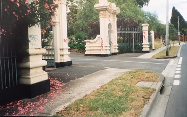 Kew Historical Society Inc
Photograph - Gates, Victoria Park, 1988
The Kew Asylum Entrance Gateway and an adjacent gate lodge were built at the Princess Street entrance in 1873.1 The imposing sandstone pillars and cast-iron gates impressed upon visitors the therapeutic and civilising vision of the asylum. The entrance opened onto a tree-lined drive (now known as Main Drive) which culminated in an elliptical carriageway in front of the main building. (Heritage Council of Victoria)Colour photographic positive of the former Kew Asylum Gates which were relocated in 1942 to Victoria Park in High Street, Kew. The gates were listed by Heritage Victoria in 2020. The citation reads: "The Former Kew Asylum Entrance Gateway consists of two 4.5 metre sandstone gate piers on bluestone bases on either side of a 5.5 metre vehicle entrance set back from the High Street pavement. The 1870s gate piers are of Barrabool sandstone and repairs during 2015-16 were undertaken with sandstone from English Town, Tasmania. The gate piers are highly decorative and feature oculi, triglyphs, dentils, corbeling and other ornamental work. Each gate pier incorporates a pedestrian archway with a cast-iron pedestrian swing gate. Two curved sections of cast-iron palisade fencing on rusticated bluestone blocks extend from the outer edges of the piers to a set of shorter sandstone pillars on the High Street pavement. Straight sections of cast-iron fence extend 4.5 metres ending at two bluestone pillars. Garden beds have been created within the curved sections of fencing, bordered by concreted bluestone and planted with shrubs." (Heritage Council of Victoria)gates -- kew asylum, gates -- victoria park -- kew (vic.) -
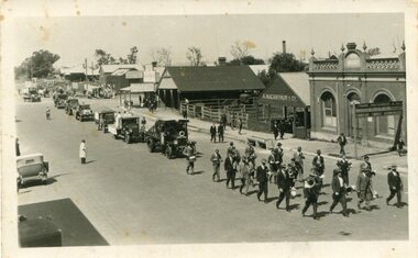 Orbost & District Historical Society
black and white photograph, 1925 - 1930
The photograph shows Bairnsdale carnival procession which the Orbost Band led as there was no Bairnsdale group. The first Orbost Brass Band was formed in 1889. Around 1908 the town band split and the Orbost Workers' Band was formed. Eventually the two bands merged in 1913 to reform as the Orbost Municipal Band under conductorship of Charles Spink. The band continued for many years but was later disbanded and again reformed. This was to happen a number of times, the last time being in 1961 and continuing through to the late 1970's. Further info and Ref: In Times Gone By - Deborah Hall This is a pictorial record of the Orbost Brass Band. The various Orbost bands over the years played a major role in community activities providing entertainment and musical experiences for the many members.A black / white photograph showing a procession through a main street. There is a band in the lead followed by several motor vehicles and a horse drawn vehicle. In the background is Bairnsdale Farm and Dairy Produce Market - The Mart - Mr C. A. Drevermann, A. Macarthur & Co. in Macmillan Street.on back - "Bairnsdale Band was defunct and Orbost Band played at the Bairnsdale carnival - includes Eric Wehner - Mrs O. Wehner"orbost-band orbost-municipal-band orbost-brass-band -
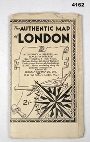 Bendigo Military Museum
Map - MAP of LONDON, The Authentic Map of London
Map of London with also places of interest. Part of th collection of Frederick Gardner Davey DFC No 410533 RAAF. Refer cCat No 3536P for his service details.Black and white folded street map with transport routes/stations marked in orange. Cover is black and white print, features a scroll and compass design inside a B & W border, written details in black type, street index printed on inside of the cover.map, london -
 Ringwood and District Historical Society
Photographs, Smith, Richard, Ringwood Molan/Madden Streets locality in 2000, 2000
Photos (25) in Agfa folder. Location Ringwood Molan/Madden Streets locality in 2000. They show Nissen huts in Madden Street behind the old Coach and Horses Hotel,and other properties in the eventual path of the Eastern Freeway. +Additional Keywords: Smith, Richard -
 Federation University Historical Collection
Notebook, Alex Ball, Notes of Lessons, 1964
Alex Ball attended the Ballarat Teachers' College This notebook contains details regarding Alex Ball's teaching rounds at the following schools around Ballarat. They were the Wendouree state school, Wendouree west state school, Pleasant street state school, Macarthur street rural school, and Alfredton state school.Included throughout the notebook are various handwritten images which were noted as a copy of that day's lesson taken off the blackboard.They were kept in place with metal holders. The registration no. "11733" is included on the front page in pencil.alex ball, lesson plan, notebook, wendouree state school, wendouree west state school, pleasant street state school, macarthur street rural school, alfredton state school -
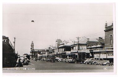 Bendigo Historical Society Inc.
Postcard - HARGREAVES STREET BENDIGO
Postcard, black and white: On image ' Hargreaves Street, Bendigo' V. 38.' bottom LH side. Image shows shop fronts on either side of street, cars parked on kerb. Verandahs intact on shops. W.H. Ray, Baker & Woods names visible.Valentine'sbendigo, streetscape, hargreaves street, bendigo, hargreaves street. baker & woods, w.h. ray -
 Bendigo Historical Society Inc.
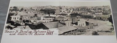
Photograph - QC Binks collection: Rowan Street
BHS CollectionBlack and white copy of a photograph showing Rowan Street, Bendigo between View and Wattle Streets. Approx. 1880. Some of the names on buildings include, Rifle Brigade Hotel, J. Power wine & spirit store and Hodgson Bros. painter and paper hanger.C. 1873 in pencilbendigo, 1880, rowan street -
 Bendigo Historical Society Inc.
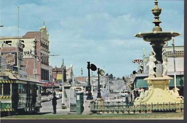
Postcard - ALEXANDRA FOUNTAIN LOOKING SOUTH TO MITCHELL STREET
Colour Postcard: Mitchell Street from Charing Cross. Alexandra Fountain on RH side, tram on LH side. Cars parked and on Mitchell Street. Plaza Theatre sign visible. On back: Nu color Vue, Bendigo, Victoria. BE 24 1950's ?bendigo, streetscape, charing cross, bendigo, mitchell street, alexandra fountain, tram -
Port Melbourne Historical & Preservation Society
Photograph - Demolition, various establishments on Port Melbourne foreshore, Ron Laing, 1986 - 1999
Part of Ron Laing's collection of photographs taken around Port Melbourne over a thirteen year period. Donated to the PMH&PS by the photographer.One of 104 colour photographs covering the demolition of all the establishments on the foreshore between Beacon Road and Princes Street (i.e. 'Bayside' site): BP, Engine Works, PMG (Telecom), Seamen's Mission, Centenary Bridge and Princes Street flats, from 1986missions to seamen, industry, manufacturing, centenary bridge, built environment - industrial, demolitions, ron laing, british petroleum oil co, commonwealth engine works, telecom -
Port Melbourne Historical & Preservation Society
Photograph - Morley's Coal Depot, Bay Street, Port Melbourne, Arthur Rowan, 1986
As a member of the Port Melbourne Historical and Preservation Society, donor Arthur ROWAN photographed a series of significant buildings in the Port and South Melbourne area over several years. A selection of nineteen of these was presented to the Port Melbourne Society in 1993.Small print mounted on white card, with mounted, typed caption: Morely's Coal Depot 2 Bay Street, corner Beach Street and Post Office Place. Established 1872. First owner: William T. CLARKE [Photo from north east]built environment - commercial, arthur rowan, william t clarke, morley coal depot, william morley -
 Port Melbourne Historical & Preservation Society
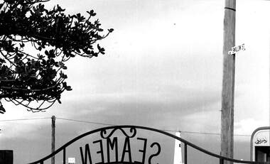
Photograph - From inside the gates to Missions to Seamen, Port Melbourne, Alison Kelly, 1990
Photographed by Alison Kelly while she was joint caretaker of the building during the Mission Arts Centre days 1987 to 1991Missions to Seamen, black and white detail of iron gate from Mission grounds; view to southwest showing Swallow Street sign, outer beacon, edge of Beach Street bus stop and distant Willamstown. From album of photos mostly by Alison Kellymissions to seamen, built environment, beacons -
 Bendigo Historical Society Inc.
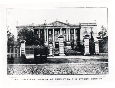
Photograph - HARRY BIGGS COLLECTION: BENEVOLENT ASYLUM BENDIGO
Photograph. Harry Biggs Collection. Photo of the Benevolent Asylum as seen from the street, Bendigo. Large ornate building with tall pillars at the front. There is a man standing in the foreground. Plate 20 The Benevolent Asylum as seen from the street, Bendigo (printed under the picture).Robinson Photoplace, building, public buildings, harry biggs collection, the benevolent asylum, bendigo