Showing 119 items matching historic buildings register
-
 The Beechworth Burke Museum
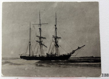
Photograph, 1907-8
... on the Victorian Registers of historic buildings. Interestingly, the name... on the Victorian Registers of historic buildings. Interestingly, the name ...The photo from 1907-8 is a sepia print, depicting a small valley with building at base. There are flumes visible above areas of water, trees on hills and a few small cottages on the hillside. Cock's Pioneer Gold & Tin Sluicing Co NZ No 2 Site. The photo was taken of Matthews Gully looking west. Sluicing was undertaken in the area from 1900 to 1942 with some short breaks between these periods. The image depicts a location mined by Cocks Pioneer Gold and Tin Sluicing Company (as recorded on the annotation on the card mount) The Cocks Pioneer Gold and Tin Mines N.L was one of El Dorado's two largest open cut sluicing mines of the 20th Century. The other was named the Cocks El Dorado Gold Dredging Company. The Cocks Pioneer Mines operated from 1901 until 1941 and found a total of 117,378 ounces of Gold and 1,673 tones of tin concentrates over these years. The Cocks company was formed in 1898 and operated until 1941. Open cut sluicing involved the use of high-powered hoses which used the centrifugal sand pump system (known as hydraulic sluicing) which broke down the soil which was then processed for gold and other precious metals. From 1914 , four years after this image was captured, the company reformed to Cocks Pioneer Gold and Tin Mines NL (previously it was known as Cocks Pioneer Sluicing Co) and undertook large scale sluicing operations until 1929 and then 1934-1941. El Dorado is located on Reedy Creek and is surrounded by forested country to the north and east. It is 20 km east of Wangaratta in Victoria's regional north-east. John Cock was the son of a Cornish minor who arrived in El Dorado in 1858. Cock founded his gold and tin mining company which ran successfully for many years in the El Dorado region. It was an open cut sluicing company because of the abandonment of underground mining after this was deemed too dangerous. In 1935 Cock's El Dorado Company commissioned the floating dredge which is still visible in El Dorado today. The dredge was built by the Thompson engineering works, Castlemaine, and weighed over 2,000 tones and today has a place on the Victorian Registers of historic buildings. Interestingly, the name El Dorado does not derive from the gold in the region, but from the Barambogie pastoral run completed by William Baker in 1840-1841. Gold was discovered in El Dorado 1854 but the gold was too deep for individual prospectors to find, it required the use of heavy machinery.The search for gold is ingrained into the history of Victoria and therefore, images like this one which portray an open cut sluicing site can reveal important information for society and technology for the date when the photograph was taken. This image is of important historical significance for its ability to convey information about sluicing and the methods used to find gold in 1910. It also shows a location where sluicing was undertook which provides insight into the impact of sluicing on the environment at a time when it was done. This image is important for current research into the history of El Dorado, a small regional location near Wangaratta in Victoria's North East. Therefore, this image has the capacity to be beneficial for research into society and the motivations of those living and working in this region during this period and therefore, has social significance. The Beechworth Burke Museum has additional images relating to gold sluicing and El Dorado which can be analysed and studied alongside images like this one.Sepia coloured rectangle photograph printed on gloss photographic paper Reverse: 1997. 2613/ A02613/ No2 site/ Matthews Gully/ Cocks Pioneer G&T. ?? Co NZ/ No2 Site looking West/ 1907-8/ (7)sluicing, hydraulic sluicing, 1907, 1908, mining, cock's pioneer gold & tin sluicing co nz, nz, site no 2, matthews gully, west, valley, building, cottages, hillside, trees, water, gold and tin mine -
 The Beechworth Burke Museum
Photograph, 1910 - 1911
... on the Victorian Registers of historic buildings. Interestingly, the name... on the Victorian Registers of historic buildings. Interestingly, the name ...This photograph depicts Cock's Pioneer G & T Sluicing site No. 4 in El Dorado. Looking eastwards, the photo captures a wooden and tin building with various mining equipment strewn in the foreground. Underneath the verandah, figures can be seen. These are believed to be a Mr. Hollister (left), Mrs. Breustedt (4th from left), children Min and Chris Breustedt, and Kate Timmons holding a girl's hand. The Cocks Pioneer Gold and Tin Mines N.L was one of El Dorado's two largest open-cut sluicing mines of the 20th Century. The other was named the Cocks El Dorado Gold Dredging Company. The Cocks Pioneer Mines operated from 1901 until 1941 and found a total of 117,378 ounces of Gold and 1,673 tones of tin concentrates over these years. The Cocks company was formed in 1898 and operated until 1941. Open cut sluicing involved the use of high-powered hoses which used the centrifugal sand pump system (known as hydraulic sluicing) which broke down the soil which was then processed for gold and other precious metals. From 1914, four years after this image was captured, the company reformed to Cocks Pioneer Gold and Tin Mines NL (previously it was known as Cocks Pioneer Sluicing Co) and undertook large-scale sluicing operations until 1929 and then 1934-1941. The Cocks Pioneer was an extremely successful mining company during the 20th century. In the Annual Report of the Secretary for Mines for the year 1915, the Cocks Pioneer was the largest producer of gold and tin collecting 5,535 ozs. of gold and £7,500 of tin. Twenty years later in 1935, Cocks Pioneer was still one of the most profitable mines in Victoria, ranking as the second-highest dividend paying mine. The company produced a total of 3,650 kg of gold. El Dorado is located on Reedy Creek and is surrounded by forested country to the north and east. It is 20 km east of Wangaratta in Victoria's regional northeast. John Cock was the son of a Cornish miner who arrived in El Dorado in 1858. Cock founded his gold and tin mining company which ran successfully for many years in the El Dorado region. It was an open-cut sluicing company because of the abandonment of underground mining after this was deemed too dangerous. In 1935 Cock's El Dorado Company commissioned the floating dredge which is still visible in El Dorado today. The dredge was built by the Thompson engineering works, Castlemaine, and weighed over 2,000 tones and today has a place on the Victorian Registers of historic buildings. Interestingly, the name El Dorado does not derive from the gold in the region, but from the Barambogie pastoral run completed by William Baker in 1840-1841. Gold was discovered in El Dorado in 1854 but the gold was too deep for individual prospectors to find, it required the use of heavy machinery.The search for gold is ingrained into the history of Victoria and therefore, images like this one which portray an open cut sluicing site can reveal important information for society and technology for the date when the photograph was taken. This image is of important historical significance for its ability to convey information about sluicing and the methods used to find gold in 1910. It also shows a location where sluicing was undertook which provides insight into the impact of sluicing on the environment at a time when it was done. This image is important for current research into the history of El Dorado, a small regional location near Wangaratta in Victoria's North East. Therefore, this image has the capacity to be beneficial for research into society and the motivations of those living and working in this region during this period and therefore, has social significance. The Beechworth Burke Museum has additional images relating to gold sluicing and El Dorado which can be analysed and studied alongside images like this one.A black and white copy of a sepia coloured rectangular photograph printed on matte photographic paper mounted on boardObverse: COCKS PIONEER G + T SL CO, N.L. / 1910 - 11 / NO 4 SITE LOOKING EAST / 4 Reverse: 1997.2508 / AUG 29 1909cocks pioneer gold and tin sluicing company, el dorado, mining, sluicing, hydraulic mining, hollister, breustedt, timmons, gold, tin, gold rush, victoria -
 The Beechworth Burke Museum
Photograph, 1910
... on the Victorian Registers of historic buildings. Interestingly, the name... on the Victorian Registers of historic buildings. Interestingly, the name ...This photograph dating to 1910 depicts an open cut sluicing site located in El Dorado captured looking east up the open cut from the number 3 Barge site. Sluicing was undertaken in the area from 1900 to 1942 with some short breaks between these periods. The image depicts a location mined by Cocks Pioneer Gold and Tin Sluicing Company (as recorded on the annotation on the card mount). It portrays open cut rocks with a crevice in the center of the image where the sluicing was being undertaken. There is a small timber structure on the right of the image which could be an entrance to a mine or supports made of wood to prevent a cave in at the open cut site and above the cut rock there is bush. The timber structure has rail tracks on top of the bridge which could suggest the identification of this structure as a mine entrance. The rail tracks were used for little carts which hauled soil from the mine. The Cocks Pioneer Gold and Tin Mines N.L was one of El Dorado's two largest open cut sluicing mines of the 20th Century. The other was named the Cocks El Dorado Gold Dredging Company. The Cocks Pioneer Mines operated from 1901 until 1941 and found a total of 117,378 ounces of Gold and 1,673 tones of tin concentrates over these years. The Cocks company was formed in 1898 and operated until 1941. Open cut sluicing involved the use of high-powered hoses which used the centrifugal sand pump system (known as hydraulic sluicing) which broke down the soil which was then processed for gold and other precious metals. From 1914 , four years after this image was captured, the company reformed to Cocks Pioneer Gold and Tin Mines NL (previously it was known as Cocks Pioneer Sluicing Co) and undertook large scale sluicing operations until 1929 and then 1934-1941. El Dorado is located on Reedy Creek and is surrounded by forested country to the north and east. It is 20 km east of Wangaratta in Victoria's regional north-east. John Cock was the son of a Cornish minor who arrived in El Dorado in 1858. Cock founded his gold and tin mining company which ran successfully for many years in the El Dorado region. It was an open cut sluicing company because of the abandonment of underground mining after this was deemed too dangerous. In 1935 Cock's El Dorado Company commissioned the floating dredge which is still visible in El Dorado today. The dredge was built by the Thompson engineering works, Castlemaine, and weighed over 2,000 tones and today has a place on the Victorian Registers of historic buildings. Interestingly, the name El Dorado does not derive from the gold in the region, but from the Barambogie pastoral run completed by William Baker in 1840-1841. Gold was discovered in El Dorado 1854 but the gold was too deep for individual prospectors to find, it required the use of heavy machinery.The search for gold is ingrained into the history of Victoria and therefore, images like this one which portray an open cut sluicing site can reveal important information for society and technology for the date when the photograph was taken. This image is of important historical significance for its ability to convey information about sluicing and the methods used to find gold in 1910. It also shows a location where sluicing was undertook which provides insight into the impact of sluicing on the environment at a time when it was done. This image is important for current research into the history of El Dorado, a small regional location near Wangaratta in Victoria's North East. Therefore, this image has the capacity to be beneficial for research into society and the motivations of those living and working in this region during this period and therefore, has social significance. The Beechworth Burke Museum has additional images relating to gold sluicing and El Dorado which can be analysed and studied alongside images like this one.Sepia coloured rectangular photograph printed on gloss photographic paper mounted on board.Obverse: COCKS PIONEER Q + T SL CO, N.L. / 1910 / LOOKING EAST UP OPEN CUT / FROM NO3 BARGE SITE / Reverse: 1997 . 2611 / A02611el dorado, north east gold, sluicing, gold sluicing, hydraulic sluicing, 1910, gold and tin mine, open cut mining, mining, gold mining, north-east victoria, beechworth, burke museum -
 Kew Historical Society Inc
Archive (series) - Subject File, BALE, Alice [Marion Emily], 1958
... Society applied for the house to be registered by the Historic... for the house to be registered by the Historic Buildings Preservation ...Various PartiesReference, Research, InformationKHS OrderSubject file relating to the Australian artist A M E Bale who lived at 83 Walpole Street, Kew (Vic). The file contains a great deal of photocopied biographical information, as well as some newspaper articles/clippings. In 1981, the Kew Historical Society applied for the house to be registered by the Historic Buildings Preservation Council of Victoria. Accompanying the application was a citation by Timothy Hubbard (1981). A reply by the Boyce Pizzey, from the Council (1 May 1981) indicated that the building was of “insufficient architectural or historic importance” to warrant registration. The letter also indicated that the current owners had been requested to provide “a professional photographic record of the house and contents and submit these, along with all specifications and drawings, to the Latrobe Library, Melbourne”. The file includes an anonymous handwritten record of the contents of the house, which were sold at auction in 1981.artists - kew (vic.), a m e bale, walpole street - kew (vic.)artists - kew (vic.), a m e bale, walpole street - kew (vic.) -
 Robin Boyd Foundation
Book, Unstated, The National Register of Historic Places 1969, 1969
HardcoverPage of novel 'Hawaii' under front coverhistoric buildings, walsh st library -
![Register of Historic Buildings [at 31st December, 1973]](/media/collectors/550653872162f11fb04854aa/items/5ebc8a3fa9d32b09e4a3cdc5/item-media/5ebc8ad4a9d32b09e4a3db4a/item-fit-380x285.jpg) Kew Historical Society Inc
Kew Historical Society IncBooklet, National Trust of Australia (Victoria), Register of Historic Buildings [at 31st December], 1973
... Register of Historic Buildings [at 31st December]...Register of Historic Buildings in Victoria published... Booklet Booklet Register of Historic Buildings [at 31st December ...The Heritage Act 2017 replaced the Heritage Act 1995, which established a legislative framework for heritage protection in Victoria that replaced the Historic Buildings Act 1981, the Historic Shipwrecks Act 1981 and part of the Archaeological and Aboriginal Relics Preservation Act 1971. Before Statewide legislation, heritage assessments were conducted and published by The National Trust of Australia (Victoria).Register of Historic Buildings in Victoria published by the National Trust of Victoria in 1973.non-fictionThe Heritage Act 2017 replaced the Heritage Act 1995, which established a legislative framework for heritage protection in Victoria that replaced the Historic Buildings Act 1981, the Historic Shipwrecks Act 1981 and part of the Archaeological and Aboriginal Relics Preservation Act 1971. Before Statewide legislation, heritage assessments were conducted and published by The National Trust of Australia (Victoria).heritage - (vic.), historic buildings - (vic.), national trust of australia (victoria) -
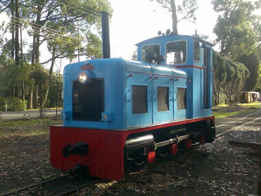 Puffing Billy Railway
Railway Mine and Plantation (RMP) 0-6-0 Diesel Mechanical Locomotive 2' Gauge - "LI'L TOOT", 1951
Builders Number 3354 Build for Inkerman Mill Queensland in 1951 Displayed at the British Industrial Fair at Castle Bromwich, England 1951 prior to delivery to Australia Weight: 10 Tons Known at Inkerman mill as "LI'L TOOT" Major Ernest E. Baguley (1863–1948) was a British engineer.- In the years leading up to the First World War, Baguley served in the Territorial Army and became Second-in-Command, 6th Battalion, North Staffordshire Regiment, rising to the rank of Major. He served in France from 1914 to 1915. Baguley (Engineers) Ltd After the War there was a decline in the production of road vehicles (probably due to competition from other manufacturers) and an increase in the production of railway equipment. The name of the company was changed from Baguley Cars Ltd to Baguley (Engineers) Ltd on 10 April 1923. Following a dispute with their partners Drewry Cars. Ltd, Baguley (Engineers) Ltd went into decline and entered liquidation in 1931. Most of the plant and effects, including Major Baguley's own Baguley car, were sold at auction on 10 November 1931. E. E. Baguley Ltd Major Baguley was a great survivor of WW1 and, he set up a small repair business for Baguley products at Clarence Street, Burton-on-Trent. A new company, E. E. Baguley Ltd, was registered on 30 April 1932 and was soon building locomotives again. In 1934 E. E. Baguley Ltd moved to larger premises at Uxbridge Street, Burton-on-Trent. The company merged with Drewry to form Baguley-Drewry Ltd in 1962.Historic - Industrial Narrow Gauge Railway Diesel Mechanical Locomotive - Pioneer Sugar Mills - Inkerman Sugar Mill, Home Hill, Queensland, AustraliaRail Mine and Plantation (RMP) 0-6-0 Diesel Mechanical 2' Gauge - " LI'L TOOT " Builders Number 3354 Steel (Painted)RMP / 3354 "LI'L TOOT"rmp, diesel, mechanical, locomotive, 2', 2' gauge, puffing billy, inkerman, li'l toot, industrial narrow gauge railway, e. e. baguley ltd, pioneer sugar mills - inkerman sugar mill, rail mine and plantation (rmp) -
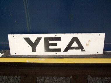 Puffing Billy Railway
Station Sign - Yea
Station Sign - Yea Yea Station Opened 16 November 1883 Closed 8 November 1978 Yea is a former railway station in Yea, Victoria, Australia. The tracks have been removed and the reserve has been turned into The Yea Railway Park consisting of the historic railway station and eleven acres of parkland. It has a picnic shelter, barbecue, toilets, playground, skatepark, walking track, community reserve and includes Rotary Park. The station building houses Blackthorn Textiles (a privately run craft shop). Also on the site are the former goods sheds which are available for hire for varied functions. The Yea Country Market is held in the park on the first Saturday of each month and local artists hold an exhibition and sale in the goods sheds each Easter. The site is listed on the Victorian Heritage Register ref: https://en.wikipedia.org/wiki/Yea_railway_station photo at http://vhd.heritagecouncil.vic.gov.au/vhd-images/places/000/078/092.jpg Historic - Victorian Railways Station sign used at Yea StationStation Sign - Yea Metal rectangle Station Name Sign with white enamel back ground and black lettersYeapuffing billy, station sign, yea station -
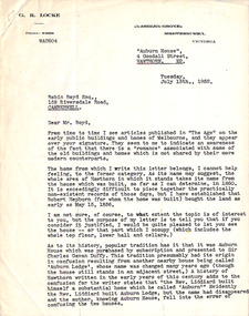 Robin Boyd Foundation
Letter, G. R. Locke, G R Locke to Robin Boyd, 15.07.1952
The letter writer G. R. Locke has read Robin Boyd's newspaper articles on early public buildings and homes. This letter tells Boyd about the historic home "Auburn House", 4 Goodall St Hawthorn, established for Robert Hepburn with land purchased in 1856. It also tells of the confusion with neighbouring house "Auburn Lodge". Since Boyd writes on early Melbourne public buildings and homes, the writer is inviting Boyd to view the house. It is not known whether Robin Boyd took up the invitation. In 1960 it was included in the National Trust Register. -
 Flagstaff Hill Maritime Museum and Village
Ceramic - Roof Tile, c 1914
This terracotta clay roof tile was part of a consignment of tiles in the cargo of ANTARES. THE ANTARES In mid-November 1914, after the beginning of the First World War, a young local man went one evening to fish near the Bay of Islands, west of Peterborough. He later arrived home hurriedly and in an agitated state declaring: "The Germans are coming!" His family laughed and disbelieved him, as this young fellow was prone to telling fictional tales. About a month later, on December 13th 1914, local farmers Phillip Le Couteur and Peter Mathieson were riding in the vicinity, checking on cattle. Phillip Le Couteur saw what he “thought was the hull of a ship below the cliffs.” He rode to Allansford and contacted police. The next day, two Constables and Phillip Le Couteur returned to the site, where they dug a trench near the top of the cliff and sank a log in it. To this they attached a rope, which they threw down the cliff face. Constable Stainsbury and Phillip Le Couteur then made the dangerous descent down the rope on the sheer cliff face. They found wreckage strewn around a small cove and a portion of a man's body under the cliffs. The hull of the ship could be seen about 300 metres out to sea. Some of the wreckage revealed the name Antares and the remains of the ship's dinghy bore the name Sutlej. During the next two weeks and with the help of the Warrnambool lifeboat and crew, two more bodies were found. Later investigations proved that the tragic wreck was indeed that of the Antares, reported overdue on the 207th day of her voyage from Marseilles, France, to Melbourne. She was a three masted, 1749 ton iron clipper, built in Glasgow in 1888 and originally named and launched as the Sutlej. Bought in 1907 by Semider Bros. from Genoa, Italy, she was refitted and renamed Antares. It was later realised that the local lad who a month earlier had declared he had seen German guns being fired, had probably seen distress flares fired from the deck of the Antares the night she was wrecked. She was last sailed under Captain Gazedo and wrecked at what is now known as Antares Rock, near the Bay of Islands. She had been carrying a large cargo of roof tiles from France to Melbourne, consigned to Mullaly & Byrne. Many of them are now to be seen amongst the battered and scattered remains of the wreck. Some of the timbers were found to be blackened by fire. An Information Board has been erected on the cliff top near to the site of the Antares wreck, at the end of Radfords Rd, west of Peterborough. (Ref: Flagstaff Hill Maritime Village’s “Antares” fact sheet, Victorian Heritage Database, Information Board at Peterborough, Flagstaff Hill Significance Assessment 2010) The Antares was one of the last of the 'tall ships' to be lost along the south west coast of Victoria, and is the only wreck that took the lives of all people on board. She is listed on the Victorian Heritage Register VHS S34. The Antares is significant as a sail trader carrying an international inbound cargo. It is part of the Great Ocean Road Historic Shipwreck Trail.Part of a terracotta roof tile from the wreck of the Antares Has sand encrusted to bottom of tile. Artefact Reg No A/6.flagstaff hill, warrnambool, shipwrecked-coast, flagstaff-hill, flagstaff-hill-maritime-museum, maritime-museum, shipwreck-coast, flagstaff-hill-maritime-village, antares, tall ship, peterborough, 1914 shipwreck, phillip le couteur, peter mathieson, constable stainsbury, sutlej, antares rock., bay of islands, terracotta tile, roof tile, clay tile, roofing material, building material -
 Flagstaff Hill Maritime Museum and Village
Geological specimen - Slate, c. 1908
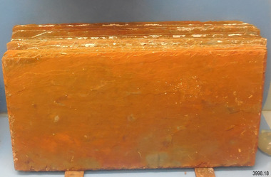
These rectangular slates of 'beautiful, unusual, expensive, green' American roof tiles were recovered from the wreck of the Falls of Halladale. Salvaging began in 1974 by volunteer divers, using local cray-fishing boats. An efficient system was devised to recover up to 4,000 of the still neatly packed slates a day. Many of the 22,000 salvaged slates can be seen on the roofs of eight buildings in the Flagstaff Hill Maritime Village. The iron-hulled, four-masted barque, the Falls of Halladale (1886 - 1908), was a bulk carrier of general cargo. She left New York in August 1908 on her way to Melbourne and Sydney. In her hold, along with 56,763 tiles of unusual beautiful green American slates (roof tiles), 5,673 coils of barbed wire, 600 stoves, 500 sewing machines, 6500 gallons of oil, 14400 gallons of benzene, and many other manufactured items, were 117 cases of crockery and glassware. Three months later and close to her destination, a navigational error caused the Falls of Halladale to be wrecked on a reef off the Peterborough headland at 3 am on the morning of the 15th of November, 1908. The captain and 29 crew members all survived, but her valuable cargo was largely lost, despite two salvage attempts in 1908-09 and 1910. The ship stayed in full sail on the rocky shelf for nearly two months, attracting hundreds of sightseers who watched her slowly disintegrate until the pounding seas and dynamiting by salvagers finally broke her back, and her remains disappeared back into deeper water. The shipwreck is a popular site for divers, about 300m offshore and in 3 – 15m of water. Some of the original cargo can be seen at the site, including pieces of roof slate and coils of barbed wire.The Falls of Halladale shipwreck is listed on the Victorian Heritage Register (No. S255). She was one of the last ships to sail the Trade Routes. She is one of the first vessels to have fore and aft lifting bridges. She is an example of the remains of an International Cargo Ship and also represents aspects of Victoria’s shipping industry The wreck is protected as a Historic Shipwreck under the Commonwealth Historic Shipwrecks Act (1976).Rectangular slates of green American roof tiles, some with a red-brown stain. These are a sample of hundreds of slate roof tiles salvaged from the vessel FALLS of HALLADALENoneflagstaff hill, warrnambool, maritime museum, maritime village, great ocean road, shipwreck coast, cargo, slate, slate tile, green american slates, building material, wreck point, peterborough, bay of islands, russell & co., 1908 shipwreck, salvage, recover -
 Flagstaff Hill Maritime Museum and Village
Photograph, circa 1888
This photograph was taken close to the time of the wreck of the "Edinburgh Castle". The “Edinburgh Castle”, three-masted iron barque, was built in Glasgow, Scotland, in 1863 by J.G. Lawrie. She was 53.7 meters long and weighed 627 tons. She was owned by shipping company T Skinner and Co and registered at Liverpool, England. She sailed from 1863 to 1885 along the trade route between Scotland, China, and Singapore. In 1887 the Master, Captain J.B. Darling, sailed the “Edinburgh Castle” for its new owners Gifford & Nicholson from London to Warrnambool. Her cargo was 4,900 casks of cement for the construction of the new Warrnambool Breakwater. Over the three month journey, the ship met with rough weather and even a hurricane. On January 15th 1888 the “Edinburgh Castle” approached Lady Bay where a welcoming crowd gathered. The Port’s relief Harbour Master, Pilot Carless took over to complete the docking. As he tried to guide her, the Lighthouse Keeper signalled that the ship was too close to shore. The pilot continued on his course, causing her to ‘miss stays’ (make an incorrect tack). The crew dropped anchors and tried to lighten the load by throwing some of the casks of cement overboard but this was to no avail, and she drifted sideways in calm waters, lodging in the sand. A distress signal was sent to the coastal steamer “Julia Percy”, which spent several hours trying to pull the stranded ship away, but it would not budge. Those involved hoped to re-float the ship but efforts to save the vessel were useless. The captain and some crew stayed on board. When the weather became rough the rocket crew brought its lifesaving gear to the shore, ready to launch a line to the ship. The three men on board sent those onshore a message in a bottle to assure the on-lookers that they were quite comfortable to stay aboard. After a night of bad weather, the crew were glad to accept the rocket crew’s help and were in turn safely hauled to shore in a breeches buoy. The ship broke up quickly. Very little of the cargo could be saved. A week later all that could be seen of her was the bow and some of the stern. The beach was littered with wreckage, including cement cask fragments, for weeks. Ironically, on the morning after the ship ran aground, the very same “Edinburgh Castle” was offered for sale at an auction in Melbourne, billed as “a sound ship with all the fittings and in the best order.” The sale was completed before they heard the news that the ship was totally wrecked! Over the decades the shifting sands concealed the wreck of “Edinburgh Castle”. However, in October 1985 two local divers, Peter Ronald and Colin Goodall discovered her near the Hopkins River mouth. Peter said in his book ‘Exploring Shipwrecks of Western Victoria’, “In the midst of this sand-cloud I could clearly see row after row of neatly stacked barrels”. He remarked, “I am privileged to have had at least a glimpse of one of Warrnambool's most significant wrecks.” Some 15 – 17 ships are believed to have sunk in Lady Bay, but only two have been discovered on the seafloor; the “Edinburgh Castle” and the “La Bella”. Both wrecks are popular diving sites and are preserved as significant historical marine and marine archaeological sites. The sailing ship “Edinburgh Castle” is of local and state and national significance. It is one of the only two shipwrecks discovered in Lady Bay, Warrnambool, out of the 15-17 shipwrecks in the bay. The “Edinburgh Castle” is significant for being one of the largest vessels lost in the bay. The significance of the wreck of the “Edinburgh Castle” was recognised by being listed on the Victorian Heritage Database VHR S209. She was declared an Historic Shipwreck on 17th January 1989 under the Commonwealth Historic Shipwrecks Act (1976). The “Edinburgh Castle” wreck is also significant for the connection of its cargo with the building of the Warrnambool Breakwater, also listed on the Victorian Heritage Database VHR H2024. The “Edinburgh Castle” is included as one of the shipwrecks in Heritage Victoria’s Historic Shipwreck Trail on Victoria’s West Coast. Black and white photograph of the iron barque 'Edinburgh Castle' on breaking waves, land in the background. The ship was stranded and wrecked in Lady Bay, Warrnambool, on January 15th 1888. Figures are standing on deck. The masts are free from sails.flagstaff hill, warrnambool, shipwrecked-coast, flagstaff-hill, flagstaff-hill-maritime-museum, maritime-museum, shipwreck-coast, flagstaff-hill-maritime-village, great ocean road, edinburgh castle barque 1863, edinburgh castle shipwreck 1888, shipwreck 15-05-1888, glasgow ship, jg lawrie, t skinner and co, liverpool ship register, captain j.b. darling, gifford & nicholson, cement casks, cement barrels, warrnambool breakwater construction, breaches buoy, rocket crew, rocket launcher, lifesaving equipment, warrnambool harbour, lady bay warrnambool, ship pilot carless, lady bay shipwreck, peter ronald, colin goodall, lady bay diving site, marine archaeology, victorian heritage register, vhr s209 -
 Flagstaff Hill Maritime Museum and Village
Geological specimen - Slate Roof Tiles
These rectangular slates of 'beautiful, unusual, expensive, green' American roof tiles were recovered from the wreck of the Falls of Halladale. Salvaging began in 1974 by volunteer divers, using local cray-fishing boats. An efficient system was devised to recover up to 4,000 of the still neatly packed slates a day. Many of the 22,000 salvaged slates can be seen on the roofs of eight Flagstaff Hill Maritime Village buildings. The iron-hulled, four-masted barque, the Falls of Halladale (1886 - 1908), was a bulk carrier of general cargo. She left New York in August 1908 on her way to Melbourne and Sydney. In her hold, along with 56,763 tiles of unusual beautiful green American slates (roof tiles), 5,673 coils of barbed wire, 600 stoves, 500 sewing machines, 6500 gallons of oil, 14400 gallons of benzene, and many other manufactured items, were 117 cases of crockery and glassware. Three months later and close to her destination, a navigational error caused the Falls of Halladale to be wrecked, grounded on a reef at Wreck Point, midway between Peterborough and the Bay of Islands, during the night of 14th November 1908. The captain and 29 crew members all survived, but her valuable cargo was largely lost, despite two salvage attempts in 1908-09 and 1910. The ship stayed in full sail on the rocky shelf for nearly two months, attracting hundreds of sightseers who watched her slowly disintegrate until the pounding seas and dynamiting by salvagers finally broke her back, and her remains disappeared back into deeper water. The shipwreck is a popular site for divers, about 300m offshore and in 3 – 15m of water. Some of the original cargo can be seen at the site, including pieces of roof slate and coils of barbed wire.The American slate tiles are significant as an example of cargo imported for use as building materials in Australia. The Falls of Halladale shipwreck is listed on the Victorian Heritage Register (No. S255). She was one of the last ships to sail the Trade Routes. She is one of the first vessels to have fore and aft lifting bridges. She is an example of the remains of an International Cargo Ship and also represents aspects of Victoria’s shipping industry The wreck is protected as a Historic Shipwreck under the Commonwealth Historic Shipwrecks Act (1976).Bundle of slate roof tiles (18); rectangular, green American slate roof tiles, some with red-brown stains. Two tiles both have two holes drilled through them. Two different tiles are thicker than the others. The tiles were salvaged from the wreck of Falls of Halladale. flagstaff hill, warrnambool, maritime village, maritime museum, shipwreck coast, great ocean road, cargo, slate, slate tile, green american slates, building material, wreck point, peterborough, bay of islands, russell & co., 1908 shipwreck, salvage, recover -
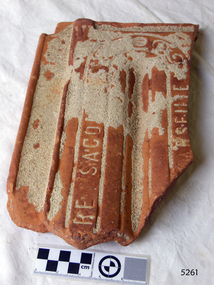
 Flagstaff Hill Maritime Museum and Village
Ceramic - Roof Tile, Circa 1914
This portion of terracotta roof tile was salvaged from the wreck of the Antares by Flagstaff Hill diver, Peter Ronald. It has letters, numbers and symbols impressed into the clay by the manufacturer. The Italian barque Antares was an iron three-masted sailing clipper built in 1888 by Russell & Co of Port Glasgow originally named the “Sutlej” and renamed in 1907 the “Antares” when sold to the Semider Bros of Genoa Italy. The vessel left Marseilles on the 18th of December 1913 with its master captain Gazedo destined for Mullaly & Byrne of Melbourne with a cargo of roof tiles but failed to arrive. The wreckage was found near the Bay of Islands twenty-two miles east of Warrnambool after a body had washed ashore. Some of the timbers washed up were charred by fire, and a small boat's stern board with the name "Sutlej" led to the identification of the wreck as Antares which had been reported missing. According to later reports, the Antares wrecking was overshadowed by war news at the time. A young local boy had remarked that the Germans had arrived off the coast as he had seen them firing off shells and rockets, but his story was passed off as a joke. These rockets were most likely the distress signals from the stricken ship. The Italian barque/clipper Antares was sometime later reported as overdue. The wreck of the ship was later found at the base of a cliff at the Bay of Islands near Warrnambool in November 1914, there were no survivors.This tile is significant in its association with the wreck of Antares and is registered as a Shipwreck Artefact A/2. This tile is significant for its association with the sailing ship Antares, one of the last of the 'tall ships' to be lost along the southwest coast of Victoria, and the only wreck that took the lives of all people on board. The significance is recognised by its listing on the Victorian Heritage Register VHS S34. The Antares is significant as a sail trader carrying international inbound cargo. It is part of the Great Ocean Road Historic Shipwreck Trail.Roof tile; terracotta clay tile shaped for fitting together with other tiles. Inscriptions are impressed into the clay. It was recovered from the wreck of the Antares. Impressed text:”- E R I E S DE LA MEDITERRANEE” “ … T S – MI-LES BOU- R …..” Impressed symbol: (Sideways crown or tree) (could be TULLERIES DE LA MEDITERRANEE)flagstaff hill, warrnambool, flagstaff hill maritime museum, maritime museum, shipwreck coast, flagstaff hill maritime village, great ocean road, roofing tile, building materials, antares, peterborough, 1914 shipwreck, sutlej, antares rock., bay of islands, terracotta tile, clipper, roof tile, building material -
 Eltham District Historical Society Inc
Document - Binder, Eltham Justice Precinct, 1969-2020
EDHS_04863 - Binder: Eltham Justice Precinct 1. Courthouse 1. Eltham Courthouse interesting facts 2. Plan and elevation drawings 3. Other courthouse plans and fittings 1880s – Brunswick, Maffra, Dunolly , Sunbury, Landsborough and Wodonga 4. Newspaper articles: i. ELTHAM POLICE COURT. (1892, April 1). Evelyn Observer, and South and East Bourke Record (Vic. : 1882 - 1902), p. 2 (MORNING.). Retrieved July 5, 2022, from http://nla.gov.au/nla.news-article60667022 ii. BREAKING A PUBLICAN'S LEG. (1900, July 13). Evelyn Observer, and South and East Bourke Record (Vic. : 1882 - 1902), p. 2 (MORNING.). Retrieved July 5, 2022, from http://nla.gov.au/nla.news-article60688367 iii. ELTHAM COURT. (1901, March 1). Mercury and Weekly Courier (Vic. : 1878 - 1903), p. 3. Retrieved July 5, 2022, from http://nla.gov.au/nla.news-article58578953 iv. ANNIE CHASES A TINKER. (1902, October 3). Evelyn Observer, and South and East Bourke Record (Vic. : 1882 - 1902), p. 2 (MORNING.). Retrieved July 5, 2022, from http://nla.gov.au/nla.news-article64029968 v. ELTHAM POLICE COURT. (1927, May 6). Advertiser (Hurstbridge, Vic. : 1922 - 1939), p. 4 (AFTERNOON). Retrieved July 5, 2022, from http://nla.gov.au/nla.news-article57754748 vi. ELTHAM POLICE COURT. (1927, May 20). Advertiser (Hurstbridge, Vic. : 1922 - 1939), p. 3 (AFTERNOON). Retrieved July 5, 2022, from http://nla.gov.au/nla.news-article57754814 vii. Eltham Police Court (1931, January 9). Advertiser (Hurstbridge, Vic. : 1922 - 1939), p. 4. Retrieved July 5, 2022, from http://nla.gov.au/nla.news-article56734073 viii. Repairs to Eltham Police Station, The Advertiser (1929, May 24). Advertiser (Hurstbridge, Vic. : 1922 - 1939), p. 2 (AFTERNOON.). Retrieved July 5, 2022, from http://nla.gov.au/nla.news-article57759907 ix. ELTHAM COURT. (1929, August 2). Advertiser (Hurstbridge, Vic. : 1922 - 1939), p. 4 (AFTERNOON.). Retrieved July 5, 2022, from http://nla.gov.au/nla.news-article57760345 x. See also Trove list https://trove.nla.gov.au/list/116634 5. Letter: Shire of Eltham Historical Society to Shire of Eltham, 1 July 1969 regarding potential replacement of Eltham Courthouse and the building’s historical significance and acknowledgement 10 July 1969 6. Letter: Shire of Eltham Historical Society to Law Department, 26 May 1972, re preservation of Eltham Courthouse and potential classification and acknowledgement 7 June 1972 7. Newspaper article: Strangers around, so Eltham sought protection by Marguerite Marshall, Diamond Valley News, Tuesday, April 6, 1982, p2 (On reverse side, Top job for our Pauline, p1) 8. Eltham Courthouse Colour Scheme, Public Works Department, 10 September 1983 9. Newspaper article: Eltham Courthouse under threat of closure by Helen Gillman, Diamond Valley News, October 16, 1984 10. Newspaper article: Courthouse to close by Helen Gillman, Diamond Valley News, Tuesday, November 20, 1984, p1 (also on p2 an article about Diamond Valley Shire festivities for the State’s 150th) 11. We will keep your court – Kennett, Diamond Valley News (probable), c.Dec. 1984 12. Letter: Shire of Eltham to Shire of Eltham Historical Society, 15 March 1985, regarding potential for use of building as a museum and reply dated 17 April 1985 regarding Society’s interest in use of the building 13. Letter: Department of Conservation Forests & Lands to Shire of Eltham, August 1987, regarding expressions of interest in the building and letter from Shire (18 August 1987) to Society advising of same 14. Letter: Department of Conservation Forests & Lands to Shire of Eltham, 30 March 1988, advising Courthouse to be used by Eltham Youth Resources Centre and the rear section by other community groups. Noted that the historical society was suggested by Council as a future user of the adjoining police residence when Council first sought management of the building and that should be investigated. Includes Schedule of Repair and Maintenance Work (4 pages), Existing Conditions Survey 30/7/1987 (6 pages) and 1 page plan view diagram 15. Memo: Historic Places Section to Eltham Youth Resource Centre re paint analysis of Courthouse, 17/5/1988, (6 pages) 16. Newspaper article: Courthouse renovation by Jodie Haythorne, Diamond Valley News, November 23, 1992 17. National Trust of Australia Registration (classified 20 Oct 1977), printed March 2000 18. Letter: Heritage Victoria 28 Feb 2002 regarding the replacement of the Courthouse Stand (Witness Box) 19. Article: There’s still order in this stately court house, Eltham Shire (magazine), date unk., p22-23 20. Eltham Court House, Statement of Significance, Heritage Victoria Register, printed Nov 2004 21. Eltham 1860 Former Court House 730 Main Road Eltham, collated by Eltham District Historical Society Incorporated 2005 (4 pages) 22. Book Extract: Eltham, Historical Court Houses of Victoria by Michael Challinger, Palisade Press, 2001 23. Newspaper article: Courthouse rich with history by Harry Gilham, Nillumbik Mail, c.2001 (see also EDHS_03333) 24. Notes on history of site from Crown Reserve File Rs 12128, Municipal Buildings (Local Community Welfare Reserve) at Eltham, Department of Sustainability and Environment, April 2005 (4 pages) 25. Newspaper article: Historic building upgrade, Diamond Valley Leader, August 3, 2005, p17 26. Newspaper article: Courthouse regeneration secures boost, Valley Weekly, August 10, 2005 with picture of Harry Gilham, Steve Herbert and Greg Johnson 27. Newspaper article: Poets are summonsed, Diamond Valley Leader February 22, 2006, p37 features picture of Helen Lucas at the Eltham Courthouse 28. Newspaper article: Sharing a love of legalities, Diamond Valley Leader, March 1, 2006, p7 features a picture of Rob Hulls and Steve Herbert talking to students in the courthouse 29. Newspaper advertisement: Nillumbik Tender No. 2021-33, Building Restoration Works, Old Eltham Courthouse, The Age, November 7, 2020 30. Form: Police Officer’s Return To A Warrant Of Distress 31. Handwritten notes: three pages listing all 48 of the pigeon hole form listings in the cabinet in the courthouse 2. Police Quarters 1. 1971 Surveyors Plan of 728 Main Road and the Adjoining Courthouse 2. Letter: Shire of Eltham to Shire of Eltham Historical Society, 5 June 1981, requesting the society give consideration to the suitability of the existing buildings (former Vermin and Noxious Weeds Office, Department of Crown Lands and Survey) for historical purposes such as a museum 3. Minutes: Shire of Eltham Historical Society Committee Meeting, 10 June 1981 (2 pages) includes reference to possible use of building as a museum (also reference to Bills Horse trough to be retained) 4. Extract from Victoria Police Gazette 1930 with details of building and site 5. Newspaper article: Cubby haven, Diamond Valley News, October 28, 1991 about replica Police Station with picture of replica along with Monika Roitinger and Garry Bartlett outside the Police Station 6. Environment office up for sale? Mountain Views, Monday, June 12, 1995 (Nillumbik Shire Council proposing to sell property. Did not proceed as ownership held by the State of Victoria) 7. Extract from National Trust February 1998 edition, “Police Rescue” which states Heidelberg and Eltham Police Residences are the oldest known Police Residences in the Melbourne Metropolitan district 8. Newspaper article: The first police office by Harry Gilham, Nillumbik Mail, December 13, 2000 (also photocopy with notations on picture identifying buildings and Harry’s typed draft) 9. Fax Memo: Victoria Police List of Officers in Charge, Eltham Police Station, 1857-1991 onward, 21 Jan 2003 10. Former Police Quarters, Statement of Significance, Heritage Victoria Register, printed Nov 2004 11. Eltham 1860 Former Police Quarters 728 Main Road Eltham, collated by Eltham District Historical Society Incorporated 2005 (5 pages) 12. Report: Eltham District Historical Society to Living and Learning Nillumbik, 14 April 2010 regarding the poor state of condition of the former Police Residence 13. Photocopy of three photos of the former Police Residence, former Police Station (relocated to rear of site) and Stables, October 18, 1991 3. Lockup 1. Newspaper article: Heritage permit bid, Diamond Valley News, January 17, 2001 (also article “Eltham library tops”) includes picture of lockup located in Youth Road 2. Newspaper article: Old lockup in new site, Diamond Valley Leader, March 21, 2001, p15. Includes picture of Harry Gilham with lockup at justice Precinct 3. Letter: Victoria Police to Eltham District Historical Society, 20 March 1991 including laser print photo of lockup in 1963 at 23 Pryor Street 4. Fax: Graham Clark, Associated Crane Trucks Pty Ltd, 833 Main Road Hurstbridge; Quote 26.2.99 for $1,080 to move lockup from Youth Road to 728 Main Road 4. Local History Centre 1. Victoria Government Gazette: Photocopy, No. 165, Tuesday, December 7, 1858, establishment of a Court of Petty Sessions at Eltham, 7 December 1858 2. Victoria Government Gazette: Photocopy, September 16, 1859, contract issued for Police buildings at Eltham to Langridge and Co., McCarter, Baillie, Nicol and Co, Chadley, Amos and Co., Cameron, Payne, £1,150.7.0 3. Victoria Government Gazette: Photocopy, October 2, 1860, contract issued for Court of Petty Sessions at Eltham to James Duncan, £600 4. President’s Report, Eltham District Historical Society, Annual General Meeting, Wednesday, March 11, 1998 – covers the establishment of the Local History Centre and new home for the Society 5. Extract for EDHS Newsletter July 1998 – Eltham Local History Centre – Official Opening 6. Unveiling of 728 Street Sign, Speech notes by Cr Dianne Bullen, December 2000, includes invoice from John Sharp Signs Pty Ltd, 24/10/2000 and planning approval drawing dated 24/3/1999 reproduced in Newsletter No. 135 November 2000 7. Letter: Eltham District Historical Society to Living and Learning Centre, undated draft regarding being a member of the committee reviewing the development of the site 8. Notes from Rod Grant re funding of site development under the Community Jobs Program 9. Letter: Eltham District Historical Society to Nillumbik Living and Learning, 28 October 2004 re inclusion of the Society in enhancing the site under the Community Jobs Program 10. Letter: Department of Sustainability and Environment to Eltham District Historical Society, 28 February 2005 re preparing draft Conservation Plan and copy of cover letter in response 2 April 2005 11. Levels and Layout Plan, Nillumbik Shire Council, September 2005, AO copy 12. Letter: Department of Sustainability and Environment to Eltham District Historical Society, 12 September 2005 re Eltham Justice Precinct Conservation Management Plan 13. Letter: Living and Learning Nillumbik, 2 February 2006 to Eltham District Historical Society re forming a Committee to advise on the use, maintenance, management and preservation of the Justice Precinct 14. Minutes: Meeting of a Task group to explore the establishment of a Committee to manage the Eltham Justice Precinct, 20 December 2005 (with hand written notes) 15. President’s notes (EDHS), General Meeting item, 11 May 2006 pertaining to use and condition of the Eltham Justice Precinct 16. Paint estimates, Old Eltham Court House, undated 17. Notes from meeting 26 September (2006), Eltham Justice Precinct Committee 18. Notes from meeting 27 November (2006), Eltham Justice Precinct Committee 19. Terms of Reference for the Eltham Justice Precinct Committee, Draft for Living and Learning Committee Meeting 24 Jan 2007 (4 pages) 20. Newspaper article: Panel set up, Diamond Valley Leader, 7 March 2007 21. Minutes: Meeting of Eltham Justice Precinct Subcommittee, 10 May 2007 22. Minutes: Meeting of Eltham Justice Precinct Subcommittee, 5 July 2007 23. Minutes: Meeting of Eltham Justice Precinct Subcommittee, 11 October 2007 24. Minutes: Meeting of Eltham Justice Precinct Subcommittee, 7 February 2008 25. Minutes: Meeting of Eltham Justice Precinct Subcommittee, 10 April 2008 26. Minutes: Meeting of Eltham Justice Precinct Subcommittee, 14 August 2008 27. Letter: EDHS (Sue Law) to Living and Learning, 6 September 2008 re proposed signage 28. Agenda: Meeting of Eltham Justice Precinct Subcommittee, 16 October 2008 29. Suggested guidelines for use of the Court House for exhibitions 30. Handwritten note re Ken Eckersal and Uniting Church of possible donation of church organ for sale, proceeds to be used for activities at the Justice precinct 31. One page typed notes on each of the buildings in the Eltham Justice Precinct 5. Miscellaneous 1. Photocopy from Pioneers & Painters (2 pages) covering the establishment of Police and Court of Petty Sessions at Eltham 2. Photocopy of photo looking northeast across Little Eltham buildings c.1910 with notes 3. Photocopy of J.H Clarke photo looking up Maria Street from near Dalton Street with notes identifying precinct buildings 4. Photocopy of photo of Court House and Police Quarters with cow outside from Heather Jenkins scrapbook with notes identifying buildings 5. Sketch and notes with dimensions for blue stone lockup including other miscellaneous handwritten notes 6. Unidentified heritage review details of Justice Precinct (c.2004) 7. Hand written notes of telephone conversation held with Dennis McKay (6 May 1997) re Council use of site 8. Flyer: Victoria Police Historical Unit 9. Photocopy of thumbnail images of various Justice Precincts (not identified) 10. Email correspondence, 4 and 10 January 2008; J. Connor to Council and Councillors pertaining to proposed new toilet facilities at rear of Courthouse annexe. Two ring lever arch binder, white with various photocopies, printouts, newspaper clippingsHG Folders 15/52/59 integratedharry gilham collection, eltham courthouse, eltham justice precinct, eltham police residence, lockup, eltham community festival, eltham festival, eltham, heritage assessment, police residence -
 Eltham District Historical Society Inc
Document, Russell Yeoman, Tour of Historic Buildings and Locations, 1978
... on the Register of Historic Buildings. 17. NO. 86 PITT STREET Cottage... on the Register of Historic Buildings. 17. NO. 86 PITT STREET Cottage ...Self guided heritage tour information produced by the Shire of Eltham Historical Society for 1978 Eltham Community Festival of 36 locations each numbered on accompanying map. Locations and detail provided current to 1978: 1. ELTHAM SHOPPING CENTRE Whilst very little remains in the centre of historical importance, this area has interest as the "village" which developed over many years following the opening of the railway from Melbourne in 1902. Previously the shopping centre had been spread out over a long length of Main Road to the south. Shops have been continuously demolished or remodelled and the majority of buildings date from the 1950's or later. The recently erected Post Office replaced the "old" Post Office opened on the same site only in 1958. 2. WOOLWORTHS ELTHAM VILLAGE Part of the site of this modern shopping development was occupied by the former Eltham Shire Offices and Hall. The hall was paid for by public subscription whilst the Council raised a loan for the offices. The combined building was opened in 1941. It served as office and Council meeting place until 1965 and as the hall until its demolition in 1970. 3. ELTHAM WAR MEMORIAL The complex of buildings adjoining the present Shire Offices were financed by public subscription as a Memorial following World War II. Their construction and for many years their operation was organised by the now disbanded Eltham War Memorial Committee. The original buildings were the; Infant Welfare Centre, Children’s Library (now War Memorial Hall and Dental Clinic) and Kindergarten. In later years the Elderly Citizens Club was built at the rear. 4. ELTHAM SHIRE OFFICES These offices were opened in 1965 and extended in 1971 to provide additional office accommodation and the Eltham Library. They represent the last of a long line of offices and meeting places of the Eltham Shire Council and its predecessor the Eltham District Road Board. The building occupies the former site of Shillinglaw Cottage. The three tall cypress trees which stood in front of the Cottage have been retained as a feature of the office surrounds. 5. OUR LADY'S CHURCH AND SCHOOL The Catholic Church and School complex opposite the Shires Offices shows a number of stages in the development of Eltham township. The recently constructed church adjoins its predecessor (now the parish centre). Many years ago the Catholic Church was located opposite Wingrove Park and the present central site follows the northerly drift of the township. 6. SHILLINGLAW COTTAGE The Cottage was built in 1859 by George Stebbing, a local builder who was responsible for a number of other prominent buildings in the area. Its removal from the site of the Shire Offices and re-erection on the present site was financed by public subscription. It is built of handmade bricks laid in Flemish Bond with an unusual design featuring burnt "leader" bricks over the whole facade. The Cottage is occupied by Eltham Fleececrafts and will be open during the Festival and at other times during weekends. It is classified by the National Trust. 7. RAILWAY BRIDGE The timber trestle bridge over the Diamond Creek was built in 1901. Whilst all of its timbers have been replaced at various times over the years the only change to its character has been the addition of pylons and wiring for electric trains in 1923. It is one of very few similar bridges remaining in the metropolitan area. In 1976 a proposal to replace the bridge with an earth embankment and large culvert pipes was abandoned following community protests. The bridge, however, remains under threat because of the necessity for future deuplication of the railway line. 8. ELTHAM CENTPAL PARK The area between the railway and the creek has for many years been used as a park which included Eltham' s main football oval. The access road, Panther Place is named after Eltham's team playing in the Diamond Valley League. In recent years a large area extending to Bridge Street and locally known as the Town Park has been landscaped and added to the area. The excellent blending of the park with the natural landscape of the creek valley has earned a National Trust Landscape Classification. 9. OLD BAKERY On the southern corner of York Street and Main Road is an old house with a shop front which was for many years the local baker's shop. The brick bakery at the rear is of somewhat later vintage than the house. 10. BRIDGE STREET CUTTING Before reconstruction of Main Road this intersection had deep cutting embankments on all four corners, forming a distinctive feature of the entrance to Eltham. Roadworks and private development have levelled the land on the low side of the road. A memorial to the Eltham soldiers of World War I which was located at the north-western corner is now situated at the Eltham R.S.L. 11. HILLTOP MILK BAR For many years this was the site of the Eltham Post Office under the control of the Hunniford family and later their descendants the Burgoynes. It was transferred to this site in 1855, although at that time the building apparently fronted Bridge Str e et. The site contained Eltham's first telephone exchange. The post office was relocated in 1954 but the shop was operated until recently by the Burgoyne family who still own the surrounding land. 12. UNITING CHURCH and former C.B.A. BANK The former Methodist Church was built in 1880 by George Stebbing. The Sunday School extension was built in 1929 and there have been more recent extensions. The adjoining opportunity shop was built as a bank in 1874 and purchased by the Methodist Church in 1954. 13. R.S.L. HALL, TELEPHONE EXCHANGE These relatively recent buildings occupy the site of a row of shops forming part of the early ribbon of business development along Main Road. In front of the R.S.L. building is the World War I Memorial relocated from the corner of Bridge Street and Main Road. 14. ELTHAM COMMUNITY CENTRE Australia's first mudbrick "community building" was opened in April this year. Part of the site of the building was purchased in 1856 by Henry Dendy (of Brighton fame). At the rear of the land near the creek was a steam flour mill whilst Dendy's house was at the Main Road frontage of the land. His purchase totalled about 2 Ha (5 acres) and included land on the opposite side of Maria Street (Main Road). Dendy became a prominent member of the Eltham community and served one term as President of the Eltham District Road Board. In 1867 Dendy sold his land and business to William Ford of Malmsbury and shifted to Walhalla. The avenue of trees leading past the Community Centre to the creek may well have bordered the track to the mill. 15. ELTHAM HOTEL The original part of this hotel was built in 1927 following the burning of the former Watson's Eltham Hotel on the same site. The car park on the opposite side of Main Road was also the site of a hotel variously known over the years as; the Fountain of Friendship, the Fountain and the Evelyn Arms. As the Fountain of Friendship it was the first meeting place of the Eltham District Road Board in 1856. 16. ST. MARGARET'S CHURCH, PITT STREET In 1860 Henry Dendy was appointed Chairman of a committee to establish a church of England in Eltham. He donated part of his land in Pitt Street and in 1861 the church was opened. It was built by George Stebbing and remains in a well preserved state today. Th adjoining old vicarage is now named Dendy Hou se. A new mudbrick church hall is under construction on the site. The church and Dendy House are now listed on the Register of Historic Buildings. 17. NO. 86 PITT STREET Cottage built by George Stebbing and believed to be his home for some years in the 1850s. 18. LIVING AND LEARNING CENTRE The house was built in the 1850s with the kitchen at the front being added about 40 years later. By the creek below the house a number of early Eltham industries were located. These included a tannery and a brewery. 19. ELTHAM COURT HOUSE A Court of Petty Sessions was established in Eltham in 1858 and the present building dates from 1860. It is the oldest public building remaining in Eltham. In its early days the building was used as the meeting place and office of the Eltham District Road Board and as an overflow classroom for the local school. The Court House has been classified by the National Trust. The citation states that it is an example of the simple form of early brick Court House with gabled roof and porch. 20. LANDS DEPARTMENT OFFICE This building is the former police station and is probably of about the same age as the Court House. The lockup at the rear has been demolished but the old stables remain as garages. A licence was first granted for a police station at Eltham in 1856. 21. JARROLD COTTAGE The old Cottage opposite Dalton Street was formerly owned by the Jarrold family. Early records indicate that this was the building leased from the Jarrolds as a temporary police station prior to construction of the building on the corner of Brougham Street. The small building on the corner of the property was used as a boot repairer's shop. The elevated studio at the rear is a more recent construction by the present owners. 22. STATE SCHOOL RESIDENCE Erected in 1891 23. WINGROVE COTTAGE This building fills an important place in the history of Eltham and is now used as a medical clinic. It was built in 1858 for Charles S. Wingrove who was Secretary to the Eltham District Road Board and Shire Council from 1858 to 1904. During part of this period he was also Shire Engineer and was Secretary to the Heidelberg Road Board. The house was used as the office of the Board and Council for many years. Wingrove is buried in the cemetery at St. Helena. 24. WINGROVE PARK The parkland opposite Wingrove Cottage has been named after Charles Wingrove. The old Manna Gums are an outstanding feature of the park. 25. ELTHAM FRI.MARY SCHOOL NO. 209 The school first opened in the slab building in 1855 and operated from the present site since 1857. The oldest part of the present school is the stone building erected in 1876. The first school teacher, David Clark remained at the school until 1888. This school is the government township and has always been known as the Eltham School. An earlier school (no.371) known as Little Eltham School operated in Swan Street from 1853 to 1872. 26. "SHOESTRING" This house was built for school teacher David Clark. It has been extensively extended in recent years but the extensions do not detract from the character of the older part of the building. 27. ELTHAM CEMETERY The cemetery contains the graves of many of the district's pioneers . 28. MONTSALVAT This unique complex of buildings was commenced in 1935 by the late Justus Jorgensen and its development has extended over many years. Montsalvat has exerted a significant impact on Eltham The earth and stone construction of many of the buildings has influenced local architecture to a great extent and it has served as a "nerve centre" of the local artistic community. Montsalvat is open to the public for a small charge. 29. MAIN ROAD BRIDGE This location has been the main crossing of Diamond Creek since the earliest days of settlement. The present concrete bridge was erected in 1925 .and was preceded by a number of timber bridges. 30. ELTHAM LOWER PARK This park, being an unusually large flat area for Eltham, was originally the local racecourse. Horse races were held here from 1855 and the area was gazetted as a reserve for a racecourse and recreation reserve in 1857. The park is well known as a venue for school "bird days" and more recently as the site of the Diamond Valley Railway. This miniature railway features scale models of modern and old locomotives and rolling stock and has operated on this site since 1961 . Before that the railway operated at Chelsworth Park, Ivanhoe. 31. FALKINER HOUSE Frederick Falkiner was one of the earliest settlers in the Eltham township area and occupied a substantial leasehold prior to the first land sales. Early records show that Falkiner was the subject of a number of complaints from his neighbours but he has nevertheless been considered a prominent enough citizen to have a street named for him. This house was the home of Evelyn (Ely) Falkiner a member of Frederick's family. 32. WEST HOUSE Behind the large house on the hill is an early house built by the West family. This was relocated from a site near the front of the land by the present owner Mr. Fabbro. 33. FALKINER HOUSE This very old house is believed to have been the home of Frederick and may have been Eltham's first post office. Falkiner was the first post master for a short period. in 1854/55. 34. WITHERS HOUSE This house was the home of famous artist Walter Withers who shifted here from Heidelberg in 1903. 35. ELTHAM HIGH SCHOOL This school celebrated its jubilee this year, having commenced as the Eltham Higher Elementary School 50 years ago. 36. DIAMOND CREEK FOOTWAY If returning from the High School to the town centre the footpath by the bank of the Diamond Creek provides a pleasant route to finish your walk. The creek is a major tributary of the Yarra River. Together with its own major tributaries Arthurs Creek and Running Creek it commences on the southern slopes of the Dividing Range at Kinglake. It gives the name Diamond Valley to an area extending well beyond its actual drainage catchment.Recognition of the significance of various landmarks to the history of the Eltham community as of 1978‘shoestring’, 1978, bridge street cutting, burgoyne store, c.b.a. bank, diamond creek trail, eltham cemetery, eltham central park, eltham community centre, eltham community festival, eltham court house, eltham festival, eltham high school, eltham hotel, eltham lower park, eltham primary school, eltham railway trestle bridge, eltham shire offices, eltham shopping centre, eltham state school no. 209, eltham village, eltham war memorial, falkiner house, heritage trail, hilltop milk bar, jarrold cottage, lands department office, living, living and learning centre, main road bridge, montsalvat, old bakery, our eltham artistic recollections, our lady help of christian’s church, our lady help of christian’s primary school, pitt street, post office, r.s.l. hall, shillinglaw cottage, st margaret’s church, state school residence, stebbing cottage, telephone exchange, uniting church, west house, wingrove cottage, wingrove park, withers house, woolworths -
 Old Gippstown
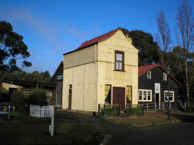
Building - Loren Iron House, 1859
Loren (formerly James Hogg's house) is a two-storey gabled prefabricated house, constructed using broad-gauge corrugated iron and was originally erected in 60-62 Curzon Street, North Melbourne in 1854 for builder, James Hogg. By 1968 the building had deteriorated and it was dismantled and moved to the Old Gippstown where it was re-erected and restored. The building's external framing system consists of exposed metal columns with Gothic panel motifs at the corners. Internally the timber framed walls have been finished with new papers over new Hessian. The corrugated iron roof has an unusual concave form and the windows, floors and doors are of moulded softwood.State historic significance as a rare type of iron prefab. house. Listed on the Victorian Heritage Register and covered by a Heritage Overlay, Latrobe City Planning Scheme.Tall square-shaped two-storey corrugated iron building with a curved corrugated iron roof with two outside brick chimneys. prefabricated iron houses -
 Whittlesea Historical Society Inc.
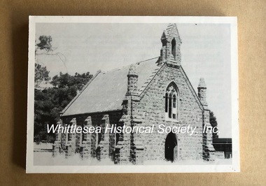
Photograph, St John's Presbyterian Church, Cameron Street, Kal Kallo
This photograph forms part of a collection of photographs gathered by the Whittlesea Historical Society for their project book, "Historic Views of the City of Whittlesea" by Robert Wuchatsch and Gwen Hawke, as part of Australia's Bicentennial Celebrations in 1988. The collection contains over 200 historic photographs covering all aspects of early life in the area now embraced by the City of Whittlesea.This bluestone church, which was dedicated on 9 Dec 1860, had been erected earlier that year by William Brown of Darraweit Guim. It was designed by the architect Thomas Taylor. The building is classified by the National Trust, and included on the Register of the National Estate.Black and white print mounted on a foam backing for display.historic views of the city of whittlesea, st john's presbyterian church, kalkallo, bluestone church, kal kallo -
 Parks Victoria - Gabo Island Lightstation
Telephone
Telephones x 3 (GILS 0001, 0038, 0070; attached fixtures) There are three, black Bakelite, wall mounted, crank handle telephones across the lightstation; one in the former assistant keeper’s quarters, and two in the former head keeper’s quarters. The phone has instructions for its use on the crank dial. Two have acoiled handset cord, which dates the phone to just after 1949 when these came into use. The third has a smooth cord and must pre date 1949 (GILS 0070). Another much older wallmounted phone remains in the lighthouse (GILS 0041; attached fixture; see above 6.1). The four telephones at Gabo Island formed an intercom system that facilitated communication between the lighthouse and lightstation buildings. They demonstrate the necessity for employing various methods of communication in a remotely located lighthouse as well as communication between the lightstation buildings. Telephones of the same wall mounted, crank dial type remain at Cape Otway and Point Hicks As fixtures, the telephones belong to the building fabric and are included in the existing listing of the Gabo Island Lightstation in the Victorian Heritage Register (H1773). These intact items of equipment have first level contributory significance for their historic value and provenance.Black bakelite telephone, wall mounted with reciever/ handset on spiral cord attached to the body of the phone. There is a crank handle attached to the front of the telephone.On dial under crank handle. Outer perimeter of circular LABEL,"TO CALL:-TURN HANDLE & LIFT HANDSET / WHEN FINISHED PEPLACE HANDSET & TURN HANDLE" -
 Parks Victoria - Gabo Island Lightstation
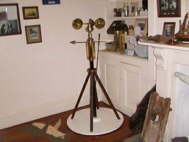
Anemometer
This device was used to measure surface wind speed and direction. This anemometer was located on a concrete pad outside room 2.15 on a steel pole. The pole was considered unsafe and the anemometer was relocated to it's current position. When lowering the pole it fell over and was badly damaged. The Bureau of Meteorology donated it to the museum. It was then repaired and restored. The central pole on which it is mounted is galvanised iron pipe painted black. The anemometer, a portable device that manually measures wind speed, was a necessary instrument once common to all weather stations. The arms are attached to a vertical rod and as the wind blows, the cups rotate, making the rod spin. The stronger the wind blows, the faster the rod spins. The anemometer counts the number of rotations, or turns, which is used to calculate wind speed, surface wind and direction. They were designed to be durable to withstand the corrosive environment and strong winds expected at coastal sites such as those at Gabo Island. Anemometers existed in the nineteenth century and their design was improved by various experts including John Robinson in 1846, John Patterson in 1926, Brevoort and Joiner in 1935 and Derek Watson in 1991 who added wind direction measurement to its functions. This example was made for the Bureau of Meteorology by the Melbourne instrument company, Synchrotac, which became registered and incorporated on 26 July 1966. It is now displayed inside the building. A good example of its kind, the anemometer has first level contributory significance for its historic value and provenance to the lightstation.Anemometer and tripod stand. Three cupped brass discs on rotating arms fixed to turned brass cylinder shaped shaft. Beneath discs is a lead directional wind arrow attached to a rotating arm. A wooden three legged stand with central supporting pole of black painted hardwood and attached to a white painted marine ply circular base.Under wind cups: " SYNCHROTAC / MELB. / ser.no.70/372 / MADE IN AUSTRALIA." Above wind direction arrow: "C.OF.APT..../ SYNCHROTAC / MELB ? MADE IN AUSTRALIA / ser.no.70/372" -
 Parks Victoria - Gabo Island Lightstation
Finials
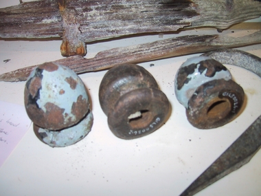
Ornamental drop finials x 4 from the lighthouse staircase.The four cast iron drop finials are decorative architectural features that were appended to the underside of the original lighthouse staircase, which was built between 1861 and 1862.The Conservation Management Plan prepared by Australian Construction Services in 1992 states that the original stair ‘was probably the first cast iron spiral stair to be built in an Australian lighthouse.’ From about 1978 to 1988 the tower’s original staircase was gradually removed and replaced by an iron replica and by 1992 the dismantled staircase had been shifted to the old jetty storage building and was ‘awaiting disposal’. Fortunately, it was not trashed but accessioned into the Eden Killer Whale Museum where it has since been incorporated into a recreated lighthouse.The staircase was removed from the tower prior to the lightstation’s inclusion in the Victorian Heritage Register in November 1999 (H1773). which may be the earliest cast iron spiral stair built in an Australian lighthouse.The four baluster drop finials are of first level contributory significance to the Gabo Island Lightstation for their historic value and clear provenance to the tower’s original staircase erected in 1862, which may be the earliest cast iron spiral stair built in an Australian lighthouse.4 x Cylindrical shaped finials. Threaded inside. Cast iron. tapers to a point. 1. & 2. have residue paint. -
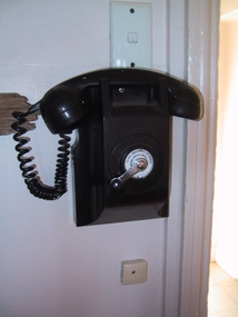
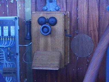
 Parks Victoria - Gabo Island LightstationThere are three, black Bakelite, wall mounted, crank handle telephones across the lightstation; one in the former assistant keeper’s quarters, and two in the former head keeper’s quarters. The phone has instructions for its use on the crank dial. Two have a coiled handset cord, which dates the phone to just after 1949 when these came into use. The third has a smooth cord and must pre date 1949. Another much older wall mounted phone remains in the lighthouse. The four telephones at Gabo Island formed an intercom system that facilitated communication between the lighthouse and lightstation buildings. They demonstrate the necessity for employing various methods of communication in a remotely located lighthouse as well as communication between the lightstation buildings. Telephones of the same wall mounted, crank dial type remain at Cape Otway, Point Hicks. As fixtures, the telephones belong to the building fabric and are included in the existing listing of the Gabo Island Lightstation in the Victorian Heritage Register (H1773). These intact items of equipment have first level contributory significance for their historic value and provenance.Black bakelite telephone, wall mounted with reciever/ handset on spiral cord attached to the body of the phone. There is a crank handle attached to the front of the telephone.On dial under crank handle. Outer perimeter of circular LABEL,"TO CALL:-TURN HANDLE & LIFT HANDSET / WHEN FINISHED PEPLACE HANDSET & TURN HANDLE"
 -
 Parks Victoria - Gabo Island Lightstation
Telephone
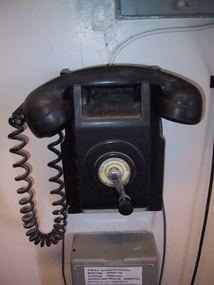
It has been restored by lightstation staff in 2002. The phone has a fixed mouth piece and is attached to the lantern room wall on a timber box mount. Dating from the early twentieth century, it is the earliest of four telephones at the lightstation and the sole box-mounted model, and is also the only telephone in the lighthouse. It has a crank handle, a separate black hand piece and an inclined horizontal shelf for jotting down notes. The four telephones provided an intercom system that facilitated communication between the lightstation buildings. Four other wall-mounted phones remain at the Cape Nelson Lightstation but unlike the Gabo Island example they do not provide a rest for jotting down notes. As a fixture, the telephone is part of the building fabric and is included in the existing Victorian Heritage Register extent of registration for the Gabo Island Lightstation (H1773). As a fixture, the telephone is part of the building fabric and is included in the existing Victorian Heritage Register extent of registration for the Gabo Island Lightstation (H1773). It is significant for its historic value and provenance, and relative uniqueness in a Victorian lighthouse.Telephone, wall-mounted in a wooden surround. Black crank handle on right-hand side. Separate black hand piece on left-hand side attached to main body by a fabric covered cord. The mouthpiece is fixed to the front of the telephone. There is a wooden rest attached to the lower front of phone on an angle. There are two half circular bells attached to the phone above the mouthpiece. -
 Ballarat Heritage Services
Photograph - Photograph - Colour, Clare Gervasoni, Carisbrook Police Lockup, c1998
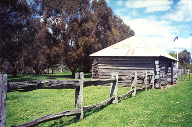
The Carisbrook Police Lockup, originally known as the Loddon Punt, was opened in 1851. At that time it was part of the Castlemaine Police District. Standing in the park beside Bucknall Street it is the town's one significant historic building. It was originally built on the police paddock adjacent to the primary school and moved to its present site in 1886. The walls are made of interlocking horizontally-laid logs. The shingle roof has been replaced with corrugated iron. The lockup was registered by the National Trust on 22/10/1964.Colour photograph of a log building known as the Carisbrook Police Lockup.carisbrook, carisbrook lockup, carisbrook police lockup, log cabin, police, police paddock -
 Whitehorse Historical Society Inc.
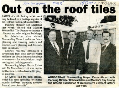
Article, Out on the roof tiles, 1994
... be listed on a heritage register of the Historic Buildings Council... on a heritage register of the Historic Buildings Council. City ...Parts of Monier Wunderlich tile factory in Vermont may be listed on a heritage register of the Historic Buildings Council.Parts of Monier Wunderlich tile factory in Vermont may be listed on a heritage register of the Historic Buildings Council. City of Nunawading has recently introduced a front desk service where residents can obtain information about requirements for subdivisions, engineering and building permits.Parts of Monier Wunderlich tile factory in Vermont may be listed on a heritage register of the Historic Buildings Council. tile factories, monier wunderlich tile factory, historic buildings, abbott, kevin, maclellan, rob, strong, ray, tuckerman, graeme -
Canterbury History Group
Document - Draft citation from the National Trust of Australia (Victoria), 4/03/1991 12:00:00 AM
... Register of Historic Buildings...Submission to the Historic Buildings Council from...) Register of Historic Buildings Canterbury Shopping Centre Environs ...Submission to the Historic Buildings Council from the National Trust of Australia (Victoria) citing Canterbury Mansions as being sufficiently of both architectural and historical importance to warrant its inclusion on the Register of Historic Buildings, with a covering letter.canterbury, canterbury mansions, canterbury road, national trust of australia (victoria), register of historic buildings, canterbury shopping centre environs urban renewal guidelines, butler> graeme, okraglik> henry -
Canterbury History Group
Pamphlet - Frognall 1888 - 1989, 1989
... Register of Historic Buildings... Register of Historic Buildings Moreton Bay Fig Trees ...Brief history of Frognall prepared by the Camberwell Council calling for ideas or proposals of future use for the mansion. Includes floor plans of the ground floor, first floor and stables. (dated 1890)canterbury, frognall, royal australian air force, mont albert road, camberwell council, register of historic buildings, moreton bay fig trees -
 Flagstaff Hill Maritime Museum and Village
Photograph - Vessels - Sail and Steam, c. 1972-1975
Andy Clapham owned and operated a boat yard on the Maribyrnong River in Footscray, Victoria. The river runs into Port Phillip Bay (sometimes known as Hobson’s bay) at Williamstown, an area with a history of trades associated with the shipping and construction industry. Andy Clapham’s photographs include those of the Reginald M and one of Polly Woodside, another vessel restored and used as a maritime exhibition. Andy Clapham’s letter of 1972 was posted in a and envelope with an early Australian decimal currency stamp showing the profile portrait of Queen Elizabeth II, and valued at 7 cent. Andy offered invaluable advice to the Flagstaff Hill Historic Park Planning Board regarding the purchase a vessel suitable for use as an exhibit once Flagstaff Hill was opened. The Planning Board was set up by the Warrnambool Chamber of Commerce and approved by the City Council and State Government. Flagstaff Hill was investigating vessels in Adelaide and Tasmania as well as Melbourne. Andy looked at several vessels in 1972-1973. He also serviced the Reginald M among other vessels belonging to Captain Julian Dyson of Yarra Ferries, who had casually offered the vessel to Flagstaff Hill as a price that was unattainable at the time. Flagstaff Hill later requested photographs of the hull to discern the dimensions and also the condition of the timbers as well as wanting advice on its seafaring capability. In 1972 the Flagstaff Hill Historic Park Planning Board – Chairman J. (John) S. Lindsay (1972-1980), Secretary J. (James) Mark – wrote a letter of appreciation to Mr A. (Andy) Clapham of 3 Charles Street Footscray ... “Dear Mr. Clapham, The Board has asked me to write to you to express our appreciation for the assistance you have offered us through our Chairman John Lindsay. The information you have already given us has been invaluable, in that is shows us that we have not been setting out to do something that is impossible. We look forward to receiving further information from you as it becomes available and we appreciate that you must be busy enough without our problems. Members of our Board hope to call and see you on a trip to Melbourne in the near future. The Board is optimistic about the future of Flagstaff Hill as a Maritime Museum and look forward to you visiting Warrnambool to examine what we believe will be an ideal site. Yours faithfully, James Mark.” ABOUT the vessel “Reginald M” The vessel “Reginald M” was a two-masted, timber coastal vessel built by John Henry Murch in Birkenhead, Port of Adelaide, South Australia. It was named after Reginald Murch. (It was occasionally referred to as the Reginald “Emm”). Its construction took approximately 6 months using many materials and fittings from salvage yards. It is believed that the keep was hewn from two telegraph poles! Reginald M was launched at Largs Bay in 1922. Reginald M was approximately 30 metres long and was fore-to-aft ketch rigged with an ‘auxiliary’ motor to support any loss of sail power. The Reginald M was built to service the coastal ports of South Australia to Port Victoria on the York Peninsular, Spencer Gulf. It freighted cargo from port to port cheaply and efficiently. It had a very shallow draft and a flat bottom, enabling it to come close to shore and sit high and dry at low tide, or to be beached on the sand. It could easily skim over reefs due to its flat bottom. Wagons could be loaded and unloaded directly from the side of the vessel. Over the years her cargo included guano, barley, wool, horses, cattle, timber, explosives, potatoes, shell grit and gypsum. The Murch brothers from Port Adelaide were owners of the Reginald M and Richard Murch as the Captain. On April 9, 1931, Reginald M weathered a large storm in St. Vincents Gulf, SA, suffering much damage; the mast snapped and the crew laboured for four hours to free it up by severing the mast and rigging. The crew patched it up and slowly returned to Port Adelaide with only a portion of the insured cargo being damaged. The crew members at that time were owner Mr John Henry Murch of Wells Street Largs Bay, Skipper Mr R Murch – John’s brother, Murray – son of Captain Murch and Seaman John Smith. At some stage it seems that the Reginald M was used as a Customs vessel “H.M.C. No. 3, Pt Adelaide” as shown in a photograph in Flagstaff Hill’s collection. In 1969 Reginald M’s last freight trip left Marion Bay, carrying grain, wool and explosives. In late 1970 it was sold to the Mount Lyall Mining and Railway Clompany and used as a barge to carry explosives. In 1972 The Navy League of Strahan, Tasmania, purchased the vessel for use by the Strahan Sea Cadet Unit at Macquarie Harbour; it was renamed “T.S. Macquarie”. (This plan did not come to pass.) In 1974 Mr Andrew Rennie of East Brighton, Melbourne, brought Reginald M for shipping purposes, He sailed it from Strahan to Melbourne, planning to use it for pleasure sailing. The Reginald M was later sold at auction to Captain Julian Dyson, owner of Yarra Passenger Ferries in Melbourne. Later in 1975 funds became available to Flagstaff Hill Maritime Village to purchase the Reginald M. It was then restored and used as an exhibit here for many hears. Flagstaff Hill’s collection also includes various objects related to the Reginald M: - Photographs of Reginald M over the years in various aspects of its use - a life buoy with the inscription of “Pt. Adelaide” - helm section that was removed and replaced during restoration - a bullet found in pieces of timber during the 1979 restoration ABOUT THE POLLY WOODSIDE On the bow in the Polly Woodside's photograph is the word "RONA". the Polly Woodside was built at Belfast in 1885. In 1904 the vessel was sold to A.H. Turnbull of New Zealand and renamed "RONA". The letter and photographs are significant for their association with the Reginald M, an Australian built coastal trader now on the Australian Register of Historic Vessels (number HV000562). The letter and photographs are also significant as part of both the history of Flagstaff Hill and the history of the vessel “Reginald M” that has been on display in the lake for many years. Objects retained from this boat are included in Flagstaff Hill’s collection of maritime history.Packet with photographs and negatives in a KODAK envelope. The photographs are of two sail and steam vessels; twelve (12) black and white photographs of the 'Reginald M', and one (1) colour photograph of the Polly Woodside, plus six (6) negative strips. Included int he packet is a letter in stamped and postmarked envelope addressed to Mr A Clapham of Footscray. The envelope postmarked 9 Dec 1972, with the Warrnambool postcode 3280, A 7c Australian postage stamp in attached to the envelope. They are associated with Flagstaff Hill’s acquisition of the vessel “Reginald M”. Envelope "9 DEC 1972 / 3280" Postage stamp "7c" "Australia" Inscriptions on one Reginald M;; "REGINALD M" and "Pt ADELAIDE H.M.C. No. 3" Inscriptions of the Polly Woodside; "RONA / MSC" "MHI / NO. 1" Ball point ink, reverse of photograph "POLLY WOODSIDE"flagstaff hill, warrnambool, shipwrecked coast, flagstaff hill maritime museum, maritime museum, shipwreck coast, flagstaff hill maritime village, great ocean road, vessel reginald m, reginald emm, t. s. macquarie, h.m.c. no. 3, pt adelaide, australian register of historic vessels (number hv000562), boat building trade, jack murch, john henry murch, birkenhead, port adelaide sa, largs bay sa, coastal trader south australia, 1920 ketch reginald m, marion bay produce, mount lyall mining and railway company, navy league of strahan, tasmania, melbourne ferry company, flagstaff hill historic park planning board, john lindsay, james mark, andy clapham of footscray, andy clapham boat builder, kodak photograph packet envelope, kodak super-size prints, kodak australia pty ltd, australian postage stamp 1972 - 7c -
 Glen Eira Historical Society
Album - Album page, Labassa Conservatory, 21 Manor Grove, Circa 1972
This photograph is part of the Caulfield Historical Album 1972. This album was created in approximately 1972 as part of a project by the Caulfield Historical Society to assist in identifying buildings worthy of preservation. The album is related to a Survey the Caulfield Historical Society developed in collaboration with the National Trust of Australia (Victoria) and Caulfield City Council to identify historic buildings within the City of Caulfield that warranted the protection of a National Trust Classification. Principal photographer thought to be Trevor Hart, member of Caulfield Historical Society. Most photographs were taken between 1966-1972 with a small number of photographs being older and from unknown sources. All photographs are black and white except where stated, with 386 photographs over 198 pages. WHAT IS SIGNIFICANT? [From Victorian Heritage Database citation for Former Labassa Conservatory - H2005 Victorian Heritage Register http://vhd.heritage.vic.gov.au/places/result_detail/12504 (25/01/2021)] The former Labassa Conservatory is believed to have been built as part of the extensive reworking of the Labassa estate in c1890 for the new owner Alexander Robertson, proprietor of the Cobb and Co line. Robertson commissioned the architect JAB Koch to remodel the house, and Koch may have been responsible for the conservatory as well. Alternatively, the conservatory may have been imported. The gates installed at Labassa in 1890 were manufactured by the MacFarlane foundry of Glasgow, Scotland, a firm known to have manufactured conservatories. Around 1917 the glass house from 'Labassa', Caulfield was offered for sale to Malvern Council for its own gardens but the offer was declined. Following subdivision of the Labassa estate in the 1920s the conservatory was converted into a residence. The structure has a simple rectangular plan, with a brick base and superstructure of cast iron columns and roof trusses. The hipped roof is surmounted by an elaborately decorated gable structure. Most of the original glass has been replaced by metal sheeting. The decoration comprises pressed metal fascias including an egg and dart style cornice moulding, mullion mouldings and gable end panels with a rising sun motif. Cast iron ridgework and finials add to the lively roof form. Internally the floor appears to have been raised as part of the conversion work to a residence, and stained timber panelling introduced to provide room spaces. Boilers probably heated the conservatory in the colder months, but these do not survive.From Victorian Heritage Database citation for Former Labassa Conservatory - H2005 http://vhd.heritage.vic.gov.au/places/result_detail/12504 (25/01/2021) HOW IS IT SIGNIFICANT? The former Labassa Conservatory is of historical and architectural significance to the State of Victoria. WHY IS IT SIGNIFICANT? The former Labassa Conservatory is historically significant for its associations with the Labassa estate. Subdivision of the estate separated a number of outbuildings from the mansion. The former conservatory is significant as part of the large scale improvements carried out to the estate in the 1890s. The nineteenth century was the great age of conservatory designs, enabled by technological developments in heating, glazing and iron. Whilst conservatories were common in botanical gardens and universities, where they were primarily used for cultivating, studying, and experimenting with plants, they had also become an accessory of the wealthy on private estates. The former Labassa conservatory is architecturally significant as a rare example of a building type. Many Victorian mansion houses had attached conservatories, but detached conservatories were much less common. The only other detached example associated with a residence known to survive on its original site in Victoria is an earlier example at Warrock homestead, near Casterton. Conservatories attached to nineteenth century mansions are far more numerous. The Labassa example is very ornate, and its decoration draws on the versatility of pressed metal and cast iron. This highlights the dual purpose of the conservatory, as both a functional structure and a picturesque building on the Labassa estate. This building is unusual as an example converted to residential use. Page 130 of Photograph Album with one portrait photograph of Labassa's conservatory.Handwritten: "Labassa" conservatory 21 Manor Grove [top right] /130 [bottom right]bracketed eaves, caulfield north, labassa, balaclava road, orrong road, sylliott hill, alexander william robertson, ontario, john a. b. koch, john boyd watson, mouldings, 1920's, la bassa, manor grove, st kilda east, architects, john koch, greenhouses, gardens, plants, land subdivisions, gates, macfarlane foundry, brick, cast iron work, hipped roofs, gables, 1890's -
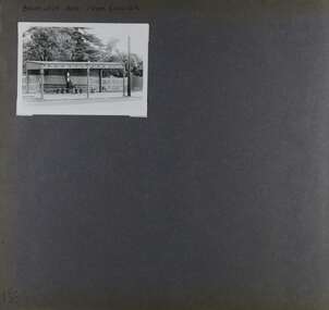 Glen Eira Historical Society
Album - Album page, Balaclava Road Tram Shelter, Circa 1972
This photograph is part of the Caulfield Historical Album 1972. This album was created in approximately 1972 as part of a project by the Caulfield Historical Society to assist in identifying buildings worthy of preservation. The album is related to a Survey the Caulfield Historical Society developed in collaboration with the National Trust of Australia (Victoria) and Caulfield City Council to identify historic buildings within the City of Caulfield that warranted the protection of a National Trust Classification. Principal photographer thought to be Trevor Hart, member of Caulfield Historical Society. Most photographs were taken between 1966-1972 with a small number of photographs being older and from unknown sources. All photographs are black and white except where stated, with 386 photographs over 198 pages. From Victorian Heritage Database citation H0174 TRAM VERANDAH SHELTER CORNER BALACLAVA AND ORRONG ROADS CAULFIELD NORTH - Vic Heritage Register https://vhd.heritagecouncil.vic.gov.au/places/2721 (as at 28/10/2020) The waiting shelter at the corner of Balaclava Road and Orrong Road, Caulfield was constructed in 1916/17 for the Prahran and Malvern Tramways Trust and is one of only three remaining tram shelters in Melbourne designed in the form of a verandah. The shelter has a corrugated iron roof fixed to an angle iron roof frame. The roof, which extends in the form of a skillion over the pavement, is supported on three squared, chamfered timber posts at the rear and three cast iron reeded columns with round bases and Corinthian capitals at the front. (The columns are hollow and function as downpipes, with rainwater discharging from the verandah roof, through the columns and under the ground). The shelter has a rinceau pattern frieze along the road frontage with centrally placed shield motif (which does not contain a coat of arms). The side and rear panels are lined with ripple iron and the upper panel at the rear is lattice work. The shelter has two timber slatted bench seats.From Victorian Heritage Database citation for H0174 TRAM VERANDAH SHELTER CORNER BALACLAVA AND ORRONG ROADS CAULFIELD NORTH - Vic Heritage Register https://vhd.heritagecouncil.vic.gov.au/places/2721 (as at 28/10/2020) How is it significant? The waiting shelter at the corner of Balaclava Road and Orrong Road, Caulfield is of historical and architectural significance to the State of Victoria. Why is it significant? The waiting shelter is of historical significance for its association with the development of the suburban (electric) tram network which assisted the expansion of Melbourne as a suburban metropolis. It is also of historical significance for its connection with the Prahran & Malvern Tramways Trust. The Prahran & Malvern Tramways Trust (1907-1920) was the first municipal electric tramway in Melbourne, becoming the largest and most successful of all the municipal tramway trusts. Its services played a key role in facilitating suburban expansion and the development of the southern and eastern suburbs. The growth of tramways was one of the greatest municipal developments in Victoria during the first decade of the twentieth century. The waiting shelter is an important remnant of this period of Melbourne's transport history and a tangible reminder of the Prahran & Malvern Tramways Trust. The shelter indicates the extent of the Prahran & Malvern tram network. The waiting shelter at corner of Balaclava Road and Orrong Road, Caulfield is one of only three remaining tram shelters in Melbourne designed in the form of a verandah. The waiting shelter is of architectural significance for the distinctive design and construction which is unique to the Prahran & Malvern Tramway Trust tram network. The shelter was designed by notable Melbourne architect Leonard J. Flannagan (1864-1946). Flannagan was responsible for a number of buildings for the Prahran and Malvern Tramways Trust including the early waiting shelter at the junction of Dandenong Road and Hawthorn Road, Caulfield, and sections of the tram depot at Malvern, and also designed a depot for the Hawthorn Tramways Trust. The waiting shelter, a conservative design influenced by Victorian architecture, is based on the Melbourne City Council late 19th century standard cast iron verandah. It is of significance as an intact example of the cast iron type shelter and for its detail, including Corinthian columns and a 'rinceau' pattern cast-iron frieze. The shelter is largely in keeping with the original design and retains its integrity. The cast iron waiting shelter is also of significance as an unusual example of early twentieth century street architecture. Page 155 of Photograph Album with one landscape photograph of a tram shelter on Balaclava Road.Handwritten: BALACLAVA ROAD TRAM SHELTER [top] / 155 [bottom left]trevor hart, verandah, garden, grimwade house, grimwade, orrong road, balaclava road, melbourne grammar, melbourne grammar junior school, mgs, m.g.s, school, tram shelter, waiting shelter, prahran & malvern tramway trust, leonard j. flannagan, cast iron verandah, cast iron type shelter, corinthian columns, 'rinceau' pattern cast-iron frieze, rinceau, cast iron frieze, victorian style, caulfield north, leonard flanagan, cast iron work, prahran and malvern tramways trust, trams